
Polk County, Oregon
Encyclopedia
Polk County is a county located in the U.S. state
of Oregon
. The county is named
for James Knox Polk, the 11th president of the United States. In 2010, its population was 75,403. The seat
of the county is Dallas
.
Polk County is part of the Salem
Metropolitan Statistical Area
.
in Oregon, at 1322 acres (5.3 km²). Western Oregon University
in Monmouth
is a major employer.
in Polk County, as well as most rural counties in Oregon, are members of the Republican Party
. In the 2008 presidential election
, 48.92% of Polk County voters voted for Republican John McCain
, while 48.43% voted for Democrat
Barack Obama
and 2.64% of voters either voted for a Third Party
candidate or wrote in
a candidate. These numbers show a small shift towards the Democratic candidate when compared to the 2004 presidential election
, in which 55% of Polk Country voters voted for George W. Bush
, while 43.6% voted for John Kerry
, and 1.4% of voters either voted for a Third Party candidate or wrote in a candidate
.
, the county has a total area of 744 square miles (1,927 km²), of which 741 square miles (1,919.2 km²) is land and 3 square miles (7.8 km²) (0.42%) is water.
About two thirds of Polk County, in the western part of the county is forest
, mostly of the coniferous and mixed
varieties, bordering on temperate rain forest
around Laurel Mountain, the wettest place in Oregon.
The eastern half of the county lies in the Willamette Valley
. The Willamette River
forms the eastern border of the county, separating it from neighboring Marion County, Oregon
.
of 2000, there were 62,380 people, 23,058 households, and 16,140 families residing in the county. The population density
was 84 people per square mile (32/km²). There were 24,461 housing units at an average density of 33 per square mile (13/km²). The racial makeup of the county was 89.19% White
, 0.42% Black
or African American
, 1.85% Native American
, 1.09% Asian
, 0.25% Pacific Islander
, 4.48% from other races
, and 2.72% from two or more races. 8.78% of the population were Hispanic
or Latino
of any race. 20.4% were of German, 12.3% English
, 7.6% American
and 7.4% Irish
ancestry according to Census 2000.
There were 23,058 households out of which 32.10% had children under the age of 18 living with them, 57.10% were married couples
living together, 9.20% had a female householder with no husband present, and 30.00% were non-families. 22.30% of all households were made up of individuals and 9.90% had someone living alone who was 65 years of age or older. The average household size was 2.62 and the average family size was 3.07.
In the county, the population was spread out with 25.40% under the age of 18, 11.70% from 18 to 24, 24.70% from 25 to 44, 23.40% from 45 to 64, and 14.80% who were 65 years of age or older. The median age was 36 years. For every 100 females there were 94.00 males. For every 100 females age 18 and over, there were 89.60 males.
The median income for a household in the county was $42,311, and the median income for a family was $50,483. Males had a median income of $36,667 versus $26,272 for females. The per capita income
for the county was $19,282. About 6.30% of families and 11.50% of the population were below the poverty line, including 12.50% of those under age 18 and 5.50% of those age 65 or over.
created Polk County from Yamhill District
on December 22, 1845, granting to it the entire southwestern portion of present day Oregon to the California
border. County boundaries were periodically changed to reflect the creation of Benton
and Lincoln
counties. Many other counties were subsequently carved out of these as settlement spread towards the south, leaving Polk County many counties away from its former border with California.
The first county seat was a settlement on the north side of Rickreall Creek
named Cynthian (also known as Cynthia Ann). In 1852 city officials renamed Cynthian to Dallas
after Vice President George M. Dallas
, vice president to James Polk. During the 1880s and 1890s, there were a series of unsuccessful efforts to move the county seat to nearby Independence
.
U.S. state
A U.S. state is any one of the 50 federated states of the United States of America that share sovereignty with the federal government. Because of this shared sovereignty, an American is a citizen both of the federal entity and of his or her state of domicile. Four states use the official title of...
of Oregon
Oregon
Oregon is a state in the Pacific Northwest region of the United States. It is located on the Pacific coast, with Washington to the north, California to the south, Nevada on the southeast and Idaho to the east. The Columbia and Snake rivers delineate much of Oregon's northern and eastern...
. The county is named
Oregon Geographic Names
Oregon Geographic Names is an authoritative compilation of the origin and meaning of place names in the U.S. state of Oregon. , the book is in its seventh edition and is compiled and edited by Lewis L. McArthur, who took over from his father, Lewis A. McArthur, as of the fourth edition...
for James Knox Polk, the 11th president of the United States. In 2010, its population was 75,403. The seat
County seat
A county seat is an administrative center, or seat of government, for a county or civil parish. The term is primarily used in the United States....
of the county is Dallas
Dallas, Oregon
The city of Dallas is the county seat of Polk County, Oregon, United States. The population was 14,583 at the 2010 census.Dallas is located on Rickreall Creek, approximately 15 miles west of Salem, at an altitude of 325 feet above sea level...
.
Polk County is part of the Salem
Salem, Oregon
Salem is the capital of the U.S. state of Oregon, and the county seat of Marion County. It is located in the center of the Willamette Valley alongside the Willamette River, which runs north through the city. The river forms the boundary between Marion and Polk counties, and the city neighborhood...
Metropolitan Statistical Area
Salem Metropolitan Statistical Area
The Salem Metropolitan Statistical Area , as defined by the United States Census Bureau, is an area consisting of two counties in western Oregon, Marion and Polk. The principal city is Salem, the state capital, which has a population of 154,637. As of the 2010 census, there were 390,738 people...
.
Economy
The major industries of the county are agriculture, forest products, manufacturing, and education. Polk County has the second-largest area devoted to viticultureViticulture
Viticulture is the science, production and study of grapes which deals with the series of events that occur in the vineyard. When the grapes are used for winemaking, it is also known as viniculture...
in Oregon, at 1322 acres (5.3 km²). Western Oregon University
Western Oregon University
Western Oregon University is a public liberal arts college located in Monmouth, Oregon, United States. It was originally established in 1856 by Oregon pioneers as Monmouth University. Subsequent names include Oregon Normal School, Oregon College of Education, and Western Oregon State College...
in Monmouth
Monmouth, Oregon
- History :Monmouth was settled in 1853 by a group of pioneers who made a point of allocating to build both a city and a "college under the auspices of the Christian Church" and proceeds from the sale of these lands were used to found Monmouth University. By the early 1880s the college fell on...
is a major employer.
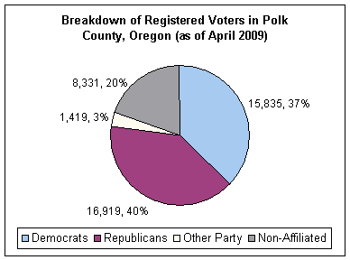
Politics
Though Polk County is located in western Oregon, politically it falls in line with the eastern side of the state. The majority of registered voters who are part of a political partyPolitical party
A political party is a political organization that typically seeks to influence government policy, usually by nominating their own candidates and trying to seat them in political office. Parties participate in electoral campaigns, educational outreach or protest actions...
in Polk County, as well as most rural counties in Oregon, are members of the Republican Party
Republican Party (United States)
The Republican Party is one of the two major contemporary political parties in the United States, along with the Democratic Party. Founded by anti-slavery expansion activists in 1854, it is often called the GOP . The party's platform generally reflects American conservatism in the U.S...
. In the 2008 presidential election
United States presidential election, 2008
The United States presidential election of 2008 was the 56th quadrennial presidential election. It was held on November 4, 2008. Democrat Barack Obama, then the junior United States Senator from Illinois, defeated Republican John McCain, the senior U.S. Senator from Arizona. Obama received 365...
, 48.92% of Polk County voters voted for Republican John McCain
John McCain
John Sidney McCain III is the senior United States Senator from Arizona. He was the Republican nominee for president in the 2008 United States election....
, while 48.43% voted for Democrat
Democratic Party (United States)
The Democratic Party is one of two major contemporary political parties in the United States, along with the Republican Party. The party's socially liberal and progressive platform is largely considered center-left in the U.S. political spectrum. The party has the lengthiest record of continuous...
Barack Obama
Barack Obama
Barack Hussein Obama II is the 44th and current President of the United States. He is the first African American to hold the office. Obama previously served as a United States Senator from Illinois, from January 2005 until he resigned following his victory in the 2008 presidential election.Born in...
and 2.64% of voters either voted for a Third Party
Third party (politics)
In a two-party system of politics, the term third party is sometimes applied to a party other than the two dominant ones. While technically the term is limited to the third largest party or third oldest party, it is common, though innumerate, shorthand for any smaller party.For instance, in the...
candidate or wrote in
Write-in candidate
A write-in candidate is a candidate in an election whose name does not appear on the ballot, but for whom voters may vote nonetheless by writing in the person's name. Some states and local jurisdictions allow a voter to affix a sticker with a write-in candidate's name on it to the ballot in lieu...
a candidate. These numbers show a small shift towards the Democratic candidate when compared to the 2004 presidential election
United States presidential election, 2004
The United States presidential election of 2004 was the United States' 55th quadrennial presidential election. It was held on Tuesday, November 2, 2004. Republican Party candidate and incumbent President George W. Bush defeated Democratic Party candidate John Kerry, the then-junior U.S. Senator...
, in which 55% of Polk Country voters voted for George W. Bush
George W. Bush
George Walker Bush is an American politician who served as the 43rd President of the United States, from 2001 to 2009. Before that, he was the 46th Governor of Texas, having served from 1995 to 2000....
, while 43.6% voted for John Kerry
John Kerry
John Forbes Kerry is the senior United States Senator from Massachusetts, the 10th most senior U.S. Senator and chairman of the Senate Foreign Relations Committee. He was the presidential nominee of the Democratic Party in the 2004 presidential election, but lost to former President George W...
, and 1.4% of voters either voted for a Third Party candidate or wrote in a candidate
Write-in candidate
A write-in candidate is a candidate in an election whose name does not appear on the ballot, but for whom voters may vote nonetheless by writing in the person's name. Some states and local jurisdictions allow a voter to affix a sticker with a write-in candidate's name on it to the ballot in lieu...
.
Geography
According to the U.S. Census BureauUnited States Census Bureau
The United States Census Bureau is the government agency that is responsible for the United States Census. It also gathers other national demographic and economic data...
, the county has a total area of 744 square miles (1,927 km²), of which 741 square miles (1,919.2 km²) is land and 3 square miles (7.8 km²) (0.42%) is water.
About two thirds of Polk County, in the western part of the county is forest
Forest
A forest, also referred to as a wood or the woods, is an area with a high density of trees. As with cities, depending where you are in the world, what is considered a forest may vary significantly in size and have various classification according to how and what of the forest is composed...
, mostly of the coniferous and mixed
Mixed
Mixed is the past tense of mix. It may also refer to:*Mixed breed, an animal whose parents are from different breeds or species*Mixed anomaly, in theoretical physics, an example of an anomaly*Mixed data sampling, an econometric model developed by Ghysels...
varieties, bordering on temperate rain forest
Temperate rain forest
Temperate rainforests are coniferous or broadleaf forests that occur in the temperate zone and receive high rainfall.-Definition:For temperate rain forests of North America, Alaback's definition is widely recognized:-Global distribution:...
around Laurel Mountain, the wettest place in Oregon.
The eastern half of the county lies in the Willamette Valley
Willamette Valley
The Willamette Valley is the most populated region in the state of Oregon of the United States. Located in the state's northwest, the region is surrounded by tall mountain ranges to the east, west and south and the valley's floor is broad, flat and fertile because of Ice Age conditions...
. The Willamette River
Willamette River
The Willamette River is a major tributary of the Columbia River, accounting for 12 to 15 percent of the Columbia's flow. The Willamette's main stem is long, lying entirely in northwestern Oregon in the United States...
forms the eastern border of the county, separating it from neighboring Marion County, Oregon
Marion County
Marion County is the name of seventeen counties in the United States of America, mostly named for General Francis Marion:* Marion County, Alabama* Marion County, Arkansas* Marion County, Florida* Marion County, Georgia* Marion County, Illinois...
.
Adjacent counties
- Yamhill CountyYamhill County, Oregon-National protected areas:*Siuslaw National Forest *Tualatin River National Wildlife Refuge -Demographics:As of the census of 2000, there were 84,992 people, 28,732 households, and 21,376 families residing in the county. The population density was 119 people per square mile . There were 30,270...
(north) - Marion CountyMarion County, OregonMarion County is a county located in the U.S. state of Oregon. It was originally named the Champooick District, after Champoeg, a meeting place on the Willamette River. On September 3, 1849, the territorial legislature renamed it in honor of Francis Marion, a Continental Army general of the...
(east) - Benton CountyBenton County, Oregon-National protected areas:*Siuslaw National Forest *William L. Finley National Wildlife Refuge-Demographics:As of the census of 2000, there were 78,153 people, 30,145 households, and 18,237 families residing in the county. The population density was 116 people per square mile . There were 31,980...
(south) - Lincoln CountyLincoln County, Oregon-National protected areas:*Oregon Islands National Wildlife Refuge *Siletz Bay National Wildlife Refuge*Siuslaw National Forest -Demographics:...
(west) - Tillamook CountyTillamook County, OregonTillamook County is a county located in the U.S. state of Oregon. The county is named for the Tillamook, a Native American tribe who were living in the area in the early 19th century at the time of European American settlement. In 2010, the county's population was 25,250...
(northwest)
National protected areas
- Baskett Slough National Wildlife RefugeBaskett Slough National Wildlife RefugeBaskett Slough National Wildlife Refuge is located in northwestern Oregon, 10 miles west of Salem in Polk County. Situated in open farmland near the eastern foothills of the Oregon Coast Range with the broad Willamette Valley and the Cascade Range to the east, elevations range from 185 to...
- Siuslaw National ForestSiuslaw National ForestSiuslaw National Forest is a national forest in western Oregon, United States. Established in 1908, the Siuslaw is made up of a wide variety of ecosystems, ranging from coastal forests to sand dunes.- Geography :...
(part)
Demographics
As of the censusCensus
A census is the procedure of systematically acquiring and recording information about the members of a given population. It is a regularly occurring and official count of a particular population. The term is used mostly in connection with national population and housing censuses; other common...
of 2000, there were 62,380 people, 23,058 households, and 16,140 families residing in the county. The population density
Population density
Population density is a measurement of population per unit area or unit volume. It is frequently applied to living organisms, and particularly to humans...
was 84 people per square mile (32/km²). There were 24,461 housing units at an average density of 33 per square mile (13/km²). The racial makeup of the county was 89.19% White
Race (United States Census)
Race and ethnicity in the United States Census, as defined by the Federal Office of Management and Budget and the United States Census Bureau, are self-identification data items in which residents choose the race or races with which they most closely identify, and indicate whether or not they are...
, 0.42% Black
Race (United States Census)
Race and ethnicity in the United States Census, as defined by the Federal Office of Management and Budget and the United States Census Bureau, are self-identification data items in which residents choose the race or races with which they most closely identify, and indicate whether or not they are...
or African American
Race (United States Census)
Race and ethnicity in the United States Census, as defined by the Federal Office of Management and Budget and the United States Census Bureau, are self-identification data items in which residents choose the race or races with which they most closely identify, and indicate whether or not they are...
, 1.85% Native American
Race (United States Census)
Race and ethnicity in the United States Census, as defined by the Federal Office of Management and Budget and the United States Census Bureau, are self-identification data items in which residents choose the race or races with which they most closely identify, and indicate whether or not they are...
, 1.09% Asian
Race (United States Census)
Race and ethnicity in the United States Census, as defined by the Federal Office of Management and Budget and the United States Census Bureau, are self-identification data items in which residents choose the race or races with which they most closely identify, and indicate whether or not they are...
, 0.25% Pacific Islander
Race (United States Census)
Race and ethnicity in the United States Census, as defined by the Federal Office of Management and Budget and the United States Census Bureau, are self-identification data items in which residents choose the race or races with which they most closely identify, and indicate whether or not they are...
, 4.48% from other races
Race (United States Census)
Race and ethnicity in the United States Census, as defined by the Federal Office of Management and Budget and the United States Census Bureau, are self-identification data items in which residents choose the race or races with which they most closely identify, and indicate whether or not they are...
, and 2.72% from two or more races. 8.78% of the population were Hispanic
Race (United States Census)
Race and ethnicity in the United States Census, as defined by the Federal Office of Management and Budget and the United States Census Bureau, are self-identification data items in which residents choose the race or races with which they most closely identify, and indicate whether or not they are...
or Latino
Race (United States Census)
Race and ethnicity in the United States Census, as defined by the Federal Office of Management and Budget and the United States Census Bureau, are self-identification data items in which residents choose the race or races with which they most closely identify, and indicate whether or not they are...
of any race. 20.4% were of German, 12.3% English
English people
The English are a nation and ethnic group native to England, who speak English. The English identity is of early mediaeval origin, when they were known in Old English as the Anglecynn. England is now a country of the United Kingdom, and the majority of English people in England are British Citizens...
, 7.6% American
United States
The United States of America is a federal constitutional republic comprising fifty states and a federal district...
and 7.4% Irish
Irish people
The Irish people are an ethnic group who originate in Ireland, an island in northwestern Europe. Ireland has been populated for around 9,000 years , with the Irish people's earliest ancestors recorded having legends of being descended from groups such as the Nemedians, Fomorians, Fir Bolg, Tuatha...
ancestry according to Census 2000.
There were 23,058 households out of which 32.10% had children under the age of 18 living with them, 57.10% were married couples
Marriage
Marriage is a social union or legal contract between people that creates kinship. It is an institution in which interpersonal relationships, usually intimate and sexual, are acknowledged in a variety of ways, depending on the culture or subculture in which it is found...
living together, 9.20% had a female householder with no husband present, and 30.00% were non-families. 22.30% of all households were made up of individuals and 9.90% had someone living alone who was 65 years of age or older. The average household size was 2.62 and the average family size was 3.07.
In the county, the population was spread out with 25.40% under the age of 18, 11.70% from 18 to 24, 24.70% from 25 to 44, 23.40% from 45 to 64, and 14.80% who were 65 years of age or older. The median age was 36 years. For every 100 females there were 94.00 males. For every 100 females age 18 and over, there were 89.60 males.
The median income for a household in the county was $42,311, and the median income for a family was $50,483. Males had a median income of $36,667 versus $26,272 for females. The per capita income
Per capita income
Per capita income or income per person is a measure of mean income within an economic aggregate, such as a country or city. It is calculated by taking a measure of all sources of income in the aggregate and dividing it by the total population...
for the county was $19,282. About 6.30% of families and 11.50% of the population were below the poverty line, including 12.50% of those under age 18 and 5.50% of those age 65 or over.
History
The Oregon Provisional LegislatureProvisional Legislature of Oregon
The Provisional Legislature of Oregon was the single-chamber legislative body of the Provisional Government of Oregon. It served the Oregon Country of the Pacific Northwest of North America from 1843 until early 1849 at a time when no country had sovereignty over the region...
created Polk County from Yamhill District
Yamhill County, Oregon
-National protected areas:*Siuslaw National Forest *Tualatin River National Wildlife Refuge -Demographics:As of the census of 2000, there were 84,992 people, 28,732 households, and 21,376 families residing in the county. The population density was 119 people per square mile . There were 30,270...
on December 22, 1845, granting to it the entire southwestern portion of present day Oregon to the California
California
California is a state located on the West Coast of the United States. It is by far the most populous U.S. state, and the third-largest by land area...
border. County boundaries were periodically changed to reflect the creation of Benton
Benton County, Oregon
-National protected areas:*Siuslaw National Forest *William L. Finley National Wildlife Refuge-Demographics:As of the census of 2000, there were 78,153 people, 30,145 households, and 18,237 families residing in the county. The population density was 116 people per square mile . There were 31,980...
and Lincoln
Lincoln County, Oregon
-National protected areas:*Oregon Islands National Wildlife Refuge *Siletz Bay National Wildlife Refuge*Siuslaw National Forest -Demographics:...
counties. Many other counties were subsequently carved out of these as settlement spread towards the south, leaving Polk County many counties away from its former border with California.
The first county seat was a settlement on the north side of Rickreall Creek
Rickreall Creek
Rickreall Creek is a stream in Polk County, Oregon, United States rising on Laurel Mountain in the Central Oregon Coast Range and draining into the Willamette River west of Salem at Eola. The creek passes through the city of Dallas and the unincorporated community of Rickreall...
named Cynthian (also known as Cynthia Ann). In 1852 city officials renamed Cynthian to Dallas
Dallas, Oregon
The city of Dallas is the county seat of Polk County, Oregon, United States. The population was 14,583 at the 2010 census.Dallas is located on Rickreall Creek, approximately 15 miles west of Salem, at an altitude of 325 feet above sea level...
after Vice President George M. Dallas
George M. Dallas
George Mifflin Dallas was a U.S. Senator from Pennsylvania and the 11th Vice President of the United States , serving under James K. Polk.-Family and early life:...
, vice president to James Polk. During the 1880s and 1890s, there were a series of unsuccessful efforts to move the county seat to nearby Independence
Independence, Oregon
Independence is a city in Polk County, Oregon, United States, on the west bank of the Willamette River along Oregon Route 51, and east of nearby Monmouth. It is part of the Salem Metropolitan Statistical Area...
.
Incorporated cities
- DallasDallas, OregonThe city of Dallas is the county seat of Polk County, Oregon, United States. The population was 14,583 at the 2010 census.Dallas is located on Rickreall Creek, approximately 15 miles west of Salem, at an altitude of 325 feet above sea level...
- Falls CityFalls City, OregonFalls City is a city in Polk County, Oregon, United States. The population was 966 at the 2000 census. It is part of the Salem Metropolitan Statistical Area.-History:...
- IndependenceIndependence, OregonIndependence is a city in Polk County, Oregon, United States, on the west bank of the Willamette River along Oregon Route 51, and east of nearby Monmouth. It is part of the Salem Metropolitan Statistical Area...
- MonmouthMonmouth, Oregon- History :Monmouth was settled in 1853 by a group of pioneers who made a point of allocating to build both a city and a "college under the auspices of the Christian Church" and proceeds from the sale of these lands were used to found Monmouth University. By the early 1880s the college fell on...
- SalemSalem, OregonSalem is the capital of the U.S. state of Oregon, and the county seat of Marion County. It is located in the center of the Willamette Valley alongside the Willamette River, which runs north through the city. The river forms the boundary between Marion and Polk counties, and the city neighborhood...
(though Salem is mostly in Marion CountyMarion County, OregonMarion County is a county located in the U.S. state of Oregon. It was originally named the Champooick District, after Champoeg, a meeting place on the Willamette River. On September 3, 1849, the territorial legislature renamed it in honor of Francis Marion, a Continental Army general of the...
, West SalemWest Salem, Salem, OregonWest Salem is a neighborhood in Salem, Oregon, United States, located in the far northwest part of the city. West Salem is the only part of the city that is located in Polk County. The neighborhood is separated from the rest of Salem by the Willamette River, which serves as West Salem's southeast...
is across the Willamette River in Polk County) - WillaminaWillamina, OregonWillamina is a city in Polk and Yamhill Counties in the U.S. state of Oregon. The population was 1,844 at the 2000 census, with an unofficial estimated population of 1,885 in 2006....
(in Yamhill CountyYamhill County, Oregon-National protected areas:*Siuslaw National Forest *Tualatin River National Wildlife Refuge -Demographics:As of the census of 2000, there were 84,992 people, 28,732 households, and 21,376 families residing in the county. The population density was 119 people per square mile . There were 30,270...
but on the Polk County line)
Unincorporated communities and CDPs
|
Pedee, Oregon Pedee is an unincorporated community in Polk County, Oregon, United States. Pedee is at the intersection of Oregon Route 223 and Maple Grove Road. It is part of the Salem Metropolitan Statistical Area.... Perrydale, Oregon Perrydale is an unincorporated community of about 60 people in Polk County, Oregon, United States, approximately 10 miles from Dallas. It is part of the Salem Metropolitan Statistical Area.... Rickreall, Oregon Rickreall is an unincorporated community in Polk County, Oregon, United States. For statistical purposes, the United States Census Bureau has defined Rickreall as a census-designated place . The census definition of the area may not precisely correspond to local understanding of the area with the... Salt Creek, Oregon Salt Creek is an unincorporated historic locale in Polk County, Oregon, United States on Oregon Route 22 about six miles northwest of Dallas. As an early European American settlement of the Oregon Country, the cemetery at Salt Creek has graves dating back to 1847. Salt Creek, a tributary of the... Valsetz, Oregon Valsetz was an unincorporated community and timber company town in Polk County, Oregon, United States, west of Falls City in the Central Oregon Coast Range. It no longer exists.-History:... (ghost town) Zena, Oregon Zena is a former community approximately 10 miles northwest of Salem, Oregon, United States, in Polk County. The community was established in 1858 was originally called "Spring Valley". It was renamed "Zena" by D.J. Cooper and his brother, pioneers from Missouri... |
See also
- National Register of Historic Places listings in Polk County, Oregon