
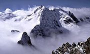
Piz Bernina
Encyclopedia
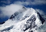
Piz Bernina is the highest mountain
of the Eastern Alps
and the highest point of the Bernina Range
the highest peak in south Rhetic Alps. It is also the farthest easterly mountain higher than 4,000 m in the Alps
, the highest point of the Swiss
canton
of Graubünden
, and the fifth-most prominent peak in the Alps. Piz Bernina is located near St. Moritz
, one of the best known resorts in the Swiss Alps
.
The mountain takes its name from the Bernina Pass
and was given in 1850 by Johann Coaz, who also made the first ascent.
 Piz Bernina is one of the few isolated four-thousander
s in the Alps. It is the culminating point of a group of summits slightly lower than 4000 m mostly lying on the main watershed
between Switzerland
and Italy
(such as Piz Scerscen
, Piz Zupò
and Piz Palü
). The only other summit higher than 4000 m is La Spedla
(the Shoulder), a minor prominence south of the mountain, which is also the highest point on the Italian side of the massif.
The summit itself is located on a perpendicular chain (orientated north–south) starting at La Spedla on the border and finishing at Piz Chalchagn
, composed also of Piz Morteratsch
and Piz Boval
.
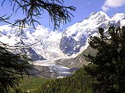
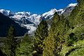
Piz Bernina separates two glacier valleys, the Tschierva Glacier
on the west and the Morteratsch Glacier
on the east. The waters flowing on both side of the mountain end up in the Inn River
running northeast through Engadin
. South of Piz Bernina the watershed separates the drainage basin
s of the Danube
(Black Sea
) and the Po River
(Adriatic Sea
). The summit of Piz Bernina is the culminating point of the Danube drainage basin.
s and gabbro
s. The massif in general is also composed of granite
s (Piz Corvatsch
, Piz Palü
). Most of the range belongs to the Austroalpine nappes
, a tectonic unit whose rocks come from the Apulian plate
, a small continent which broke away from Africa (Gondwana
) before the Alpine orogeny
. The Austroalpine nappes are common in the entire Eastern Alps.
 The first ascent was made via the east ridge in 1850 by the 28-year-old topographer Johann Coaz (from Chur) and his assistants, the brothers Jon and Lorenz Ragut Tscharner. On 13 September 1850, shortly after 6 a.m., they left the Bernina Inn (at 2,050 metres) with their measuring instruments. They traversed the Labyrinth (on the Morteratsch Glacier
) and headed to the Fuorcla Crast'Agüzza, a col between the Crast' Agüzza
and Piz Bernina. They reached the summit at around 6 p.m.
Johan Coaz wrote in his diary:
 In 1866, the south ridge running from La Spedla
was climbed by Francis Fox Tuckett
and F. A. Y. Brown with guides Christian Almer
and F. Andermatten. They started at midnight from the Alpe Foppa on the Italian side, and reached the summit at 11 a.m., descending to Pontresina
only a few hours later.
The first attempt to climb the northern ridge, the Biancograt, was made on 12 August 1876 by H. Cordier and T. Middlemore with guides J. Jaun and C. Maurer. They successfully reached the top of the ridge, Piz Alv
, but when they saw the chasm lying between them and the summit of Piz Bernina, they considered it to be beyond their powers and returned down the Biancograt. Cordier later declared the gap to be "absolutely impossible".
Exactly two years later, Paul Güssfeldt
, accompanied by the guides H. Grass and J. Gross, reached the summit via the Biancograt and accomplished the first complete ascent on this route. The first winter ascent was made on 15 March 1929 by C. Colmus with guides C. and U. Grass. To win a bet
worth 200 CHF, Hermann Buhl
reached the summit of Piz Bernina from the Boval hut in 6 hours; he then descended the north ridge in only 15 minutes, establishing a record.
 Piz Bernina is the highest summit of the Engadin
region and lies close to the resorts of St. Moritz and Pontresina. The mountain can be seen from different viewpoints with the use of ski-lifts from Diavolezza
, Piz Corvatsch
or Piz Nair
. The Bernina Express
train connects St. Moritz with the southern Val Poschiavo through the Bernina Pass
.
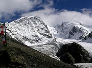
 The normal route starts from the Rifugio Marco e Rosa, located at 3,600 m above the Fuorcla Crast'Agüzza, and follows the route taken by the first ascentionists.
The north ridge, called the Biancograt or Crast Alva (both meaning White Ridge), is the most well-known and attractive route to the summit, and is much more difficult than the normal route. The route starts from the Tschierva Hut
(2,584 m) in Val Roseg, accessible from Pontresina
. The Biancograt itself starts at the Fuorcla Prievlusa (3,430 m) and leads to Piz Alv
(3,995 m). To reach the summit, the Bernina gap – which repulsed Cordier, Middlemore, Jaun and Maurer in 1876 – has to be traversed.
Other huts in the area
Mountain
Image:Himalaya_annotated.jpg|thumb|right|The Himalayan mountain range with Mount Everestrect 58 14 160 49 Chomo Lonzorect 200 28 335 52 Makalurect 378 24 566 45 Mount Everestrect 188 581 920 656 Tibetan Plateaurect 250 406 340 427 Rong River...
of the Eastern Alps
Eastern Alps
Eastern Alps is the name given to the eastern half of the Alps, usually defined as the area east of the Splügen Pass in eastern Switzerland. North of the Splügen Pass, the Posterior Rhine forms the border, and south of the pass, the Liro river and Lake Como form the boundary line.-Geography:The...
and the highest point of the Bernina Range
Bernina Range
The Bernina Range is a mountain range in the Alps of eastern Switzerland and northern Italy. It is considered to be part of the Central Eastern Alps. It is one of the highest ranges of the Alps, covered with many glaciers. Piz Bernina , its highest peak, is the most easterly four thousand-metre...
the highest peak in south Rhetic Alps. It is also the farthest easterly mountain higher than 4,000 m in the Alps
Alps
The Alps is one of the great mountain range systems of Europe, stretching from Austria and Slovenia in the east through Italy, Switzerland, Liechtenstein and Germany to France in the west....
, the highest point of the Swiss
Switzerland
Switzerland name of one of the Swiss cantons. ; ; ; or ), in its full name the Swiss Confederation , is a federal republic consisting of 26 cantons, with Bern as the seat of the federal authorities. The country is situated in Western Europe,Or Central Europe depending on the definition....
canton
Cantons of Switzerland
The 26 cantons of Switzerland are the member states of the federal state of Switzerland. Each canton was a fully sovereign state with its own borders, army and currency from the Treaty of Westphalia until the establishment of the Swiss federal state in 1848...
of Graubünden
Graubünden
Graubünden or Grisons is the largest and easternmost canton of Switzerland. The canton shares borders with the cantons of Ticino, Uri, Glarus and St. Gallen and international borders with Italy, Austria and Liechtenstein...
, and the fifth-most prominent peak in the Alps. Piz Bernina is located near St. Moritz
St. Moritz
St. Moritz is a resort town in the Engadine valley in Switzerland. It is a municipality in the district of Maloja in the Swiss canton of Graubünden...
, one of the best known resorts in the Swiss Alps
Swiss Alps
The Swiss Alps are the portion of the Alps mountain range that lies within Switzerland. Because of their central position within the entire Alpine range, they are also known as the Central Alps....
.
The mountain takes its name from the Bernina Pass
Bernina Pass
The Bernina Pass is a high mountain pass in the Bernina Range of the Alps, in the canton of Graubünden in eastern Switzerland. It connects the famous resort town of St. Moritz in the Engadin valley with the Italian-speaking Val Poschiavo, which ends in the Italian town of Tirano in Valtellina....
and was given in 1850 by Johann Coaz, who also made the first ascent.
Geography
Four-thousander
A four-thousander is a mountain summit that is at least 4,000 metres above sea level. Because the highest peaks in Europe fall into this category, the summits of four-thousanders are popular in Europe with climbers and mountaineers as climbing goals...
s in the Alps. It is the culminating point of a group of summits slightly lower than 4000 m mostly lying on the main watershed
Main chain of the Alps
The Alpine divide is the central line of mountains that forms the water divide of the range. Main chains of mountain ranges are traditionally designated in this way, and generally include the highest peaks of a range; the Alps are something of an unusual case in that several significant groups of...
between Switzerland
Switzerland
Switzerland name of one of the Swiss cantons. ; ; ; or ), in its full name the Swiss Confederation , is a federal republic consisting of 26 cantons, with Bern as the seat of the federal authorities. The country is situated in Western Europe,Or Central Europe depending on the definition....
and Italy
Italy
Italy , officially the Italian Republic languages]] under the European Charter for Regional or Minority Languages. In each of these, Italy's official name is as follows:;;;;;;;;), is a unitary parliamentary republic in South-Central Europe. To the north it borders France, Switzerland, Austria and...
(such as Piz Scerscen
Piz Scerscen
Piz Scerscen is a mountain in the Bernina Range in Switzerland and Italy, joining the neighbouring Piz Bernina by its north-east ridge via a 3,895 m pass...
, Piz Zupò
Piz Zupò
Piz Zupò is a mountain in the Bernina Range in Switzerland and Italy, and is the second highest peak in the range after Piz Bernina.The first ascent of the mountain was made by L. Enderlin and Serardi, with Badrutt on 9 July 1863....
and Piz Palü
Piz Palü
Piz Palü is a mountain in the Bernina Range in Switzerland and Italy. There are three summits on its main ridge, which runs from east to west...
). The only other summit higher than 4000 m is La Spedla
La Spedla
La Spedla is a minor summit south of Piz Bernina on the border between Italy and Switzerland. Because of its small prominence it was included in the enlarged list of alpine four-thousanders.- External links :*...
(the Shoulder), a minor prominence south of the mountain, which is also the highest point on the Italian side of the massif.
The summit itself is located on a perpendicular chain (orientated north–south) starting at La Spedla on the border and finishing at Piz Chalchagn
Piz Chalchagn
The Piz Chalchagn is a mountain in the Bernina Range , located in Graubünden, Switzerland.-External links:*...
, composed also of Piz Morteratsch
Piz Morteratsch
Piz Morteratsch is a mountain in the Bernina Range in Switzerland. It is bordered on the east by the Morteratsch Glacier and on the south-west by the Tschierva Glacier....
and Piz Boval
Piz Boval
The Piz Boval is a mountain in the Bernina Range , located in Graubünden, Switzerland.-External links:*...
.
Piz Bernina separates two glacier valleys, the Tschierva Glacier
Tschierva Glacier
The Tschierva Glacier is a 4 km long glacier situated in the Bernina Range in the canton of Graubünden/Grisons in Switzerland. In 1973 it had an area of 6.2 km².-External links:*...
on the west and the Morteratsch Glacier
Morteratsch Glacier
The Morteratsch Glacier is the largest glacier by area in the Bernina Range of the Bündner Alps in Switzerland....
on the east. The waters flowing on both side of the mountain end up in the Inn River
Inn River
The Inn is a river in Switzerland, Austria and Germany. It is a right tributary of the Danube and is approximately 500km long. The highest point of its drainage basin is the summit of Piz Bernina, at 4,049 metres.- Geography :...
running northeast through Engadin
Engadin
The Engadin or Engadine is a long valley in the Swiss Alps located in the canton of Graubünden in southeast Switzerland. It follows the route of the Inn River from its headwaters at Maloja Pass running northeast until the Inn flows into Austria one hundred kilometers downstream...
. South of Piz Bernina the watershed separates the drainage basin
Drainage basin
A drainage basin is an extent or an area of land where surface water from rain and melting snow or ice converges to a single point, usually the exit of the basin, where the waters join another waterbody, such as a river, lake, reservoir, estuary, wetland, sea, or ocean...
s of the Danube
Danube
The Danube is a river in the Central Europe and the Europe's second longest river after the Volga. It is classified as an international waterway....
(Black Sea
Black Sea
The Black Sea is bounded by Europe, Anatolia and the Caucasus and is ultimately connected to the Atlantic Ocean via the Mediterranean and the Aegean seas and various straits. The Bosphorus strait connects it to the Sea of Marmara, and the strait of the Dardanelles connects that sea to the Aegean...
) and the Po River
Po River
The Po |Ligurian]]: Bodincus or Bodencus) is a river that flows either or – considering the length of the Maira, a right bank tributary – eastward across northern Italy, from a spring seeping from a stony hillside at Pian del Re, a flat place at the head of the Val Po under the northwest face...
(Adriatic Sea
Adriatic Sea
The Adriatic Sea is a body of water separating the Italian Peninsula from the Balkan peninsula, and the system of the Apennine Mountains from that of the Dinaric Alps and adjacent ranges...
). The summit of Piz Bernina is the culminating point of the Danube drainage basin.
Geology
The rocks composing Piz Bernina are dioriteDiorite
Diorite is a grey to dark grey intermediate intrusive igneous rock composed principally of plagioclase feldspar , biotite, hornblende, and/or pyroxene. It may contain small amounts of quartz, microcline and olivine. Zircon, apatite, sphene, magnetite, ilmenite and sulfides occur as accessory...
s and gabbro
Gabbro
Gabbro refers to a large group of dark, coarse-grained, intrusive mafic igneous rocks chemically equivalent to basalt. The rocks are plutonic, formed when molten magma is trapped beneath the Earth's surface and cools into a crystalline mass....
s. The massif in general is also composed of granite
Granite
Granite is a common and widely occurring type of intrusive, felsic, igneous rock. Granite usually has a medium- to coarse-grained texture. Occasionally some individual crystals are larger than the groundmass, in which case the texture is known as porphyritic. A granitic rock with a porphyritic...
s (Piz Corvatsch
Piz Corvatsch
Piz Corvatsch is a mountain in the Bernina Range in Switzerland. A minor summit, Piz Murtel , lies just above the cable car station .-Weather:- References :...
, Piz Palü
Piz Palü
Piz Palü is a mountain in the Bernina Range in Switzerland and Italy. There are three summits on its main ridge, which runs from east to west...
). Most of the range belongs to the Austroalpine nappes
Austroalpine nappes
The Austroalpine nappes are a geological nappe stack in the European Alps. The Alps contain three such stacks, of which the Austroalpine nappes are structurally on top of the other two...
, a tectonic unit whose rocks come from the Apulian plate
Apulian Plate
The Adriatic or Apulian Plate is a small tectonic plate carrying primarily continental crust that broke away from the African plate along a large transform fault in the Cretaceous period. The name Adriatic Plate is usually used when referring to the northern part of the plate...
, a small continent which broke away from Africa (Gondwana
Gondwana
In paleogeography, Gondwana , originally Gondwanaland, was the southernmost of two supercontinents that later became parts of the Pangaea supercontinent. It existed from approximately 510 to 180 million years ago . Gondwana is believed to have sutured between ca. 570 and 510 Mya,...
) before the Alpine orogeny
Orogeny
Orogeny refers to forces and events leading to a severe structural deformation of the Earth's crust due to the engagement of tectonic plates. Response to such engagement results in the formation of long tracts of highly deformed rock called orogens or orogenic belts...
. The Austroalpine nappes are common in the entire Eastern Alps.
Climbing history
Morteratsch Glacier
The Morteratsch Glacier is the largest glacier by area in the Bernina Range of the Bündner Alps in Switzerland....
) and headed to the Fuorcla Crast'Agüzza, a col between the Crast' Agüzza
Crast' Agüzza
Crast' Agüzza is a mountain in the Bernina Range in Italy and Switzerland.The peak is bounded to the north by the Morteratsch Glacier and to the south by the Upper Scerscen Glacier...
and Piz Bernina. They reached the summit at around 6 p.m.
Johan Coaz wrote in his diary:
- "At 6 p.m. we stood on the ardently desired lofty peak. On soil that no human had trodden upon before. On the highest point of the canton at 4052 meters above sea level."
- "Serious thoughts took hold of us. Greedy eyes surveyed the land up to the distant horizon, and thousands and thousands of mountain peaks surrounded us, rising as rocks from the glittering sea of ice. We stared amazed and awe-struck across this magnificent mountain world."
La Spedla
La Spedla is a minor summit south of Piz Bernina on the border between Italy and Switzerland. Because of its small prominence it was included in the enlarged list of alpine four-thousanders.- External links :*...
was climbed by Francis Fox Tuckett
Francis Fox Tuckett
Francis Fox Tuckett FRGS was an English mountaineer. He was vice-president of the Alpine Club from 1866 to 1868, and a Fellow of the Royal Geographical Society.-Life and family:...
and F. A. Y. Brown with guides Christian Almer
Christian Almer
thumb|220px|Christian AlmerChristian Almer was a Swiss mountain guide and the first ascentionist of many prominent mountains in the western Alps during the golden and silver ages of alpinism....
and F. Andermatten. They started at midnight from the Alpe Foppa on the Italian side, and reached the summit at 11 a.m., descending to Pontresina
Pontresina
Pontresina is a municipality in the district of Maloja in the canton of Graubünden in Switzerland.-History and name:The city was first mentioned in medieval Latin documents as pontem sarasinam in 1137. In 1237 it was mentioned as de Ponte Sarraceno and in 1303 as ponte sarracino...
only a few hours later.
The first attempt to climb the northern ridge, the Biancograt, was made on 12 August 1876 by H. Cordier and T. Middlemore with guides J. Jaun and C. Maurer. They successfully reached the top of the ridge, Piz Alv
Piz Alv
Piz Alv is a minor summit north of Piz Bernina in the Bernina Range of the Swiss Alps. It is located in the canton of Graubünden.-External links:*...
, but when they saw the chasm lying between them and the summit of Piz Bernina, they considered it to be beyond their powers and returned down the Biancograt. Cordier later declared the gap to be "absolutely impossible".
Exactly two years later, Paul Güssfeldt
Paul Güssfeldt
Dr Paul Güssfeldt was a German geologist, mountaineer and explorer.-Biography:Güssfeldt was born in Berlin, where he also died almost 80 years later...
, accompanied by the guides H. Grass and J. Gross, reached the summit via the Biancograt and accomplished the first complete ascent on this route. The first winter ascent was made on 15 March 1929 by C. Colmus with guides C. and U. Grass. To win a bet
Bet
Bet or BET may refer to:* A wager in gambling* Basic Economics Test * Bet , the second letter in many Semitic alphabets, including Aramaic, Hebrew, Phoenician and Syriac* Brunauer-Emmett-Teller isotherm. See BET_theory...
worth 200 CHF, Hermann Buhl
Hermann Buhl
Hermann Buhl is considered one of the best climbers of all time. He was particularly innovative in applying alpine style to Himalayan climbing...
reached the summit of Piz Bernina from the Boval hut in 6 hours; he then descended the north ridge in only 15 minutes, establishing a record.
Tourism
Engadin
The Engadin or Engadine is a long valley in the Swiss Alps located in the canton of Graubünden in southeast Switzerland. It follows the route of the Inn River from its headwaters at Maloja Pass running northeast until the Inn flows into Austria one hundred kilometers downstream...
region and lies close to the resorts of St. Moritz and Pontresina. The mountain can be seen from different viewpoints with the use of ski-lifts from Diavolezza
Diavolezza
The Diavolezza is a mountain in the area of Pontresina in Graubünden. It has a height of 2978 m and is located southeast of Munt Pers ....
, Piz Corvatsch
Piz Corvatsch
Piz Corvatsch is a mountain in the Bernina Range in Switzerland. A minor summit, Piz Murtel , lies just above the cable car station .-Weather:- References :...
or Piz Nair
Piz Nair
Piz Nair is a mountain above St. Moritz in the Albula Range in Switzerland. The summit is easily accessible from the village with a funicular and an aerial tramway. The mountain hosted the alpine skiing events for the 1948 Winter Olympics in neighboring St. Moritz.-External links:*...
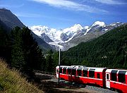
. The Bernina Express
Bernina Express
The Bernina Express is an express train connecting Chur in Switzerland with Poschiavo and Tirano in Italy, by crossing the Swiss Alps from north to south. For most of its journey, the train also passes along and through the World Heritage Site known as the Rhaetian Railway in the Albula / Bernina...
train connects St. Moritz with the southern Val Poschiavo through the Bernina Pass
Bernina Pass
The Bernina Pass is a high mountain pass in the Bernina Range of the Alps, in the canton of Graubünden in eastern Switzerland. It connects the famous resort town of St. Moritz in the Engadin valley with the Italian-speaking Val Poschiavo, which ends in the Italian town of Tirano in Valtellina....
.
Climbing routes and huts
The north ridge, called the Biancograt or Crast Alva (both meaning White Ridge), is the most well-known and attractive route to the summit, and is much more difficult than the normal route. The route starts from the Tschierva Hut
Tschierva Hut
The Tschierva Hut is a mountain hut located in the Swiss canton of Graubünden at the foot of Piz Bernina, Piz Tschierva and Piz Morteratsch at the end of Val Roseg. The hut lies at 2,584 metres above sea level near the Tschierva Glacier and can be accessed from Pontresina via a trail...
(2,584 m) in Val Roseg, accessible from Pontresina
Pontresina
Pontresina is a municipality in the district of Maloja in the canton of Graubünden in Switzerland.-History and name:The city was first mentioned in medieval Latin documents as pontem sarasinam in 1137. In 1237 it was mentioned as de Ponte Sarraceno and in 1303 as ponte sarracino...
. The Biancograt itself starts at the Fuorcla Prievlusa (3,430 m) and leads to Piz Alv
Piz Alv
Piz Alv is a minor summit north of Piz Bernina in the Bernina Range of the Swiss Alps. It is located in the canton of Graubünden.-External links:*...
(3,995 m). To reach the summit, the Bernina gap – which repulsed Cordier, Middlemore, Jaun and Maurer in 1876 – has to be traversed.
Other huts in the area
- Rifugio Carate Brianza (2,662 m) – capacity 32 beds, 3 places in winter room
- Rifugio Marinelli Bombardieri (2,813 m) – capacity 220 beds, 15 places in winter room
- Chamanna Boval (2,495 m) – capacity 120 beds
- Chamanna da DiavolezzaDiavolezzaThe Diavolezza is a mountain in the area of Pontresina in Graubünden. It has a height of 2978 m and is located southeast of Munt Pers ....
(2,973 m) – capacity 234 beds - Chamana Boval (2,583 m) - capacity 100 beds
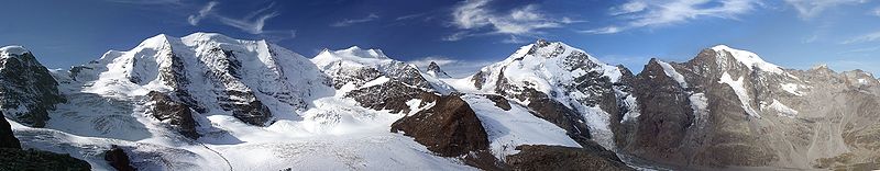
Panorama
External links
- Piz Bernina on SummitPost
- Italian route account – Czech/English