

Hong Kong National Geopark
Encyclopedia
New Territories
New Territories is one of the three main regions of Hong Kong, alongside Hong Kong Island and the Kowloon Peninsula. It makes up 86.2% of Hong Kong's territory. Historically, it is the region described in The Convention for the Extension of Hong Kong Territory...
. It includes eight sites (and combinations of sites). On September 18, 2011, UNESCO
UNESCO
The United Nations Educational, Scientific and Cultural Organization is a specialized agency of the United Nations...
listed the Geopark as part of its Global Geoparks Network.
Hong Kong Geopark is made up of eight Geo-Areas distributed across the Sai Kung Volcanic
Rock Region and Northeast New Territories Sedimentary Rock Region.
- Sai KungSai Kung DistrictSai Kung District is the second largest district in Hong Kong in terms of area. It comprises the southern half of Sai Kung Peninsula and Clear Water Bay Peninsula in the New Territories plus a strip to the east of Kowloon. The administrative centre is Sai Kung Town but the district's population is...
Volcanic Rock Region- High IslandHigh Island, Hong KongHigh Island or Leung Shuen Wan is a former island in the southeast of Sai Kung Peninsula, Hong Kong. The island was connected to the peninsula by two dams to enclose the Kwun Mun Channel and form the High Island Reservoir. The construction of the dam spanned 10 years from 1969 to 1979...
and High Island ReservoirHigh Island ReservoirThe High Island Reservoir , located in the far south eastern part of the Sai Kung Peninsula, was opened in 1978 helping to alleviate water shortage problems in Hong Kong. Its water capacity is approximately 273 million cubic metres... - Ung Kong Group (甕缸群島): Wang ChauWang Chau (Sai Kung)Wang Chau is an island of Hong Kong. Administratively it is part of Sai Kung District.Together with Basalt Island and Bluff Island, it forms the Ung Kong Group and is part of Hong Kong National Geopark.-External links:*...
, Basalt IslandBasalt IslandBasalt Island is an island of Hong Kong. Administratively it is part of Sai Kung District. Together with Wang Chau and Bluff Island, it forms the Ung Kong Group and is part of Hong Kong National Geopark.-History:...
and Bluff IslandBluff IslandBluff Island, indigneously known as Sha Tong Hau Shan , also known as Ung Kong , is an island in Port Shelter, south of Sai Kung Peninsula of Hong Kong. It is an important area for corals and other marine life. The island is zoned as Site of Special Scientific Interest in 1979... - Ninepin GroupNinepin GroupThe Ninepin Group or Kwo Chau Islands is a group of 29 islands in the easternmost waters of Hong Kong. The Ninepin Group falls under the jurisdiction of Sai Kung District of Hong Kong.-Islands:The islands of the group include:...
- Sharp IslandSharp IslandSharp Island is one of the largest islands in the Kiu Tsui Country Park located at Port Shelter of Sai Kung, Hong Kong. Tourists can go there for BBQ activities, fishing, swimming as well as diving....
- High Island
- Northeast New Territories Sedimentary Rock Region
- Double HavenDouble HavenDouble Haven or Yan Chau Tong is a harbour hugged by Double Island, Crescent Island and Crooked Island with north-eastern New Territories of Hong Kong. Major parts of the haven falls within Yan Chau Tong Marine Park to protect the wildlife of the marine creatures. It is renowned for its scenery...
- North and south coasts of Tolo ChannelTolo ChannelTolo Channel or Chek Mun Hoi Hap is a channel south of Plover Cove in Hong Kong connecting Tolo Harbour to Mirs Bay. At Mirs Bay end, it is named North Channel....
. The Geo-Area includes the north shore of Tolo Channel, Ma Shi ChauMa Shi ChauMa Shi Chau is an island of Hong Kong, under the administration of Tai Po District. It is located in Tolo Harbour in the northeast New Territories . It is connected with another island, Yim Tin Tsai, by a narrow strip of land that is only accessible when the tide is low.-Geography:Ma Shi Chau has...
on the southwest shore and Lai Chi ChongLai Chi ChongLai Chi Chong is a village and an area of Hong Kong, located on the southeastern shore of Tolo Channel, and on the northern shore of the Sai Kung Peninsula, in the Eastern New Territories. Administratively, it is part of Tai Po District....
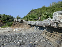
on the south shore. Most of the rocks along the north shore of Tolo Channel and at Bluff Head are the oldest in Hong Kong, formed about 400 million years ago during the Devonian Period. - Port IslandChek ChauPort Island is an island of Hong Kong, under the administration of Tai Po District. It is located in Tolo Channel, in the northeastern New Territories...
— Bluff Head (Wong Chuk Kok Tsui) - Tung Ping ChauPing ChauPing Chau is an island in Hong Kong. It is also known as Tung Ping Chau . Tung is prepended to the name so as to avoid possible confusion with Peng Chau, another island in Hong Kong with an identically pronounced name in the Cantonese language...
- Double Haven
See also
- Geology of Hong KongGeology of Hong KongThe geology of Hong Kong is dominated by Mesozoic volanic and granitic rocks, which together make up about 85% of the total land area. The remaining area is underlain by Palaeozoic meta-sedimentary rocks, Mesozoic to Cenozoic sedimentary rocks and superficial deposits.-External links:***...
- Conservation in Hong Kong
- Protected areas of China
- List of National Geoparks