
Phu Kradung National Park
Encyclopedia
Phu Kradueng National Park , located in Amphoe Phu Kradueng
of Loei Province
, is one of the most famous national parks of Thailand
, with a high point of 1316 m (4318 ft) above sea level. Every year tens of thousands of people come to make the climb up this famous mountain. It received the title of a nationally protected forest in the year 1943, and was proclaimed a national park
on the 7th of October 1959, the second national park of Thailand
after Khao Yai National Park
.
The park is closed to visitors during the rainy season (01 June - 30 September).
and Cretaceous
sandstone
formations, takes the form of a mesa
towering some 1000 meters above the surrounding valleys. The summit plateau
is roughly square-shaped and 60 km² in size, with an average elevation of about 1250 meters. Sloping slightly to the north, its western, southern and eastern edges are fairly straight and formed by abrupt sandstone cliff
s, while the northern part is dissected into a more irregular shape, containing a number of streams and (seasonal) waterfall
s. The summit itself, located in the southwestern part of the plateau, is inconspicuous.
forest tiers, namely (in ascending order): Deciduous
Dipterocarp
, Mixed Deciduous, Dry Evergreen
, and Hill Evergreen Forests, interspersed with bamboo
. In contrast to that, the plateau at the mountain top consists of a sandy pine
savanna
landscape.
.
The beauty of the mountain is reflected in local folk tales. One person named Phran, who fled from another village, believed that Phu Kradueng had never been climbed before. He led his bull to the top of the mountain. He found it full of beautiful deer, and pine forests. There were many different types of plants, trees and wild animals. After this he stayed, and lived his life surrounded by the beauty of the mountain.
Nowadays, Phu Kradueng is extremely popular with young Thais, particularly university students. Accommodation on the mountain itself is limited to a "tent city" with hundreds of canvas tents available for rent. The sense of isolation and scenic beauty is further spoilt by annoying and unnecessary loudspeakers intermittently announcing food availability, sleeping hours, and other concerns in Thai.
to Pha Nok Kao. Get off in front of Ran Je Gim (ร้านเจ๊กิม). From there a minibus is available to take you to the central office of the park. The minibus takes approximately half an hour. The park office closes at 15:00, as climbers will not have enough time to climb the mountain before dark.
The last 1300 metres from Sam Khrae to the top is the hardest and steepest part of the hike. There are ladders and ramps at parts where it would otherwise be impossible to walk. Once reaching the highest point of the trail (1288 m elevation) at the edge of the summit plateau, it is still a 3.6 kilometre walk over flat terrain to the Wang Kwang visitor center and campsite, where tents and lodging buildings are available.
Many climbers hire porters to carry their belongings to the top of the mountain for them. As a result, the main trail is often crowded with long lines of porters and following climbers.
. This is a new trail, to open in 2005. There aren't as yet any places to stop and purchase food and drinks on the way up on this trail.
Amphoe Phu Kradueng
Phu Kradueng is a district of Loei Province, northeastern Thailand.-Geography:Neighboring districts are Phu Luang, Nong Hin and Pha Kao of Loei Province, Si Bun Rueang of Nongbua Lamphu Province, Si Chomphu, Chum Phae and Phu Pha Man of Khon Kaen Province, and Nam Nao of Phetchabun Province.Phu...
of Loei Province
Loei Province
Loei is one of the most sparsely populated provinces of Thailand, located in the North-East. Neighboring provinces are Nong Khai, Udon Thani, Nongbua Lamphu, Khon Kaen, Phetchabun, Phitsanulok...
, is one of the most famous national parks of Thailand
Thailand
Thailand , officially the Kingdom of Thailand , formerly known as Siam , is a country located at the centre of the Indochina peninsula and Southeast Asia. It is bordered to the north by Burma and Laos, to the east by Laos and Cambodia, to the south by the Gulf of Thailand and Malaysia, and to the...
, with a high point of 1316 m (4318 ft) above sea level. Every year tens of thousands of people come to make the climb up this famous mountain. It received the title of a nationally protected forest in the year 1943, and was proclaimed a national park
National park
A national park is a reserve of natural, semi-natural, or developed land that a sovereign state declares or owns. Although individual nations designate their own national parks differently A national park is a reserve of natural, semi-natural, or developed land that a sovereign state declares or...
on the 7th of October 1959, the second national park of Thailand
Thailand
Thailand , officially the Kingdom of Thailand , formerly known as Siam , is a country located at the centre of the Indochina peninsula and Southeast Asia. It is bordered to the north by Burma and Laos, to the east by Laos and Cambodia, to the south by the Gulf of Thailand and Malaysia, and to the...
after Khao Yai National Park
Khao Yai National Park
Khao Yai National Park is a national park in Thailand.-Description:Khao Yai National Park is situated in the Sankamphaeng Mountain Range, the southern prolongation of the Dong Phaya Yen Mountains, at the southwestern boundary of the Khorat Plateau....
.
The park is closed to visitors during the rainy season (01 June - 30 September).
Topography
Phu Kradueng mountain, made up of JurassicJurassic
The Jurassic is a geologic period and system that extends from about Mya to Mya, that is, from the end of the Triassic to the beginning of the Cretaceous. The Jurassic constitutes the middle period of the Mesozoic era, also known as the age of reptiles. The start of the period is marked by...
and Cretaceous
Cretaceous
The Cretaceous , derived from the Latin "creta" , usually abbreviated K for its German translation Kreide , is a geologic period and system from circa to million years ago. In the geologic timescale, the Cretaceous follows the Jurassic period and is followed by the Paleogene period of the...
sandstone
Sandstone
Sandstone is a sedimentary rock composed mainly of sand-sized minerals or rock grains.Most sandstone is composed of quartz and/or feldspar because these are the most common minerals in the Earth's crust. Like sand, sandstone may be any colour, but the most common colours are tan, brown, yellow,...
formations, takes the form of a mesa
Mesa
A mesa or table mountain is an elevated area of land with a flat top and sides that are usually steep cliffs. It takes its name from its characteristic table-top shape....
towering some 1000 meters above the surrounding valleys. The summit plateau
Plateau
In geology and earth science, a plateau , also called a high plain or tableland, is an area of highland, usually consisting of relatively flat terrain. A highly eroded plateau is called a dissected plateau...
is roughly square-shaped and 60 km² in size, with an average elevation of about 1250 meters. Sloping slightly to the north, its western, southern and eastern edges are fairly straight and formed by abrupt sandstone cliff
Cliff
In geography and geology, a cliff is a significant vertical, or near vertical, rock exposure. Cliffs are formed as erosion landforms due to the processes of erosion and weathering that produce them. Cliffs are common on coasts, in mountainous areas, escarpments and along rivers. Cliffs are usually...
s, while the northern part is dissected into a more irregular shape, containing a number of streams and (seasonal) waterfall
Waterfall
A waterfall is a place where flowing water rapidly drops in elevation as it flows over a steep region or a cliff.-Formation:Waterfalls are commonly formed when a river is young. At these times the channel is often narrow and deep. When the river courses over resistant bedrock, erosion happens...
s. The summit itself, located in the southwestern part of the plateau, is inconspicuous.
Vegetation
The mountain's steep sides are home to a succession of tropicalTropics
The tropics is a region of the Earth surrounding the Equator. It is limited in latitude by the Tropic of Cancer in the northern hemisphere at approximately N and the Tropic of Capricorn in the southern hemisphere at S; these latitudes correspond to the axial tilt of the Earth...
forest tiers, namely (in ascending order): Deciduous
Deciduous
Deciduous means "falling off at maturity" or "tending to fall off", and is typically used in reference to trees or shrubs that lose their leaves seasonally, and to the shedding of other plant structures such as petals after flowering or fruit when ripe...
Dipterocarp
Dipterocarpaceae
Dipterocarpaceae is a family of 17 genera and approximately 500 species of mainly tropical lowland rainforest trees. The family name, from the type genus Dipterocarpus, is derived from Greek and refers to the two-winged fruit...
, Mixed Deciduous, Dry Evergreen
Evergreen
In botany, an evergreen plant is a plant that has leaves in all seasons. This contrasts with deciduous plants, which completely lose their foliage during the winter or dry season.There are many different kinds of evergreen plants, both trees and shrubs...
, and Hill Evergreen Forests, interspersed with bamboo
Bamboo
Bamboo is a group of perennial evergreens in the true grass family Poaceae, subfamily Bambusoideae, tribe Bambuseae. Giant bamboos are the largest members of the grass family....
. In contrast to that, the plateau at the mountain top consists of a sandy pine
Pine
Pines are trees in the genus Pinus ,in the family Pinaceae. They make up the monotypic subfamily Pinoideae. There are about 115 species of pine, although different authorities accept between 105 and 125 species.-Etymology:...
savanna
Savanna
A savanna, or savannah, is a grassland ecosystem characterized by the trees being sufficiently small or widely spaced so that the canopy does not close. The open canopy allows sufficient light to reach the ground to support an unbroken herbaceous layer consisting primarily of C4 grasses.Some...
landscape.
History
Phu (ภู) comes from the Thai word Phukao (ภูเขา), meaning mountain. The name Kradueng (กระดึง), or Krading (กระดิ่ง) in the local dialect of Loei Province, can be translated as Rakhang Yai (ระฆังใหญ่), meaning a large bell. This name comes from a legend relating to a Buddhist holiday. During the holiday many of the towns people heard the sound of a large bell. They believed it to be the bell of IndraIndra
' or is the King of the demi-gods or Devas and Lord of Heaven or Svargaloka in Hindu mythology. He is also the God of War, Storms, and Rainfall.Indra is one of the chief deities in the Rigveda...
.
The beauty of the mountain is reflected in local folk tales. One person named Phran, who fled from another village, believed that Phu Kradueng had never been climbed before. He led his bull to the top of the mountain. He found it full of beautiful deer, and pine forests. There were many different types of plants, trees and wild animals. After this he stayed, and lived his life surrounded by the beauty of the mountain.
Nowadays, Phu Kradueng is extremely popular with young Thais, particularly university students. Accommodation on the mountain itself is limited to a "tent city" with hundreds of canvas tents available for rent. The sense of isolation and scenic beauty is further spoilt by annoying and unnecessary loudspeakers intermittently announcing food availability, sleeping hours, and other concerns in Thai.
Autobus
The easiest route to Phu Kradueng is to take a bus from Khon KaenKhon Kaen
Khon Kaen is a city in Isan, Thailand. It is also the capital of Khon Kaen province and the Khon Kaen district.-Geography and demography:Khon Kaen is located in the Khorat Plateau, in the central-northwestern area of Isaan...
to Pha Nok Kao. Get off in front of Ran Je Gim (ร้านเจ๊กิม). From there a minibus is available to take you to the central office of the park. The minibus takes approximately half an hour. The park office closes at 15:00, as climbers will not have enough time to climb the mountain before dark.
The Main Trail to the top from Amphoe Phu Kradueng
This is a very old and historic trail about 5.5 km in length, climbing the southeastern flank of the mountain. It starts from the main park office in Amphoe Phu Kradueng, at an elevation of about 300 m. There are many places to rest on the way up. These rest plateaus are called Sam (ซำ). At each there are several vendors selling food and drinks, and some provide toilet facilities and/or medical services as well. There are eight of these on the way up. In order of ascent, they are:- Sam Haek (ซำแฮก) - This rest area is located approximately 1000 metres from the starting point, on an intermediate plateau immediately above a very steep section of the trail. Most Thai visitors believe the word haek (แฮก) means "to be out of breath", "to pant", because of its resemblance to the sound made when out of breath. However, the real meaning is sacred or holy object in the local dialect.
- Sam Bon (ซำบอน) - This rest area is approximately 700 metres from Sam Haek.
- Sam Kok Kork (ซำกกกอก) - This rest area is approximately 440 metres from Sam Bon.
- Sam Ko Sang (ซำกอซาง) - This rest area is approximately 200 metres from Sam Kok Kork.
- Sam Kok Wa (ซำกกหว้า) - This rest area is approximately 580 metres from Sam Ko Sang.
- Sam Kok Phai (ซำกกไผ่) - This rest area is approximately 460 metres from Sam Kok Wa.
- Sam Kok Don (ซำกกโดน) - This rest area is approximately 300 metres from Sam Kok Phai.
- Sam Khrae (ซำแคร่) - This rest area is approximately 450 metres from Sam Kok Don.
The last 1300 metres from Sam Khrae to the top is the hardest and steepest part of the hike. There are ladders and ramps at parts where it would otherwise be impossible to walk. Once reaching the highest point of the trail (1288 m elevation) at the edge of the summit plateau, it is still a 3.6 kilometre walk over flat terrain to the Wang Kwang visitor center and campsite, where tents and lodging buildings are available.
Many climbers hire porters to carry their belongings to the top of the mountain for them. As a result, the main trail is often crowded with long lines of porters and following climbers.
Trail to the top from Amphoe Nam Nao
Travelers can climb the mountain from Amphoe Nam NaoAmphoe Nam Nao
Nam Nao is the northeasternmost district of Phetchabun Province, northern Thailand.-History:On November 16, 1978 the tambon Nam Nao and Lak Dan were split from Lom Sak district and made into a minor district...
. This is a new trail, to open in 2005. There aren't as yet any places to stop and purchase food and drinks on the way up on this trail.
Trails at the top of the Mountain
There are many hiking trails to the many cliffs and waterfalls on top of Phu Kradueng. There are two categories of trails on the summit plateau. The first one is the normal trails open to the public, while the second one is the trails in the closed off forest. In the first category, there's a waterfalls trail and a cliffs trail. The closed forest has two areas, named area one and area two.Cliffs Trail
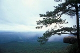
Starting from the visitor center on the mountain, travelers can explore the cliffs trail. There are many cliffs that are known worldwide for their beauty.- Pha Nok Aen Cliff (ผานกแอ่น) - This cliff is located on the east side of the mountain, approximately 1.1 kilometres from the campsite and tourist office. This is an important tourist spot, where many people go to watch the sunrise. In the summer and rainy season, this cliff is above the clouds, creating a beautiful view of the sunrise.
- Pha Mak Duk Cliff (ผาหมากดูก) - This cliff is located on the south side of the mountain. It is located approximately 2 kilometres from the campsite and tourist office. Travelers who have little time come here to watch the sunset, due to its closeness to the campsite.
- Pha Jam Sin Cliff (ผาจำศีล) - Approximately 600 metres from Pha Mak Duk Cliff.
- Pha Na Noi Cliff (ผานาน้อย) - Approximately 600 metres from Pha Jam Sin Cliff.
- Pha Yiap Mek Cliff (ผาเหยียบเมฆ) - Approximately two kilometres from Pha Na Noi Cliff.
- Pha Daeng Cliff (ผาแดง) - Approximately 1.5 kilometres from Pha Yiap Mek Cliff.
- Pha Lom Sak Cliff (ผาหล่มสัก) - Approximately 2.5 kilometres from Pha Daeng Cliff. This cliff is located on the west side of Phu Kradueng mountain. Most people who climb the mountain will go to watch the sunset at this cliff. On a nice clear day, it's possible to see Phu Pha Jit Mountain (ภูผาจิต) of Nam Nao National Park (อุทยาแห่งชาติน้ำหนาว).
Wild Animals Native to Phu Kradueng
- DeerDeerDeer are the ruminant mammals forming the family Cervidae. Species in the Cervidae family include white-tailed deer, elk, moose, red deer, reindeer, fallow deer, roe deer and chital. Male deer of all species and female reindeer grow and shed new antlers each year...
- Travelers who climb to the top of Phu Kradueng will definitely see at least one deer. One group of deer is looked after in the camp site. This allows these deer to not be scared of humans, thus letting the other deer not be bothered by travelers. The first deer's name is Kam La (คำหล้า) which means "the last born". The second deer's name is Kam Pir (คัมภีร์) which means "religious scripture". - Grubs - Small insects that are called Thak (ทาก). These insects are very common to Phu Kradueng beyond the little recognition they receive. Most people don't like these insects, although they are important to Phu Kradueng's environment. There are a lot of these insects during the rainy season. They have made residence in many of the building on Phu Kradueng. There are also many near the waterfalls and in the closed forests. These grubs are similar to those found in Khao Yai National ParkKhao Yai National ParkKhao Yai National Park is a national park in Thailand.-Description:Khao Yai National Park is situated in the Sankamphaeng Mountain Range, the southern prolongation of the Dong Phaya Yen Mountains, at the southwestern boundary of the Khorat Plateau....
or Khao Luang National Park, yet are of bigger size. - Elephants
- Mountain Crabs
Famous Plants and Trees of Phu Kradueng
- Maple TreeMapleAcer is a genus of trees or shrubs commonly known as maple.Maples are variously classified in a family of their own, the Aceraceae, or together with the Hippocastanaceae included in the family Sapindaceae. Modern classifications, including the Angiosperm Phylogeny Group system, favour inclusion in...
or Fai Duean Ha (ไฟเดือนห้า) - The leaves of these trees turn red during the winter season (in Thailand the month of December). If travelers want to be sure that they will see red leaves they can and should phone the park beforehand. - NepenthesNepenthesThe Nepenthes , popularly known as tropical pitcher plants or monkey cups, are a genus of carnivorous plants in the monotypic family Nepenthaceae. The genus comprises roughly 130 species, numerous natural and many cultivated hybrids...
(a genus of pitcher plantPitcher plantPitcher plants are carnivorous plants whose prey-trapping mechanism features a deep cavity filled with liquid known as a pitfall trap. It has been widely assumed that the various sorts of pitfall trap evolved from rolled leaves, with selection pressure favouring more deeply cupped leaves over...
s) - Can be found close to the Pha Na Noi and Pha Daeng cliffs. - Siam TulipSiam TulipThe Siam Tulip or Summer Tulip is a tropical plant native to northern Thailand and Cambodia. Despite its name, it is not related to the tulip, but to the various ginger species such as turmeric...
- This tulip can be found close to Pha Yiap Mek and Pha Daeng cliffs. This flower blooms beautifully annually during the month of April. In the month of May you can still find many of these flowers blooming but insects and other animals will have begun to eat them.