

Dong Phaya Yen mountains
Encyclopedia
Thailand
Thailand , officially the Kingdom of Thailand , formerly known as Siam , is a country located at the centre of the Indochina peninsula and Southeast Asia. It is bordered to the north by Burma and Laos, to the east by Laos and Cambodia, to the south by the Gulf of Thailand and Malaysia, and to the...
.
Description
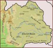
Dong Phaya Yen is the southeastern extension of the Phetchabun mountainsPhetchabun Mountains
The Phetchabun mountains are a mountain range in Thailand.-Geography:It extends in a roughly north-south direction, and separates the broad Chao Phraya river valley of central Thailand from the Khorat Plateau of northeast Thailand...
, dividing the Chao Phraya river valley of Central Thailand and the Khorat Plateau
Khorat Plateau
The Khorat Plateau also Korat Plateau, is a plateau in the northeastern region of Thailand, named for the short form of Nakhon Ratchasima, an historical stronghold controlling access to and from the plateau.-Geography:...
of the northeast. The mountain chain reaches a maximum altitude of 1,351 m above sea level at Khao Rom, its highest hill.
The range has a length of about 230 km. The southern arm of the Dong Phaya Yen Mountains is the Sankamphaeng Range, that merges with the Dângrêk Mountains
Dângrêk Mountains
The Dângrêk Mountains , meaning "Carrying-Pole Mountains" in Khmer, is a mountain range forming a natural border between Cambodia and Thailand....
on its eastern end.
The mountains are drained to the north by several tributaries to the Mun River
Mun River
The Mun River , sometimes spelled Moon River, is a tributary of the Mekong river. It carries approximately 21,000 cubic kilometres of water per year.-Geography:...
, while the south drains into the Prachinburi River.
History
Dong Phaya Yen was once known as Dong Phaya Fai or "Jungle of the Fire Lord" because this area was once the vast forest where malariaMalaria
Malaria is a mosquito-borne infectious disease of humans and other animals caused by eukaryotic protists of the genus Plasmodium. The disease results from the multiplication of Plasmodium parasites within red blood cells, causing symptoms that typically include fever and headache, in severe cases...
killed most travelers who dared to pass through the woods.
Much of the forest cover, however, was destroyed since the beginning of 20th century. Following the deforestation
Deforestation
Deforestation is the removal of a forest or stand of trees where the land is thereafter converted to a nonforest use. Examples of deforestation include conversion of forestland to farms, ranches, or urban use....
of the area, Vice King (Uparaja
Uparaja
Uparaja or Ouparath, also Ouparaja , was a royal title reserved for the vice royal in the Buddhist dynasties in Burma, Cambodia, and Laos and Thailand as well as some of their minor tributary kingdoms.-Burma:...
) Pinklao
Pinklao
Phrabat Somdet Phra Pinklao Chaoyuhua was the younger brother of King Mongkut and the Second King of Siam, who crowned him as a monarch with equal honor to himself.-Early life:...
changed the name of the forest from Dong Phaya Fai to Dong Phaya Yen to imply that "the wild forest has been tamed".
Protected areas
Several national parks are located in the mountains. The most famous one is the Khao Yai National ParkKhao Yai National Park
Khao Yai National Park is a national park in Thailand.-Description:Khao Yai National Park is situated in the Sankamphaeng Mountain Range, the southern prolongation of the Dong Phaya Yen Mountains, at the southwestern boundary of the Khorat Plateau....
, which was the first national park of Thailand. Other parks are the Ta Phraya National Park at the boundary with Cambodia
Cambodia
Cambodia , officially known as the Kingdom of Cambodia, is a country located in the southern portion of the Indochina Peninsula in Southeast Asia...
, the Thap Lan National Park
Thap Lan National Park
Thap Lan National Park is located in Prachinburi Province, Thailand. Established as a national park on December 23, 1981, it was the country's 40th...
, Pang Sida National Park
Pang Sida National Park
Pang Sida National Park is a national park in the Sankamphaeng Range, covering almost 600 square kilometres in the eastern Thai province of Sa Kaeo. It is 28 kilometres north of Sa Kaeo City, the capital of the province.-Getting There:...
, Phra Phutthachai National Park and the Dongyai Wildlife Sanctuary.
Altogether 6155 km² are protected in these parks.
In 2005 the forests of the Dong Phaya Yen mountains were inscribed on the UNESCO
UNESCO
The United Nations Educational, Scientific and Cultural Organization is a specialized agency of the United Nations...
World Heritage List under the name Dong Phaya Yen – Khao Yai Forest Complex.