

Pennsylvania Route 3
Encyclopedia
Pennsylvania Route 3 is a state highway
located in the southeastern portion of Pennsylvania
. The route connects West Chester
with Philadelphia
. The divided highway
that comprises much of its route is the West Chester Pike, built as a turnpike
by the Philadelphia and West Chester Turnpike Company. In the early 20th century, it comprised part of the Lakes-to-Sea Highway
.
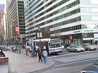
From 1898 to 1954, the route was paralleled by a streetcar line of the Philadelphia Suburban Transportation Company. However, the line was removed in order to facilitate a four-lane widening of the entire length of the highway in response to traffic and safety concerns. Today, SEPTA's Route 104
bus covers most of the length of the route, running from West Chester
to 69th Street Terminal
in Upper Darby.
in West Chester
, as a one-way pair
of Market and Gay Streets. At the borough line, the route becomes West Chester Pike, a four-lane divided highway
. The route interchanges with the US 202
/US 322
bypass of West Chester, heading eastwards towards Goshen
and the county line.
PA 3 continues eastward through Edgmont
, passing by Ridley Creek State Park
. It passes through Newtown Square and Broomall
, interchanging with Interstate 476
near Havertown
, where it also meets U.S. 1
. In the Philadelphia inner suburb of Upper Darby, the West Chester Pike ends and the route continues as Market Street
across the Philadelphia city limits.
PA 3 enters Philadelphia as Market Street, then immediately turns onto the Cobbs Creek Parkway and divides into Chestnut
and Walnut
Streets. In the University City
neighborhood of Philadelphia, the route makes several turns including a short overlap with U.S. Route 13
, with the westbound direction becoming J.F.K.
Boulevard and the eastbound direction turning back onto Market Street, and across the Market Street Bridge
. Both streets pass over I-76
and the Schuylkill River
at 30th Street Station
, and the westbound boulevard passes the Comcast Center
, Pennsylvania's tallest skyscraper. The route then ends at Pennsylvania Route 611
in a massive traffic circle
around Philadelphia City Hall
.
 The Philadelphia and West Chester Turnpike Road Company was formed in 1848 to build a toll road
between the two cities. The road was one of several built in Delaware County in the 1840s, as part of a plan to improve the farming and manufacturing business in the county. Rail was first used on the turnpike in 1858, when the Delaware County Passenger Rail Road Company built a 4 miles (6.4 km) line from 39th and Market streets in Philadelphia to Howard House.
In 1924, PA 3 was first signed onto the William Penn Highway
, from the West Virginia
state line to the New Jersey state line
. It was designated on what is today U.S. Route 22
, from the West Virginia state line to Harrisburg; U.S. Route 322
from Harrisburg to Hershey; U.S. Route 422
from Hershey to Reading
; U.S. Route 222 from Reading to Allentown; US 22 from Allentown to the New Jersey state line. The number was decommissioned in 1930, four years after AASHTO added the US 22 designation.
In 1927, a portion of the Lakes-to-Sea Highway
(PA 5) was signed to the West Chester Pike. By 1940, PA 3 was commissioned replacing the previous PA 5 designation.
State highway
State highway, state road or state route can refer to one of three related concepts, two of them related to a state or provincial government in a country that is divided into states or provinces :#A...
located in the southeastern portion of Pennsylvania
Pennsylvania
The Commonwealth of Pennsylvania is a U.S. state that is located in the Northeastern and Mid-Atlantic regions of the United States. The state borders Delaware and Maryland to the south, West Virginia to the southwest, Ohio to the west, New York and Ontario, Canada, to the north, and New Jersey to...
. The route connects West Chester
West Chester, Pennsylvania
The Borough of West Chester is the county seat of Chester County, Pennsylvania, United States. The population was 18,461 at the 2010 census.Valley Forge, the Brandywine Battlefield, Longwood Gardens, Marsh Creek State Park, and other historical attractions are near West Chester...
with Philadelphia
Philadelphia, Pennsylvania
Philadelphia is the largest city in the Commonwealth of Pennsylvania and the county seat of Philadelphia County, with which it is coterminous. The city is located in the Northeastern United States along the Delaware and Schuylkill rivers. It is the fifth-most-populous city in the United States,...
. The divided highway
Divided Highway
Divided Highway is a compilation album by American rock band The Doobie Brothers, released in 2003. . All tracks are taken from the albums Cycles and Brotherhood .-Track listing:...
that comprises much of its route is the West Chester Pike, built as a turnpike
Toll road
A toll road is a privately or publicly built road for which a driver pays a toll for use. Structures for which tolls are charged include toll bridges and toll tunnels. Non-toll roads are financed using other sources of revenue, most typically fuel tax or general tax funds...
by the Philadelphia and West Chester Turnpike Company. In the early 20th century, it comprised part of the Lakes-to-Sea Highway
Lakes-to-Sea Highway
The Lakes-to-Sea Highway, also known as the "Ship-to-Shore" highway, was an auto trail in the Northeast U.S., running from Erie, Pennsylvania southeast via Harrisburg and Philadelphia to Atlantic City, New Jersey .The highway roughly followed the following present routes:*U.S. Route 19, Erie to...
.
From 1898 to 1954, the route was paralleled by a streetcar line of the Philadelphia Suburban Transportation Company. However, the line was removed in order to facilitate a four-lane widening of the entire length of the highway in response to traffic and safety concerns. Today, SEPTA's Route 104
SEPTA Route 104
SEPTA Bus Route 104 currently operates between Upper Darby's 69th Street Terminal and the North Campus of West Chester University in West Chester, Pennsylvania...
bus covers most of the length of the route, running from West Chester
West Chester, Pennsylvania
The Borough of West Chester is the county seat of Chester County, Pennsylvania, United States. The population was 18,461 at the 2010 census.Valley Forge, the Brandywine Battlefield, Longwood Gardens, Marsh Creek State Park, and other historical attractions are near West Chester...
to 69th Street Terminal
69th Street Terminal
69th Street Transportation Center is a SEPTA terminal in Upper Darby, Pennsylvania. It is also the southwestern terminus of Philadelphia's EL, the Market-Frankford Line ....
in Upper Darby.
Route description
PA 3 begins at an intersection with Business US 322U.S. Route 322 Business (West Chester, Pennsylvania)
U.S. Route 322 Business is a business route of U.S. Route 322 in the borough of West Chester in Chester County, Pennsylvania. The route runs along the former alignment of U.S. Route 322 before it was rerouted to bypass West Chester to the north and east on the West Chester Bypass.-Route...
in West Chester
West Chester, Pennsylvania
The Borough of West Chester is the county seat of Chester County, Pennsylvania, United States. The population was 18,461 at the 2010 census.Valley Forge, the Brandywine Battlefield, Longwood Gardens, Marsh Creek State Park, and other historical attractions are near West Chester...
, as a one-way pair
One-way pair
A one-way pair, one-way couple, or just couplet is a pair of parallel, usually one-way streets that carry opposite directions of a signed route or major traffic flow, or sometimes opposite directions of a bus or streetcar route....
of Market and Gay Streets. At the borough line, the route becomes West Chester Pike, a four-lane divided highway
Divided Highway
Divided Highway is a compilation album by American rock band The Doobie Brothers, released in 2003. . All tracks are taken from the albums Cycles and Brotherhood .-Track listing:...
. The route interchanges with the US 202
U.S. Route 202
U.S. Route 202 is a highway stretching from Delaware to Maine, also passing through the states of Pennsylvania, New Jersey, New York, Connecticut, Massachusetts, and New Hampshire....
/US 322
U.S. Route 322
U.S. Route 322 is a long, east–west United States Highway, traversing Ohio, Pennsylvania, and New Jersey. The road is a spur of U.S. Route 22 and one of the original highways from 1926...
bypass of West Chester, heading eastwards towards Goshen
West Goshen Township, Pennsylvania
West Goshen Township is a township in Chester County, Pennsylvania, United States. The population was 21,866 at the 2010 census. In 2009, Money Magazine voted West Goshen as the 11th best small town in America....
and the county line.
PA 3 continues eastward through Edgmont
Edgmont Township, Pennsylvania
Edgmont Township is a township in Delaware County, Pennsylvania, United States. The population was 3,918 at the 2000 census.-History and Socioeconomics:...
, passing by Ridley Creek State Park
Ridley Creek State Park
Ridley Creek State Park is a Pennsylvania state park in Edgmont, Middletown and Upper Providence Townships, Delaware County, Pennsylvania in the United States. The park, about north of the county seat of Media, offers many recreational activities, such as hiking, biking, fishing, and picnicking....
. It passes through Newtown Square and Broomall
Broomall, Pennsylvania
Broomall is a census-designated place in Delaware County, Pennsylvania, United States. The population was 11,046 at the 2000 census. The community was named after John Martin Broomall, a 19th century U.S...
, interchanging with Interstate 476
Interstate 476
Interstate 476 is a auxiliary Interstate Highway in the U.S. state of Pennsylvania designated between Interstate 95 near Chester and Interstate 81 near Scranton, serving as the primary north–south Interstate corridor through eastern Pennsylvania....
near Havertown
Havertown, Pennsylvania
Havertown is a residential suburban unincorporated community in Haverford Township, Delaware County, Pennsylvania, United States, approximately 9 miles west of the center of Philadelphia. Havertown's ZIP Code is 19083. Havertown is notable for being the birthplace of Swell Bubble Gum, which closed...
, where it also meets U.S. 1
U.S. Route 1 in Pennsylvania
U.S. Route 1 is a major north–south U.S. Highway, extending from the Florida Keys in the south to the Canadian border in the north. In the U.S. state of Pennsylvania, US 1 runs for from the Maryland state line near Oxford to the New Jersey state line near Trenton.-Maryland to Interstate...
. In the Philadelphia inner suburb of Upper Darby, the West Chester Pike ends and the route continues as Market Street
Market Street (Philadelphia)
Market Street, originally known as High Street, is a major east–west street in Philadelphia, Pennsylvania. For the majority of its length, it serves as Pennsylvania Route 3....
across the Philadelphia city limits.
PA 3 enters Philadelphia as Market Street, then immediately turns onto the Cobbs Creek Parkway and divides into Chestnut
Chestnut Street (Philadelphia)
Chestnut Street is a major historic street in Philadelphia, Pennsylvania. Originally named Wynne Street because Thomas Wynne's home was there. William Penn renamed it Chestnut Street in 1684. It runs east–west from the Delaware River waterfront in downtown Philadelphia through Center City and West...
and Walnut
Walnut Street (Philadelphia)
Walnut Street is located in downtown Philadelphia and extends from the city's Delaware River waterfront through Center City and West Philadelphia. Walnut Street has been characterized as "the city's premier shopping district"...
Streets. In the University City
University City, Philadelphia, Pennsylvania
University City is the easternmost region of West Philadelphia.The University of Pennsylvania has long been the dominant institution in the area and was instrumental in coining the name University City as part of a 1950s urban-renewal effort...
neighborhood of Philadelphia, the route makes several turns including a short overlap with U.S. Route 13
U.S. Route 13
U.S. Route 13 is a north–south U.S. highway established in 1926 that runs for from Interstate 95 just north of Fayetteville, North Carolina to the northeastern suburbs of Philadelphia, Pennsylvania, in Morrisville. In all, it traverses five states in the Atlantic coastal plain region,...
, with the westbound direction becoming J.F.K.
John F. Kennedy
John Fitzgerald "Jack" Kennedy , often referred to by his initials JFK, was the 35th President of the United States, serving from 1961 until his assassination in 1963....
Boulevard and the eastbound direction turning back onto Market Street, and across the Market Street Bridge
Market Street Bridge (Philadelphia)
The existing Market Street Bridge in Philadelphia, Pennsylvania is located where Market Street now crosses the Schuylkill River. The bridge succeeded ferry boats and a couple of rudimentary floating bridges across the Schuylkill River...
. Both streets pass over I-76
Schuylkill Expressway
The Schuylkill Expressway , locally known as the Schuylkill, is a freeway through southwestern Montgomery County and the city of Philadelphia, and the easternmost segment of Interstate 76 in the U.S. state of Pennsylvania...
and the Schuylkill River
Schuylkill River
The Schuylkill River is a river in Pennsylvania. It is a designated Pennsylvania Scenic River.The river is about long. Its watershed of about lies entirely within the state of Pennsylvania. The source of its eastern branch is in the Appalachian Mountains at Tuscarora Springs, near Tamaqua in...
at 30th Street Station
30th Street Station
30th Street Station is the main railroad station in Philadelphia, Pennsylvania, and one of the five stations in SEPTA's Center City fare zone. It is also a major stop on Amtrak's Northeast and Keystone Corridors...
, and the westbound boulevard passes the Comcast Center
Comcast Center (office building)
Comcast Center is a skyscraper in Center City, Philadelphia, Pennsylvania. The 58-story, tower is the tallest building in Philadelphia and the fifteenth tallest building in the United States. Originally called One Pennsylvania Plaza when the building was first announced in 2001, the Comcast Center...
, Pennsylvania's tallest skyscraper. The route then ends at Pennsylvania Route 611
Pennsylvania Route 611
Pennsylvania Route 611 is a major state highway in Pennsylvania, United States, running from Interstate 95 south of downtown Philadelphia north to Interstate 380 in Coolbaugh Township, Pennsylvania in The Poconos....
in a massive traffic circle
Traffic circle
A traffic circle or rotary is a type of circular intersection in which traffic must travel in one direction around a central island. In some countries, traffic entering the circle has the right-of-way and drivers in the circle must yield. In many other countries, traffic entering the circle must...
around Philadelphia City Hall
Philadelphia City Hall
Philadelphia City Hall is the house of government for the city of Philadelphia, Pennsylvania. At , including the statue, it is the world's second-tallest masonry building, only shorter than Mole Antonelliana in Turin...
.
History
Toll road
A toll road is a privately or publicly built road for which a driver pays a toll for use. Structures for which tolls are charged include toll bridges and toll tunnels. Non-toll roads are financed using other sources of revenue, most typically fuel tax or general tax funds...
between the two cities. The road was one of several built in Delaware County in the 1840s, as part of a plan to improve the farming and manufacturing business in the county. Rail was first used on the turnpike in 1858, when the Delaware County Passenger Rail Road Company built a 4 miles (6.4 km) line from 39th and Market streets in Philadelphia to Howard House.
In 1924, PA 3 was first signed onto the William Penn Highway
William Penn Highway
The William Penn Highway was an auto trail in the United States, generally running from Pittsburgh east to New York City. It served as the eastern end of the Pikes Peak Ocean-to-Ocean Highway. The William Penn Highway Association of Pennsylvania was organized March 27, 1916 to promote a road...
, from the West Virginia
West Virginia
West Virginia is a state in the Appalachian and Southeastern regions of the United States, bordered by Virginia to the southeast, Kentucky to the southwest, Ohio to the northwest, Pennsylvania to the northeast and Maryland to the east...
state line to the New Jersey state line
Delaware River
The Delaware River is a major river on the Atlantic coast of the United States.A Dutch expedition led by Henry Hudson in 1609 first mapped the river. The river was christened the South River in the New Netherland colony that followed, in contrast to the North River, as the Hudson River was then...
. It was designated on what is today U.S. Route 22
U.S. Route 22
U.S. Route 22 is a west–east route and is one of the original United States highways of 1926, running from Cincinnati, Ohio, at US 27, US 42, US 127, and US 52 to Newark, New Jersey, at U.S. Route 1/9 near the Newark Liberty International Airport.US 22 also carries the names of the William...
, from the West Virginia state line to Harrisburg; U.S. Route 322
U.S. Route 322
U.S. Route 322 is a long, east–west United States Highway, traversing Ohio, Pennsylvania, and New Jersey. The road is a spur of U.S. Route 22 and one of the original highways from 1926...
from Harrisburg to Hershey; U.S. Route 422
U.S. Route 422
U.S. Route 422 is a long spur route of US 22 split into two segments in the U.S. states of Ohio and Pennsylvania. The western spur begins in downtown Cleveland, Ohio, and ends at Ebensburg, Pennsylvania...
from Hershey to Reading
Reading, Pennsylvania
Reading is a city in southeastern Pennsylvania, USA, and seat of Berks County. Reading is the principal city of the Greater Reading Area and had a population of 88,082 as of the 2010 census, making it the fifth most populated city in the state after Philadelphia, Pittsburgh, Allentown and Erie,...
; U.S. Route 222 from Reading to Allentown; US 22 from Allentown to the New Jersey state line. The number was decommissioned in 1930, four years after AASHTO added the US 22 designation.
In 1927, a portion of the Lakes-to-Sea Highway
Lakes-to-Sea Highway
The Lakes-to-Sea Highway, also known as the "Ship-to-Shore" highway, was an auto trail in the Northeast U.S., running from Erie, Pennsylvania southeast via Harrisburg and Philadelphia to Atlantic City, New Jersey .The highway roughly followed the following present routes:*U.S. Route 19, Erie to...
(PA 5) was signed to the West Chester Pike. By 1940, PA 3 was commissioned replacing the previous PA 5 designation.