

U.S. Route 422
Encyclopedia
U.S. Route 422 is a 271 miles (436.1 km) long spur route
of US 22
split into two segments in the U.S. state
s of Ohio
and Pennsylvania
. The western spur begins in downtown Cleveland
, Ohio, and ends at Ebensburg
, Pennsylvania. The eastern spur, located entirely within Pennsylvania, begins in Hershey
and ends at King of Prussia
, near Philadelphia.
The segmented nature of US 422 violates AASHTO numbering, as two separate roadways traditionally do not carry the same route number. However, the two sections of US 422 are connected by US 22 and US 322
, allowing the two halves of US 422 to carry the same designation.
In downtown Cleveland
, the western terminus of the western segment of US 422 is at US 6, US 20
, US 42
, and State Route 3 in Cleveland's Public Square
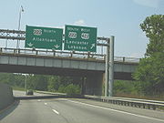
. In Hershey, Pennsylvania
, the eastern segment of US 422 begins at an interchange with US 322 and Pennsylvania Route 39
(PA 39). US 422 is named the Benjamin Franklin
Highway in Pennsylvania.
Originally, US 422 was routed along existing roads, but much of the route now runs along purpose-built alignments.
as the roadway heads south from the square. Less than a mile from the Public Square, US 422 and SR 14 intersect the Cleveland Innerbelt
, the confluence of Interstate 90
(I-90) and the northern termini of I-71 and I-77
. US 422 and SR 14 split at the interchange as SR 14 turns south to join State Route 43. State Route 8 begins at the eastern terminus of the US 422/SR 14 overlap, forming a concurrency with US 422 along Woodland Avenue.
US 422 runs easterly along Woodland Avenue and Kinsman Road, through the Kinsman neighborhood. As it crosses Cleveland's city limits just west of Lee Road in Shaker Heights
, the street name changes to Chagrin Boulevard, named for the Chagrin River
and Chagrin Falls (the eastern terminus of the boulevard) in Cleveland's eastern suburbs. Today, US 422 in Shaker Heights and Beachwood
, where it now merges with I-271, is almost a linear edge city
, with millions of square feet in office space centered on this corridor. It is one of the busiest streets in Cuyahoga County
and Greater Cleveland
. It serves as the primary commercial district for the wealthiest pocket of communities in Northeast Ohio.
At Northfield Road, SR 8 turns to the south, leaving US 422 to continue east along Chagrin Boulevard. Two miles east of SR 8 in Beachwood, US 422 intersects State Route 87 and State Route 175
, running concurrent with the former for two blocks to I-271
exit 29. Here, US 422 departs SR 87 and Chagrin Boulevard at the southbound ramp to I-271 and joins the expressway southward for 2.5 miles (4 km). At Exit 27, US 422 splits from I-271 and proceeds through the eastern suburbs of Cleveland as a limited-access highway, exiting Cuyahoga County
and entering Geauga County
.
In Auburn Township
, US 422 returns to grade-level upon crossing the LaDue Reservoir
. The route continues to the southeast, cutting through northeast Portage County
and then entering Trumbull County
, where US 422 runs through the center of Warren
and Girard
. The section from downtown Warren to State Route 46 is known as "The Strip" and is lined with shopping centers, fast-food restaurants and other retail establishments. In the 1960s and 1970s, nightclubs along The Strip attracted top-name entertainers. Eastwood Mall
is one of two large shopping malls located near US 422, along with the King of Prussia Mall
in King of Prussia, Pennsylvania.
Farther southeast, US 422 enters Youngstown
, Mahoning County before entering Pennsylvania.
. The route proceeds to the east, passing through Lawrence
, Butler
, Armstrong
, Indiana
, and Cambria
counties in the western portion of the state. Major cities along the route include New Castle, Butler
, Kittanning
, and Indiana
.
West of Ebensburg, US 422 terminates at an interchange with US 219; a sign directs truck traffic to US 22 to use US 219. The former right-of-way of US 422 continues through Ebensburg to US 22 on the eastern edge of town.
 The eastern section of US 422 begins at an interchange with US 322 and PA 39 in Hershey
near the Hershey Medical Center and just outside Hummelstown
. US 422 proceeds east as a two-or-three-lane highway, traveling through Palmyra
, Annville
and Cleona
. In Lebanon
, US 422 departs Cumberland Street to southbound 12th Street then turns left onto Walnut Street as its eastbound alignment. Cumberland Street is its one-way westbound alignment. It returns to a two-to-three-lane road east from Lebanon to Myerstown
, and Wernersville
prior to entering the Berks County
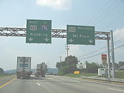
city of Reading
.
 In West Lawn
, outside of Reading, US 422 interchanges with the limited-access US 222. US 422 Business
, the former routing of US 422 through the city, continues along the right-of-way
of US 422 while US 422 merges with the expressway. The US 222/US 422 concurrency travels northward through the immediate western suburbs of Reading before separating at an interchange with PA 12
on the bank of the Schuylkill River
. US 222 turns to the west to bypass Reading to the north while US 422 passes to the immediate south of downtown, paralleling the Schuylkill as it heads east.
Southeast of Reading, US 422 meets the northern terminus of I-176
in Cumru Township
. Two miles to the east in Lorane
, US 422 intersects the eastern terminus of US 422 Business by way of an interchange. US 422 returns to grade-level a short distance to the east.
 East of an intersection with PA 662
in Douglassville
and 1.5 miles (2.4 km) west of the Berks-Montgomery
county line, US 422 separates from the Benjamin Franklin Highway and becomes the limited-access Pottstown
Bypass (colloquially known as the "422 Bypass" or simply "The Bypass"). Following the Stowe exit, US 422 briefly crosses the Schuylkill River
entering the Chester County
census-designated place
of South Pottstown
and interchanges with PA 100
.
 Midway between Pottstown
and Limerick, US 422 passes the Pottstown Limerick Airport
, one of numerous local airport
s in eastern Pennsylvania. On the west side of the road, US 422 passes a commercial outlet center, the Philadelphia Premium Outlets, built in 2007.
US 422 passes Royersford
, Collegeville
and Oaks
, and provides access to the sprawling Oaks Corporate Center office park on Egypt Road, then continues to Trooper
, and finally arrives at its eastern terminus at an interchange with US 202 in King of Prussia
, an area where heavy traffic caused by commuters traveling into Philadelphia during each weekday morning rush hour
often causes severe traffic jams.
The terminus of US 422 in King of Prussia is accessible from a number of major roadways in the area, including the Pennsylvania Turnpike
, the Schuylkill Expressway
, and US 202
. The terminus is adjacent to the Valley Forge
Turnpike interchange, one of the most notable on the Turnpike as the exit marks the location where I-76, which in Pennsylvania runs concurrent with the Turnpike mainline west of Valley Forge, separates from the Turnpike and turns southeast to Philadelphia as the Schuylkill Expressway, while the Pennsylvania Turnpike continues east to New Jersey as I-276 (and, in the near future, I-95
).
, Geauga County was twinned during World War II
. The four-lane divided highway was extended to Warren by 1950. In 1971, an expressway bypass around downtown Youngstown opened.
The divided highway portion of US 422 connecting downtown Solon
to I-271
and I-480
was originally signed as US 422 Alternate. In 1991, the freeway was extended eastward through Bainbridge Township
across the LaDue Reservoir
to State Route 44 in Auburn Center
, and US 422 was rerouted along I-271 and the former US 422 alternate. The new freeway made US 422 a popular route for truckers and commuters and made the remaining two-lane portion in Geauga County particularly dangerous. The state has added traffic light
s, rumble strip
s and extra width to the road to try to alleviate some of the danger.
Prior to the realignment, US 422 originally ran along Chagrin Boulevard (formerly Kinsman Road) through Woodmere
, Pepper Pike, Moreland Hills
, Chagrin Falls
and Bainbridge Township.
bypass of Butler
was built in the early 1960s. The section that runs through Moraine State Park
near Butler was upgraded to expressway standards in 1969. In the 1970s, bypasses were built around the cities of New Castle, Kittanning and Indiana. Sections of the Indiana bypass remained incomplete until 1995 and the Kittanning bypasses were completed in 2000. Part of the bypass in New Castle is now part of the Interstate Highway System
, as a recent extension of I-376
runs concurrent with US 422 for three miles (5 km).
 In the 1960s, US 422 in the Reading area was rerouted from surface streets through downtown Reading onto bypasses built south of the city. The former routing of US 422 through the city became US 422 Business
.
In the first decade of the 2000s, this segment of US 422 saw traffic volume increase by 50%. Volume reached 45,000 vehicles per day at Pottstown, and 110,000 vehicles per day at the bridge crossing the Schuylkill.
At the federal level, the Schuylkill Valley Metro
was proposed to connect Philadelphia to Reading. This rail service would parallel US 422 from King of Prussia into Berks County. It failed when the bloated price tag of $1.3 billion did not receive federal funding in 2006.
Construction of a third westbound lane between PA 23
and PA 363
began in February 2008 and was completed roughly a year later. The project restructured the Route 23 interchange and squeezed three westbound lanes onto the existing Schuylkill River
crossing, using 11 feet (3.4 m) lanes and a narrower median guard.
Local planning commissions then created a "US 422 Corridor Master Plan". This plan addressed the future trends of traffic on US 422 through a set of sustainability programs, a proposed extension to SEPTA's Manayunk/Norristown Line
regional rail service to Wyomissing (a restoration of rail service between Norristown/Reading/Pottsville that SEPTA abruptly terminated in July 1981), and additional road construction. The plan's rail and construction projects would be funded by tolling the highway. Tolls would be charged on a per-mile basis; driving the entire segment between Pottstown and King of Prussia would cost $2. All tolls would be electronically collected via the E-ZPass
electronic toll-collection system. The plan was debated in local municipalities during 2010, with many adopting the sustainability portions of the plan while objecting to the charging of tolls. A decision on whether the tolls will be implemented is expected in the early part of 2011.
shopping complex was also affected.
|rowspan=2|West Lawn
|colspan=3 align="center"|West end of freeway
|-
|-
|colspan=3 align="center"|East end of freeway
|-
|-
|colspan=3 align="center"|West end of freeway
|-
|-
|rowspan=2|
|
|rowspan=2|Eastern terminus of eastern segment
|-
|
|-
. Winding its way through the city center, the route changes directions several times as it functions as portions of State Street, Jefferson Avenue, Washington Street, and, in a more tree-lined residential area, Butler Street. Closer to its eastern edge, it passes commercial development, and it joins with US 422 as its freeway segment ends.
, before arching around commercial development in West Kittanning
and crossing the Kittanning Citizens Bridge
. After serving as the major Water Street, the route winds out of Kittanning toward the edge of the bypass.
. Despite functioning as a business route for a freeway bypass, the road does not completely follow its parent's original path, nor does it enter the city center. It instead encompasses a much more rural path, starting in the west on Pike Avenue near the outskirts of Indiana, then corresponding with Warren Road and Indian Springs Road, before reaching some development on Wayne Avenue, as it meets back up with the freeway.
, Pennsylvania
area. The route is one of four auxiliary routes of US 422 in Pennsylvania. Its western terminus is at an interchange with US 222 and US 422 in Wyomissing
. Its eastern terminus is at an interchange with US 422 in Reiffton
.
Spur route
A spur route is a short road forming a branch from a longer, more important route . A bypass or beltway is never considered a true spur route as it typically reconnects with the major road...
of US 22
U.S. Route 22
U.S. Route 22 is a west–east route and is one of the original United States highways of 1926, running from Cincinnati, Ohio, at US 27, US 42, US 127, and US 52 to Newark, New Jersey, at U.S. Route 1/9 near the Newark Liberty International Airport.US 22 also carries the names of the William...
split into two segments in the U.S. state
U.S. state
A U.S. state is any one of the 50 federated states of the United States of America that share sovereignty with the federal government. Because of this shared sovereignty, an American is a citizen both of the federal entity and of his or her state of domicile. Four states use the official title of...
s of Ohio
Ohio
Ohio is a Midwestern state in the United States. The 34th largest state by area in the U.S.,it is the 7th‑most populous with over 11.5 million residents, containing several major American cities and seven metropolitan areas with populations of 500,000 or more.The state's capital is Columbus...
and Pennsylvania
Pennsylvania
The Commonwealth of Pennsylvania is a U.S. state that is located in the Northeastern and Mid-Atlantic regions of the United States. The state borders Delaware and Maryland to the south, West Virginia to the southwest, Ohio to the west, New York and Ontario, Canada, to the north, and New Jersey to...
. The western spur begins in downtown Cleveland
Cleveland, Ohio
Cleveland is a city in the U.S. state of Ohio and is the county seat of Cuyahoga County, the most populous county in the state. The city is located in northeastern Ohio on the southern shore of Lake Erie, approximately west of the Pennsylvania border...
, Ohio, and ends at Ebensburg
Ebensburg, Pennsylvania
Ebensburg is a borough located in, and is the seat of, Cambria County, Pennsylvania, west of Altoona and surrounded by Cambria Township. It is situated in the Alleghenies about 2025 feet above sea level. Ebensburg is located in a rich bituminous coal region. In the past, saw mills, tanneries,...
, Pennsylvania. The eastern spur, located entirely within Pennsylvania, begins in Hershey
Hershey, Pennsylvania
Hershey is a census-designated place in Derry Township, Dauphin County in the Commonwealth of Pennsylvania. The community is located 14 miles east of Harrisburg and is part of the Harrisburg–Carlisle Metropolitan Statistical Area. Hershey has no legal status as an incorporated municipality...
and ends at King of Prussia
King of Prussia, Pennsylvania
King of Prussia is a census-designated place in Upper Merion Township, Montgomery County, Pennsylvania, United States. As of the 2010 census, its population was 19,936. The community took its name in the 18th century from a local tavern named the King of Prussia Inn, which was named after...
, near Philadelphia.
The segmented nature of US 422 violates AASHTO numbering, as two separate roadways traditionally do not carry the same route number. However, the two sections of US 422 are connected by US 22 and US 322
U.S. Route 322 in Pennsylvania
U.S. Route 322 is a U.S. highway running from Cleveland, Ohio east to Atlantic City, New Jersey. In the U.S. state of Pennsylvania, the route runs from the Ohio border in West Shenango Township southeast to the Commodore Barry Bridge over the Delaware River in Chester, at which point the route...
, allowing the two halves of US 422 to carry the same designation.
In downtown Cleveland
Downtown Cleveland
Downtown Cleveland is the central business district of the City of Cleveland and Northeast Ohio. Reinvestment in the area in the mid-1990s spurred a rebirth that continues to this day, with over $2 billion in residential and commercial developments slated for the area over the next few years...
, the western terminus of the western segment of US 422 is at US 6, US 20
U.S. Route 20
U.S. Route 20 is an east–west United States highway. As the "0" in its route number implies, US 20 is a coast-to-coast route. Spanning , it is the longest road in the United States, and the route sparsely parallels Interstate 90...
, US 42
U.S. Route 42
U.S. Route 42 is an east–west United States highway that runs northeast-southwest for 355 miles from Cleveland, Ohio to Louisville, Kentucky. The route has several names including Pearl Road from Cleveland to Medina in Northeast Ohio, the Cincinnati and Lebanon Pike in southwestern Ohio and...
, and State Route 3 in Cleveland's Public Square
Public Square
Public Square is the central plaza in downtown Cleveland, Ohio, United States. It takes up four city blocks; Superior Avenue and Ontario Street cross through it. Cleveland's three tallest buildings, Key Tower, 200 Public Square and the Terminal Tower, face the square...
. In Hershey, Pennsylvania
Hershey, Pennsylvania
Hershey is a census-designated place in Derry Township, Dauphin County in the Commonwealth of Pennsylvania. The community is located 14 miles east of Harrisburg and is part of the Harrisburg–Carlisle Metropolitan Statistical Area. Hershey has no legal status as an incorporated municipality...
, the eastern segment of US 422 begins at an interchange with US 322 and Pennsylvania Route 39
Pennsylvania Route 39
Pennsylvania Route 39 is a long east–west state highway in Dauphin County, Pennsylvania, United States. It starts at North Front Street north of Harrisburg and ends at U.S. Route 322 and U.S. Route 422 near Hummelstown...
(PA 39). US 422 is named the Benjamin Franklin
Benjamin Franklin
Dr. Benjamin Franklin was one of the Founding Fathers of the United States. A noted polymath, Franklin was a leading author, printer, political theorist, politician, postmaster, scientist, musician, inventor, satirist, civic activist, statesman, and diplomat...
Highway in Pennsylvania.
Originally, US 422 was routed along existing roads, but much of the route now runs along purpose-built alignments.
Ohio
The western section of US 422 begins at the center of Cleveland's Public Square in the downtown district. US 422 and State Route 14, which shares its western terminus with that of US 422, form a concurrencyConcurrency (road)
A concurrency, overlap, or coincidence in a road network is an instance of one physical road bearing two or more different highway, motorway, or other route numbers...
as the roadway heads south from the square. Less than a mile from the Public Square, US 422 and SR 14 intersect the Cleveland Innerbelt
Innerbelt Freeway
An Innerbelt Freeway is a set of freeway facilities arranged in a loop that serves the interior of a major city, primarily as a traffic reliever for downtown commuters...
, the confluence of Interstate 90
Interstate 90 in Ohio
In the U.S. state of Ohio, Interstate 90 runs east–west across the northern tier. Much of it is along the Ohio Turnpike, but sections outside the turnpike pass through Cleveland and northeast into Pennsylvania.-Route description:...
(I-90) and the northern termini of I-71 and I-77
Interstate 77 in Ohio
Interstate 77 is an Interstate Highway in the eastern United States. It traverses diverse terrain, from the mountainous state of West Virginia to the rolling farmlands of North Carolina and Ohio. It largely supplants the old U.S. Route 21 between Cleveland, Ohio, and Columbia, South Carolina, as...
. US 422 and SR 14 split at the interchange as SR 14 turns south to join State Route 43. State Route 8 begins at the eastern terminus of the US 422/SR 14 overlap, forming a concurrency with US 422 along Woodland Avenue.
US 422 runs easterly along Woodland Avenue and Kinsman Road, through the Kinsman neighborhood. As it crosses Cleveland's city limits just west of Lee Road in Shaker Heights
Shaker Heights, Ohio
Shaker Heights is a city in Cuyahoga County, Ohio, United States. As of the 2010 Census, the city population was 28,448. It is an inner-ring streetcar suburb of Cleveland that abuts the city on its eastern side.-Topography:Shaker Heights is located at...
, the street name changes to Chagrin Boulevard, named for the Chagrin River
Chagrin River
The Chagrin River is located in Northeast Ohio. The river has two branches, the Aurora Branch and East Branch. Its name is believed to stem from what the local Erie Indians used to call it, the "Sha-ga-rin", or "Clear Water". Given the clear flowing nature of especially the East Branch of the...
and Chagrin Falls (the eastern terminus of the boulevard) in Cleveland's eastern suburbs. Today, US 422 in Shaker Heights and Beachwood
Beachwood, Ohio
-External links:* *...
, where it now merges with I-271, is almost a linear edge city
Edge city
"Edge city" is an American term for a concentration of business, shopping, and entertainment outside a traditional urban area in what had recently been a residential suburb or semi-rural community...
, with millions of square feet in office space centered on this corridor. It is one of the busiest streets in Cuyahoga County
Cuyahoga County, Ohio
Cuyahoga County is a county located in the state of Ohio, United States. It is the most populous county in Ohio; as of the 2010 census, the population was 1,280,122. Its county seat is Cleveland. Cuyahoga County is part of Greater Cleveland, a metropolitan area, and Northeast Ohio, a...
and Greater Cleveland
Greater Cleveland
Greater Cleveland is a nickname for the metropolitan area surrounding Cleveland, Ohio and is part of what used to be the Connecticut Western Reserve.Northeast Ohio refers to a similar but substantially larger area as described below...
. It serves as the primary commercial district for the wealthiest pocket of communities in Northeast Ohio.
At Northfield Road, SR 8 turns to the south, leaving US 422 to continue east along Chagrin Boulevard. Two miles east of SR 8 in Beachwood, US 422 intersects State Route 87 and State Route 175
Ohio State Route 175
State Route 175 is a long north–south state highway in the northeastern part of the U.S. state of Ohio. The southern terminus of SR 175 is at a signalized intersection with SR 43 in Solon...
, running concurrent with the former for two blocks to I-271
Interstate 271
Interstate 271 is an auxiliary interstate highway in the suburbs of Cleveland and Akron in the U.S. state of Ohio. The highway is officially designated the "Cleveland Outerbelt East", but rarely referred to by that name.-Route description:...
exit 29. Here, US 422 departs SR 87 and Chagrin Boulevard at the southbound ramp to I-271 and joins the expressway southward for 2.5 miles (4 km). At Exit 27, US 422 splits from I-271 and proceeds through the eastern suburbs of Cleveland as a limited-access highway, exiting Cuyahoga County
Cuyahoga County, Ohio
Cuyahoga County is a county located in the state of Ohio, United States. It is the most populous county in Ohio; as of the 2010 census, the population was 1,280,122. Its county seat is Cleveland. Cuyahoga County is part of Greater Cleveland, a metropolitan area, and Northeast Ohio, a...
and entering Geauga County
Geauga County, Ohio
Geauga County is a county located in the state of Ohio, United States. As of the 2010 census, the population was 93,389. It is named for a Native American word meaning "raccoon". The county seat is Chardon...
.
In Auburn Township
Auburn Township, Geauga County, Ohio
Auburn Township is one of the sixteen townships of Geauga County, Ohio, United States. The 2000 census found 5,158 people in the township.-Geography:Located in the southern part of the county, it borders the following townships and city:...
, US 422 returns to grade-level upon crossing the LaDue Reservoir
LaDue Reservoir
LaDue Reservoir is a reservoir located near Ohio State Route 44 and U.S. Route 422 in Auburn and Troy Townships in Geauga County, Ohio. The reservoir was originally called the “Akron City Reservoir” before it was renamed for Wendell R. LaDue...
. The route continues to the southeast, cutting through northeast Portage County
Portage County, Ohio
Portage County is a county located in the U.S. state of Ohio. The population was 152,061 at the 2000 Census and 161,419 at the 2010 Census. Its county seat is Ravenna. Portage County is named for the portage between the Cuyahoga and Tuscarawas Rivers...
and then entering Trumbull County
Trumbull County, Ohio
As of the census of 2000, there were 225,116 people, 89,020 households, and 61,690 families residing in the county. The population density was 365 people per square mile . There were 95,117 housing units at an average density of 154 per square mile...
, where US 422 runs through the center of Warren
Warren, Ohio
As of the census of 2000, there were 46,832 people, 19,288 households and 12,035 families residing in the city. The population density was 2,912.4 people per square mile . There were 21,279 housing units at an average density of 1,322.9 per square mile...
and Girard
Girard, Ohio
Girard is a city in Trumbull County, Ohio, United States. The population was 10,902 at the 2000 census. It is part of the Youngstown–Warren–Boardman, OH-PA Metropolitan Statistical Area.-Geography:Girard is located at ....
. The section from downtown Warren to State Route 46 is known as "The Strip" and is lined with shopping centers, fast-food restaurants and other retail establishments. In the 1960s and 1970s, nightclubs along The Strip attracted top-name entertainers. Eastwood Mall
Eastwood Mall
Eastwood Village, formerly Eastwood Mall, is a shopping mall located in Birmingham, Alabama, United States. It is located between Montclair Road and Crestwood Boulevard Eastwood Village, formerly Eastwood Mall, is a shopping mall located in Birmingham, Alabama, United States. It is located between...
is one of two large shopping malls located near US 422, along with the King of Prussia Mall
King of Prussia Mall
The King of Prussia Mall is the largest shopping mall on the East Coast of the United States, and largest shopping mall in the United States of America in terms of leasable retail space....
in King of Prussia, Pennsylvania.
Farther southeast, US 422 enters Youngstown
Youngstown, Ohio
Youngstown is a city in the U.S. state of Ohio and the county seat of Mahoning County; it also extends into Trumbull County. The municipality is situated on the Mahoning River, approximately southeast of Cleveland and northwest of Pittsburgh, Pennsylvania...
, Mahoning County before entering Pennsylvania.
Pennsylvania
US 422 enters Pennsylvania eight miles (13 km) northwest of New CastleNew Castle, Pennsylvania
New Castle is a city in Lawrence County, Pennsylvania, United States, northwest of Pittsburgh and near the Pennsylvania-Ohio border just east of Youngstown, Ohio; in 1910, the total population was 36,280; in 1920, 44,938; and in 1940, 47,638. The population has fallen to 26,309 according to the...
. The route proceeds to the east, passing through Lawrence
Lawrence County, Pennsylvania
Lawrence County is a county located in the U.S. state of Pennsylvania. In 2010, its population was 91,108. The county was added to the Pittsburgh Metropolitan Statistical Area in 2003. The county seat is New Castle....
, Butler
Butler County, Pennsylvania
-Demographics:As of the census of 2000, there were 174,083 people, 65,862 households, and 46,827 families residing in the county. The population density was 221 people per square mile . There were 69,868 housing units at an average density of 89 per square mile...
, Armstrong
Armstrong County, Pennsylvania
Armstrong County is a county located in the U.S. state of Pennsylvania. As of the 2010 census, the population was 68,941. It is located northeast of Pittsburgh and Allegheny County. Armstrong County was added to the Pittsburgh Metropolitan Statistical Area in 2003.The county seat is Kittanning...
, Indiana
Indiana County, Pennsylvania
-Government and politics:As of November 2008, there are 58,077 registered voters in Indiana County .* Democratic: 26,653 * Republican: 24,159 * Other Parties: 7,265 -County commissioners:*Rodney Ruddock, Chairman, Republican...
, and Cambria
Cambria County, Pennsylvania
Cambria County is a county located in the U.S. state of Pennsylvania. It comprises the Johnstown, Pennsylvania, Metropolitan Statistical Area. As of 2010, the population was 143,679....
counties in the western portion of the state. Major cities along the route include New Castle, Butler
Butler, Pennsylvania
The city of Butler is the county seat of Butler County in the U.S. state of Pennsylvania, situated north of Pittsburgh. The population was 15,121 at the 2000 census.- History :...
, Kittanning
Kittanning, Pennsylvania
Kittanning is a borough and the county seat of Armstrong County, Pennsylvania in the United States. It is situated northeast of Pittsburgh, along the east bank of the Allegheny River. The name means "at the great stream" in the Delaware language...
, and Indiana
Indiana, Pennsylvania
Indiana is a borough in and the county seat of Indiana County, Pennsylvania, United States. The population was 14,895 at the 2000 census.The borough and the region as a whole promotes itself as the "Christmas Tree Capital of the World" because the national Christmas Tree Grower's Association was...
.
West of Ebensburg, US 422 terminates at an interchange with US 219; a sign directs truck traffic to US 22 to use US 219. The former right-of-way of US 422 continues through Ebensburg to US 22 on the eastern edge of town.
Pennsylvania
Hershey, Pennsylvania
Hershey is a census-designated place in Derry Township, Dauphin County in the Commonwealth of Pennsylvania. The community is located 14 miles east of Harrisburg and is part of the Harrisburg–Carlisle Metropolitan Statistical Area. Hershey has no legal status as an incorporated municipality...
near the Hershey Medical Center and just outside Hummelstown
Hummelstown, Pennsylvania
Hummelstown is a borough in Dauphin County, Pennsylvania, United States. The population was 4,360 as of the 2000 census. It is part of the Harrisburg–Carlisle Metropolitan Statistical Area....
. US 422 proceeds east as a two-or-three-lane highway, traveling through Palmyra
Palmyra, Pennsylvania
Palmyra is a borough in Lebanon County, Pennsylvania, United States. It is part of the Lebanon, PA Metropolitan Statistical Area. The population was 7,096 at the 2000 census.-Geography:Palmyra is located at ....
, Annville
Annville, Pennsylvania
Annville Township is a township and census-designated place in Lebanon County, Pennsylvania, United States. The population was 4,518 at the 2000 census.-Geography:Annville Township is located at ....
and Cleona
Cleona, Pennsylvania
Cleona is a borough in Lebanon County, Pennsylvania, United States. It is part of the Lebanon, Pennsylvania Metropolitan Statistical Area.The population was 2,148 at the 2000 census.-Geography:Cleona is located at ....
. In Lebanon
Lebanon, Pennsylvania
Lebanon, formerly known as Steitztown, is a city in and the county seat of Lebanon County, Pennsylvania, United States. The population was 25,477 at the 2010 census, a 4.2% increase from the 2000 count of 24,461...
, US 422 departs Cumberland Street to southbound 12th Street then turns left onto Walnut Street as its eastbound alignment. Cumberland Street is its one-way westbound alignment. It returns to a two-to-three-lane road east from Lebanon to Myerstown
Myerstown, Pennsylvania
Myerstown is a borough located in Lebanon County, Pennsylvania. It is part of the Lebanon, PA Metropolitan Statistical Area. As of the 2000 census, the borough had a total population of 3,171...
, and Wernersville
Wernersville, Pennsylvania
Wernersville is a borough in Berks County, Pennsylvania, United States. The population was 2,494 at the 2010 census.-Geography:Wernersville is located at .-History:...
prior to entering the Berks County
Berks County, Pennsylvania
-Demographics:As of the census of 2000, there were 373,638 people, 141,570 households, and 98,532 families residing in the county. The population density was 435 people per square mile . There were 150,222 housing units at an average density of 175 per square mile...
city of Reading
Reading, Pennsylvania
Reading is a city in southeastern Pennsylvania, USA, and seat of Berks County. Reading is the principal city of the Greater Reading Area and had a population of 88,082 as of the 2010 census, making it the fifth most populated city in the state after Philadelphia, Pittsburgh, Allentown and Erie,...
.
West Lawn, Pennsylvania
West Lawn is a former borough in Berks County, Pennsylvania, United States. The population was 1,597 at the 2000 census. This borough was dissolved and became part of Spring Township on January 1, 2006...
, outside of Reading, US 422 interchanges with the limited-access US 222. US 422 Business
U.S. Route 422 Business (Reading, Pennsylvania)
U.S. Route 422 Business is a long auxiliary route of U.S. Route 422 located in the Reading, Pennsylvania area. The route is one of four auxiliary routes of US 422 in Pennsylvania. Its western terminus is at an interchange with U.S. Route 222 and US 422 in Wyomissing...
, the former routing of US 422 through the city, continues along the right-of-way
Easement
An easement is a certain right to use the real property of another without possessing it.Easements are helpful for providing pathways across two or more pieces of property or allowing an individual to fish in a privately owned pond...
of US 422 while US 422 merges with the expressway. The US 222/US 422 concurrency travels northward through the immediate western suburbs of Reading before separating at an interchange with PA 12
Pennsylvania Route 12
Pennsylvania Route 12 is a long part-freeway located in eastern Pennsylvania. The western terminus of the route is at U.S. Route 422 and U.S. Route 222 near Reading. Its eastern terminus is Pennsylvania Route 662 in Ruscombmanor Township. In Reading, the freeway is named the Warren Street Bypass...
on the bank of the Schuylkill River
Schuylkill River
The Schuylkill River is a river in Pennsylvania. It is a designated Pennsylvania Scenic River.The river is about long. Its watershed of about lies entirely within the state of Pennsylvania. The source of its eastern branch is in the Appalachian Mountains at Tuscarora Springs, near Tamaqua in...
. US 222 turns to the west to bypass Reading to the north while US 422 passes to the immediate south of downtown, paralleling the Schuylkill as it heads east.
Southeast of Reading, US 422 meets the northern terminus of I-176
Interstate 176
Interstate 176 is a spur route of eastern Interstate 76 in Pennsylvania. I-176, known locally as the "Morgantown Expressway", travels from Morgantown, Pennsylvania to Reading, Pennsylvania; the entire length of the highway is just over...
in Cumru Township
Cumru Township, Pennsylvania
Cumru Township is a township in Berks County, Pennsylvania, United States. The population was 15,147 at the 2010 census. The name is Welsh in origin, likely from "Cymru" the Welsh name for Wales...
. Two miles to the east in Lorane
Lorane, Pennsylvania
Lorane is a census-designated place in Exeter Township, Berks County, Pennsylvania, United States. The population was 2,994 at the 2000 census...
, US 422 intersects the eastern terminus of US 422 Business by way of an interchange. US 422 returns to grade-level a short distance to the east.
Pennsylvania Route 662
Pennsylvania Route 662 is a long road located in eastern Pennsylvania. Its northern terminus is at Pennsylvania Route 61 in Shoemakerville and its southern terminus is at U.S. Route 422 in Douglassville. The entire route is in Berks County...
in Douglassville
Douglassville, Pennsylvania
Douglassville is a community in Amity, Union Townships, and Douglass Townships Berks County, Pennsylvania, United States. Douglassville is situated along U.S. Route 422. Developments include the Amity Gardens subdivision, the West Ridge subdivision, the Briarwood subdivision, and the subdivision...
and 1.5 miles (2.4 km) west of the Berks-Montgomery
Montgomery County, Pennsylvania
Montgomery County is a county located in the U.S. state of Pennsylvania, in the United States. As of 2010, the population was 799,874, making it the third most populous county in Pennsylvania . The county seat is Norristown.The county was created on September 10, 1784, out of land originally part...
county line, US 422 separates from the Benjamin Franklin Highway and becomes the limited-access Pottstown
Pottstown, Pennsylvania
Pottstown is a borough in Montgomery County, Pennsylvania, United States northwest of Philadelphia and southeast of Reading, on the Schuylkill River. Pottstown was laid out in 1752–53 and named Pottsgrove in honor of its founder, John Potts. The old name was abandoned at the time of the...
Bypass (colloquially known as the "422 Bypass" or simply "The Bypass"). Following the Stowe exit, US 422 briefly crosses the Schuylkill River
Schuylkill River
The Schuylkill River is a river in Pennsylvania. It is a designated Pennsylvania Scenic River.The river is about long. Its watershed of about lies entirely within the state of Pennsylvania. The source of its eastern branch is in the Appalachian Mountains at Tuscarora Springs, near Tamaqua in...
entering the Chester County
Chester County, Pennsylvania
-State parks:*French Creek State Park*Marsh Creek State Park*White Clay Creek Preserve-Demographics:As of the 2010 census, the county was 85.5% White, 6.1% Black or African American, 0.2% Native American or Alaskan Native, 3.9% Asian, 0.0% Native Hawaiian, 1.8% were two or more races, and 2.4% were...
census-designated place
Census-designated place
A census-designated place is a concentration of population identified by the United States Census Bureau for statistical purposes. CDPs are delineated for each decennial census as the statistical counterparts of incorporated places such as cities, towns and villages...
of South Pottstown
South Pottstown, Pennsylvania
South Pottstown is a community in North Coventry Township, Chester County in the U.S. state of Pennsylvania. It is defined by the U.S. Census Bureau as a census-designated place for statistical purposes and does not have any legal status as a separately incorporated municipality. It is a part of...
and interchanges with PA 100
Pennsylvania Route 100
Pennsylvania Route 100 is a state highway in the U.S. state of Pennsylvania that runs from U.S. Route 202 in West Chester, Pennsylvania to Pennsylvania Route 309 in Pleasant Corners, Pennsylvania....
.
Pottstown, Pennsylvania
Pottstown is a borough in Montgomery County, Pennsylvania, United States northwest of Philadelphia and southeast of Reading, on the Schuylkill River. Pottstown was laid out in 1752–53 and named Pottsgrove in honor of its founder, John Potts. The old name was abandoned at the time of the...
and Limerick, US 422 passes the Pottstown Limerick Airport
Pottstown Limerick Airport
Heritage Field is a public use airport located three nautical miles east of the central business district of Pottstown, in Montgomery County, Pennsylvania, United States...
, one of numerous local airport
Airport
An airport is a location where aircraft such as fixed-wing aircraft, helicopters, and blimps take off and land. Aircraft may be stored or maintained at an airport...
s in eastern Pennsylvania. On the west side of the road, US 422 passes a commercial outlet center, the Philadelphia Premium Outlets, built in 2007.
US 422 passes Royersford
Royersford, Pennsylvania
Royersford is a borough in Montgomery County, Pennsylvania, northwest of Philadelphia, on the Schuylkill River. The town drew its name from the location of a ford across the Schuylkill River, which happened to be adjacent to land owned by the Royer family...
, Collegeville
Collegeville, Pennsylvania
Collegeville is a borough in Montgomery County, Pennsylvania, 30 miles northwest of Philadelphia on the Perkiomen Creek. Collegeville was incorporated in 1896. It is the seat of Ursinus College, opened in 1869...
and Oaks
Oaks, Pennsylvania
Oaks is a village located in Upper Providence Township, Montgomery County, Pennsylvania, 18 miles northwest of Philadelphia. Its boundaries are defined in large part by the village's position at the junction of Perkiomen Creek and the Schuylkill River.-History:The two waterways defined much of the...
, and provides access to the sprawling Oaks Corporate Center office park on Egypt Road, then continues to Trooper
Trooper, Pennsylvania
Trooper is a census-designated place in Montgomery County, Pennsylvania, United States. The population was 5,744 at the 2010 census.-Geography:Trooper is located at ....
, and finally arrives at its eastern terminus at an interchange with US 202 in King of Prussia
King of Prussia, Pennsylvania
King of Prussia is a census-designated place in Upper Merion Township, Montgomery County, Pennsylvania, United States. As of the 2010 census, its population was 19,936. The community took its name in the 18th century from a local tavern named the King of Prussia Inn, which was named after...
, an area where heavy traffic caused by commuters traveling into Philadelphia during each weekday morning rush hour
Rush hour
A rush hour or peak hour is a part of the day during which traffic congestion on roads and crowding on public transport is at its highest. Normally, this happens twice a day—once in the morning and once in the evening, the times during when the most people commute...
often causes severe traffic jams.
The terminus of US 422 in King of Prussia is accessible from a number of major roadways in the area, including the Pennsylvania Turnpike
Pennsylvania Turnpike
The Pennsylvania Turnpike is a toll highway system operated by the Pennsylvania Turnpike Commission in the Commonwealth of Pennsylvania, United States. The three sections of the turnpike system total . The main section extends from Ohio to New Jersey and is long...
, the Schuylkill Expressway
Schuylkill Expressway
The Schuylkill Expressway , locally known as the Schuylkill, is a freeway through southwestern Montgomery County and the city of Philadelphia, and the easternmost segment of Interstate 76 in the U.S. state of Pennsylvania...
, and US 202
U.S. Route 202 in Pennsylvania
U.S. Route 202 runs through the southeastern part of the U.S. state of Pennsylvania, passing through the northern and western suburbs of Philadelphia. It follows in a general southwest to northeast direction through the state, passing through West Chester, King of Prussia, Norristown,...
. The terminus is adjacent to the Valley Forge
Valley Forge, Pennsylvania
The Village of Valley Forge is an unincorporated settlement located on the west side of Valley Forge National Historical Park at the confluence of Valley Creek and the Schuylkill River in Pennsylvania, United States. The remaining village is in Schuylkill Township of Chester County, but once...
Turnpike interchange, one of the most notable on the Turnpike as the exit marks the location where I-76, which in Pennsylvania runs concurrent with the Turnpike mainline west of Valley Forge, separates from the Turnpike and turns southeast to Philadelphia as the Schuylkill Expressway, while the Pennsylvania Turnpike continues east to New Jersey as I-276 (and, in the near future, I-95
Interstate 95 in Pennsylvania
Interstate 95 is an Interstate highway running from Miami, Florida north to Houlton, Maine. In the U.S. state of Pennsylvania, the route is known by many as the Delaware Expressway, but is officially named The Vietnam Veterans Memorial Highway. and locally known as "95"...
).
Ohio
Most of the highway in Ohio still runs along its original alignment. The section in Parkman TownshipParkman Township, Geauga County, Ohio
Parkman Township is one of the sixteen townships of Geauga County, Ohio, United States. The 2000 census found 3,546 people in the township.-Geography:Located in the southeastern corner of the county, it borders the following townships:...
, Geauga County was twinned during World War II
World War II
World War II, or the Second World War , was a global conflict lasting from 1939 to 1945, involving most of the world's nations—including all of the great powers—eventually forming two opposing military alliances: the Allies and the Axis...
. The four-lane divided highway was extended to Warren by 1950. In 1971, an expressway bypass around downtown Youngstown opened.
The divided highway portion of US 422 connecting downtown Solon
Solon, Ohio
Solon is a city in Cuyahoga County, Ohio, and is an affluent suburb of Cleveland in the Northeast Ohio Region, the 14th largest Combined Statistical Area in the United States. As of the 2010 census, the city population was 23,348...
to I-271
Interstate 271
Interstate 271 is an auxiliary interstate highway in the suburbs of Cleveland and Akron in the U.S. state of Ohio. The highway is officially designated the "Cleveland Outerbelt East", but rarely referred to by that name.-Route description:...
and I-480
Interstate 480 (Ohio)
Interstate 480 is a loop highway that connects the Ohio Turnpike with suburban Cleveland, Ohio. The highway is officially designated the Outerbelt South Freeway, but it is rarely referred to by that name....
was originally signed as US 422 Alternate. In 1991, the freeway was extended eastward through Bainbridge Township
Bainbridge Township, Geauga County, Ohio
Bainbridge Township is one of the sixteen townships of Geauga County, Ohio, United States. The 2000 census found 10,916 people in the township.-Geography:Located in the southwestern corner of the county, it borders the following townships and cities:...
across the LaDue Reservoir
LaDue Reservoir
LaDue Reservoir is a reservoir located near Ohio State Route 44 and U.S. Route 422 in Auburn and Troy Townships in Geauga County, Ohio. The reservoir was originally called the “Akron City Reservoir” before it was renamed for Wendell R. LaDue...
to State Route 44 in Auburn Center
Auburn Township, Geauga County, Ohio
Auburn Township is one of the sixteen townships of Geauga County, Ohio, United States. The 2000 census found 5,158 people in the township.-Geography:Located in the southern part of the county, it borders the following townships and city:...
, and US 422 was rerouted along I-271 and the former US 422 alternate. The new freeway made US 422 a popular route for truckers and commuters and made the remaining two-lane portion in Geauga County particularly dangerous. The state has added traffic light
Traffic light
Traffic lights, which may also be known as stoplights, traffic lamps, traffic signals, signal lights, robots or semaphore, are signalling devices positioned at road intersections, pedestrian crossings and other locations to control competing flows of traffic...
s, rumble strip
Rumble strip
Rumble strips, also known as sleeper lines, are a road safety feature that alert inattentive drivers to potential danger by causing a tactile vibration and audible rumbling, transmitted through the wheels into the car body...
s and extra width to the road to try to alleviate some of the danger.
Prior to the realignment, US 422 originally ran along Chagrin Boulevard (formerly Kinsman Road) through Woodmere
Woodmere, Ohio
Woodmere is a village in Cuyahoga County, Ohio, United States. It is a suburb of Cleveland. The population was 884 at the 2010 census.-History:...
, Pepper Pike, Moreland Hills
Moreland Hills, Ohio
Moreland Hills is a village in Cuyahoga County, Ohio, United States. It is an affluent suburb of Cleveland. The population was 3,320 at the 2010 census.-History:...
, Chagrin Falls
Chagrin Falls, Ohio
Chagrin Falls is a village in Cuyahoga County, Ohio, United States. It is a suburb of Cleveland in the Northeast Ohio region, the 14th largest Combined Statistical Area nationwide. The village was established and has grown around a natural waterfall on the Chagrin River. As of the 2010 census,...
and Bainbridge Township.
Pennsylvania
The expresswayLimited-access road
A limited-access road known by various terms worldwide, including limited-access highway, dual-carriageway and expressway, is a highway or arterial road for high-speed traffic which has many or most characteristics of a controlled-access highway , including limited or no access to adjacent...
bypass of Butler
Butler, Pennsylvania
The city of Butler is the county seat of Butler County in the U.S. state of Pennsylvania, situated north of Pittsburgh. The population was 15,121 at the 2000 census.- History :...
was built in the early 1960s. The section that runs through Moraine State Park
Moraine State Park
Moraine State Park is a Pennsylvania state park on in Brady, Clay, Franklin, Muddy Creek, and Worth townships in Butler County, Pennsylvania, in the United States. The main feature of the park is its man-made lake, Lake Arthur, formed by impounding Muddy Creek, which is and is used for...
near Butler was upgraded to expressway standards in 1969. In the 1970s, bypasses were built around the cities of New Castle, Kittanning and Indiana. Sections of the Indiana bypass remained incomplete until 1995 and the Kittanning bypasses were completed in 2000. Part of the bypass in New Castle is now part of the Interstate Highway System
Interstate Highway System
The Dwight D. Eisenhower National System of Interstate and Defense Highways, , is a network of limited-access roads including freeways, highways, and expressways forming part of the National Highway System of the United States of America...
, as a recent extension of I-376
Interstate 376
Interstate 376 is a major auxiliary route of the Interstate Highway System in the U.S. state of Pennsylvania, located entirely within the Allegheny Plateau. It runs from I-80 near Sharon south and east to a junction with the Pennsylvania Turnpike in Monroeville, after having crossed the Turnpike...
runs concurrent with US 422 for three miles (5 km).
Reading
U.S. Route 422 Business (Reading, Pennsylvania)
U.S. Route 422 Business is a long auxiliary route of U.S. Route 422 located in the Reading, Pennsylvania area. The route is one of four auxiliary routes of US 422 in Pennsylvania. Its western terminus is at an interchange with U.S. Route 222 and US 422 in Wyomissing...
.
Pottstown to King of Prussia
Before it became highways, US 422 ran on surface roads through Pottstown, Plymouth Meeting, and the Germantown section of Philadelphia (via Germantown Pike and Germantown Avenue), terminating in different places in Philadelphia over time. In 1965, the highway route of US 422 was extended 8.4 miles (13.5 km) east with the "Pottstown Bypass", following the Schuylkill River and terminating at Township Line Road in Sanatoga. At the same time, a segment of highway was built from King of Prussia to Trooper, terminating at the Betzwood Bridge. It took roughly another twenty years for the remaining segments between Sanatoga and Trooper to be completed, finally connecting the highway route to King of Prussia. (Eastbound on US 422, the median strip widens just after the Sanatoga exit, as the road leaves the old Pottstown bypass.)In the first decade of the 2000s, this segment of US 422 saw traffic volume increase by 50%. Volume reached 45,000 vehicles per day at Pottstown, and 110,000 vehicles per day at the bridge crossing the Schuylkill.
At the federal level, the Schuylkill Valley Metro
Schuylkill Valley Metro
The Schuylkill Valley Metro was a proposal for a 62-mile railway system that would link Philadelphia, Pennsylvania with the city of Reading, Pennsylvania in central Berks County, USA, using the SEPTA Manayunk/Norristown Line and Cynwyd Line, as well as two current freight-only rights-of-way owned...
was proposed to connect Philadelphia to Reading. This rail service would parallel US 422 from King of Prussia into Berks County. It failed when the bloated price tag of $1.3 billion did not receive federal funding in 2006.
Construction of a third westbound lane between PA 23
Pennsylvania Route 23
Pennsylvania Route 23 is a state highway in southeastern Pennsylvania. The route begins at Pennsylvania Route 441 in Marietta and heads east to U.S. Route 1 in Philadelphia.-Marietta to Valley Forge:...
and PA 363
Pennsylvania Route 363
Pennsylvania Route 363 is a state highway located in Montgomery County, Pennsylvania that is a spur of PA 63. The route runs from an interchange with U.S. Route 422 near Valley Forge northeast to PA 63 in Lansdale. The route runs through suburban areas of central Montgomery County, passing some...
began in February 2008 and was completed roughly a year later. The project restructured the Route 23 interchange and squeezed three westbound lanes onto the existing Schuylkill River
Schuylkill River
The Schuylkill River is a river in Pennsylvania. It is a designated Pennsylvania Scenic River.The river is about long. Its watershed of about lies entirely within the state of Pennsylvania. The source of its eastern branch is in the Appalachian Mountains at Tuscarora Springs, near Tamaqua in...
crossing, using 11 feet (3.4 m) lanes and a narrower median guard.
Local planning commissions then created a "US 422 Corridor Master Plan". This plan addressed the future trends of traffic on US 422 through a set of sustainability programs, a proposed extension to SEPTA's Manayunk/Norristown Line
Manayunk/Norristown Line
The Manayunk/Norristown Line is a SEPTA Regional Rail line running from Center City Philadelphia to the Elm Street station in Norristown, Montgomery County.-Route:...
regional rail service to Wyomissing (a restoration of rail service between Norristown/Reading/Pottsville that SEPTA abruptly terminated in July 1981), and additional road construction. The plan's rail and construction projects would be funded by tolling the highway. Tolls would be charged on a per-mile basis; driving the entire segment between Pottstown and King of Prussia would cost $2. All tolls would be electronically collected via the E-ZPass
E-ZPass
E-ZPass is an electronic toll-collection system used on most tolled roads, bridges, and tunnels in the northeastern US, south to Virginia and West Virginia, and west to Illinois. Currently, there are 25 agencies spread across 14 states that make up the . All member agencies use the same technology,...
electronic toll-collection system. The plan was debated in local municipalities during 2010, with many adopting the sustainability portions of the plan while objecting to the charging of tolls. A decision on whether the tolls will be implemented is expected in the early part of 2011.
King of Prussia termination
In the early 2000s, the US 422, US 202, and I-76 interchange in King of Prussia underwent a massive five-year reconstruction project that involved the construction of new ramps and the widening of all intersecting roadways. Several small businesses in the King of Prussia area were demolished as part of this project: the nearby King of Prussia MallKing of Prussia Mall
The King of Prussia Mall is the largest shopping mall on the East Coast of the United States, and largest shopping mall in the United States of America in terms of leasable retail space....
shopping complex was also affected.
Western segment
- U.S. Route 322U.S. Route 322U.S. Route 322 is a long, east–west United States Highway, traversing Ohio, Pennsylvania, and New Jersey. The road is a spur of U.S. Route 22 and one of the original highways from 1926...
in Cleveland, OhioOhioOhio is a Midwestern state in the United States. The 34th largest state by area in the U.S.,it is the 7th‑most populous with over 11.5 million residents, containing several major American cities and seven metropolitan areas with populations of 500,000 or more.The state's capital is Columbus... - Interstate 90Interstate 90Interstate 90 is the longest Interstate Highway in the United States at . It is the northernmost coast-to-coast interstate, and parallels US 20 for the most part. Its western terminus is in Seattle, at Edgar Martinez Drive S. near Safeco Field and CenturyLink Field, and its eastern terminus is in...
in Cleveland, OhioOhioOhio is a Midwestern state in the United States. The 34th largest state by area in the U.S.,it is the 7th‑most populous with over 11.5 million residents, containing several major American cities and seven metropolitan areas with populations of 500,000 or more.The state's capital is Columbus... - Interstate 71Interstate 71Interstate 71 is an Interstate Highway in the Great Lakes/Midwestern and Southeastern region of the United States. Its southern terminus is at an interchange with Interstate 64 and Interstate 65 in Louisville, Kentucky. Its northern terminus is at an interchange with Interstate 90 in Cleveland,...
in Cleveland, OhioOhioOhio is a Midwestern state in the United States. The 34th largest state by area in the U.S.,it is the 7th‑most populous with over 11.5 million residents, containing several major American cities and seven metropolitan areas with populations of 500,000 or more.The state's capital is Columbus... - Interstate 77Interstate 77Interstate 77 is an Interstate Highway in the eastern United States. It traverses diverse terrain, from the mountainous state of West Virginia to the rolling farmlands of North Carolina and Ohio. It largely supplants the old U.S...
in Cleveland, OhioOhioOhio is a Midwestern state in the United States. The 34th largest state by area in the U.S.,it is the 7th‑most populous with over 11.5 million residents, containing several major American cities and seven metropolitan areas with populations of 500,000 or more.The state's capital is Columbus... - Interstate 271Interstate 271Interstate 271 is an auxiliary interstate highway in the suburbs of Cleveland and Akron in the U.S. state of Ohio. The highway is officially designated the "Cleveland Outerbelt East", but rarely referred to by that name.-Route description:...
in Beachwood, OhioBeachwood, Ohio-External links:* *... - Interstate 480NInterstate 480 (Ohio)Interstate 480 is a loop highway that connects the Ohio Turnpike with suburban Cleveland, Ohio. The highway is officially designated the Outerbelt South Freeway, but it is rarely referred to by that name....
in Bedford Heights, OhioBedford Heights, Ohio-External links:*... - State Route 91 in Solon, OhioSolon, OhioSolon is a city in Cuyahoga County, Ohio, and is an affluent suburb of Cleveland in the Northeast Ohio Region, the 14th largest Combined Statistical Area in the United States. As of the 2010 census, the city population was 23,348...
- State Route 306 in Bainbridge Township, Ohio
- State Route 44 in Auburn Township, OhioAuburn Township, Geauga County, OhioAuburn Township is one of the sixteen townships of Geauga County, Ohio, United States. The 2000 census found 5,158 people in the township.-Geography:Located in the southern part of the county, it borders the following townships and city:...
- State Route 5 in Warren, OhioWarren, OhioAs of the census of 2000, there were 46,832 people, 19,288 households and 12,035 families residing in the city. The population density was 2,912.4 people per square mile . There were 21,279 housing units at an average density of 1,322.9 per square mile...
- State Route 82 in Warren, OhioWarren, OhioAs of the census of 2000, there were 46,832 people, 19,288 households and 12,035 families residing in the city. The population density was 2,912.4 people per square mile . There were 21,279 housing units at an average density of 1,322.9 per square mile...
- Interstate 80Interstate 80Interstate 80 is the second-longest Interstate Highway in the United States, following Interstate 90. It is a transcontinental artery running from downtown San Francisco, California to Teaneck, New Jersey in the New York City Metropolitan Area...
in Girard, OhioGirard, OhioGirard is a city in Trumbull County, Ohio, United States. The population was 10,902 at the 2000 census. It is part of the Youngstown–Warren–Boardman, OH-PA Metropolitan Statistical Area.-Geography:Girard is located at .... - State Route 711 in Youngstown, OhioYoungstown, OhioYoungstown is a city in the U.S. state of Ohio and the county seat of Mahoning County; it also extends into Trumbull County. The municipality is situated on the Mahoning River, approximately southeast of Cleveland and northwest of Pittsburgh, Pennsylvania...
- Interstate 376Interstate 376Interstate 376 is a major auxiliary route of the Interstate Highway System in the U.S. state of Pennsylvania, located entirely within the Allegheny Plateau. It runs from I-80 near Sharon south and east to a junction with the Pennsylvania Turnpike in Monroeville, after having crossed the Turnpike...
in New Castle, PennsylvaniaNew Castle, PennsylvaniaNew Castle is a city in Lawrence County, Pennsylvania, United States, northwest of Pittsburgh and near the Pennsylvania-Ohio border just east of Youngstown, Ohio; in 1910, the total population was 36,280; in 1920, 44,938; and in 1940, 47,638. The population has fallen to 26,309 according to the... - Interstate 79Interstate 79Interstate 79 is an Interstate Highway in the eastern United States, designated from Interstate 77 in Charleston, West Virginia to Pennsylvania Route 5 and Pennsylvania Route 290 in Erie, Pennsylvania...
in Portersville, PennsylvaniaPortersville, PennsylvaniaPortersville is a borough in Butler County, Pennsylvania, United States. The population was 268 at the 2000 census.-Geography:Portersville is located at .... - Pennsylvania Route 28Pennsylvania Route 28Pennsylvania Route 28 is a major state highway which runs for 97 miles from Interstate 279 and Interstate 579 at the Interstate 279 Interchange in Pittsburgh to U.S. Route 219 in Brockway in the U.S. state of Pennsylvania. The expressway from Kittanning to Pittsburgh is called the Alexander H...
in West Kittanning, PennsylvaniaWest Kittanning, PennsylvaniaWest Kittanning is a borough in Armstrong County, Pennsylvania, United States. The population was 1,199 at the 2000 census.- Geography :West Kittanning is located at .... - U.S. Highway 119 in Indiana, PennsylvaniaIndiana, PennsylvaniaIndiana is a borough in and the county seat of Indiana County, Pennsylvania, United States. The population was 14,895 at the 2000 census.The borough and the region as a whole promotes itself as the "Christmas Tree Capital of the World" because the national Christmas Tree Grower's Association was...
- U.S. Highway 22 in Ebensburg, PennsylvaniaEbensburg, PennsylvaniaEbensburg is a borough located in, and is the seat of, Cambria County, Pennsylvania, west of Altoona and surrounded by Cambria Township. It is situated in the Alleghenies about 2025 feet above sea level. Ebensburg is located in a rich bituminous coal region. In the past, saw mills, tanneries,...
Eastern segment
|-|rowspan=2|West Lawn
West Lawn, Pennsylvania
West Lawn is a former borough in Berks County, Pennsylvania, United States. The population was 1,597 at the 2000 census. This borough was dissolved and became part of Spring Township on January 1, 2006...
|colspan=3 align="center"|West end of freeway
|-
|-
|colspan=3 align="center"|East end of freeway
|-
|-
|colspan=3 align="center"|West end of freeway
|-
|-
|rowspan=2|
|
|rowspan=2|Eastern terminus of eastern segment
|-
|
|-
New Castle business route
U.S. Route 422 Business is a 7 miles (11.3 km) route following the original alignment of its parent. At its western edge, the route leaves the freeway and travels as a four-laner along the Beaver River. Amongst a combination of residences and light industry, the route confusingly meets US 224U.S. Route 224
U.S. Route 224 is a spur of U.S. Route 24. It currently runs for 289 miles from New Castle, Pennsylvania at Pennsylvania Route 18 to Huntington, Indiana at U.S. Route 24. It passes through the states of Pennsylvania, Ohio and Indiana...
. Winding its way through the city center, the route changes directions several times as it functions as portions of State Street, Jefferson Avenue, Washington Street, and, in a more tree-lined residential area, Butler Street. Closer to its eastern edge, it passes commercial development, and it joins with US 422 as its freeway segment ends.
Kittanning business route
U.S. Route 422 Business is a 5 miles (8 km) route following the original alignment of its parent. It begins in the west with a cosignment with PA 286Pennsylvania Route 286
Pennsylvania Route 286 is an long, east–west state highway located in Allegheny, Westmoreland, Indiana, and Clearfield counties in Pennsylvania. The western terminus is at US 22 in Monroeville. The eastern terminus is at US 219 near Burnside....
, before arching around commercial development in West Kittanning
West Kittanning, Pennsylvania
West Kittanning is a borough in Armstrong County, Pennsylvania, United States. The population was 1,199 at the 2000 census.- Geography :West Kittanning is located at ....
and crossing the Kittanning Citizens Bridge
Kittanning Citizens Bridge
The Kittanning Citizens Bridge is a through truss bridge spanning the Allegheny River at Kittanning in the U.S. state of Pennsylvania. Constructed in 1932, the bridge carries vehicles and pedestrians between Kittanning and West Kittanning. The bridge was used as a backdrop, and climax scene in...
. After serving as the major Water Street, the route winds out of Kittanning toward the edge of the bypass.
Indiana business route
U.S. Route 422 Business is a 7 miles (11.3 km) loop around Indiana, PennsylvaniaIndiana, Pennsylvania
Indiana is a borough in and the county seat of Indiana County, Pennsylvania, United States. The population was 14,895 at the 2000 census.The borough and the region as a whole promotes itself as the "Christmas Tree Capital of the World" because the national Christmas Tree Grower's Association was...
. Despite functioning as a business route for a freeway bypass, the road does not completely follow its parent's original path, nor does it enter the city center. It instead encompasses a much more rural path, starting in the west on Pike Avenue near the outskirts of Indiana, then corresponding with Warren Road and Indian Springs Road, before reaching some development on Wayne Avenue, as it meets back up with the freeway.
Reading business route
U.S. Route 422 Business is a 7 miles (11.3 km) long auxiliary route of US 422 located in the ReadingReading, Pennsylvania
Reading is a city in southeastern Pennsylvania, USA, and seat of Berks County. Reading is the principal city of the Greater Reading Area and had a population of 88,082 as of the 2010 census, making it the fifth most populated city in the state after Philadelphia, Pittsburgh, Allentown and Erie,...
, Pennsylvania
Pennsylvania
The Commonwealth of Pennsylvania is a U.S. state that is located in the Northeastern and Mid-Atlantic regions of the United States. The state borders Delaware and Maryland to the south, West Virginia to the southwest, Ohio to the west, New York and Ontario, Canada, to the north, and New Jersey to...
area. The route is one of four auxiliary routes of US 422 in Pennsylvania. Its western terminus is at an interchange with US 222 and US 422 in Wyomissing
Wyomissing, Pennsylvania
Wyomissing is a borough in Berks County, Pennsylvania, United States, established on July 2, 1906. The population was 8,587 at the 2000 census, but after the January, 2002 merger with neighboring Wyomissing Hills, the combined 2000 Census estimate was 11,155 making it the most populous borough in...
. Its eastern terminus is at an interchange with US 422 in Reiffton
Reiffton, Pennsylvania
Reiffton is a census-designated place in Exeter Township, Berks County, Pennsylvania, United States. The population was 2,888 at the 2000 census.-Geography:Reiffton is located at ....
.
External links
- US-422 Endpoint Photos
- Route 422 - John Simpson's Unofficial Ohio State Highways Web Site
- US 422 - Jeff Kitsko's Pennsylvania Highways