

Pattani Province
Encyclopedia
Pattani is one of the southern provinces
(changwat) of Thailand
. Neighboring provinces are (from south-east clockwise) Narathiwat
, Yala
and Songkhla
.
, with the coast of the Gulf of Thailand
in the north. In the south mountainous landscape with the Sankalakhiri mountain range
, including the Budo - Su-ngai Padi National Park, is located at the border to Yala and Narathiwat, protecting hill forests with rare vegetation such as the Bangsoon palm (Johnnesteijsmannia altifon) and Takathong rattan
, as well as birds like the hornbill
. Namtok Sai Khao on the border with Songkhla and Yala is a forest park, remarkable for the Sai Khao waterfall.
derivation of Patani (Jawi: ڤتنا); its original name could mean 'this beach' in Patani Malay language. In standard Malay, it is "Pantai Ini".
Historically Pattani province was the centre of the semi-independent Malay
Sultanate of Patani Darul Makrif, but paying tribute to the Thai kingdoms of Sukhothai
and Ayutthaya
. After Ayutthaya fell to the Burmese in 1767, the Sultanate of Patani gained full independence, but under King Rama I again came under Siam's control.
In 1909, the possession by Siam was officially sanctioned by the Anglo-Siamese Treaty of 1909
negotiated with the British Empire
. Both Yala (Jala) and Narathiwat (Menara) were originally part of Patani, but were made provinces of their own during the territorial administrative reform and the creation of a united centralized Siam state.
, making up 88% of the population. They speak the Patani Malay language. The Pattani Malays are very similar in ethnicity and culture to the Malays of Kelantan
, Malaysia.
shows the cannon called Phraya Tani, which was cast in the Pattani province. It was brought to Bangkok in 1785, and is now on display in front of the Ministry of Defence in Bangkok.
The provincial flower is the Chinese hibiscus
(Hibiscus rosa-sinensis), and the provincial tree the Ironwood
(Hopea odorata
).
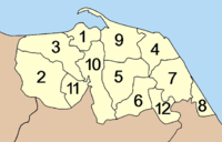 Pattani is subdivided into 12 districts (amphoe
), which are further subdivided into 115 communes (tambon
) and 629 villages (muban
).
The districts of Chana
(Malay: Chenok), Thepa
(Malay:Tiba) and Saba Yoi
(Malay:Sebayu) were detached from Pattani and transferred to Songkhla
in recent times by the Thai government.
Somdet Phra Srinagarindra Park (สวนสมเด็จพระศรีนครินทร์) The Park is decorated with many flowers and a very beautiful landscape.
Kallayaniwatthana Institute of Arts and Culture (สถาบันวัฒนธรรมศึกษากัลยาณิวัฒนา) The institute is divided into two sections:
1. Phra Thepyanmoli (พิพิธภัณฑ์พระเทพญาณโมลี) Museum displays the history, activities, and utensils of Phra Thepyanmoli.
2. Khatichon Witthaya Museum (พิพิธภัณฑ์คติชนวิทยา) displays the stories, case studies of the Muslim household in the Southern border provinces, local utensils, local arts and displays, ancient utensil materials in pre-historic and the beginning of community periods, history of the ancient town of Yarang, pottery, local beliefs and technology.
Pattani Central Mosque (มัสยิดกลางปัตตานี) This is the most beautiful and largest mosque in Thailand. It is the center for religious ceremonies to be performed by the Muslim citizens in the South. The architecture is western, with some similarity to the well known Taj Mahal of India. With the big dome in the center, there are four surrounding small ones with two minarets.
City Pillar Shrine (ศาลหลักเมือง) The shrine was constructed on 13 April 1951 when Phraya Rattana Phakdi was the Governor.
Krue Se Mosque (มัสยิดกรือเซะ)
This mosque has round pillars which is the middle-east arts style. An important feature is the domed roof, which has never been completed. It has been assured that this mosque was built during the reign of King Naresuan the Great (1578–1593).
Chao Mae Lim Ko Niao Graveyard (สุสานเจ้าแม่ลิ้มกอเหนี่ยว) As per the story of the legend, Lim Ko Niao, a Chinese girl which came to Pattani by ship to look for Lim To Khiam, her elder brother who had got married with the Pattani Governor’s daughter, converted to Islam and ordered the construction of the Krue Se mosque. However, she was not successful in taking his brother back home. Therefore, after putting a curse impeding the roof of the mosque to be completed, she hanged herself on a cashewnut tree near the mosque and her brother buried her at this place.
Chao Mae Lim Ko Niao Chinese Shrine or Leng Chu Kiang Shrine (ศาลเจ้าแม่ลิ้มกอเหนี่ยวหรือศาลเจ้าเล่งจูเกียง) On the day of the 3rd lunar month every year, there is the colorful procession carrying Chao Mae’s sculpture along several roads in town, walking on fire in front of the shrine, and swimming across the river near Dechanuchit Bridge.
Hat Talokapor ( Teluk Kapur ) Beach (หาดตะโละกาโปร์) With its long white sand, line of pines and coconut trees, this beach is one of the most popular ones in Pattani. There are many Korlae boats with their unique colorful characteristics of the southern fishermen.
Laem Ta Chi or Laem Pho (แหลมตาชี หรือ แหลมโพธิ์) This is another white-sand beach extended from Talokapor Beach. It has been the accumulation of sand spit into the Gulf of Thailand on the north.
Dato Mosque (มัสยิดบ้านดาโต๊ะ) This old mosque is surrounded by an islamic community and a graveyard, it has been renovated and still serves for religious ceremonies.
Yaring Natural Study Centre (ศูนย์ศึกษาธรรมชาติป่าชายเลนยะหริ่ง) There is a 1,250 meter long wooden bridge as the walkway for study purposes of the forest. Along the natural trail, there are several species of plants, rest area and a bird-watching tower with the height of 13 meters.
Hat Panare (หาดปะนาเระ) There are many households of fishermen, Korlae and boats along the beach. Seafood selling stalls by the beach are inexpensive and their selections are plentiful.
Hat Chalalai (หาดชลาลัย) The beach is highlighted by a large pond near the pine line.
Hat Ma Ruat (หาดมะรวด) This beach is characterized by the amazing site of the aggregated small rock mountains overlapping each other.
Hat Ratcharak (หาดราชรักษ์) This beach is extended from Chalalai, Maruad, and Khae Khae Beaches.
Hat Khae Khae (หาดแฆแฆ) “Khae Khae” is a local Malay word which means “loud noise”. With its large granite rocks along the coast, the beach looks quite different from the others and is naturally reputed as the most beautiful beaches in Panare.
Palas Market (ตลาดนัดปาลัส) This venue reflects the real rural lifestyle of the southern Thai Muslims.
Hat Wasukri (หาดวาสุกรี) The beach is about 52 kilometers from Pattani and about 2 kilometers from Sai Buri. It is in Patatimo ( Pantai Timur ) Village, Tambon Taluban.
Ban Paseyawo (บ้านปะเสยะวอ) This is a well-known venue for Korlae Boat making. The highlighting characteristics of the Korlae is the narrowing head and tail, with unique color. Besides the real Korlae for fishery, there are also imitations made for souvenirs.
Khao Ruesi (เขาฤาษี) The highlight of this mount is the natural rocky formation. Also, there are two ponds containing water which has been believed to be very holy and was used in the Coronation of many Kings.
Yarang Ancient Town (เมืองโบราณยะรัง) The city was one of the oldest communities in the history of the southern part of Thailand. It is believed that it was the location of the ancient kingdom of “Lanka Suka”. The structure of the ancient town was the large oval shape in the area of 9 square kilometers.
Wat Mutcharinthawapiwihan (วัดมุจลินทวาปีวิหาร) At present, its temple is still beautiful. With the sculptures of the last 3 abbots, especially Phra Ratchaphuttharangsi, the 5th abbot.
Hat Ratchadapisek (หาดรัชดาภิเษก) Situated at Ban Sai Mo, Tambon Sai Mo, this beach is about 15 kilometers from Pattani City, or 2 kilometers away from Nong Chik District Office.
King Rama VII Pavilion (พลับพลาที่ประทับรัชกาลที่ 7) This Thai style pavilion was built for King Rama VII during his visit to watch the eclipse in 1929.
Wat Chang Hai Rat Buranaram (วัดช้างให้ราษฎร์บูรณาราม) This monastery is at Ban Pa Rai, Tambon Tung Pala.
Wat Chang Hai - Royal Folk Arts and Crafts Center (ศูนย์ศิลปชีพวัดช้างให้) The center displays and sells many southern handicrafts such as batik cloth, miniature Kolae boats, handicrafts, mats, and ceramics.
Namtok Sai Khao National Park (อุทยานแห่งชาติน้ำตกทรายขาว) This evergreen forest is full of various kinds of plants, and a variety of waterfalls. The most beautiful waterfall here is called Sai Khao Waterfall. At the end, is a waterfall which drops for 40 meters.
Namtok Phong Phong (น้ำตกโผงโผง) With seven staged levels, this waterfall has a big pond at the lowest level.
Namtok Aran Warin (น้ำตกอรัญวาริน) Situated at Mu 4, Tambon Tung Pala. The total distance from Pattani is about 30 kilometers.
Hat Sai Chai Bueng Ban Laweng (หาดทรายชายบึงบ้านละเวง) Chai Bueng Ban Laweng has different surroundings and nature. There is a large pond near the white beach. Moreover, there is a local handicraft center (Ban Laweng) displaying weaving products.
Hat Bang Sai (หาดบางสาย) Located at Mu 6, Tambon Sai Thong, 74 kilometers from Pattani, this beach is about 5 kilometers in length.
Hat Pa Mai (หาดป่าไหม้) This beach is located at Mu 3, Tambon Sai Thong, an extension from Hat Bang Sai.
Chao Mae Lim Ko Niao Fair (งานสมโภชเจ้าแม่ลิ้มกอเหนี่ยว) This fair is celebrated annually 15 days after Chinese New Year. Highlighting the event is the procession to carry the wooden sculpture of Chao Mae Lim Ko Niao-a goddess which is respected by the citizens of Chinese ethnicity in Pattani. This annual fair also features extraordinary arts of endurance such as walking on fire. Before joining the festival for 7 days, participants of the fair need to be vegetarians by having no-meat food at least 7 days before the festival. Normally, the fair is celebrated widely by the people of Pattani and of nearby provinces.
Fishing Sports in Sai Buri (งานแข่งขันกีฬาตกปลาสายบุรี) The event is annually held on the second weekend of May at Hat Wasukri, Amphoe Sai Buri. Due to the long coast and the great amount of a variety of fish, this sport has become very popular and exciting.
Provinces of Thailand
Thailand is divided into 76 provinces , which are geographically grouped into 6 regions. The capital Bangkok is not a province but a special administrative area and is included as the 77th province since it is administered at the same level as the other 76 provinces. The name of the provinces are...
(changwat) of Thailand
Thailand
Thailand , officially the Kingdom of Thailand , formerly known as Siam , is a country located at the centre of the Indochina peninsula and Southeast Asia. It is bordered to the north by Burma and Laos, to the east by Laos and Cambodia, to the south by the Gulf of Thailand and Malaysia, and to the...
. Neighboring provinces are (from south-east clockwise) Narathiwat
Narathiwat Province
Narathiwat is one of the southern provinces of Thailand. Neighboring provinces are Yala and Pattani. To the south it borders the Malaysian state of Kelantan. The southern railway line ends in this province that is one of the nation’s five provinces that borders Malaysia. The name of this...
, Yala
Yala Province
Yala is the southernmost province of Thailand. Neighboring provinces are Songkhla, Pattani and Narathiwat. Yala is the only land-locked province in the south of Thailand...
and Songkhla
Songkhla Province
Songkhla is one of the southern provinces of Thailand. Neighboring provinces are Satun, Phatthalung, Nakhon Si Thammarat, Pattani and Yala. To the south it borders Kedah and Perlis of Malaysia....
.
Geography
Pattani is located on the Malay PeninsulaMalay Peninsula
The Malay Peninsula or Thai-Malay Peninsula is a peninsula in Southeast Asia. The land mass runs approximately north-south and, at its terminus, is the southern-most point of the Asian mainland...
, with the coast of the Gulf of Thailand
Gulf of Thailand
The Gulf of Thailand , also known in to Malays as Teluk Siam literally meant Gulf of Siam, is a shallow arm of the South China Sea.-Geography:...
in the north. In the south mountainous landscape with the Sankalakhiri mountain range
Sankalakhiri mountain range
The Sankalakhiri mountain range is the natural border between Thailand and Malaysia.This mountain range is a part of the Tenasserim Hills system...
, including the Budo - Su-ngai Padi National Park, is located at the border to Yala and Narathiwat, protecting hill forests with rare vegetation such as the Bangsoon palm (Johnnesteijsmannia altifon) and Takathong rattan
Rattan
Rattan is the name for the roughly 600 species of palms in the tribe Calameae, native to tropical regions of Africa, Asia and Australasia.- Structure :...
, as well as birds like the hornbill
Hornbill
Hornbills are a family of bird found in tropical and subtropical Africa, Asia and Melanesia. They are characterized by a long, down-curved bill which is frequently brightly-colored and sometimes has a casque on the upper mandible. Both the common English and the scientific name of the family...
. Namtok Sai Khao on the border with Songkhla and Yala is a forest park, remarkable for the Sai Khao waterfall.
History
The name Pattani is actually the ThaiThai language
Thai , also known as Central Thai and Siamese, is the national and official language of Thailand and the native language of the Thai people, Thailand's dominant ethnic group. Thai is a member of the Tai group of the Tai–Kadai language family. Historical linguists have been unable to definitively...
derivation of Patani (Jawi: ڤتنا); its original name could mean 'this beach' in Patani Malay language. In standard Malay, it is "Pantai Ini".
Historically Pattani province was the centre of the semi-independent Malay
Malay people
Malays are an ethnic group of Austronesian people predominantly inhabiting the Malay Peninsula, including the southernmost parts of Thailand, the east coast of Sumatra, the coast of Borneo, and the smaller islands which lie between these locations...
Sultanate of Patani Darul Makrif, but paying tribute to the Thai kingdoms of Sukhothai
Sukhothai kingdom
The Sukhothai Kingdom ) was an early kingdom in the area around the city Sukhothai, in north central Thailand. The Kingdom existed from 1238 till 1438...
and Ayutthaya
Ayutthaya kingdom
Ayutthaya was a Siamese kingdom that existed from 1350 to 1767. Ayutthaya was friendly towards foreign traders, including the Chinese, Vietnamese , Indians, Japanese and Persians, and later the Portuguese, Spanish, Dutch and French, permitting them to set up villages outside the walls of the...
. After Ayutthaya fell to the Burmese in 1767, the Sultanate of Patani gained full independence, but under King Rama I again came under Siam's control.
In 1909, the possession by Siam was officially sanctioned by the Anglo-Siamese Treaty of 1909
Anglo-Siamese Treaty of 1909
The Anglo-Siamese Treaty of 1909 or Bangkok Treaty of 1909 was a treaty between the United Kingdom and the Kingdom of Siam signed on March 10, 1909, in Bangkok. Ratifications were exchanged in London on July 9, 1909....
negotiated with the British Empire
British Empire
The British Empire comprised the dominions, colonies, protectorates, mandates and other territories ruled or administered by the United Kingdom. It originated with the overseas colonies and trading posts established by England in the late 16th and early 17th centuries. At its height, it was the...
. Both Yala (Jala) and Narathiwat (Menara) were originally part of Patani, but were made provinces of their own during the territorial administrative reform and the creation of a united centralized Siam state.
Demographics
Pattani is one of the four provinces of Thailand where the majority of the population are Malay MuslimMuslim
A Muslim, also spelled Moslem, is an adherent of Islam, a monotheistic, Abrahamic religion based on the Quran, which Muslims consider the verbatim word of God as revealed to prophet Muhammad. "Muslim" is the Arabic term for "submitter" .Muslims believe that God is one and incomparable...
, making up 88% of the population. They speak the Patani Malay language. The Pattani Malays are very similar in ethnicity and culture to the Malays of Kelantan
Kelantan
Kelantan is a state of Malaysia. The capital and royal seat is Kota Bharu. The Arabic honorific of the state is Darul Naim, ....
, Malaysia.
Symbols
The seal of the provinceSeals of The Provinces of Thailand
-Present-day provinces of Thailand:This list includes all the seals of the Provinces of Thailand. It also includes the special administrative area of the capital, Bangkok.-Former Provinces:-External links:*...
shows the cannon called Phraya Tani, which was cast in the Pattani province. It was brought to Bangkok in 1785, and is now on display in front of the Ministry of Defence in Bangkok.
The provincial flower is the Chinese hibiscus
Chinese hibiscus
Hibiscus rosa-sinensis, known colloquially as the Chinese hibiscus, China rose and shoe flower, is an evergreen flowering shrub native to East Asia....
(Hibiscus rosa-sinensis), and the provincial tree the Ironwood
Ironwood
Ironwood is a common name for a large number of woods that have a reputation for hardness. Usage of the name may include the tree that yields this wood...
(Hopea odorata
Hopea odorata
Hopea odorata, or takian, is a species of plant in the Dipterocarpaceae family. It is found in Bangladesh, Cambodia, India, Laos, Malaysia, Myanmar, Thailand, and Vietnam. In Thailand it is believed to be inhabited by a spirit, Lady Takian....
).
Administrative divisions
Amphoe
An amphoe is the second level administrative subdivision of Thailand. Usually translated as district, amphoe make up the provinces, and are analogous to a county seat...
), which are further subdivided into 115 communes (tambon
Tambon
Tambon is a local government unit in Thailand. Below district and province , they form the third administrative subdivision level. As of the 2009 there are 7255 tambon, not including the 169 khwaeng of Bangkok, which are set at the same administrative level, thus every district contains 8-10 tambon...
) and 629 villages (muban
Muban
Muban is the lowest administrative subdivision of Thailand. Usually translated as village, they are the subdivision of tambon. As of 2008, there are 74944 administrative villages in Thailand. As of the 1990 census, the average village consisted of 144 households or 746 persons.A muban does not...
).
The districts of Chana
Amphoe Chana
Chana is a district in the southeastern part of Songkhla Province, southern Thailand.-Geography:Neighboring districts are Thepha, Na Thawi, Sadao, Hat Yai, Na Mom and Mueang Songkhla of Songkhla Province...
(Malay: Chenok), Thepa
Amphoe Thepha
Thepha is a district in the southeastern part of Songkhla Province, southern Thailand.-Geography:Neighboring districts are Nong Chik, Khok Pho of Pattani Province, Saba Yoi, Na Thawi and Chana of Songkhla Province...
(Malay:Tiba) and Saba Yoi
Amphoe Saba Yoi
Saba Yoi is the southeasternmost district of Songkhla Province, southern Thailand.-Etymology:The name Saba Yoi is actually the Thai corruption of Sebayu , its original name means 'wind' in Malay.-History:...
(Malay:Sebayu) were detached from Pattani and transferred to Songkhla
Songkhla Province
Songkhla is one of the southern provinces of Thailand. Neighboring provinces are Satun, Phatthalung, Nakhon Si Thammarat, Pattani and Yala. To the south it borders Kedah and Perlis of Malaysia....
in recent times by the Thai government.
|
|
Sights
Ta Chi Cape Fronting the Pattani Bay lies a sandy, beach lined peninsula that stretches far out into the gulf. Easy accessible by road it boasts a wealth of pine trees and shrubs native to this region. The seaward side offers a picturesque scenery and reasonable surf, the tip of the peninsula offers a natural protected harbor for plenty of fishing boats of which many are of the older, hand colored and wooden "Korlae" styleSomdet Phra Srinagarindra Park (สวนสมเด็จพระศรีนครินทร์) The Park is decorated with many flowers and a very beautiful landscape.
Kallayaniwatthana Institute of Arts and Culture (สถาบันวัฒนธรรมศึกษากัลยาณิวัฒนา) The institute is divided into two sections:
1. Phra Thepyanmoli (พิพิธภัณฑ์พระเทพญาณโมลี) Museum displays the history, activities, and utensils of Phra Thepyanmoli.
2. Khatichon Witthaya Museum (พิพิธภัณฑ์คติชนวิทยา) displays the stories, case studies of the Muslim household in the Southern border provinces, local utensils, local arts and displays, ancient utensil materials in pre-historic and the beginning of community periods, history of the ancient town of Yarang, pottery, local beliefs and technology.
Pattani Central Mosque (มัสยิดกลางปัตตานี) This is the most beautiful and largest mosque in Thailand. It is the center for religious ceremonies to be performed by the Muslim citizens in the South. The architecture is western, with some similarity to the well known Taj Mahal of India. With the big dome in the center, there are four surrounding small ones with two minarets.
City Pillar Shrine (ศาลหลักเมือง) The shrine was constructed on 13 April 1951 when Phraya Rattana Phakdi was the Governor.
Krue Se Mosque (มัสยิดกรือเซะ)
Krue Sae Mosque
Krue Sae Mosque or Krue Se Mosque , is located in Pattani Province, Thailand. It was begun in about 1583, but was never completed because of a power struggle between the sultan of Pattani and his brother...
This mosque has round pillars which is the middle-east arts style. An important feature is the domed roof, which has never been completed. It has been assured that this mosque was built during the reign of King Naresuan the Great (1578–1593).
Chao Mae Lim Ko Niao Graveyard (สุสานเจ้าแม่ลิ้มกอเหนี่ยว) As per the story of the legend, Lim Ko Niao, a Chinese girl which came to Pattani by ship to look for Lim To Khiam, her elder brother who had got married with the Pattani Governor’s daughter, converted to Islam and ordered the construction of the Krue Se mosque. However, she was not successful in taking his brother back home. Therefore, after putting a curse impeding the roof of the mosque to be completed, she hanged herself on a cashewnut tree near the mosque and her brother buried her at this place.
Chao Mae Lim Ko Niao Chinese Shrine or Leng Chu Kiang Shrine (ศาลเจ้าแม่ลิ้มกอเหนี่ยวหรือศาลเจ้าเล่งจูเกียง) On the day of the 3rd lunar month every year, there is the colorful procession carrying Chao Mae’s sculpture along several roads in town, walking on fire in front of the shrine, and swimming across the river near Dechanuchit Bridge.
Hat Talokapor ( Teluk Kapur ) Beach (หาดตะโละกาโปร์) With its long white sand, line of pines and coconut trees, this beach is one of the most popular ones in Pattani. There are many Korlae boats with their unique colorful characteristics of the southern fishermen.
Laem Ta Chi or Laem Pho (แหลมตาชี หรือ แหลมโพธิ์) This is another white-sand beach extended from Talokapor Beach. It has been the accumulation of sand spit into the Gulf of Thailand on the north.
Dato Mosque (มัสยิดบ้านดาโต๊ะ) This old mosque is surrounded by an islamic community and a graveyard, it has been renovated and still serves for religious ceremonies.
Yaring Natural Study Centre (ศูนย์ศึกษาธรรมชาติป่าชายเลนยะหริ่ง) There is a 1,250 meter long wooden bridge as the walkway for study purposes of the forest. Along the natural trail, there are several species of plants, rest area and a bird-watching tower with the height of 13 meters.
Hat Panare (หาดปะนาเระ) There are many households of fishermen, Korlae and boats along the beach. Seafood selling stalls by the beach are inexpensive and their selections are plentiful.
Hat Chalalai (หาดชลาลัย) The beach is highlighted by a large pond near the pine line.
Hat Ma Ruat (หาดมะรวด) This beach is characterized by the amazing site of the aggregated small rock mountains overlapping each other.
Hat Ratcharak (หาดราชรักษ์) This beach is extended from Chalalai, Maruad, and Khae Khae Beaches.
Hat Khae Khae (หาดแฆแฆ) “Khae Khae” is a local Malay word which means “loud noise”. With its large granite rocks along the coast, the beach looks quite different from the others and is naturally reputed as the most beautiful beaches in Panare.
Palas Market (ตลาดนัดปาลัส) This venue reflects the real rural lifestyle of the southern Thai Muslims.
Hat Wasukri (หาดวาสุกรี) The beach is about 52 kilometers from Pattani and about 2 kilometers from Sai Buri. It is in Patatimo ( Pantai Timur ) Village, Tambon Taluban.
Ban Paseyawo (บ้านปะเสยะวอ) This is a well-known venue for Korlae Boat making. The highlighting characteristics of the Korlae is the narrowing head and tail, with unique color. Besides the real Korlae for fishery, there are also imitations made for souvenirs.
Khao Ruesi (เขาฤาษี) The highlight of this mount is the natural rocky formation. Also, there are two ponds containing water which has been believed to be very holy and was used in the Coronation of many Kings.
Yarang Ancient Town (เมืองโบราณยะรัง) The city was one of the oldest communities in the history of the southern part of Thailand. It is believed that it was the location of the ancient kingdom of “Lanka Suka”. The structure of the ancient town was the large oval shape in the area of 9 square kilometers.
Wat Mutcharinthawapiwihan (วัดมุจลินทวาปีวิหาร) At present, its temple is still beautiful. With the sculptures of the last 3 abbots, especially Phra Ratchaphuttharangsi, the 5th abbot.
Hat Ratchadapisek (หาดรัชดาภิเษก) Situated at Ban Sai Mo, Tambon Sai Mo, this beach is about 15 kilometers from Pattani City, or 2 kilometers away from Nong Chik District Office.
King Rama VII Pavilion (พลับพลาที่ประทับรัชกาลที่ 7) This Thai style pavilion was built for King Rama VII during his visit to watch the eclipse in 1929.
Wat Chang Hai Rat Buranaram (วัดช้างให้ราษฎร์บูรณาราม) This monastery is at Ban Pa Rai, Tambon Tung Pala.
Wat Chang Hai - Royal Folk Arts and Crafts Center (ศูนย์ศิลปชีพวัดช้างให้) The center displays and sells many southern handicrafts such as batik cloth, miniature Kolae boats, handicrafts, mats, and ceramics.
Namtok Sai Khao National Park (อุทยานแห่งชาติน้ำตกทรายขาว) This evergreen forest is full of various kinds of plants, and a variety of waterfalls. The most beautiful waterfall here is called Sai Khao Waterfall. At the end, is a waterfall which drops for 40 meters.
Namtok Phong Phong (น้ำตกโผงโผง) With seven staged levels, this waterfall has a big pond at the lowest level.
Namtok Aran Warin (น้ำตกอรัญวาริน) Situated at Mu 4, Tambon Tung Pala. The total distance from Pattani is about 30 kilometers.
Hat Sai Chai Bueng Ban Laweng (หาดทรายชายบึงบ้านละเวง) Chai Bueng Ban Laweng has different surroundings and nature. There is a large pond near the white beach. Moreover, there is a local handicraft center (Ban Laweng) displaying weaving products.
Hat Bang Sai (หาดบางสาย) Located at Mu 6, Tambon Sai Thong, 74 kilometers from Pattani, this beach is about 5 kilometers in length.
Hat Pa Mai (หาดป่าไหม้) This beach is located at Mu 3, Tambon Sai Thong, an extension from Hat Bang Sai.
Local Products
Pattani offers many interesting locally made products such as dry squid, budu sauce, fish chips, preserved look yee, brassware, baskets, cloth, Batik,etc.Festivals
Chak Phra Festival (ประเพณีชักพระ) This annual festival has been organized to commemorate the day that Lord Buddha came back from the heaven. Buddhists in Amphoe Khok Pho and nearby will accompany the decorated boat procession from all temples. The procession will be composed of beautifully dressed people. Activities include dancing and offering food to Buddhist monks at the District Office’s field for 5 days, 5 nights.Chao Mae Lim Ko Niao Fair (งานสมโภชเจ้าแม่ลิ้มกอเหนี่ยว) This fair is celebrated annually 15 days after Chinese New Year. Highlighting the event is the procession to carry the wooden sculpture of Chao Mae Lim Ko Niao-a goddess which is respected by the citizens of Chinese ethnicity in Pattani. This annual fair also features extraordinary arts of endurance such as walking on fire. Before joining the festival for 7 days, participants of the fair need to be vegetarians by having no-meat food at least 7 days before the festival. Normally, the fair is celebrated widely by the people of Pattani and of nearby provinces.
Fishing Sports in Sai Buri (งานแข่งขันกีฬาตกปลาสายบุรี) The event is annually held on the second weekend of May at Hat Wasukri, Amphoe Sai Buri. Due to the long coast and the great amount of a variety of fish, this sport has become very popular and exciting.
See also
- 2007 South Thailand bombings2007 South Thailand bombingsThe 2007 South Thailand bombings were a series of bombings that hit Narathiwat, Pattani, Songkhla and Yala during the Chinese New Year celebrations on February 18 and 19. At least seven people were killed. The bombings were the first time the rebels had simultaneously struck all four southern...
- Pattani (region)Pattani (region)Patani is a term that has been used to describe a region comprising the southern Thai provinces of Pattani, Yala , Narathiwat , and parts of Songkhla , together with much of the northern part of modern peninsular Malaysia.Patani is historically similar...
- Pattani kingdomPattani kingdomPattani or Sultanate of Pattani was a Malay sultanate that covered approximately the area of the modern Thai provinces of Pattani, Yala, Narathiwat and much of the northern part of modern Malaysia. The King of Patani is believed to have converted to Islam some time during the 11th century...
- South Thailand insurgencySouth Thailand insurgencyAn ethnic separatist insurgency is taking place in Southern Thailand, predominantly in the Malay Pattani region, made up of the three southernmost provinces of Thailand. Violence has increasingly spilling over into other provinces...
External links
- Pattani Erupts
- http://www.globalsecurity.org/military/world/war/thailand2.htm
- http://observer.guardian.co.uk/international/story/0,6903,1268667,00.html