

Narathiwat Province
Encyclopedia
Narathiwat is one of the southern provinces
(changwat) of Thailand
. Neighboring provinces are (from west clockwise) Yala
and Pattani
. To the south it borders the Malaysian state of Kelantan
. The southern railway line ends in this province that is one of the nation’s five provinces that borders Malaysia. The name of this province means “the residence of good people”. The province features a range of cultures as well as natural resources, and is relatively fertile. Narathiwat is located some 1,140 kilometers south of Bangkok
and occupies an area of 4,475 square kilometers. Seventy five percent of the area is jungles and mountains. The area has a tropical climate.
, on the Malay Peninsula
. The Bang Nara is the main river and enters the Gulf of Thailand
at the town of Narathiwat. Narathat beach, the most popular in the province, is near the estuary.
Budo - Su-ngai Padi National Park is located within the Sankalakhiri mountain range
. Established in 1974, the park covers an area of 294 km², extending into neighbouring Yala and Pattani province. The main attraction is Pacho Waterfall.
. This was changed to Bang Nara (บางนรา) in Thai. It was finally changed to Narathiwat by King Rama VI in 1915. "Narathiwat", from the Sanskrit
(Nara+adhivāsa), means the residence of wise people.
Sultanate of Patani, paying tribute to the Thai kingdoms of Sukhothai
and Ayutthaya
. After Ayutthaya fell in 1767, Sultanate of Patani gained full independence, but under King Rama I it again came under Thai control some 20 years later.
In 1909, Narathiwat was fully integrated into Siam as part of Anglo-Siamese Treaty of 1909
negotiated with the British Empire
. Along with Yala, Narathiwat was then part of Monthon Pattani. There is a small but active separatist movement, which after being dormant for many years erupted again in 2004.
majority; 82% are Muslim and only 17.9% are Buddhist. Also 80.4% speak the Patani Malay as their first language. Narathiwat Malays are very similar in ethnicity and culture to the Malays of Kelantan
, Malaysia.
The inhabitants of Narathiwat are largely farmers and fishermen. On account of the religion, Narathiwat is an area with various religious places to go sightseeing.
shows a sailing boat with a white elephant
on the sail. A white elephant is a royal symbol, and was put on the seal to commemorate the white elephant Phra Sri Nararat Rajakarini which was caught here and presented to the king.
The provincial symbol is the longkong fruit (Lansium domesticum
). The provincial tree is the Chengal (Neobalanocarpus heimii
), and the provincial flower is the Odontadenia macrantha.
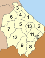 Narathiwat is subdivided into 13 districts (amphoe
), which are further subdivided into 77 subdistricts (tambon
) and 551 villages (muban
).
Local government entities within the province are the two towns (thesaban mueang) Narathiwat and Sungai Kolok, and 12 subdistrict municipalities (thesaban tambon).
, and Pattani
. Most of the inhabitants of these provinces also are ethnic Malay
s. The violent mujahideen
activity has been occurring since the 1980s. While the population may not support the separatists, many are nevertheless disaffected by the perceived heavy-handedness of the crackdown on the mujahideen by the central government.
On October 26, 2004, 78 Narathiwat Muslims suffocated after being arrested and stacked in police trucks in Tak Bai
, allegedly for taking part in riots around the province.
On June 8, 2009, at least 10 people died in a shooting during the Muslim evening prayers. Five or six gunmen disguised themselves with ski masks and attacked a Mosque. The army in Thailand
has denied involvement in the shooting.
is located on Pitchitbamrung Road, Tambon
Bangnark, Amphoe
Muang, about 1 kilometer from the provincial town. This mosque is the center of Thai Muslims who come to do their religious practice on Friday. It was built in 1981 in a three-storied Arabian-style building with a high tower and a domed roof as other mosques. The tower is used to call Muslims to prayer. It has been perfectly constructed by applying modern art blended with classical art intrigue.
The main attraction in this site is a graceful southern Buddha image, the golden “Pra Buddha Thaksin Ming Monkol”, which is seated in the lotus position and giving posture. “This mountaintop Buddha image which is considered to be the most beautiful and largest (17 meters wide and 24 meters high) outdoor Buddha image in southern Thailand is decorated in the South Indian style”. It is highly respected by locals and Buddhists in the South.
Provinces of Thailand
Thailand is divided into 76 provinces , which are geographically grouped into 6 regions. The capital Bangkok is not a province but a special administrative area and is included as the 77th province since it is administered at the same level as the other 76 provinces. The name of the provinces are...
(changwat) of Thailand
Thailand
Thailand , officially the Kingdom of Thailand , formerly known as Siam , is a country located at the centre of the Indochina peninsula and Southeast Asia. It is bordered to the north by Burma and Laos, to the east by Laos and Cambodia, to the south by the Gulf of Thailand and Malaysia, and to the...
. Neighboring provinces are (from west clockwise) Yala
Yala Province
Yala is the southernmost province of Thailand. Neighboring provinces are Songkhla, Pattani and Narathiwat. Yala is the only land-locked province in the south of Thailand...
and Pattani
Pattani Province
Pattani is one of the southern provinces of Thailand. Neighboring provinces are Narathiwat, Yala and Songkhla.-Geography:...
. To the south it borders the Malaysian state of Kelantan
Kelantan
Kelantan is a state of Malaysia. The capital and royal seat is Kota Bharu. The Arabic honorific of the state is Darul Naim, ....
. The southern railway line ends in this province that is one of the nation’s five provinces that borders Malaysia. The name of this province means “the residence of good people”. The province features a range of cultures as well as natural resources, and is relatively fertile. Narathiwat is located some 1,140 kilometers south of Bangkok
Bangkok
Bangkok is the capital and largest urban area city in Thailand. It is known in Thai as Krung Thep Maha Nakhon or simply Krung Thep , meaning "city of angels." The full name of Bangkok is Krung Thep Mahanakhon Amon Rattanakosin Mahintharayutthaya Mahadilok Phop Noppharat Ratchathani Burirom...
and occupies an area of 4,475 square kilometers. Seventy five percent of the area is jungles and mountains. The area has a tropical climate.
Geography
Narathiwat province is located on the Gulf of ThailandGulf of Thailand
The Gulf of Thailand , also known in to Malays as Teluk Siam literally meant Gulf of Siam, is a shallow arm of the South China Sea.-Geography:...
, on the Malay Peninsula
Malay Peninsula
The Malay Peninsula or Thai-Malay Peninsula is a peninsula in Southeast Asia. The land mass runs approximately north-south and, at its terminus, is the southern-most point of the Asian mainland...
. The Bang Nara is the main river and enters the Gulf of Thailand
Gulf of Thailand
The Gulf of Thailand , also known in to Malays as Teluk Siam literally meant Gulf of Siam, is a shallow arm of the South China Sea.-Geography:...
at the town of Narathiwat. Narathat beach, the most popular in the province, is near the estuary.
Budo - Su-ngai Padi National Park is located within the Sankalakhiri mountain range
Sankalakhiri mountain range
The Sankalakhiri mountain range is the natural border between Thailand and Malaysia.This mountain range is a part of the Tenasserim Hills system...
. Established in 1974, the park covers an area of 294 km², extending into neighbouring Yala and Pattani province. The main attraction is Pacho Waterfall.
Etymology
The original name of Narathiwat was Menara (Jawi: منارا), meaning a 'tower' in MalayMalay language
Malay is a major language of the Austronesian family. It is the official language of Malaysia , Indonesia , Brunei and Singapore...
. This was changed to Bang Nara (บางนรา) in Thai. It was finally changed to Narathiwat by King Rama VI in 1915. "Narathiwat", from the Sanskrit
Sanskrit
Sanskrit , is a historical Indo-Aryan language and the primary liturgical language of Hinduism, Jainism and Buddhism.Buddhism: besides Pali, see Buddhist Hybrid Sanskrit Today, it is listed as one of the 22 scheduled languages of India and is an official language of the state of Uttarakhand...
(Nara+adhivāsa), means the residence of wise people.
History
Historically Narathiwat was the part of the semi-independent MalayMalay people
Malays are an ethnic group of Austronesian people predominantly inhabiting the Malay Peninsula, including the southernmost parts of Thailand, the east coast of Sumatra, the coast of Borneo, and the smaller islands which lie between these locations...
Sultanate of Patani, paying tribute to the Thai kingdoms of Sukhothai
Sukhothai kingdom
The Sukhothai Kingdom ) was an early kingdom in the area around the city Sukhothai, in north central Thailand. The Kingdom existed from 1238 till 1438...
and Ayutthaya
Ayutthaya kingdom
Ayutthaya was a Siamese kingdom that existed from 1350 to 1767. Ayutthaya was friendly towards foreign traders, including the Chinese, Vietnamese , Indians, Japanese and Persians, and later the Portuguese, Spanish, Dutch and French, permitting them to set up villages outside the walls of the...
. After Ayutthaya fell in 1767, Sultanate of Patani gained full independence, but under King Rama I it again came under Thai control some 20 years later.
In 1909, Narathiwat was fully integrated into Siam as part of Anglo-Siamese Treaty of 1909
Anglo-Siamese Treaty of 1909
The Anglo-Siamese Treaty of 1909 or Bangkok Treaty of 1909 was a treaty between the United Kingdom and the Kingdom of Siam signed on March 10, 1909, in Bangkok. Ratifications were exchanged in London on July 9, 1909....
negotiated with the British Empire
British Empire
The British Empire comprised the dominions, colonies, protectorates, mandates and other territories ruled or administered by the United Kingdom. It originated with the overseas colonies and trading posts established by England in the late 16th and early 17th centuries. At its height, it was the...
. Along with Yala, Narathiwat was then part of Monthon Pattani. There is a small but active separatist movement, which after being dormant for many years erupted again in 2004.
Demographics
Narathiwat is one of the four Thai provinces which have a MuslimMuslim
A Muslim, also spelled Moslem, is an adherent of Islam, a monotheistic, Abrahamic religion based on the Quran, which Muslims consider the verbatim word of God as revealed to prophet Muhammad. "Muslim" is the Arabic term for "submitter" .Muslims believe that God is one and incomparable...
majority; 82% are Muslim and only 17.9% are Buddhist. Also 80.4% speak the Patani Malay as their first language. Narathiwat Malays are very similar in ethnicity and culture to the Malays of Kelantan
Kelantan
Kelantan is a state of Malaysia. The capital and royal seat is Kota Bharu. The Arabic honorific of the state is Darul Naim, ....
, Malaysia.
The inhabitants of Narathiwat are largely farmers and fishermen. On account of the religion, Narathiwat is an area with various religious places to go sightseeing.
Symbols
The provincial sealSeals of The Provinces of Thailand
-Present-day provinces of Thailand:This list includes all the seals of the Provinces of Thailand. It also includes the special administrative area of the capital, Bangkok.-Former Provinces:-External links:*...
shows a sailing boat with a white elephant
White elephant
A white elephant is an idiom for a valuable but burdensome possession of which its owner cannot dispose and whose cost is out of proportion to its usefulness or worth...
on the sail. A white elephant is a royal symbol, and was put on the seal to commemorate the white elephant Phra Sri Nararat Rajakarini which was caught here and presented to the king.
The provincial symbol is the longkong fruit (Lansium domesticum
Lansium domesticum
Lansium domesticum, also known as langsat or lanzones, is a fruit from the family Meliaceae. The plant, which originates from western Southeast Asia. It is the provincial flower for the Indonesian province of South Sumatra.-Names:...
). The provincial tree is the Chengal (Neobalanocarpus heimii
Neobalanocarpus heimii
Neobalanocarpus heimii is a species of plant in the Dipterocarpaceae family. It is found in Malaysia, Singapore, and Thailand.-Source:* Chua, L.S.L. 1998. . Downloaded on 22 August 2007....
), and the provincial flower is the Odontadenia macrantha.
Administrative divisions
Amphoe
An amphoe is the second level administrative subdivision of Thailand. Usually translated as district, amphoe make up the provinces, and are analogous to a county seat...
), which are further subdivided into 77 subdistricts (tambon
Tambon
Tambon is a local government unit in Thailand. Below district and province , they form the third administrative subdivision level. As of the 2009 there are 7255 tambon, not including the 169 khwaeng of Bangkok, which are set at the same administrative level, thus every district contains 8-10 tambon...
) and 551 villages (muban
Muban
Muban is the lowest administrative subdivision of Thailand. Usually translated as village, they are the subdivision of tambon. As of 2008, there are 74944 administrative villages in Thailand. As of the 1990 census, the average village consisted of 144 households or 746 persons.A muban does not...
).
|
|
Local government entities within the province are the two towns (thesaban mueang) Narathiwat and Sungai Kolok, and 12 subdistrict municipalities (thesaban tambon).
Recent history
There has been unrest in southern Thailand since January 4, 2004, especially in the majority Muslim provinces of Narathiwat, YalaYala Province
Yala is the southernmost province of Thailand. Neighboring provinces are Songkhla, Pattani and Narathiwat. Yala is the only land-locked province in the south of Thailand...
, and Pattani
Pattani Province
Pattani is one of the southern provinces of Thailand. Neighboring provinces are Narathiwat, Yala and Songkhla.-Geography:...
. Most of the inhabitants of these provinces also are ethnic Malay
Malay people
Malays are an ethnic group of Austronesian people predominantly inhabiting the Malay Peninsula, including the southernmost parts of Thailand, the east coast of Sumatra, the coast of Borneo, and the smaller islands which lie between these locations...
s. The violent mujahideen
Mujahideen
Mujahideen are Muslims who struggle in the path of God. The word is from the same Arabic triliteral as jihad .Mujahideen is also transliterated from Arabic as mujahedin, mujahedeen, mudžahedin, mudžahidin, mujahidīn, mujaheddīn and more.-Origin of the concept:The beginnings of Jihad are traced...
activity has been occurring since the 1980s. While the population may not support the separatists, many are nevertheless disaffected by the perceived heavy-handedness of the crackdown on the mujahideen by the central government.
On October 26, 2004, 78 Narathiwat Muslims suffocated after being arrested and stacked in police trucks in Tak Bai
Amphoe Tak Bai
Tak Bai is a district in the southeastern part of Narathiwat Province, southern Thailand.-History:When the United Kingdom and Siam made the Anglo-Siamese Treaty of 1909, they agreed to use the Kolok River nearby Wat Chonthara Singhe as the boundary between British Malaya and Siam due to the...
, allegedly for taking part in riots around the province.
On June 8, 2009, at least 10 people died in a shooting during the Muslim evening prayers. Five or six gunmen disguised themselves with ski masks and attacked a Mosque. The army in Thailand
Thailand
Thailand , officially the Kingdom of Thailand , formerly known as Siam , is a country located at the centre of the Indochina peninsula and Southeast Asia. It is bordered to the north by Burma and Laos, to the east by Laos and Cambodia, to the south by the Gulf of Thailand and Malaysia, and to the...
has denied involvement in the shooting.
Central Mosque of Narathiwat
The important religious site for Muslims is the Central Mosque of Narathiwat. This mosqueMosque
A mosque is a place of worship for followers of Islam. The word is likely to have entered the English language through French , from Portuguese , from Spanish , and from Berber , ultimately originating in — . The Arabic word masjid literally means a place of prostration...
is located on Pitchitbamrung Road, Tambon
Tambon
Tambon is a local government unit in Thailand. Below district and province , they form the third administrative subdivision level. As of the 2009 there are 7255 tambon, not including the 169 khwaeng of Bangkok, which are set at the same administrative level, thus every district contains 8-10 tambon...
Bangnark, Amphoe
Amphoe
An amphoe is the second level administrative subdivision of Thailand. Usually translated as district, amphoe make up the provinces, and are analogous to a county seat...
Muang, about 1 kilometer from the provincial town. This mosque is the center of Thai Muslims who come to do their religious practice on Friday. It was built in 1981 in a three-storied Arabian-style building with a high tower and a domed roof as other mosques. The tower is used to call Muslims to prayer. It has been perfectly constructed by applying modern art blended with classical art intrigue.
Khao Kong Buddhist Park
As has already been noted, 17.9 percent of the people in Narathiwat are Buddhist. Although it is a minority of the people, there are also Buddhist places in the same Amphoe of the mosque. The most famous one is Khao Kong Buddhist Park that occupies an area of 142 rai (227200 square metres (2,445,560.4 sq ft)) in Tambon Lamphu about 9 kilometers from town on the Narathiwat-Rangae Road.Pra Buddha Thaksin Ming Monkol
The main attraction in this site is a graceful southern Buddha image, the golden “Pra Buddha Thaksin Ming Monkol”, which is seated in the lotus position and giving posture. “This mountaintop Buddha image which is considered to be the most beautiful and largest (17 meters wide and 24 meters high) outdoor Buddha image in southern Thailand is decorated in the South Indian style”. It is highly respected by locals and Buddhists in the South.
Airlines
The direct flights fly from Bangkok to Narathiwat everyday. Currently, the services is operated by two airlines from two different airport.Nok Airlines
- Don Mueang (DMK) 10:10 am arr. NarathiwatNarathiwat AirportNarathiwat Airport is an airport in Narathiwat Province, Thailand.-Domestic Airlines:...
(NAW) 11:40 am (daily) - NarathiwatNarathiwat AirportNarathiwat Airport is an airport in Narathiwat Province, Thailand.-Domestic Airlines:...
(NAW) 12:10 am arr. Don Mueang (DMK) 1:40 pm (daily)
Air Asia
- SuvarnabhumiSuvarnabhumi AirportSuvarnabhumi Airport , also known as Bangkok International Airport, is an international airport serving Bangkok, Thailand. It was officially opened for limited domestic flight service on 15 September 2006, and opened for most domestic and all international commercial flights on 28 September...
(BKK) 10:30 am arr. NarathiwatNarathiwat AirportNarathiwat Airport is an airport in Narathiwat Province, Thailand.-Domestic Airlines:...
(NAW) 12:00 am (daily) - NarathiwatNarathiwat AirportNarathiwat Airport is an airport in Narathiwat Province, Thailand.-Domestic Airlines:...
(NAW) 12:25 am arr. SuvarnabhumiSuvarnabhumi AirportSuvarnabhumi Airport , also known as Bangkok International Airport, is an international airport serving Bangkok, Thailand. It was officially opened for limited domestic flight service on 15 September 2006, and opened for most domestic and all international commercial flights on 28 September...
(BKK) 1:50 pm (daily)
External links
- http://www.narathiwat.go.th/ Website of province (Thai)
- Province page from the Tourist Authority of Thailand