
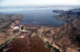
Painted Rock Reservoir, Arizona
Encyclopedia
The Painted Rock Dam is an earthfill embankment dam
located west of Gila Bend
, Arizona
. It is primarily used for flood
control purposes.
to help control seasonal floods on the lower reaches of the Gila River
. The river had no significant impediments between the Colorado River
and the Coolidge Dam
hundreds of miles upstream. As the river receives several tributaries, including the Hassayampa
, Agua Fria river
s, and most importantly the Salt River
and its major tributary, the Verde River
. Due to a relatively large watershed of 50800 square miles (131,571.4 km²), more than half of which is unregulated, the flood threat to small farming communities downstream on the Gila River is large, and seasonal flooding of these areas prior to the construction of the dam was significant.
The area surrounding the dam has also hosted a number of historical events. The Butterfield Overland Mail
route passed through the area, as did the path followed by the Mormon Battalion
. Evidence of both can be found, as well as the expedition of Juan Bautista De Anza
in 1774. Inscriptions made by these groups can be found in various sites in the region. Near the dam site, there is also a campground maintained by the Bureau of Land Management
that showcases a number of prehistoric petroglyph
s, indicating human involvement in the region long predating Western influence.
The lake and reservoir are dry as of August 2009 and are closed to the public due to contamination of pesticide run off. This is in stark contrast to the level of upkeep during the 1990s. The state was forced to abandon the campground and the area is now marked as "NO TRESPASSING". No hunting, hiking, or camping is allowed. The Army Corps of Engineers now maintains the property.
impounded by the Painted Rock Dam. The reservoir, with a maximum storage capacity of 2491700 acre.ft, has the potential to be the largest reservoir completely within the borders of the state of Arizona, but because the Gila River and its main tributary, the Salt River, are generally almost always completely diverted for irrigation and municipal water use for Phoenix, the lake is often dry.
In 2005, heavy runoff filled the reservoir to record levels, swelling the lake to become the second largest by area in the state of Arizona, trailing only Theodore Roosevelt Lake
. However, extremely high levels of pesticide
s, particularly the now-banned DDT
, had built up in the farmlands upstream from the reservoir in the decades prior and accumulated in the lake during the flood. The extreme toxicity of the lake rendered it unsuitable for recreational uses and public access to both the lake and the dam was restricted. Similar runoff had filled the lake previously in 1993 and 1980, and in each instance the lake persisted only a few months before emptying due to losses through evaporation, downstream releases, and infiltration.
's Gila Bend Reservation. The flooding destroyed a 750-acre tribal farm and several communities. Residents were relocated to a 40 acre parcel called San Lucy Village, Arizona. In 1986, the federal government and the Nation approved a settlement in which the Nation agreed to give up its legal claims in exchange for $30,000,000 and the right to add up to 10,000 acres of newly purchased land to its Reservation.
Embankment dam
An embankment dam is a massive artificial water barrier. It is typically created by the emplacement and compaction of a complex semi-plastic mound of various compositions of soil, sand, clay and/or rock. It has a semi-permanent waterproof natural covering for its surface, and a dense, waterproof...
located west of Gila Bend
Gila Bend, Arizona
Gila Bend , founded in 1872, is a town in Maricopa County, Arizona, United States. The town is named for an approximately 90-degree bend in the Gila River, which is close to but not precisely at the community's current location...
, Arizona
Arizona
Arizona ; is a state located in the southwestern region of the United States. It is also part of the western United States and the mountain west. The capital and largest city is Phoenix...
. It is primarily used for flood
Flood
A flood is an overflow of an expanse of water that submerges land. The EU Floods directive defines a flood as a temporary covering by water of land not normally covered by water...
control purposes.
Description
The Painted Rock Dam was constructed during a 3 year period from 1957-1960 by the United States Army Corps of EngineersUnited States Army Corps of Engineers
The United States Army Corps of Engineers is a federal agency and a major Army command made up of some 38,000 civilian and military personnel, making it the world's largest public engineering, design and construction management agency...
to help control seasonal floods on the lower reaches of the Gila River
Gila River
The Gila River is a tributary of the Colorado River, 650 miles long, in the southwestern states of New Mexico and Arizona.-Description:...
. The river had no significant impediments between the Colorado River
Colorado River
The Colorado River , is a river in the Southwestern United States and northwestern Mexico, approximately long, draining a part of the arid regions on the western slope of the Rocky Mountains. The watershed of the Colorado River covers in parts of seven U.S. states and two Mexican states...
and the Coolidge Dam
Coolidge Dam
The Coolidge Dam is a reinforced concrete multiple dome and buttress dam southeast of Globe, Arizona on the Gila River. Built between 1924 and 1928, the Coolidge Dam was part of the San Carlos Irrigation Project. Coolidge Dam was named after the 30th US President, Calvin Coolidge and was dedicated...
hundreds of miles upstream. As the river receives several tributaries, including the Hassayampa
Hassayampa River
The Hassayampa River is a mostly underground river, the headwaters of which are just south of Prescott, Arizona, and flows mostly south towards Wickenburg entering the Gila River near Hassayampa, Arizona...
, Agua Fria river
River
A river is a natural watercourse, usually freshwater, flowing towards an ocean, a lake, a sea, or another river. In a few cases, a river simply flows into the ground or dries up completely before reaching another body of water. Small rivers may also be called by several other names, including...
s, and most importantly the Salt River
Salt River (Arizona)
The Salt River is a stream in the U.S. state of Arizona. It is the largest tributary of the Gila River. The river is about long. Its drainage basin is about large. The longest of the Salt River's many tributaries is the Verde River...
and its major tributary, the Verde River
Verde River
The Verde River is the north and northwestern watershed of the Salt River–Verde River Watershed that co-join and enter the Gila River at Phoenix, Arizona, located in the U.S. state of Arizona...
. Due to a relatively large watershed of 50800 square miles (131,571.4 km²), more than half of which is unregulated, the flood threat to small farming communities downstream on the Gila River is large, and seasonal flooding of these areas prior to the construction of the dam was significant.
The area surrounding the dam has also hosted a number of historical events. The Butterfield Overland Mail
Butterfield Overland Mail
The Butterfield Overland Mail Trail was a stagecoach route in the United States, operating from 1857 to 1861. It was a conduit for the U.S. mail from two eastern termini, Memphis, Tennessee and St. Louis, Missouri, meeting Fort Smith, Arkansas, and continuing through Indian Territory, New Mexico,...
route passed through the area, as did the path followed by the Mormon Battalion
Mormon Battalion
The Mormon Battalion was the only religiously based unit in United States military history, and it served from July 1846 to July 1847 during the Mexican-American War. The battalion was a volunteer unit of between 534 and 559 Latter-day Saints men led by Mormon company officers, commanded by regular...
. Evidence of both can be found, as well as the expedition of Juan Bautista De Anza
Juan Bautista de Anza
Juan Bautista de Anza Bezerra Nieto was a Novo-Spanish explorer and Governor of New Mexico for the Spanish Empire.-Early life:...
in 1774. Inscriptions made by these groups can be found in various sites in the region. Near the dam site, there is also a campground maintained by the Bureau of Land Management
Bureau of Land Management
The Bureau of Land Management is an agency within the United States Department of the Interior which administers America's public lands, totaling approximately , or one-eighth of the landmass of the country. The BLM also manages of subsurface mineral estate underlying federal, state and private...
that showcases a number of prehistoric petroglyph
Petroglyph
Petroglyphs are pictogram and logogram images created by removing part of a rock surface by incising, picking, carving, and abrading. Outside North America, scholars often use terms such as "carving", "engraving", or other descriptions of the technique to refer to such images...
s, indicating human involvement in the region long predating Western influence.
The lake and reservoir are dry as of August 2009 and are closed to the public due to contamination of pesticide run off. This is in stark contrast to the level of upkeep during the 1990s. The state was forced to abandon the campground and the area is now marked as "NO TRESPASSING". No hunting, hiking, or camping is allowed. The Army Corps of Engineers now maintains the property.
Painted Rock Reservoir
The Painted Rock Reservoir is an artificial reservoirReservoir
A reservoir , artificial lake or dam is used to store water.Reservoirs may be created in river valleys by the construction of a dam or may be built by excavation in the ground or by conventional construction techniques such as brickwork or cast concrete.The term reservoir may also be used to...
impounded by the Painted Rock Dam. The reservoir, with a maximum storage capacity of 2491700 acre.ft, has the potential to be the largest reservoir completely within the borders of the state of Arizona, but because the Gila River and its main tributary, the Salt River, are generally almost always completely diverted for irrigation and municipal water use for Phoenix, the lake is often dry.
In 2005, heavy runoff filled the reservoir to record levels, swelling the lake to become the second largest by area in the state of Arizona, trailing only Theodore Roosevelt Lake
Theodore Roosevelt Lake
Theodore Roosevelt Lake is a large reservoir formed by Theodore Roosevelt Dam on the Salt River in Arizona as part of the Salt River Project...
. However, extremely high levels of pesticide
Pesticide
Pesticides are substances or mixture of substances intended for preventing, destroying, repelling or mitigating any pest.A pesticide may be a chemical unicycle, biological agent , antimicrobial, disinfectant or device used against any pest...
s, particularly the now-banned DDT
DDT
DDT is one of the most well-known synthetic insecticides. It is a chemical with a long, unique, and controversial history....
, had built up in the farmlands upstream from the reservoir in the decades prior and accumulated in the lake during the flood. The extreme toxicity of the lake rendered it unsuitable for recreational uses and public access to both the lake and the dam was restricted. Similar runoff had filled the lake previously in 1993 and 1980, and in each instance the lake persisted only a few months before emptying due to losses through evaporation, downstream releases, and infiltration.
Displacement of Native Americans
Water impounded by the Painted Rock Dam caused the flooding of about 10,000 acres of the Tohono O'odhamTohono O'odham
The Tohono O'odham are a group of Native American people who reside primarily in the Sonoran Desert of the southeastern Arizona and northwest Mexico...
's Gila Bend Reservation. The flooding destroyed a 750-acre tribal farm and several communities. Residents were relocated to a 40 acre parcel called San Lucy Village, Arizona. In 1986, the federal government and the Nation approved a settlement in which the Nation agreed to give up its legal claims in exchange for $30,000,000 and the right to add up to 10,000 acres of newly purchased land to its Reservation.