

Outline of South Dakota territorial evolution
Encyclopedia
Outline
- Historical territorial claims of the United KingdomUnited KingdomThe United Kingdom of Great Britain and Northern IrelandIn the United Kingdom and Dependencies, other languages have been officially recognised as legitimate autochthonous languages under the European Charter for Regional or Minority Languages...
in the present State of South Dakota:- Rupert's LandRupert's LandRupert's Land, or Prince Rupert's Land, was a territory in British North America, consisting of the Hudson Bay drainage basin that was nominally owned by the Hudson's Bay Company for 200 years from 1670 to 1870, although numerous aboriginal groups lived in the same territory and disputed the...
, 1670–1870- Anglo-American Convention of 1818
- Rupert's Land
- Historical territorial claims of FranceFranceThe French Republic , The French Republic , The French Republic , (commonly known as France , is a unitary semi-presidential republic in Western Europe with several overseas territories and islands located on other continents and in the Indian, Pacific, and Atlantic oceans. Metropolitan France...
in the present State of South Dakota:- LouisianeLouisiana (New France)Louisiana or French Louisiana was an administrative district of New France. Under French control from 1682–1763 and 1800–03, the area was named in honor of Louis XIV, by French explorer René-Robert Cavelier, Sieur de la Salle...
, 1682–1764- Treaty of Fontainebleau of 1762
- Louisiane
- Historical territorial claims of SpainSpainSpain , officially the Kingdom of Spain languages]] under the European Charter for Regional or Minority Languages. In each of these, Spain's official name is as follows:;;;;;;), is a country and member state of the European Union located in southwestern Europe on the Iberian Peninsula...
in the present State of South Dakota:- LuisianaLouisiana (New Spain)Louisiana was the name of an administrative district of the Viceroyalty of New Spain from 1764 to 1803 that represented territory west of the Mississippi River basin, plus New Orleans...
, 1764–1803- Third Treaty of San IldefonsoThird Treaty of San IldefonsoThe Third Treaty of San Ildefonso was a secretly negotiated treaty between France and Spain in which Spain returned the colonial territory of...
of 1800
- Third Treaty of San Ildefonso
- Luisiana
- Historical territorial claims of FranceFranceThe French Republic , The French Republic , The French Republic , (commonly known as France , is a unitary semi-presidential republic in Western Europe with several overseas territories and islands located on other continents and in the Indian, Pacific, and Atlantic oceans. Metropolitan France...
in the present State of South Dakota:- LouisianeLouisiana (New France)Louisiana or French Louisiana was an administrative district of New France. Under French control from 1682–1763 and 1800–03, the area was named in honor of Louis XIV, by French explorer René-Robert Cavelier, Sieur de la Salle...
, 1803- Vente de la Louisiane of 1803
- Louisiane
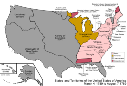
- Historical political divisions of the United StatesPolitical divisions of the United StatesThe political units and divisions of the United States include:*The 50 states are subdivided into counties . The counties may be further subdivided into townships, or towns in New York and New England...
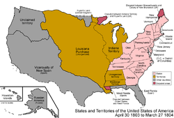
in the present State of South Dakota:- Unorganized territory created by the Louisiana PurchaseLouisiana PurchaseThe Louisiana Purchase was the acquisition by the United States of America of of France's claim to the territory of Louisiana in 1803. The U.S...
, 1803–1804 - District of LouisianaDistrict of LouisianaThe District of Louisiana, or Louisiana District, was an official, temporary, United States government designation for the portion of the Louisiana Purchase that had not been organized into the Orleans Territory. It officially existed from March 10, 1804 until July 4, 1805, when it was incorporated...
, 1804–1805 - Territory of Louisiana, 1805–1812
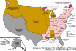
- Territory of Missouri, 1812–1821
- Unorganized territory formerly the northwestern Missouri Territory, 1821–1854
- Treaty of Fort Laramie of 1851Treaty of Fort Laramie (1851)Although many European and European-American migrants to western North America had previously passed through the Great Plains on the Oregon and Santa Fe Trails, the California gold rush greatly increased traffic...
- Treaty of Fort Laramie of 1851
- Territory of Michigan east of Missouri RiverMissouri RiverThe Missouri River flows through the central United States, and is a tributary of the Mississippi River. It is the longest river in North America and drains the third largest area, though only the thirteenth largest by discharge. The Missouri's watershed encompasses most of the American Great...
, 1805-(1834–1836)-1837 - Territory of Wisconsin east of Missouri RiverMissouri RiverThe Missouri River flows through the central United States, and is a tributary of the Mississippi River. It is the longest river in North America and drains the third largest area, though only the thirteenth largest by discharge. The Missouri's watershed encompasses most of the American Great...
, (1836–1838)-1848 - Territory of Iowa east of Missouri RiverMissouri RiverThe Missouri River flows through the central United States, and is a tributary of the Mississippi River. It is the longest river in North America and drains the third largest area, though only the thirteenth largest by discharge. The Missouri's watershed encompasses most of the American Great...
, 1838–1846 - Territory of Minnesota east of Missouri RiverMissouri RiverThe Missouri River flows through the central United States, and is a tributary of the Mississippi River. It is the longest river in North America and drains the third largest area, though only the thirteenth largest by discharge. The Missouri's watershed encompasses most of the American Great...
, 1849–1858 - Territory of Nebraska west of Missouri RiverMissouri RiverThe Missouri River flows through the central United States, and is a tributary of the Mississippi River. It is the longest river in North America and drains the third largest area, though only the thirteenth largest by discharge. The Missouri's watershed encompasses most of the American Great...
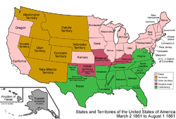
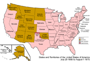
, (1854–1861)-1867 - Territory of Dakota, 1861-1889
- Land between the 43rd parallel north43rd parallel northThe 43rd parallel north is a circle of latitude that is 43 degrees north of the Earth's equatorial plane. It crosses Europe, the Mediterranean Sea, Asia, the Pacific Ocean, North America, and the Atlantic Ocean....
and Keya Paha RiverKeya Paha RiverThe Keya Paha River is a river flowing through the U.S. states of South Dakota and Nebraska.The name is derived from the Dakota language ke'-ya pa-ha, meaning "turtle hill"...
or Niobrara RiverNiobrara RiverThe Niobrara River is a tributary of the Missouri River, approximately long, running through the U.S. states of Wyoming and Nebraska. The river drains one of the most arid sections of the Great Plains, and has a low flow for a river of its length...
was transferred to the State of Nebraska, 1882
- Land between the 43rd parallel north
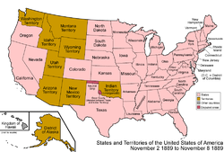
- State of South Dakota, since November 2, 1889
- Unorganized territory created by the Louisiana Purchase
See also
- Historical outline of South Dakota
- History of South DakotaHistory of South DakotaThe history of South Dakota describes the history of the U.S. state of South Dakota over the course of several millennia, from its first inhabitants to the recent issues facing the state.-Early inhabitants:...
- Territorial evolution of the United StatesTerritorial evolution of the United StatesThis is a list of the evolution of the borders of the United States. This lists each change to the internal and external borders of the country, as well as status and name changes. It also shows the surrounding areas that eventually became part of the United States...
 Territorial evolution of Iowa
 Territorial evolution of Minnesota
 Territorial evolution of Montana
 Territorial evolution of Nebraska
 Territorial evolution of North Dakota
 Territorial evolution of Wyoming