
Orleans Levee Board
Encyclopedia
From 1890 through 2006, the Orleans Levee Board was the body in charge of supervising the levee
and floodwall system in Orleans Parish, Louisiana, which is intended to protect the city of New Orleans
from flooding
. The role included requirements definition prior to construction, operation, and ongoing maintenance. Over the years the Board also took on various activities relating to land use on and around the levees. In the wake of the catastrophic engineering failures sustained by New Orleans' levee and floodwall system in the aftermath of Hurricane Katrina's landfall, two new regional flood protection authorities were created to supersede multiple parochial levee boards, including Orleans Parish's Levee Board. Most of the Orleans Levee District now falls under the jurisdiction of the Southeast Louisiana Flood Protection Authority-East, charged with the oversight of all flood protection infrastructure for Greater New Orleans
on the East Bank of the Mississippi River. The Southeast Louisiana Flood Protection Authority-West possesses the same metro-wide jurisdiction for the West Bank of the Mississippi, and includes that portion of the Orleans Levee District on the West Bank (i.e., Algiers).
Until the end of 2006, the Orleans Levee Board was a major governmental entity that functioned independently of municipal government in and around Orleans Parish, Louisiana. (Orleans Parish is coextensive with the city of New Orleans; their boundaries are one and the same). The purpose of the agency governed by the Orleans Levee Board, the Orleans Levee District, was to protect New Orleans from flooding, and to protect and operate the equipment placed and assigned for that purpose. Starting in the 1920s the Board undertook a massive flood protection initiative involving the construction of a stepped seawall several hundred feet north of a portion of the existing south shore of Lake Pontchartrain
. The intervening area was filled to several feet above sea level and was to serve as a "super levee" protecting the city from Lake Pontchartrain storm surge. This "lakefill" land reclamation project ultimately was developed to include Lakeshore Drive, the residential subdivisions of Lakeshore
, Lake Vista
, Lake Terrace
and Lake Oaks
, the principal campus of the University of New Orleans
("UNO"), the UNO Research & Technology Park, the New Orleans Lakefront Airport
, hundreds of acres of public parks, and a number of commercial areas. This project resulted in the Orleans Levee Board's deep engagement in land development, long-term leases, greenspace maintenance, marina operation and, once Louisiana legalized gaming in 1992, casino
gambling
. Such activities led critics of the Board to accuse its members of being more concerned with lucrative subsidiary activities than with what was their Board's primary assigned task (flood protection).
legislature in 1890 for the purpose of protecting the city of New Orleans from floods. At the time, communities along the Mississippi River
were largely in charge of creating their own levees to protect themselves, as no unified levee system existed. Most neighboring parishes had (and some still have) similar parochial levee boards.
In 1924, the state legislature authorized the levee district's Board of Commissioners ("the Levee Board") to acquire 33,000 acres (130 km²) of land on the east bank of the Mississippi River about 50 miles (80.5 km) south of New Orleans in order to build the Bohemia Spillway between the River and the Gulf of Mexico
. (1924 La. Acts 99). Approximately half of this land was public property transferred from the state; the other half was either expropriated
or purchased under threat of expropriation from private owners according to a legal finding. (1928 La. Acts 246; 1942 La. Acts 311).
In the aftermath of the Great Mississippi Flood of 1927
, the United States Congress
gave the United States Army Corps of Engineers
supervision and control of design and construction of flood control throughout the Mississippi Valley. Local levee boards remained, however, in charge of day-to-day inspection and maintenance of the levee systems in their areas.
In the 1934 New Orleans Lakefront Airport
opened on land dredged from Lake Pontchartrain
by the Levee Board, part of a larger "lakefill" land reclamation project initiated to construct a super levee to protect the northern perimeter of New Orleans. The airport was originally named "Shushan Airport" after Orleans Levee Board president Abraham Lazar Shushan; it was renamed "New Orleans Airport" after Shushan's indictment for corrupution in the Louisiana Scandals of the late 1930s.
In the wake of Hurricane Betsy
in 1965, Congress
directed the United States Army Corps of Engineers
to design and construct a network of levees and floodwalls for Greater New Orleans
sufficient to withstand a direct hit by a moderately strong hurricane, approximating Category 3 on the modern Saffir-Simpson scale
.
A 2002 lawsuit detailed the Orleans Levee Board's then-considerable independent financial means.
From the Levee Board's Legal Statement at trial:
 On Tuesday, August 30, 2005 the Orleans Levee Board was at the center of the greatest crisis ever to face the city of New Orleans when in the aftermath of Hurricane Katrina
multiple levee and floodwall breaches in the Industrial Canal
, 17th Street Canal
, and London Avenue Canal
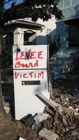
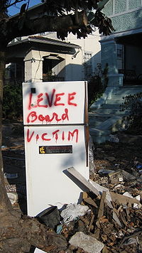
resulted in the flooding of some 80% of the city. The resulting flood is believed to have caused over 1,000 deaths, destroyed or severely damaged homes, businesses, and property in the majority of the city, and contributed to the emergence of lawlessness, looting and murder within the city of New Orleans in the days afterward.
Investigations after the disaster revealed the design of the levee and floodwall system, contracted and overseen by the United States Army Corps of Engineers
, to have been profoundly inadequate, and that the annual inspections of completed projects by the Orleans Levee Board were perfunctory at best. Legal investigations of possible criminal negligence are ongoing.
(D-Arabi)
, which consolidated the levee boards of various parishes within Greater New Orleans
. The law created two new regional levee boards, Southeast Louisiana Flood Protection Authority-East and Southeast Louisiana Flood Protection Authority-West, separated by the Mississippi River
.
The Orleans Levee Board ceased to exist on January 1, 2007. The new regional flood protection authorities assumed control of the Board's flood protection infrastructure. Lakefront Airport, the marinas (except for the city-owned Municipal Yacht Harbor), Lakeshore Drive and the lakefront park system (except for West End Park, administered by New Orleans' Parks and Parkways Department) are now operated and maintained by the Louisiana State Division of Administration Non-Flood Protection Asset Management Authority.
Levee
A levee, levée, dike , embankment, floodbank or stopbank is an elongated naturally occurring ridge or artificially constructed fill or wall, which regulates water levels...
and floodwall system in Orleans Parish, Louisiana, which is intended to protect the city of New Orleans
New Orleans, Louisiana
New Orleans is a major United States port and the largest city and metropolitan area in the state of Louisiana. The New Orleans metropolitan area has a population of 1,235,650 as of 2009, the 46th largest in the USA. The New Orleans – Metairie – Bogalusa combined statistical area has a population...
from flooding
Flood
A flood is an overflow of an expanse of water that submerges land. The EU Floods directive defines a flood as a temporary covering by water of land not normally covered by water...
. The role included requirements definition prior to construction, operation, and ongoing maintenance. Over the years the Board also took on various activities relating to land use on and around the levees. In the wake of the catastrophic engineering failures sustained by New Orleans' levee and floodwall system in the aftermath of Hurricane Katrina's landfall, two new regional flood protection authorities were created to supersede multiple parochial levee boards, including Orleans Parish's Levee Board. Most of the Orleans Levee District now falls under the jurisdiction of the Southeast Louisiana Flood Protection Authority-East, charged with the oversight of all flood protection infrastructure for Greater New Orleans
New Orleans metropolitan area
New Orleans–Metairie–Kenner, or the Greater New Orleans Region is a metropolitan area designated by the United States Census encompassing seven parishes in the state of Louisiana, centering on the city of New Orleans...
on the East Bank of the Mississippi River. The Southeast Louisiana Flood Protection Authority-West possesses the same metro-wide jurisdiction for the West Bank of the Mississippi, and includes that portion of the Orleans Levee District on the West Bank (i.e., Algiers).
Until the end of 2006, the Orleans Levee Board was a major governmental entity that functioned independently of municipal government in and around Orleans Parish, Louisiana. (Orleans Parish is coextensive with the city of New Orleans; their boundaries are one and the same). The purpose of the agency governed by the Orleans Levee Board, the Orleans Levee District, was to protect New Orleans from flooding, and to protect and operate the equipment placed and assigned for that purpose. Starting in the 1920s the Board undertook a massive flood protection initiative involving the construction of a stepped seawall several hundred feet north of a portion of the existing south shore of Lake Pontchartrain
Lake Pontchartrain
Lake Pontchartrain is a brackish estuary located in southeastern Louisiana. It is the second-largest inland saltwater body of water in the United States, after the Great Salt Lake in Utah, and the largest lake in Louisiana. As an estuary, Pontchartrain is not a true lake.It covers an area of with...
. The intervening area was filled to several feet above sea level and was to serve as a "super levee" protecting the city from Lake Pontchartrain storm surge. This "lakefill" land reclamation project ultimately was developed to include Lakeshore Drive, the residential subdivisions of Lakeshore
Lakeshore/Lake Vista, New Orleans
Lakeshore/Lake Vista is a neighborhood of the city of New Orleans. A subdistrict of the Lakeview District Area, its boundaries as defined by the City Planning Commission are: Lake Pontchartrain to the north, Bayou St. John to the east, Robert E. Lee Boulevard to the south and Pontchartrain...
, Lake Vista
Lakeshore/Lake Vista, New Orleans
Lakeshore/Lake Vista is a neighborhood of the city of New Orleans. A subdistrict of the Lakeview District Area, its boundaries as defined by the City Planning Commission are: Lake Pontchartrain to the north, Bayou St. John to the east, Robert E. Lee Boulevard to the south and Pontchartrain...
, Lake Terrace
Lake Terrace/Lake Oaks, New Orleans
Lake Terrace/Lake Oaks is a neighborhood of the city of New Orleans. A subdistrict of the city's Gentilly District Area, its boundaries as defined by the City Planning Commission are: Lake Pontchartrain to the north, the Industrial Canal to the east, Leon C. Simon Drive, Elysian Fields Avenue, New...
and Lake Oaks
Lake Terrace/Lake Oaks, New Orleans
Lake Terrace/Lake Oaks is a neighborhood of the city of New Orleans. A subdistrict of the city's Gentilly District Area, its boundaries as defined by the City Planning Commission are: Lake Pontchartrain to the north, the Industrial Canal to the east, Leon C. Simon Drive, Elysian Fields Avenue, New...
, the principal campus of the University of New Orleans
University of New Orleans
The University of New Orleans, often referred to locally as UNO, is a medium-sized public urban university located on the New Orleans Lakefront within New Orleans, Louisiana, United States. It is a member of the LSU System and the Urban 13 association. Currently UNO is without a proper chancellor...
("UNO"), the UNO Research & Technology Park, the New Orleans Lakefront Airport
New Orleans Lakefront Airport
Lakefront Airport is a public use airport located four nautical miles northeast of the central business district of New Orleans, in Orleans Parish, Louisiana, United States...
, hundreds of acres of public parks, and a number of commercial areas. This project resulted in the Orleans Levee Board's deep engagement in land development, long-term leases, greenspace maintenance, marina operation and, once Louisiana legalized gaming in 1992, casino
Casino
In modern English, a casino is a facility which houses and accommodates certain types of gambling activities. Casinos are most commonly built near or combined with hotels, restaurants, retail shopping, cruise ships or other tourist attractions...
gambling
Gambling
Gambling is the wagering of money or something of material value on an event with an uncertain outcome with the primary intent of winning additional money and/or material goods...
. Such activities led critics of the Board to accuse its members of being more concerned with lucrative subsidiary activities than with what was their Board's primary assigned task (flood protection).
History
The Orleans Levee District was created by the LouisianaLouisiana
Louisiana is a state located in the southern region of the United States of America. Its capital is Baton Rouge and largest city is New Orleans. Louisiana is the only state in the U.S. with political subdivisions termed parishes, which are local governments equivalent to counties...
legislature in 1890 for the purpose of protecting the city of New Orleans from floods. At the time, communities along the Mississippi River
Mississippi River
The Mississippi River is the largest river system in North America. Flowing entirely in the United States, this river rises in western Minnesota and meanders slowly southwards for to the Mississippi River Delta at the Gulf of Mexico. With its many tributaries, the Mississippi's watershed drains...
were largely in charge of creating their own levees to protect themselves, as no unified levee system existed. Most neighboring parishes had (and some still have) similar parochial levee boards.
In 1924, the state legislature authorized the levee district's Board of Commissioners ("the Levee Board") to acquire 33,000 acres (130 km²) of land on the east bank of the Mississippi River about 50 miles (80.5 km) south of New Orleans in order to build the Bohemia Spillway between the River and the Gulf of Mexico
Gulf of Mexico
The Gulf of Mexico is a partially landlocked ocean basin largely surrounded by the North American continent and the island of Cuba. It is bounded on the northeast, north and northwest by the Gulf Coast of the United States, on the southwest and south by Mexico, and on the southeast by Cuba. In...
. (1924 La. Acts 99). Approximately half of this land was public property transferred from the state; the other half was either expropriated
or purchased under threat of expropriation from private owners according to a legal finding. (1928 La. Acts 246; 1942 La. Acts 311).
In the aftermath of the Great Mississippi Flood of 1927
Great Mississippi Flood of 1927
The Great Mississippi Flood of 1927 was the most destructive river flood in the history of the United States.-Events:The flood began when heavy rains pounded the central basin of the Mississippi in the summer of 1926. By September, the Mississippi's tributaries in Kansas and Iowa were swollen to...
, the United States Congress
United States Congress
The United States Congress is the bicameral legislature of the federal government of the United States, consisting of the Senate and the House of Representatives. The Congress meets in the United States Capitol in Washington, D.C....
gave the United States Army Corps of Engineers
United States Army Corps of Engineers
The United States Army Corps of Engineers is a federal agency and a major Army command made up of some 38,000 civilian and military personnel, making it the world's largest public engineering, design and construction management agency...
supervision and control of design and construction of flood control throughout the Mississippi Valley. Local levee boards remained, however, in charge of day-to-day inspection and maintenance of the levee systems in their areas.
In the 1934 New Orleans Lakefront Airport
New Orleans Lakefront Airport
Lakefront Airport is a public use airport located four nautical miles northeast of the central business district of New Orleans, in Orleans Parish, Louisiana, United States...
opened on land dredged from Lake Pontchartrain
Lake Pontchartrain
Lake Pontchartrain is a brackish estuary located in southeastern Louisiana. It is the second-largest inland saltwater body of water in the United States, after the Great Salt Lake in Utah, and the largest lake in Louisiana. As an estuary, Pontchartrain is not a true lake.It covers an area of with...
by the Levee Board, part of a larger "lakefill" land reclamation project initiated to construct a super levee to protect the northern perimeter of New Orleans. The airport was originally named "Shushan Airport" after Orleans Levee Board president Abraham Lazar Shushan; it was renamed "New Orleans Airport" after Shushan's indictment for corrupution in the Louisiana Scandals of the late 1930s.
In the wake of Hurricane Betsy
Hurricane Betsy
Hurricane Betsy was a Category 4 hurricane of the 1965 Atlantic hurricane season which caused enormous damage in the Bahamas, Florida, and Louisiana. Betsy made its most intense landfall near the mouth of the Mississippi River, causing significant flooding of the waters of Lake Pontchartrain into...
in 1965, Congress
United States Congress
The United States Congress is the bicameral legislature of the federal government of the United States, consisting of the Senate and the House of Representatives. The Congress meets in the United States Capitol in Washington, D.C....
directed the United States Army Corps of Engineers
United States Army Corps of Engineers
The United States Army Corps of Engineers is a federal agency and a major Army command made up of some 38,000 civilian and military personnel, making it the world's largest public engineering, design and construction management agency...
to design and construct a network of levees and floodwalls for Greater New Orleans
New Orleans metropolitan area
New Orleans–Metairie–Kenner, or the Greater New Orleans Region is a metropolitan area designated by the United States Census encompassing seven parishes in the state of Louisiana, centering on the city of New Orleans...
sufficient to withstand a direct hit by a moderately strong hurricane, approximating Category 3 on the modern Saffir-Simpson scale
Saffir-Simpson Hurricane Scale
The Saffir–Simpson Hurricane Scale , or the Saffir–Simpson Hurricane Wind Scale , classifies hurricanes — Western Hemisphere tropical cyclones that exceed the intensities of tropical depressions and tropical storms — into five categories distinguished by the intensities of their sustained winds...
.
A 2002 lawsuit detailed the Orleans Levee Board's then-considerable independent financial means.
From the Levee Board's Legal Statement at trial:
- "With regard to the more general question of the levee district's budget, the Orleans Levee District receives very little funding from the state. The levee district generates its own revenues from the Lakefront AirportNew Orleans Lakefront AirportLakefront Airport is a public use airport located four nautical miles northeast of the central business district of New Orleans, in Orleans Parish, Louisiana, United States...
, a casino, leases of property, fees from boatslips and marinas, and taxes. The district also receives income from various investment accounts currently worth $57 million. The levee board does not dispute these facts. At oral argument, counsel for the levee board pointed out that the district receives some state funds, even though they are usually in the form of capital outlays dedicated to specific projects. Because the state funds are already earmarked for other purposes, the state monies cannot be used to pay a judgment against the levee district. See Hudson, 174 F.3d at 688-89."
The Levee Board and Hurricane Katrina
Hurricane Katrina
Hurricane Katrina of the 2005 Atlantic hurricane season was a powerful Atlantic hurricane. It is the costliest natural disaster, as well as one of the five deadliest hurricanes, in the history of the United States. Among recorded Atlantic hurricanes, it was the sixth strongest overall...
multiple levee and floodwall breaches in the Industrial Canal
Industrial Canal
The Industrial Canal is a 5.5 mile waterway in New Orleans, Louisiana, United States. The waterway's proper name, as used by the U.S. Army Corps of Engineers and on NOAA nautical charts, is Inner Harbor Navigation Canal...
, 17th Street Canal
17th Street Canal
The 17th Street Canal is a drainage canal in Greater New Orleans, Louisiana, that flows into Lake Pontchartrain. The canal forms a significant portion of the boundary between the city of New Orleans and Metairie, Louisiana...
, and London Avenue Canal
London Avenue Canal
The London Avenue Canal is a drainage canal in New Orleans, Louisiana, used for pumping rain water into Lake Pontchartrain. The Canal runs through the 7th Ward of New Orleans from the Gentilly area to the Lakefront....
resulted in the flooding of some 80% of the city. The resulting flood is believed to have caused over 1,000 deaths, destroyed or severely damaged homes, businesses, and property in the majority of the city, and contributed to the emergence of lawlessness, looting and murder within the city of New Orleans in the days afterward.
Investigations after the disaster revealed the design of the levee and floodwall system, contracted and overseen by the United States Army Corps of Engineers
United States Army Corps of Engineers
The United States Army Corps of Engineers is a federal agency and a major Army command made up of some 38,000 civilian and military personnel, making it the world's largest public engineering, design and construction management agency...
, to have been profoundly inadequate, and that the annual inspections of completed projects by the Orleans Levee Board were perfunctory at best. Legal investigations of possible criminal negligence are ongoing.
Governmental Reform
In the aftermath of the 2005 flooding, there were calls for the elimination of the Orleans Levee Board and other local and regional boards. During a special session of the Louisiana Legislature, a bill was passed into law by Sen. Walter BoassoWalter Boasso
Walter Joseph Boasso is a wealthy businessman and former Democratic state senator from Chalmette, the seat of St. Bernard Parish in south Louisiana. He was defeated in a bid for governor in the October 20, 2007, jungle primary. Boasso won 47 percent in his own St. Bernard Parish, his sole...
(D-Arabi)
Arabi, Louisiana
Arabi is a census-designated place in St. Bernard Parish, Louisiana on the East Bank of the Mississippi River, between the Lower 9th Ward of New Orleans, Louisiana and Chalmette within the Greater New Orleans Metropolitan area...
, which consolidated the levee boards of various parishes within Greater New Orleans
New Orleans metropolitan area
New Orleans–Metairie–Kenner, or the Greater New Orleans Region is a metropolitan area designated by the United States Census encompassing seven parishes in the state of Louisiana, centering on the city of New Orleans...
. The law created two new regional levee boards, Southeast Louisiana Flood Protection Authority-East and Southeast Louisiana Flood Protection Authority-West, separated by the Mississippi River
Mississippi River
The Mississippi River is the largest river system in North America. Flowing entirely in the United States, this river rises in western Minnesota and meanders slowly southwards for to the Mississippi River Delta at the Gulf of Mexico. With its many tributaries, the Mississippi's watershed drains...
.
The Orleans Levee Board ceased to exist on January 1, 2007. The new regional flood protection authorities assumed control of the Board's flood protection infrastructure. Lakefront Airport, the marinas (except for the city-owned Municipal Yacht Harbor), Lakeshore Drive and the lakefront park system (except for West End Park, administered by New Orleans' Parks and Parkways Department) are now operated and maintained by the Louisiana State Division of Administration Non-Flood Protection Asset Management Authority.