

Industrial Canal
Encyclopedia
The Industrial Canal is a 5.5 mile (9 km) waterway
in New Orleans, Louisiana
, United States
. The waterway's proper name, as used by the U.S. Army Corps of Engineers
and on NOAA nautical charts, is Inner Harbor Navigation Canal (IHNC). The more common "Industrial Canal" name is used locally, both by commercial mariners and by landside residents.
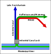
The canal connects the Mississippi River
to Lake Pontchartrain
. It separates New Orleans East
from the rest of the city of New Orleans, and the Lower 9th Ward from the Upper 9th Ward. Approximately half of the waterway's course, from Industrial Lock to a point north of the Florida Avenue Bridge
, is confluent
with both the Gulf Intracoastal Waterway
and the Mississippi River Gulf Outlet (MRGO).
The entirety of the canal passes through the 9th Ward
of the city. Along the riverfront, the canal constitutes the boundary of the Upper 9th Ward's Bywater neighborhood
on the upriver side of the canal and the Lower 9th Ward neighborhood on the downriver side. Near the lake, it is generally considered to be the eastern boundary of the Gentilly neighborhood
and the western boundary of New Orleans East
.
 The dream of a shipping canal connecting the Mississippi River to Lake Pontchartrain goes back to Spanish
colonial times (1763–1803). The colonial era Carondelet Canal
connected the back side of the French Quarter
with the lake via Bayou St. John
, but it was not extended to the river because of the differing levels of the river and the lake. Engineers confirmed that canal locks would be necessary.
 A canal proposed in the early 19th century was never built, but the right-of-way for the proposed waterway gave its name to the city's Canal Street
.
In July 1914 the Louisiana
State Government authorized the Port of New Orleans
to build a deep-water shipping canal between the river and lake. Considerable land was expropriated in the downriver portion of the city. Toward the lake this was mostly little-developed swamp. Along the riverfront, though, buildings demolished to make room for the canal included homes and the Ursuline Convent, whose Dauphine Street facility was nearly a century old at that time.
Dredging of the canal began on 6 June 1918. The length from the lake to the lock near the river was constructed with a 30 foot (9 m) depth, with a width of 300 feet (90 m) at the top of the canal and at least 150 feet (45 m) at the bottom. The original lock system had 5 gates, a width of 74 feet (23 m), and a depth of 50 feet (15 m), with a capability to function to up to 20 feet (6 m) in difference of levels between the river and lake. The opening dedication ceremony was presided over by Louisiana Governor John M. Parker
on 5 May 1923. The cost was 19 million dollars
.
The original length of the canal was 5.3 miles (8.5 km) with a 1,600 foot (500 m) right-of way. The longer current length of 5.5 miles (8.9 km) is due to the extension of the lakeshore by dredging in the late 1920s.
After the opening of the canal, slips and docks were added along its length, allowing it to function as a harbor
and industrial zone in addition to serving as a transit canal. With the inauguration of the Gulf Intracoastal Waterway
(GIWW) in the 1930s, the Industrial Canal served as a channel linking the Lake Pontchartrain segment of the GIWW to its continuing segment, accessed via the Mississippi River. During World War II the Intracoastal Waterway was rerouted, and a newly-excavated segment extending through the swamp west from the Rigolets
joined the Industrial Canal at its approximate midway point between the river and the lake. In 1944, the federal government leased the Industrial Canal lock and the southern 2.1-mile (3.4-km) section of the canal and took over its operation and maintenance.
In the 1960s the Industrial Canal/Intracoastal Waterway junction was enlarged, in expectation of the anticipated surge in traffic resulting from the completion (1965) of the Mississippi River Gulf Outlet
. Largely due to the failure of the Port of New Orleans'
Centroport U.S.A. initiative (which envisioned the wholesale relocation of the port from wharfs along the Mississippi River to new facilities along the Intracoastal Waterway), this surge in traffic failed to materialize.
s resulted in the flooding of the Lower 9th Ward during Hurricane Betsy
in 1965. Subsequently, concrete floodwalls were constructed to replace the levees.
In 2005, with the approach of Hurricane Katrina, storm surge funneled by the confluence of the GIWW's and MRGO's levees created multiple breaches in the canal's concrete floodwalls, including the spectacular failure of a quarter-mile length on the Lower 9th Ward side, resulting in catastrophic flooding. On the Upper 9th Ward side, the canal poured through a breach near Florida Avenue. On the opposite side, there were two breaches between Florida Avenue and Claiborne Avenue. A large barge, the ING 4727
, floated through the breach closer to the river and was deposited in the Lower 9th Ward. The barge itself may have caused one or more of the breaches; this possibility is under investigation. The canal lock was functioning two days after Katrina hit, at first mostly for barges bringing in fill to repair the breaches. A month later Hurricane Rita
reflooded recently drained areas along the canal by topping emergency fill at the breach sites.
in 2005, proposals have been made to close the northern end of the canal by building a dam
at the entrance to Lake Pontchartrain, as part of an effort to block storm surge
. A subcommittee of the Bring New Orleans Back Commission
has endorsed such a move. Since a dam would prohibit shipping between the lake and the canal, the US Army Corps of Engineers has designed a surge barrier
, the IHNC Seabrook Floodgate Structure. Construction started in the fall of 2010, and although construction activities will continue beyond the Corps' projected June 1, 2011 deadline, a temporary cofferdam
has been built to reduce risk to the area during the construction.
, the IHNC Lake Borgne Surge Barrier
is under construction near the confluence of the GIWW and MRGO. This $1.1 billion project is expected to be finished in 2011. The barrier will have navigable gates in the GIWW and Bayou Bienvenue
. These gates can be shut when a storm surge is expected.
provides a connection with the Mississippi river. Because it is shorter and narrower than most modern locks on the Mississippi River System
, the 1920s vintage lock has become a bottleneck between the nation's two highest-tonnage waterways
—the Mississippi and the Gulf Intracoastal Waterway
.
The U.S. Army Corps of Engineers is engaged in a project to replace the canal's historic locks
with larger modern locks sited to the north of Claiborne Avenue.
Maritime interests argue that in light of the closure of the MRGO, and the loss of the deepwater access it provided to the Gulf of Mexico, modern oceangoing vessels are unable to access the inner harbor of the Industrial Canal, permanently limiting the canal's utility as a site for shipyards and other industry requiring water access. Without a new lock, the port's France Road Container Terminal and Jourdan Road Wharf would also remain closed due to the inadequate deepwater access. Proponents of the new lock additionally cite dwindling barge traffic as evidence that the existing obsolete lock is choking off commerce. Opponents point to the same figures to support their contention that insufficient demand exists to justify the new lock. Neighborhood associations and environmental groups have fought the project and, on October 6, 2006, represented by the Tulane Environmental Law Clinic
, the Holy Cross Neighborhood Association, the Louisiana Environmental Action Network, and the Gulf Restoration Network obtained an order from the United States District Court for the Eastern District of Louisiana
enjoining the project until the Corps complies with the National Environmental Policy Act
.

 There are eight bridge
s over the Industrial Canal. Each provides sufficient vertical clearance for ship
traffic. The bridges, beginning at the north end of the canal, are:
Seabrook Bridge
: Medium-rise twin bascule
, four-lane roadway bridge. The roadway is Lakeshore Drive, connecting to Leon C. Simon Drive on the upper side of the bridge, Hayne Boulevard on the lower side. The bridge is officially named Senator Ted Hickey Bridge. Operated by the Orleans Levee District. Normally stays in the down position for vehicular traffic, but provides sufficient clearance for most marine traffic.
Seabrook Railroad Bridge
: Bascule railroad bridge carrying two railroad tracks. Owned and operated by Port of New Orleans
. Normally stays in the up position. Amtrak
's Crescent uses this bridge. Automobile traffic used this bridge prior to the construction of the bridge above. The former automobile lanes, with their deteriorated wooden decks, still straddle the railroad span.
Danziger Bridge
: Lift bridge
with seven vehicular lanes (US Highway 90 / Chef Menteur
Highway). When this bridge was completed in 1988, replacing a previous bridge of the same name, it was the widest lift bridge in the world. Most marine traffic is accommodated in the down position.
I-10 High Rise Bridge : High-rise six-lane freeway, referred to locally as "the I-10
high-rise" or just "the high-rise."
Almonaster Avenue Bridge
: Bascule bridge with two railroad tracks and one vehicular lane in each direction, straddling the railroad bridge. Owned and operated by Port of New Orleans. Since Hurricane Katrina
destroyed the roadways leading up to it, the bridge now normally stays in the up position.
Florida Avenue Bridge
: Lift bridge with one railroad track and two vehicular lanes. Owned and operated by Port of New Orleans. A parallel four-lane high-rise vehicular bridge is planned.
Claiborne Avenue Bridge
: Lift bridge, officially named Judge William Seeber Bridge, with four vehicular lanes (North Claiborne Avenue
). Accommodates most marine traffic in the down position.
St. Claude Avenue Bridge
: Bascule bridge with four vehicular lanes. This was originally a combination railroad/automobile bridge, with the two pairs of railroad tracks in the center of the lift span and automobile lanes straddling it. However, the railroad is long gone, and one lane in each direction passes through the truss of the bridge and one lane passes alongside the truss. Bridge is integrated into the Industrial Lock structure, on the river side of the lock chamber. Raises when marine traffic enters or exits the lock.
Waterway
A waterway is any navigable body of water. Waterways can include rivers, lakes, seas, oceans, and canals. In order for a waterway to be navigable, it must meet several criteria:...
in New Orleans, Louisiana
New Orleans, Louisiana
New Orleans is a major United States port and the largest city and metropolitan area in the state of Louisiana. The New Orleans metropolitan area has a population of 1,235,650 as of 2009, the 46th largest in the USA. The New Orleans – Metairie – Bogalusa combined statistical area has a population...
, United States
United States
The United States of America is a federal constitutional republic comprising fifty states and a federal district...
. The waterway's proper name, as used by the U.S. Army Corps of Engineers
United States Army Corps of Engineers
The United States Army Corps of Engineers is a federal agency and a major Army command made up of some 38,000 civilian and military personnel, making it the world's largest public engineering, design and construction management agency...
and on NOAA nautical charts, is Inner Harbor Navigation Canal (IHNC). The more common "Industrial Canal" name is used locally, both by commercial mariners and by landside residents.
The canal connects the Mississippi River
Mississippi River
The Mississippi River is the largest river system in North America. Flowing entirely in the United States, this river rises in western Minnesota and meanders slowly southwards for to the Mississippi River Delta at the Gulf of Mexico. With its many tributaries, the Mississippi's watershed drains...
to Lake Pontchartrain
Lake Pontchartrain
Lake Pontchartrain is a brackish estuary located in southeastern Louisiana. It is the second-largest inland saltwater body of water in the United States, after the Great Salt Lake in Utah, and the largest lake in Louisiana. As an estuary, Pontchartrain is not a true lake.It covers an area of with...
. It separates New Orleans East
Eastern New Orleans
Eastern New Orleans is a large section of the city of New Orleans, Louisiana. Developed extensively from the 1960s onwards, it was originally marketed as "suburban-style living within the city limits", and has much in common with the Algiers neighborhood of New Orleans...
from the rest of the city of New Orleans, and the Lower 9th Ward from the Upper 9th Ward. Approximately half of the waterway's course, from Industrial Lock to a point north of the Florida Avenue Bridge
Florida Avenue Bridge
The Florida Avenue Bridge is a vertical lift bridge spanning the Industrial Canal in New Orleans, Louisiana. The bridge has one railroad track, two vehicle lanes and two sidewalks...
, is confluent
Confluence (geography)
In geography, a confluence is the meeting of two or more bodies of water. It usually refers to the point where two streams flow together, merging into a single stream...
with both the Gulf Intracoastal Waterway
Gulf Intracoastal Waterway
The Gulf Intracoastal Waterway is the portion of the Intracoastal Waterway located along the Gulf Coast of the United States. It is a navigable inland waterway running approximately 1700 kilometers from Carrabelle, Florida, to Brownsville, Texas.The waterway provides a channel with a controlling...
and the Mississippi River Gulf Outlet (MRGO).
The entirety of the canal passes through the 9th Ward
Ninth Ward of New Orleans
The Ninth Ward or 9th Ward is a distinctive region of New Orleans, Louisiana that is located in the easternmost downriver portion of the city. It is geographically the largest of the 17 Wards of New Orleans....
of the city. Along the riverfront, the canal constitutes the boundary of the Upper 9th Ward's Bywater neighborhood
Bywater, New Orleans
Bywater is a neighborhood of the city of New Orleans. A subdistrict of the Bywater District Area, its boundaries as defined by the City Planning Commission are: Florida Avenue to the north, the Industrial Canal to the east, the Mississippi River to the south and Franklin Avenue Street to the west...
on the upriver side of the canal and the Lower 9th Ward neighborhood on the downriver side. Near the lake, it is generally considered to be the eastern boundary of the Gentilly neighborhood
Gentilly, New Orleans
Gentilly is a broad, predominantly middle-class and racially diverse section of New Orleans, Louisiana. The first part of Gentilly to be developed was along the Gentilly Ridge, a long stretch of high ground along the former banks of Bayou Gentilly...
and the western boundary of New Orleans East
Eastern New Orleans
Eastern New Orleans is a large section of the city of New Orleans, Louisiana. Developed extensively from the 1960s onwards, it was originally marketed as "suburban-style living within the city limits", and has much in common with the Algiers neighborhood of New Orleans...
.
History
Spain
Spain , officially the Kingdom of Spain languages]] under the European Charter for Regional or Minority Languages. In each of these, Spain's official name is as follows:;;;;;;), is a country and member state of the European Union located in southwestern Europe on the Iberian Peninsula...
colonial times (1763–1803). The colonial era Carondelet Canal
Carondelet Canal
The Carondelet Canal, also known as the Old Basin Canal, was a canal in New Orleans, Louisiana from 1794 through 1938.Construction of the canal began in June of 1794 on the orders of Governor of Louisiana Francisco Luis Hector de Carondelet, for whom the canal was named. The 1.6‑mile long canal...
connected the back side of the French Quarter
French Quarter
The French Quarter, also known as Vieux Carré, is the oldest neighborhood in the city of New Orleans. When New Orleans was founded in 1718 by Jean-Baptiste Le Moyne de Bienville, the city was originally centered on the French Quarter, or the Vieux Carré as it was known then...
with the lake via Bayou St. John
Bayou St. John
Bayou St. John is a bayou within the city of New Orleans, Louisiana.The Bayou as a natural feature drained the swampy land of a good portion of what was to become New Orleans into Lake Pontchartrain...
, but it was not extended to the river because of the differing levels of the river and the lake. Engineers confirmed that canal locks would be necessary.
Canal Street, New Orleans
Canal Street is a major thoroughfare in the city of New Orleans. Forming the upriver boundary of the city's oldest neighborhood, the French Quarter , it acted as the dividing line between the older French/Spanish Colonial-era city and the newer American Sector, today's Central Business District.The...
.
In July 1914 the Louisiana
Louisiana
Louisiana is a state located in the southern region of the United States of America. Its capital is Baton Rouge and largest city is New Orleans. Louisiana is the only state in the U.S. with political subdivisions termed parishes, which are local governments equivalent to counties...
State Government authorized the Port of New Orleans
Port of New Orleans
The Port of New Orleans is a port located in New Orleans, Louisiana. It is the 1st in the United States based on volume of cargo handled, second-largest in the state after the Port of South Louisiana, and 13th largest in the U.S. based on value of cargo...
to build a deep-water shipping canal between the river and lake. Considerable land was expropriated in the downriver portion of the city. Toward the lake this was mostly little-developed swamp. Along the riverfront, though, buildings demolished to make room for the canal included homes and the Ursuline Convent, whose Dauphine Street facility was nearly a century old at that time.
Dredging of the canal began on 6 June 1918. The length from the lake to the lock near the river was constructed with a 30 foot (9 m) depth, with a width of 300 feet (90 m) at the top of the canal and at least 150 feet (45 m) at the bottom. The original lock system had 5 gates, a width of 74 feet (23 m), and a depth of 50 feet (15 m), with a capability to function to up to 20 feet (6 m) in difference of levels between the river and lake. The opening dedication ceremony was presided over by Louisiana Governor John M. Parker
John M. Parker
John Milliken Parker was an American Democratic politician from Louisiana, who served as the state's 37th Governor from 1920–1924. He was a friend and admirer of President Theodore Roosevelt....
on 5 May 1923. The cost was 19 million dollars
United States dollar
The United States dollar , also referred to as the American dollar, is the official currency of the United States of America. It is divided into 100 smaller units called cents or pennies....
.
The original length of the canal was 5.3 miles (8.5 km) with a 1,600 foot (500 m) right-of way. The longer current length of 5.5 miles (8.9 km) is due to the extension of the lakeshore by dredging in the late 1920s.
After the opening of the canal, slips and docks were added along its length, allowing it to function as a harbor
Harbor
A harbor or harbour , or haven, is a place where ships, boats, and barges can seek shelter from stormy weather, or else are stored for future use. Harbors can be natural or artificial...
and industrial zone in addition to serving as a transit canal. With the inauguration of the Gulf Intracoastal Waterway
Gulf Intracoastal Waterway
The Gulf Intracoastal Waterway is the portion of the Intracoastal Waterway located along the Gulf Coast of the United States. It is a navigable inland waterway running approximately 1700 kilometers from Carrabelle, Florida, to Brownsville, Texas.The waterway provides a channel with a controlling...
(GIWW) in the 1930s, the Industrial Canal served as a channel linking the Lake Pontchartrain segment of the GIWW to its continuing segment, accessed via the Mississippi River. During World War II the Intracoastal Waterway was rerouted, and a newly-excavated segment extending through the swamp west from the Rigolets
Rigolets
The Rigolets is a 12.9 kilometer long strait in Louisiana.It begins at and follows a generally eastward course to Lake Borgne, which is a lagoon in the Gulf of Mexico, where it ends at . Along with nearby Chef Menteur Pass, the Rigolets connects Lake Pontchartrain and Lake St. Catherine to Lake...
joined the Industrial Canal at its approximate midway point between the river and the lake. In 1944, the federal government leased the Industrial Canal lock and the southern 2.1-mile (3.4-km) section of the canal and took over its operation and maintenance.
In the 1960s the Industrial Canal/Intracoastal Waterway junction was enlarged, in expectation of the anticipated surge in traffic resulting from the completion (1965) of the Mississippi River Gulf Outlet
Mississippi River-Gulf Outlet Canal
The Mississippi River – Gulf Outlet Canal is a channel constructed by the United States Army Corps of Engineers in the mid-20th century that provided a shorter route between the Gulf of Mexico and New Orleans' inner harbor Industrial Canal via the Intracoastal Waterway...
. Largely due to the failure of the Port of New Orleans'
Port of New Orleans
The Port of New Orleans is a port located in New Orleans, Louisiana. It is the 1st in the United States based on volume of cargo handled, second-largest in the state after the Port of South Louisiana, and 13th largest in the U.S. based on value of cargo...
Centroport U.S.A. initiative (which envisioned the wholesale relocation of the port from wharfs along the Mississippi River to new facilities along the Intracoastal Waterway), this surge in traffic failed to materialize.
Hurricane damage
A breach in the canal's leveeLevee
A levee, levée, dike , embankment, floodbank or stopbank is an elongated naturally occurring ridge or artificially constructed fill or wall, which regulates water levels...
s resulted in the flooding of the Lower 9th Ward during Hurricane Betsy
Hurricane Betsy
Hurricane Betsy was a Category 4 hurricane of the 1965 Atlantic hurricane season which caused enormous damage in the Bahamas, Florida, and Louisiana. Betsy made its most intense landfall near the mouth of the Mississippi River, causing significant flooding of the waters of Lake Pontchartrain into...
in 1965. Subsequently, concrete floodwalls were constructed to replace the levees.
In 2005, with the approach of Hurricane Katrina, storm surge funneled by the confluence of the GIWW's and MRGO's levees created multiple breaches in the canal's concrete floodwalls, including the spectacular failure of a quarter-mile length on the Lower 9th Ward side, resulting in catastrophic flooding. On the Upper 9th Ward side, the canal poured through a breach near Florida Avenue. On the opposite side, there were two breaches between Florida Avenue and Claiborne Avenue. A large barge, the ING 4727
ING 4727
ING 4727 was a barge belonging to Ingram Barge Company that became infamous when it went over or through a levee and landed in a residential neighborhood of New Orleans, Louisiana during Hurricane Katrina.-Background and specifications:...
, floated through the breach closer to the river and was deposited in the Lower 9th Ward. The barge itself may have caused one or more of the breaches; this possibility is under investigation. The canal lock was functioning two days after Katrina hit, at first mostly for barges bringing in fill to repair the breaches. A month later Hurricane Rita
Hurricane Rita
Hurricane Rita was the fourth-most intense Atlantic hurricane ever recorded and the most intense tropical cyclone ever observed in the Gulf of Mexico. Rita caused $11.3 billion in damage on the U.S. Gulf Coast in September 2005...
reflooded recently drained areas along the canal by topping emergency fill at the breach sites.
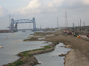
Seabrook Floodgate
Since Hurricane KatrinaHurricane Katrina
Hurricane Katrina of the 2005 Atlantic hurricane season was a powerful Atlantic hurricane. It is the costliest natural disaster, as well as one of the five deadliest hurricanes, in the history of the United States. Among recorded Atlantic hurricanes, it was the sixth strongest overall...
in 2005, proposals have been made to close the northern end of the canal by building a dam
Dam
A dam is a barrier that impounds water or underground streams. Dams generally serve the primary purpose of retaining water, while other structures such as floodgates or levees are used to manage or prevent water flow into specific land regions. Hydropower and pumped-storage hydroelectricity are...
at the entrance to Lake Pontchartrain, as part of an effort to block storm surge
Storm surge
A storm surge is an offshore rise of water associated with a low pressure weather system, typically tropical cyclones and strong extratropical cyclones. Storm surges are caused primarily by high winds pushing on the ocean's surface. The wind causes the water to pile up higher than the ordinary sea...
. A subcommittee of the Bring New Orleans Back Commission
Bring New Orleans Back Commission
The Bring New Orleans Back Commission was established by Mayor Ray Nagin of New Orleans, Louisiana, after the flooding caused by a major civil engineering failure in the aftermath of Hurricane Katrina in 2005. Aside from one Hispanic, the membership of the commission is half black and half white...
has endorsed such a move. Since a dam would prohibit shipping between the lake and the canal, the US Army Corps of Engineers has designed a surge barrier
Flood barrier
A flood barrier, surge barrier of storm surge barrier is a specific type of floodgate, designed to prevent a storm surge or spring tide from flooding the protected area behind the barrier...
, the IHNC Seabrook Floodgate Structure. Construction started in the fall of 2010, and although construction activities will continue beyond the Corps' projected June 1, 2011 deadline, a temporary cofferdam
Cofferdam
A cofferdam is a temporary enclosure built within, or in pairs across, a body of water and constructed to allow the enclosed area to be pumped out, creating a dry work environment for the major work to proceed...
has been built to reduce risk to the area during the construction.
Lake Borgne Surge Barrier
In order to prevent a future storm surge from entering the IHNC via the GIWW from Lake BorgneLake Borgne
Lake Borgne is a lagoon in eastern Louisiana of the Gulf of Mexico. Due to coastal erosion, it is no longer actually a lake but rather an arm of the Gulf of Mexico. Its name comes from the French word borgne, which means "one-eyed".-Geography:...
, the IHNC Lake Borgne Surge Barrier
IHNC Lake Borgne Surge Barrier
The Inner Harbor Navigation Canal Lake Borgne Surge Barrier is a storm surge barrier under construction near the confluence of and across the Gulf Intracoastal Waterway and the Mississippi River Gulf Outlet near New Orleans...
is under construction near the confluence of the GIWW and MRGO. This $1.1 billion project is expected to be finished in 2011. The barrier will have navigable gates in the GIWW and Bayou Bienvenue
Bayou Bienvenue
Bayou Bienvenue is a bayou in southeastern Louisiana. It runs along the political border between Orleans Parish and St. Bernard Parish to the east of New Orleans....
. These gates can be shut when a storm surge is expected.
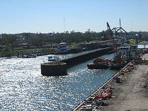
Industrial Canal Lock
Industrial Canal LockIndustrial Canal Lock
The Inner Harbor Navigation Canal Lock—commonly known as Industrial Canal Lock or simply Industrial Lock—is a navigation lock in New Orleans. It connects the Lower Mississippi River to the Industrial Canal and other sea-level waterways...
provides a connection with the Mississippi river. Because it is shorter and narrower than most modern locks on the Mississippi River System
Mississippi River System
The Mississippi River System, also referred to as the Western Rivers, is a mostly riverine network which includes the Mississippi River and connecting waterways....
, the 1920s vintage lock has become a bottleneck between the nation's two highest-tonnage waterways
Inland waterways of the United States
The inland waterways of the United States include over 25,000 miles of navigable waters. Much of the commercially important waterways of the United States consist of the Mississippi River System—the Mississippi River and connecting waterways.Almost all of the navigable rivers and canals in...
—the Mississippi and the Gulf Intracoastal Waterway
Gulf Intracoastal Waterway
The Gulf Intracoastal Waterway is the portion of the Intracoastal Waterway located along the Gulf Coast of the United States. It is a navigable inland waterway running approximately 1700 kilometers from Carrabelle, Florida, to Brownsville, Texas.The waterway provides a channel with a controlling...
.
The U.S. Army Corps of Engineers is engaged in a project to replace the canal's historic locks
Industrial Canal Lock
The Inner Harbor Navigation Canal Lock—commonly known as Industrial Canal Lock or simply Industrial Lock—is a navigation lock in New Orleans. It connects the Lower Mississippi River to the Industrial Canal and other sea-level waterways...
with larger modern locks sited to the north of Claiborne Avenue.
Maritime interests argue that in light of the closure of the MRGO, and the loss of the deepwater access it provided to the Gulf of Mexico, modern oceangoing vessels are unable to access the inner harbor of the Industrial Canal, permanently limiting the canal's utility as a site for shipyards and other industry requiring water access. Without a new lock, the port's France Road Container Terminal and Jourdan Road Wharf would also remain closed due to the inadequate deepwater access. Proponents of the new lock additionally cite dwindling barge traffic as evidence that the existing obsolete lock is choking off commerce. Opponents point to the same figures to support their contention that insufficient demand exists to justify the new lock. Neighborhood associations and environmental groups have fought the project and, on October 6, 2006, represented by the Tulane Environmental Law Clinic
Tulane Environmental Law Clinic
The Tulane Environmental Law Clinic is a legal clinic that Tulane Law School has operated since 1989 to offer law students the practical experience of representing real clients in actual legal proceedings under state and federal environmental laws....
, the Holy Cross Neighborhood Association, the Louisiana Environmental Action Network, and the Gulf Restoration Network obtained an order from the United States District Court for the Eastern District of Louisiana
United States District Court for the Eastern District of Louisiana
The U.S. District Court for the Eastern District of Louisiana is a federal trial court based in New Orleans. Like all U.S...
enjoining the project until the Corps complies with the National Environmental Policy Act
National Environmental Policy Act
The National Environmental Policy Act is a United States environmental law that established a U.S. national policy promoting the enhancement of the environment and also established the President's Council on Environmental Quality ....
.
Bridges over the canal
Bridge
A bridge is a structure built to span physical obstacles such as a body of water, valley, or road, for the purpose of providing passage over the obstacle...
s over the Industrial Canal. Each provides sufficient vertical clearance for ship
Ship
Since the end of the age of sail a ship has been any large buoyant marine vessel. Ships are generally distinguished from boats based on size and cargo or passenger capacity. Ships are used on lakes, seas, and rivers for a variety of activities, such as the transport of people or goods, fishing,...
traffic. The bridges, beginning at the north end of the canal, are:
Seabrook Bridge
Seabrook Bridge
The Seabrook Bridge is a medium-rise twin bascule, four-lane roadway bridge in New Orleans, Louisiana carrying Lakeshore Drive, connecting Leon C. Simon Drive on the upper side of the bridge with Hayne Boulevard on the lower side. The bridge is operated by the Orleans Levee District...
: Medium-rise twin bascule
Bascule bridge
A bascule bridge is a moveable bridge with a counterweight that continuously balances the span, or "leaf," throughout the entire upward swing in providing clearance for boat traffic....
, four-lane roadway bridge. The roadway is Lakeshore Drive, connecting to Leon C. Simon Drive on the upper side of the bridge, Hayne Boulevard on the lower side. The bridge is officially named Senator Ted Hickey Bridge. Operated by the Orleans Levee District. Normally stays in the down position for vehicular traffic, but provides sufficient clearance for most marine traffic.
Seabrook Railroad Bridge
Seabrook Railroad Bridge
The Seabrook Railroad Bridge is named after location near the point at which the Inner Harbor-Navigational Canal connects to Lake Pontchartrain. It is often confused with the adjacent vehicular bridge to the north, the Senator Ted Hickey Bridge...
: Bascule railroad bridge carrying two railroad tracks. Owned and operated by Port of New Orleans
Port of New Orleans
The Port of New Orleans is a port located in New Orleans, Louisiana. It is the 1st in the United States based on volume of cargo handled, second-largest in the state after the Port of South Louisiana, and 13th largest in the U.S. based on value of cargo...
. Normally stays in the up position. Amtrak
Amtrak
The National Railroad Passenger Corporation, doing business as Amtrak , is a government-owned corporation that was organized on May 1, 1971, to provide intercity passenger train service in the United States. "Amtrak" is a portmanteau of the words "America" and "track". It is headquartered at Union...
's Crescent uses this bridge. Automobile traffic used this bridge prior to the construction of the bridge above. The former automobile lanes, with their deteriorated wooden decks, still straddle the railroad span.
Danziger Bridge
Danziger Bridge
The Danziger Bridge is a vertical lift bridge which carries seven vehicular lanes of U.S. Route 90 across the Industrial Canal in New Orleans, Louisiana. It was built to replace the old Danziger Bridge, a draw bridge constructed in 1931–1932...
: Lift bridge
Lift bridge
A vertical-lift bridge or lift bridge is a type of movable bridge in which a span rises vertically while remaining parallel with the deck....
with seven vehicular lanes (US Highway 90 / Chef Menteur
Chef Menteur
Chef Menteur is associated with several place names in eastern New Orleans and South Louisiana, including:*Chef Menteur Pass*Bayou Chef Menteur*Chef Menteur Highway Chef Menteur is associated with several place names in eastern New Orleans and South Louisiana, including:*Chef Menteur Pass*Bayou...
Highway). When this bridge was completed in 1988, replacing a previous bridge of the same name, it was the widest lift bridge in the world. Most marine traffic is accommodated in the down position.
I-10 High Rise Bridge : High-rise six-lane freeway, referred to locally as "the I-10
Interstate 10
Interstate 10 is the fourth-longest Interstate Highway in the United States, after I-90, I-80, and I-40. It is the southernmost east–west, coast-to-coast Interstate Highway, although I-4 and I-8 are further south. It stretches from the Pacific Ocean at State Route 1 in Santa Monica,...
high-rise" or just "the high-rise."
Almonaster Avenue Bridge
Almonaster Avenue Bridge
The Almonaster Avenue Bridge is a bascule bridge in New Orleans, Louisiana. The bridge has two vehicular lanes of Almonaster Road and two railroad tracks over the Industrial Canal.The bridge is named after Almonaster Avenue on which it is built...
: Bascule bridge with two railroad tracks and one vehicular lane in each direction, straddling the railroad bridge. Owned and operated by Port of New Orleans. Since Hurricane Katrina
Hurricane Katrina
Hurricane Katrina of the 2005 Atlantic hurricane season was a powerful Atlantic hurricane. It is the costliest natural disaster, as well as one of the five deadliest hurricanes, in the history of the United States. Among recorded Atlantic hurricanes, it was the sixth strongest overall...
destroyed the roadways leading up to it, the bridge now normally stays in the up position.
Florida Avenue Bridge
Florida Avenue Bridge
The Florida Avenue Bridge is a vertical lift bridge spanning the Industrial Canal in New Orleans, Louisiana. The bridge has one railroad track, two vehicle lanes and two sidewalks...
: Lift bridge with one railroad track and two vehicular lanes. Owned and operated by Port of New Orleans. A parallel four-lane high-rise vehicular bridge is planned.
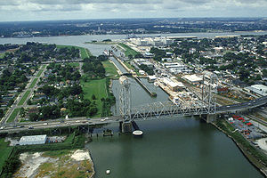
Claiborne Avenue Bridge
Claiborne Avenue Bridge
The Claiborne Avenue Bridge, officially known as the Judge William Seeber Bridge, is a vertical lift bridge in New Orleans, Louisiana over the Industrial Canal. It was built by the Louisiana Department of Highways and opened to vehicular traffic in 1957...
: Lift bridge, officially named Judge William Seeber Bridge, with four vehicular lanes (North Claiborne Avenue
Claiborne Avenue
Claiborne Avenue is a major thoroughfare in New Orleans, Louisiana. It runs the length of the city, about , beginning at the Jefferson Parish line and ending at the St. Bernard Parish line; the street continues in each of these locations under different names. It is called South Claiborne Avenue...
). Accommodates most marine traffic in the down position.
St. Claude Avenue Bridge
St. Claude Avenue Bridge
The St. Claude Avenue Bridge is a bascule bridge with four vehicular lanes over the Industrial Canal in New Orleans, Louisiana. This was originally a combination railroad and automobile bridge, with two pairs of railroad tracks in the center of the lift span and automobile lanes straddling it...
: Bascule bridge with four vehicular lanes. This was originally a combination railroad/automobile bridge, with the two pairs of railroad tracks in the center of the lift span and automobile lanes straddling it. However, the railroad is long gone, and one lane in each direction passes through the truss of the bridge and one lane passes alongside the truss. Bridge is integrated into the Industrial Lock structure, on the river side of the lock chamber. Raises when marine traffic enters or exits the lock.
See also
- Levees.Org
- Effect of Hurricane Katrina on New OrleansEffect of Hurricane Katrina on New OrleansThe effects of Hurricane Katrina in New Orleans have been long-lasting. As the center of Katrina passed South-east of New Orleans on August 29, 2005, winds downtown were in the Category 3 range with frequent intense gusts and tidal surge. Hurricane force winds were experienced throughout the...
- Mississippi River Gulf Outlet
- Gulf Intracoastal WaterwayGulf Intracoastal WaterwayThe Gulf Intracoastal Waterway is the portion of the Intracoastal Waterway located along the Gulf Coast of the United States. It is a navigable inland waterway running approximately 1700 kilometers from Carrabelle, Florida, to Brownsville, Texas.The waterway provides a channel with a controlling...
- U.S. Army Corps of Engineers civil works controversies (New Orleans)U.S. Army Corps of Engineers civil works controversies (New Orleans)Through 19 Flood Control Acts since 1917, the United States Congress has authorized the United States Army Corps of Engineers to become involved with design and construction of flood protection and damage reduction system in the Greater New Orleans area and throughout the nation.The Flood Control...