

17th Street Canal
Encyclopedia
Canal
Canals are man-made channels for water. There are two types of canal:#Waterways: navigable transportation canals used for carrying ships and boats shipping goods and conveying people, further subdivided into two kinds:...
in Greater New Orleans, Louisiana
Louisiana
Louisiana is a state located in the southern region of the United States of America. Its capital is Baton Rouge and largest city is New Orleans. Louisiana is the only state in the U.S. with political subdivisions termed parishes, which are local governments equivalent to counties...
, that flows into Lake Pontchartrain
Lake Pontchartrain
Lake Pontchartrain is a brackish estuary located in southeastern Louisiana. It is the second-largest inland saltwater body of water in the United States, after the Great Salt Lake in Utah, and the largest lake in Louisiana. As an estuary, Pontchartrain is not a true lake.It covers an area of with...
. The canal forms a significant portion of the boundary between the city of New Orleans and Metairie, Louisiana
Metairie, Louisiana
Metairie is a census-designated place in Jefferson Parish, Louisiana, United States and is a major part of the New Orleans Metropolitan Area. Metairie is the largest community in Jefferson Parish. It is an unincorporated area that would be larger than most of the state's cities if it were...
. The canal has also been known as the Metairie Outlet Canal and the Upperline Canal.
History
The canal that was to become later known as the 17th Street Canal seems to have had its origin at the start of the 1850s as a canal dug through swampy ground to raise a parallel right of way where the Jefferson and Lake Pontchartrain Railway was built. The railway, in business from 1853 through 1864, connected the town of Carrollton, LouisianaCarrollton, Louisiana
Carrollton is a neighborhood of uptown New Orleans, Louisiana, USA, which includes the Carrollton Historic District. It is the part of Uptown New Orleans farthest up river from the French Quarter...
(along the Mississippi River
Mississippi River
The Mississippi River is the largest river system in North America. Flowing entirely in the United States, this river rises in western Minnesota and meanders slowly southwards for to the Mississippi River Delta at the Gulf of Mexico. With its many tributaries, the Mississippi's watershed drains...
front) with a shipping port on Lake Pontchartrain at what became Bucktown, Louisiana, a distance of about 8 km (5 mi). At the time, most of the land between the two terminals was undeveloped swamp.
Meanwhile, in 1858, a secondary canal was built to aid in drainage in the low swampy area in "back of town" from Carrollton, with its head at what is now the intersection of Dublin and Palmetto streets, connecting to the Railway canal a short distance on the river side of the Metairie Ridge.
The railway was discontinued on 31 December 1864 as competing rail lines between the river and lake were more successful. The city of New Orleans annexed Carrollton, and the canal became the boundary line between Orleans Parish and Jefferson Parish
Jefferson Parish, Louisiana
Jefferson Parish is a parish in Louisiana, United States that includes most of the suburbs of New Orleans. The seat of parish government is Gretna....
. As the canal marked the up-river limit of Orleans Parish, it became known as the Upperline Canal.
The spur canal in the back of Carrollton was beside a projected street numbered "17th Street" (although at the time there was little actual development in back of Claiborne Avenue), and that canal was thus the first to be known as the "17th Street Canal", a name which would later come to commonly refer to the large canal which this connected to.
Improved drainage with pumping stations
Steam engine
A steam engine is a heat engine that performs mechanical work using steam as its working fluid.Steam engines are external combustion engines, where the working fluid is separate from the combustion products. Non-combustion heat sources such as solar power, nuclear power or geothermal energy may be...
powered pump known as the "Dublin Street Machine" at the back of the Carrollton neighborhood was used to drain that neighborhood, pumping the water out the Upperline Canal. Use of the canal to pump water from the streets of the city into Lake Pontchartrain grew with the city. The Claiborne Canal connected with the 17th and Upperline Canal system via a canal along Dublin Avenue; thus the canal served to carry rain water to the lake from the majority of Uptown New Orleans above the New Basin Canal
New Basin Canal
The New Basin Canal, also known as the New Orleans Canal and the New Canal, was a shipping canal in New Orleans, Louisiana from the 1830s through the 1940s....
. Another canal, Hoey's Canal, was added connecting to the Upperline from up river to help drain the back of the Jefferson Parish communities along the riverfront, now known as "Old Jefferson".
In 1894, "17th Street" was renamed "Palmetto Street" (later redesignated Palmetto Avenue), but the canal continued to be popularly known by the old street name.
In 1899 a new pumping station was opened atop the Canal a couple blocks back from Metairie Road. In the early 20th century, new high-efficiency pumps designed by A. Baldwin Wood
A. Baldwin Wood
Albert Baldwin Wood was an inventor and engineer from New Orleans, Louisiana. He graduated from Tulane University with a Bachelor of Science in Mechanical Engineering in 1899....
were installed, and remain in operation.
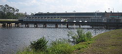
At the start of the 21st century Pumping Station 6, or the Metairie Pumping Station, astride the canal had 15 pumps capable of moving over six billion gallons of water a day through the station. Run off from substantial areas of Uptown New Orleans
Uptown New Orleans
Uptown is a section of New Orleans, Louisiana on the East Bank of the Mississippi River encompassing a number of neighborhoods between the French Quarter and the Jefferson Parish line. It remains an area of mixed residential and small commercial properties, with a wealth of 19th century architecture...
, Metairie, and surrounding neighborhoods drains into the canals and basins on the River side of the pumping station, which pulls the water up into the portion of the 17th Street Canal flowing in to Lake Pontchartrain.
20th century: Residential development of the "Back of Town"
When the Station 6 was constructed, it was at the "back" end of the developed part of town. As the area alongside the canal closer to the lake was largely undeveloped swamp, it was originally of little concern if waters pumped out of the city topped the canal and flowed into the swamp during heavy rains.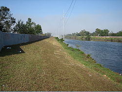
World War II
World War II, or the Second World War , was a global conflict lasting from 1939 to 1945, involving most of the world's nations—including all of the great powers—eventually forming two opposing military alliances: the Allies and the Axis...
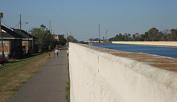
, and levees along the "back" sections of the Canal were raised. The water level of the canal is often significantly higher than the surrounding streets.
Additional smaller pumping stations were built to add drainage water to the canal from areas along its length.
After Hurricane Betsy
Hurricane Betsy
Hurricane Betsy was a Category 4 hurricane of the 1965 Atlantic hurricane season which caused enormous damage in the Bahamas, Florida, and Louisiana. Betsy made its most intense landfall near the mouth of the Mississippi River, causing significant flooding of the waters of Lake Pontchartrain into...
, improved flood protection for the city and its canals to cope with storm surge from hurricanes was mandated, resulting in increasing the size and height of the canal levees further.
In 1998 Hurricane Georges
Hurricane Georges
Hurricane Georges was a very destructive, powerful and long-lived Cape Verde-type Category 4 hurricane. Georges was the seventh tropical storm, fourth hurricane, and second major hurricane of the 1998 Atlantic hurricane season...
elevated the level of Lake Pontchartrain, pushing lake waters into the canal. A report noted that there was at least one place where the water came within inches of topping the floodwall.
An upgrade of the canal levees, floodwalls, and bridges began in 1999. The canal was considered in good shape at the start of the 2005 Atlantic Hurricane Season
2005 Atlantic hurricane season
The 2005 Atlantic hurricane season was the most active Atlantic hurricane season in recorded history, repeatedly shattering numerous records. The impact of the season was widespread and ruinous with an estimated 3,913 deaths and record damage of about $159.2 billion...
.
Hurricane Katrina
Investigations into the breach
On 10 November 2005, an article in the Times-Picayune revealed that sonar soundings discovered that the steel sheet pilings of the levee floodwall were 2.1 m (7 ft) less deep than engineering specifications. Sample pilings pulled up were found to be of the length specified in the design, but it was then revealed that this length was less than the actual depth of the canal, in retrospect an obvious engineering mistake. Current analysis strongly suggests that the catastrophic breach was due to faulty design, rather than storm and water conditions more severe than the levee and storm wall system of the canal was intended to survive.A few years before Katrina, it also became public knowledge that homes in the area near what would become the breach were experiencing problems with flooding in their yards from seepage from the canal, which they repeatedly reported. The US Army Corps of Engineers the entity responsible for the design and construction of the canal stated afterwards that they had been unaware of this. The Orleans Levee Board
Orleans Levee Board
From 1890 through 2006, the Orleans Levee Board was the body in charge of supervising the levee and floodwall system in Orleans Parish, Louisiana, which is intended to protect the city of New Orleans from flooding. The role included requirements definition prior to construction, operation, and...
which is responsible for maintenance of the canal also claimed to be unaware.
The Interagency Performance Evaluation Task Force confirmed that the canal floodwall failed at significantly lower water level than the top of the floodwall due to faulty design. In August 2007, the Corps announced the results of an engineering analysis applying more stringent post-Katrina design criteria which showed the maximum safe load on some of the surviving floodwalls is only 7 feet (2.1 m) of water, which is half the original 14 feet (4.3 m) design intent.
After Katrina
In January 2006 the U.S. Army Corps of Engineers announced it had finished the temporary repairs of the breached section of the levee, and construction of more permanent repairs would commence.The Army Corps of Engineers' district commander in New Orleans in October 2010 approved an environmental document Thursday that green lights the agency's plan to shore up faulty floodwalls and levees on the 17th Street Canal. While plans are not finalized, it is likely that a new pumping station will be constructed at the lake edge of the canal, which will serve not only to improve pumping capacity but also to act as a barrier to storm surge and lake flooding; the building would be constructed to act as an additional levee. As a temporary measure until such a new station can be built, the Corps of Engineers constructed storm surge barrier gates and an interim pump station at the lake end of the canal. Staunch critics suggested the pumps have inadequate capacity to prevent the canal from overflowing and predicted failure of both the pumps and gates. In February, 2007, a contract was awarded to WESTON Solutions to increase the pumping capacity of the 17th Street Canal. On September 1, 2008, the gates were closed as Hurricane Gustav approached the Louisiana coast. Both hydraulic and direct drive pumps were operated without problem for several hours during the peak storm surge. The gates remained closed for 18 hours and pumps were operated over a 9-hour period to keep the city from flooding.
Since repairs began, there was discussion possible about expropriation
Eminent domain
Eminent domain , compulsory purchase , resumption/compulsory acquisition , or expropriation is an action of the state to seize a citizen's private property, expropriate property, or seize a citizen's rights in property with due monetary compensation, but without the owner's consent...
of homes on either side of the canal in order to construct wider and more stable levees at crucial points along its length. On August 8, 2006, the Corps of Engineers began tearing down 14 homes on the Orleans side of the Canal.
In June, 2008, plans were announced by the Corps of Engineers
United States Army Corps of Engineers
The United States Army Corps of Engineers is a federal agency and a major Army command made up of some 38,000 civilian and military personnel, making it the world's largest public engineering, design and construction management agency...
to clear private land for access to the floodwall and levee. This land comprises the back yards along Bellaire Drive on the New Orleans (east) side of the canal. On July 7, 2008, a state court judge ruled the Corps could continue, but that property owners could seek compensation. Plans to clear encroachments on the west (Jefferson Parish) side of the canal were to begin with field surveys in early 2009.
In August 2010, the grassroots group Levees.org installed a Louisiana State Historic Plaque at the levee breach site. The text of the plaque read as follows:
See also
- Drainage in New OrleansDrainage in New OrleansDrainage in New Orleans, Louisiana has been a major concern since the founding of the city in the early 18th century, remaining an important factor in the history of New Orleans through today....
- London Avenue CanalLondon Avenue CanalThe London Avenue Canal is a drainage canal in New Orleans, Louisiana, used for pumping rain water into Lake Pontchartrain. The Canal runs through the 7th Ward of New Orleans from the Gentilly area to the Lakefront....
- Industrial CanalIndustrial CanalThe Industrial Canal is a 5.5 mile waterway in New Orleans, Louisiana, United States. The waterway's proper name, as used by the U.S. Army Corps of Engineers and on NOAA nautical charts, is Inner Harbor Navigation Canal...
- Effect of Hurricane Katrina on New OrleansEffect of Hurricane Katrina on New OrleansThe effects of Hurricane Katrina in New Orleans have been long-lasting. As the center of Katrina passed South-east of New Orleans on August 29, 2005, winds downtown were in the Category 3 range with frequent intense gusts and tidal surge. Hurricane force winds were experienced throughout the...
- U.S. Army Corps of Engineers civil works controversies (New Orleans)U.S. Army Corps of Engineers civil works controversies (New Orleans)Through 19 Flood Control Acts since 1917, the United States Congress has authorized the United States Army Corps of Engineers to become involved with design and construction of flood protection and damage reduction system in the Greater New Orleans area and throughout the nation.The Flood Control...
External links
- Levees.Org (non-profit flood protection group in New Orleans)
- Times-Picayune article "Short Sheeted" about shallow levee pilings
- Popular Mechanics article "Debunking the Myths of Hurricane Katrina" verifies that sheet piles were pulled to confirm construction according to design
- Times-Picayune photos of sheet piles being pulled to confirm construction according to design
- US Army Corps of Engineers Interim Closure Structure at 17 th St. Canal