

Northern Forest Canoe Trail
Encyclopedia
| Northern Forest Canoe Trail | |
|---|---|
| Location | Northeastern United States United States The United States of America is a federal constitutional republic comprising fifty states and a federal district... |
| Length | 740 mile (1,190 km) |
| Trailheads | Old Forge Old Forge, New York Old Forge is a hamlet on New York State Route 28 in the town of Webb in Herkimer County, New York. Old Forge was formerly a village that dissolved its incorporation, but remains the principal community in the region. Old Forge forms an extensive business district, primarily directed at tourism... , New York New York New York is a state in the Northeastern region of the United States. It is the nation's third most populous state. New York is bordered by New Jersey and Pennsylvania to the south, and by Connecticut, Massachusetts and Vermont to the east... , Fort Kent Fort Kent, Maine Fort Kent is a town in Aroostook County, Maine, United States. The population was 4,097 in the 2010 census. Fort Kent is home to an Olympic biathlete training center, an annual CAN-AM dogsled race, and the Fort Kent Blockhouse, built in reaction to the Aroostook War and in modern times designated... , Maine Maine Maine is a state in the New England region of the northeastern United States, bordered by the Atlantic Ocean to the east and south, New Hampshire to the west, and the Canadian provinces of Quebec to the northwest and New Brunswick to the northeast. Maine is both the northernmost and easternmost... |
| Use | Canoeing |
| Difficulty | Moderate to Strenuous |
| Portages | 62 (55 miles / 90 km) |
| Lakes and Ponds | 56 |
| Rivers and Streams | 22 |
| Season Season A season is a division of the year, marked by changes in weather, ecology, and hours of daylight.Seasons result from the yearly revolution of the Earth around the Sun and the tilt of the Earth's axis relative to the plane of revolution... |
Summer to Fall |
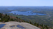
| Sights | Adirondack Mountains Adirondack Mountains The Adirondack Mountains are a mountain range located in the northeastern part of New York, that runs through Clinton, Essex, Franklin, Fulton, Hamilton, Herkimer, Lewis, Saint Lawrence, Saratoga, Warren, and Washington counties.... |
| Hazards Hazards Hazards is the only independent, union-friendly magazine to win major international awards. A recurring theme in the magazine is that workplace unions are the best hope for better, safer work - and Hazards says it provides the information and resources to make the union job easier. Hazards looks... |
Severe Weather Severe weather Severe weather phenomena are weather conditions that are hazardous to human life and property.- Examples Include :Severe weather can occur under a variety of situations, but three characteristics are generally needed: a temperature or moisture boundary, moisture, and , instability in the... Class III, IV white water |
The Northern Forest Canoe Trail (NFCT) is a 740 miles (1,190.9 km) marked canoeing
Canoeing
Canoeing is an outdoor activity that involves a special kind of canoe.Open canoes may be 'poled' , sailed, 'lined and tracked' or even 'gunnel-bobbed'....
trail in the northeastern
Northeastern United States
The Northeastern United States is a region of the United States as defined by the United States Census Bureau.-Composition:The region comprises nine states: the New England states of Connecticut, Maine, Massachusetts, New Hampshire, Rhode Island and Vermont; and the Mid-Atlantic states of New...
United States
United States
The United States of America is a federal constitutional republic comprising fifty states and a federal district...
and Canada
Canada
Canada is a North American country consisting of ten provinces and three territories. Located in the northern part of the continent, it extends from the Atlantic Ocean in the east to the Pacific Ocean in the west, and northward into the Arctic Ocean...
, extending from Old Forge
Old Forge, New York
Old Forge is a hamlet on New York State Route 28 in the town of Webb in Herkimer County, New York. Old Forge was formerly a village that dissolved its incorporation, but remains the principal community in the region. Old Forge forms an extensive business district, primarily directed at tourism...
in the Adirondacks of New York
New York
New York is a state in the Northeastern region of the United States. It is the nation's third most populous state. New York is bordered by New Jersey and Pennsylvania to the south, and by Connecticut, Massachusetts and Vermont to the east...
to Fort Kent
Fort Kent, Maine
Fort Kent is a town in Aroostook County, Maine, United States. The population was 4,097 in the 2010 census. Fort Kent is home to an Olympic biathlete training center, an annual CAN-AM dogsled race, and the Fort Kent Blockhouse, built in reaction to the Aroostook War and in modern times designated...
in Maine
Maine
Maine is a state in the New England region of the northeastern United States, bordered by the Atlantic Ocean to the east and south, New Hampshire to the west, and the Canadian provinces of Quebec to the northwest and New Brunswick to the northeast. Maine is both the northernmost and easternmost...
. Along the way, the trail also passes through the states and provinces of Vermont
Vermont
Vermont is a state in the New England region of the northeastern United States of America. The state ranks 43rd in land area, , and 45th in total area. Its population according to the 2010 census, 630,337, is the second smallest in the country, larger only than Wyoming. It is the only New England...
, Quebec
Quebec
Quebec or is a province in east-central Canada. It is the only Canadian province with a predominantly French-speaking population and the only one whose sole official language is French at the provincial level....
, and New Hampshire
New Hampshire
New Hampshire is a state in the New England region of the northeastern United States of America. The state was named after the southern English county of Hampshire. It is bordered by Massachusetts to the south, Vermont to the west, Maine and the Atlantic Ocean to the east, and the Canadian...
. The trail was opened on June 3, 2006.
The trail
The trail has been likened to a water version of the Appalachian TrailAppalachian Trail
The Appalachian National Scenic Trail, generally known as the Appalachian Trail or simply the AT, is a marked hiking trail in the eastern United States extending between Springer Mountain in Georgia and Mount Katahdin in Maine. It is approximately long...
, and there are many similarities: both are long-distance trails that most people will use for day trips or short overnight trips; many of those who paddle the entire trail will do so in sections. Unlike the AT, the NFCT obtains access for campsites and portages through landowner permission rather than through land protection. Also, many sections of the trail require a high level of skill to complete.
The trail is divided into 13 sections: Adirondack
Adirondack Mountains
The Adirondack Mountains are a mountain range located in the northeastern part of New York, that runs through Clinton, Essex, Franklin, Fulton, Hamilton, Herkimer, Lewis, Saint Lawrence, Saratoga, Warren, and Washington counties....
Country (West) New York, Adirondack North Country (Central) New York, Adirondack Country (East) New York, Islands and Farms Region Vermont, Upper Missisquoi Valley
Missisquoi River
The Missisquoi River is a tributary of Lake Champlain, approximately 80 mi long, in northern Vermont in the United States and southern Quebec in Canada. It drains a rural area of the northern Green Mountains along the US-Canada border northeast of Lake Champlain, and an area of Quebec's Eastern...
Vermont/Quebec, Northeast Kingdom
Northeast Kingdom
The Northeast Kingdom is a term used to describe the northeast corner of the U.S. state of Vermont, comprising Essex, Orleans and Caledonia Counties and having a population of 62,438. In Vermont, the written term "NEK" is often used. The term is attributed to the late George D. Aiken, former...
Quebec/Vermont, Great North Woods
Great North Woods Region (New Hampshire)
The Great North Woods Region is located at the northern tip of New Hampshire, U.S.A., north of the White Mountains Region. The Great North Woods is a tourism region of New Hampshire and is located in Coos County...
New Hampshire, Rangeley Lakes Region
Rangeley Lake
Rangeley Lake is located in Franklin County, Maine in the United States. It is fed by several streams. Its waters flow out from the lake's northwestern end into the short Rangeley River, then into Mooselookmeguntic Lake, and ultimately into the Androscoggin River, Merrymeeting Bay, the lower...
Maine, Flagstaff Region
Flagstaff Lake (Maine)
Flagstaff Lake is located in Somerset County and Franklin County, Maine in the United States. The North Branch Dead River and South Branch Dead River join in the lake, forming the Dead River....
Maine, Greater Jackman
Jackman, Maine
Jackman is a town in Somerset County, Maine, United States. The population was 718 at the 2000 census.-Geography:According to the United States Census Bureau, the town has a total area of , of which, of it is land and of it is water....
Region Maine, Moosehead
Moosehead Lake
Moosehead Lake is the largest lake in the U.S. state of Maine and the largest mountain lake in the eastern United States. Situated in the Longfellow Mountains in the Maine Highlands Region, the lake is the source of the Kennebec River. Towns that border the lake include Greenville to the south and...
/Penobscot
Penobscot River
The Penobscot River is a river in the U.S. state of Maine. Including the river's West Branch and South Branch increases the Penobscot's length to , making it the second longest river system in Maine and the longest entirely in the state. Its drainage basin contains .It arises from four branches...
Region Maine, Allagash
Allagash River
The Allagash River is a tributary of the St. John River, approximately long, in northern Maine in the United States. It drains a remote and scenic area of wilderness in the Maine North Woods north of Mount Katahdin...
Region (South) Maine, and Allagash Region (North) Maine. Each of these sections has been mapped and documented in order to establish the trail. Trail towns include Old Forge
Old Forge, New York
Old Forge is a hamlet on New York State Route 28 in the town of Webb in Herkimer County, New York. Old Forge was formerly a village that dissolved its incorporation, but remains the principal community in the region. Old Forge forms an extensive business district, primarily directed at tourism...
and Saranac Lake
Saranac Lake, New York
Saranac Lake is a village located in the state of New York, United States. As of the 2010 census, the population was 5,406. The village is named after Upper, Middle, and Lower Saranac Lakes, which are nearby....
in New York
New York
New York is a state in the Northeastern region of the United States. It is the nation's third most populous state. New York is bordered by New Jersey and Pennsylvania to the south, and by Connecticut, Massachusetts and Vermont to the east...
, and Rangeley, Maine.
The trail covers 56 lakes and ponds, 22 rivers and streams, and 62 "carries" (portage
Portage
Portage or portaging refers to the practice of carrying watercraft or cargo over land to avoid river obstacles, or between two bodies of water. A place where this carrying occurs is also called a portage; a person doing the carrying is called a porter.The English word portage is derived from the...
s) totaling 55 miles (88.5 km). On some sections of the trail, portage trails, campsites, and access areas are marked with Northern Forest Canoe Trail medallions, a yellow diamond with blue lettering.
The American Canoe Association
American Canoe Association
The American Canoe Association is the oldest and largest paddle sports organization in the United States, promoting canoeing, kayaking, and rafting. The ACA sponsors more than seven hundred events each year, along with safety education, instructor certification, waterway conservation and public...
has named the NFCT an ACA-Recommended Water Trail.
The route, by state
New York
147 miles (236.6 km). Starting at Old Forge, the route follows the Moose RiverMoose River (New York)
The Moose River is a mountain waterway which consists of three branches: the North Branch, the Middle Branch and the South Branch. The outlet of Big Moose Lake forms the North Branch in northern Herkimer County. The Middle Branch originates at the Fulton Chain Lakes in Old Forge. And the Southern...
through the Fulton Chain Lakes
Fulton Chain Lakes
The Fulton Chain Lakes are a string of eight lakes located in the Adirondack Park in upstate New York in the United States of America. These lakes are located in Herkimer County and Hamilton County...
, to Raquette Lake
Raquette Lake
Raquette Lake is the source of the Raquette River in the Adirondack Mountains of New York State, USA. It is near the community of Raquette Lake, New York. The lake has 99 miles of shoreline with pines and mountains bordering the lake. It is located in the towns of Long Lake and Arietta,...
, thence via the Raquette River
Raquette River
The Raquette River, sometimes spelled Racquette, originates at Raquette Lake in the Adirondack Mountains in New York. long, it is the third longest river entirely in the state of New York....
to Forked Lake
Forked Lake
Forked Lake is a lake in the Adirondack Park in New York, southwest of the village of Long Lake. The lake is slender, and shaped like an inverted "T", across the east-west oriented bottom but only wide, with its northward arm even narrower and long....
, Long Lake
Long Lake (New York)
Long Lake is a lake in the town of Long Lake in Hamilton County, New York in the United States; the average width is half a mile. It is part of the Raquette River, which flows in a straight, northeast-trending valley. NY 30 crosses at a narrows from the south end where the hamlet of Long Lake is...
and finally via the Stoney Creek Ponds and the Indian Carry to Upper Saranac Lake
Upper Saranac Lake
Upper Saranac Lake is one of three connected lakes, part of the Saranac River, in the towns of Santa Clara and Harrietstown, near the village of Saranac Lake in the Adirondacks in northern New York. Upper Saranac Lake is the sixth largest lake in the Adirondacks. With Middle Saranac Lake and...
. The route proceeds via Bartletts Carry to Middle Saranac Lake
Middle Saranac Lake
Middle Saranac Lake, also called Round Lake, is the smallest of three connected lakes, part of the Saranac River, near the village of Saranac Lake in the Adirondacks in northern New York. Two-thirds of its shoreline is state-owned...
, Lower Saranac Lake
Lower Saranac Lake
Lower Saranac Lake is one of three connected lakes, part of the Saranac River, near the village of Saranac Lake in the Adirondacks in northern New York. With Middle Saranac Lake and Upper Saranac Lake, a paddle with only one portage is possible. The Saranac Lake Islands Public Campground provides...
, Lake Flower
Lake Flower
Lake Flower is a lake in Franklin County and Essex County in the Adirondacks; it was created by damming the Saranac River in 1827. It was originally called Newell's Pond, but was later named for New York governor Roswell P. Flower. It is the only lake within the village of Saranac Lake. The...
, then via the Saranac River
Saranac River
Saranac River is an river in the U.S. state of New York. In its upper reaches is a region of mostly flat water and lakes. The river has more than three dozen source lakes and ponds north of Upper Saranac Lake; the highest is Mountain Pond on Long Pond Mountain...
to Franklin Falls Pond
Franklin Falls Pond
Franklin Falls Pond is a , long pond created by damming the Saranac River three miles northeast of Saranac Lake in the Adirondack Mountains of northern New York State, USA.-History:...
, Union Falls Pond, and finally Lake Champlain
Lake Champlain
Lake Champlain is a natural, freshwater lake in North America, located mainly within the borders of the United States but partially situated across the Canada—United States border in the Canadian province of Quebec.The New York portion of the Champlain Valley includes the eastern portions of...
. The route is primarily scenic flatwater, following the long-established "Highway of the Adirondacks." The Saranac River is a scenic, sometimes challenging, route off of the Adirondack Plateau.
Vermont/Quebec
174 miles (280 km). Lake ChamplainLake Champlain
Lake Champlain is a natural, freshwater lake in North America, located mainly within the borders of the United States but partially situated across the Canada—United States border in the Canadian province of Quebec.The New York portion of the Champlain Valley includes the eastern portions of...
is the most historic lake in America, and very big. The Missisquoi River
Missisquoi River
The Missisquoi River is a tributary of Lake Champlain, approximately 80 mi long, in northern Vermont in the United States and southern Quebec in Canada. It drains a rural area of the northern Green Mountains along the US-Canada border northeast of Lake Champlain, and an area of Quebec's Eastern...
is mostly slow water through a pastoral landscape, with a few rapids and several carries, including Québec’s historic "Grand Portage" to Lake Memphremagog
Lake Memphremagog
Lake Memphremagog is a fresh water glacial lake located between Newport, Vermont, United States and Magog, Quebec, Canada. The lake is long with 73 percent of the lake's surface area in Quebec, where it drains into the Magog River. However, three-quarters of its watershed, , is in Vermont. The...
. The Clyde
Clyde River (Vermont)
The Clyde River is a tributary of Lake Memphremagog, over long, in northern Vermont in the United States. It is the easternmost of the four major rivers in Orleans County. It is the most powerful of the four within Orleans County, powering several turbines at damsites...
and Nulhegan rivers each flow through sections of wetlands, ponds, and rapids, and include several carries as they flow through the Northeast Kingdom
Northeast Kingdom
The Northeast Kingdom is a term used to describe the northeast corner of the U.S. state of Vermont, comprising Essex, Orleans and Caledonia Counties and having a population of 62,438. In Vermont, the written term "NEK" is often used. The term is attributed to the late George D. Aiken, former...
of Vermont.
New Hampshire
72 miles (115.9 km). The ConnecticutConnecticut River
The Connecticut River is the largest and longest river in New England, and also an American Heritage River. It flows roughly south, starting from the Fourth Connecticut Lake in New Hampshire. After flowing through the remaining Connecticut Lakes and Lake Francis, it defines the border between the...
is placid as it meanders to the Upper Ammonoosuc
Upper Ammonoosuc River
The Upper Ammonoosuc River is a tributary of the Connecticut River that flows through Coös County in northern part of the northeastern U.S. state of New Hampshire...
. The Upper Ammonoosuc is quickwater with a few rapids. The Androscoggin
Androscoggin River
The Androscoggin River is a river in the U.S. states of Maine and New Hampshire, in northern New England. It is long and joins the Kennebec River at Merrymeeting Bay in Maine before its water empties into the Gulf of Maine on the Atlantic Ocean. Its drainage basin is in area...
flows out of Umbagog Lake, with stretches of slowly flowing water punctuated by some rapids, and a wide, quiet reservoir with relics of logging days visible on the banks.
Maine
347 miles (558.4 km). The trail starts at the Rangeley LakeRangeley Lake
Rangeley Lake is located in Franklin County, Maine in the United States. It is fed by several streams. Its waters flow out from the lake's northwestern end into the short Rangeley River, then into Mooselookmeguntic Lake, and ultimately into the Androscoggin River, Merrymeeting Bay, the lower...
s. The steep Rapid River
Rapid River (Maine)
The Rapid River is a river in the northwestern portion of the US state of Maine flowing from Lower Richardson Lake to Umbagog Lake. Despite its short length, it forms the end of a major portion of the Umbagog Lake and Androscoggin River watersheds...
is portaged. The seasonal flow of the South Branch Dead River
South Branch Dead River
The South Branch Dead River is a tributary of the Dead River in Franklin County, Maine.From the outflow of Saddleback Lake below Saddleback Mountain, the river runs northeast to Eustis, where its confluence with the North Branch of the Dead River was drowned by the impoundment of Flagstaff Lake...
has a couple of rapid sections as it flows into the wide, scenic Flagstaff Lake
Flagstaff Lake (Maine)
Flagstaff Lake is located in Somerset County and Franklin County, Maine in the United States. The North Branch Dead River and South Branch Dead River join in the lake, forming the Dead River....
. Grand Falls is a spectacular highlight at the confluence of the Dead River and Spencer Stream. The Spencer and Little Spencer watershed is remote, as is the beginning of the Moose River
Moose River (Maine)
The Moose River is an river in Maine. Its source is in Beattie , on the Canada – United States border, which runs along the height of land between the watersheds of the Kennebec River in Maine and the Chaudière River in Quebec...
. The Moose flows through many lakes and some rapids on its way to the broad, storied stretches of Moosehead Lake
Moosehead Lake
Moosehead Lake is the largest lake in the U.S. state of Maine and the largest mountain lake in the eastern United States. Situated in the Longfellow Mountains in the Maine Highlands Region, the lake is the source of the Kennebec River. Towns that border the lake include Greenville to the south and...
. The West Branch Penobscot River
West Branch Penobscot River
The West Branch Penobscot River is a tributary of Maine's Penobscot River. The river flows from Seboomook Lake in Seboomook, Somerset County; the lake's principal inflows are the North Branch and South Branch Penobscot River...
provides a connection between Moosehead and the large lakes that form the headwaters of the Allagash River
Allagash River
The Allagash River is a tributary of the St. John River, approximately long, in northern Maine in the United States. It drains a remote and scenic area of wilderness in the Maine North Woods north of Mount Katahdin...
. The Allagash Wilderness Waterway is a ribbon of lakes, ponds, rivers and occasional rapids winding through northern Maine to the wide St. John River on the Canadian border.
Through-paddlers
, 27 people have "through-paddled" the trail — traveling the length of the trail in one expedition. In addition, two others have completed it in multiple trips.Nicole Grohoski and Thomas Perkins of Ellsworth, Maine were the first to officially through-paddle the trail in 2006, traveling the length of the trail in about 45 days. Donnie Mullen paddled the trail in 2000 before its official opening, taking about 55 days but doing so without the signs and maps that are available today. The fastest thru-paddle was completed in 2007 by Alexander Bailey Martin and Benjamin Reilly; the trip took them 32 days.