

Upper Ammonoosuc River
Encyclopedia
Connecticut River
The Connecticut River is the largest and longest river in New England, and also an American Heritage River. It flows roughly south, starting from the Fourth Connecticut Lake in New Hampshire. After flowing through the remaining Connecticut Lakes and Lake Francis, it defines the border between the...
that flows through Coös County
Coos County, New Hampshire
-National protected areas:*Umbagog National Wildlife Refuge *Silvio O. Conte National Fish and Wildlife Refuge *White Mountain National Forest -Demographics:...
in northern part of the northeastern U.S. state
U.S. state
A U.S. state is any one of the 50 federated states of the United States of America that share sovereignty with the federal government. Because of this shared sovereignty, an American is a citizen both of the federal entity and of his or her state of domicile. Four states use the official title of...
of New Hampshire
New Hampshire
New Hampshire is a state in the New England region of the northeastern United States of America. The state was named after the southern English county of Hampshire. It is bordered by Massachusetts to the south, Vermont to the west, Maine and the Atlantic Ocean to the east, and the Canadian...
. Despite its name, the river is not an upstream portion of the Ammonoosuc River
Ammonoosuc River
The Ammonoosuc River is a river, 55 mi long, in northwestern New Hampshire in the United States. It is a tributary of the Connecticut River, which flows to Long Island Sound. "Ammonoosuc" is Abnaki for "small, narrow fishing place"....
, but instead a separate tributary of the Connecticut River flowing from 20 to 60 mi (32.2 to 96.6 ) to the north of the Ammonoosuc.
The Upper Ammonoosuc rises in Pond of Safety in the town of Randolph
Randolph, New Hampshire
Randolph is a heavily forested town in Coos County, New Hampshire, U.S., extending from the northern slopes of the White Mountains of the Presidential Range to Berlin , with U.S. Route 2 cutting through the middle...
, runs first generally north through rural portions of Berlin
Berlin, New Hampshire
Berlin is a city along the Androscoggin River in Coos County in northern New Hampshire, United States. The population was 10,051 at the 2010 census. It includes the village of Cascade. Located on the edge of the White Mountains, the city's boundaries extend into the White Mountain National Forest...
(where it flows through the Godfrey Dam), Milan
Milan, New Hampshire
Milan is a town in Coos County, New Hampshire, United States. The population was 1,337 at the 2010 census. It is part of the Berlin, NH–VT Micropolitan Statistical Area....
and a corner of Dummer
Dummer, New Hampshire
Dummer is a town in Coos County, New Hampshire, United States. The population was 304 at the 2010 census. It is part of the Berlin, NH–VT micropolitan statistical area...
, then west through Stark
Stark, New Hampshire
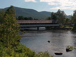
Stark is a town in Coos County, New Hampshire, United States. The population was 556 at the 2010 census. It has a famous covered bridge. The town includes the villages of Percy and Crystal as well as the village of Stark, located on the Upper Ammonoosuc River. New Hampshire Route 110 runs through...
and then Northumberland
Northumberland, New Hampshire
Northumberland is a town located in southwestern Coos County, New Hampshire, U.S., north of Lancaster. It is part of the Berlin, NH–VT micropolitan statistical area...
where it drains into the Connecticut near the village of Groveton
Groveton, New Hampshire
Groveton is a census-designated place in the town of Northumberland in Coos County, New Hampshire, United States. The population was 1,118 at the 2010 census. It is located at the intersection of U.S...
. The end points of that 42.4-mile (68.3-km) course are approximately 25 air miles (38 km) apart.
From Milan to Groveton it is fairly closely paralleled by New Hampshire Route 110
New Hampshire Route 110
New Hampshire Route 110 is a long east–west state highway in Coos County, northern New Hampshire. The road winds through the scenic, mountainous country of New Hampshire north of the White Mountain National Forest. NH 110 is locally named the Berlin-Groveton Highway.The eastern terminus of NH 110...
.
Fort Wentworth
Fort Wentworth
Fort Wentworth was built by order of Benning Wentworth in 1755. The fort was built at the junction of the Upper Ammonoosuc River and Connecticut River, in Northumberland, New Hampshire, by soldiers of Colonel Joseph Blanchard's New Hampshire Provincial Regiment including Robert Rogers. In 1759,...
was built in 1755 at the junction of the Upper Ammonoosuc and the Connecticut Rivers (now near the village of Groveton). The fort was used sporadically during both the French and Indian War
French and Indian War
The French and Indian War is the common American name for the war between Great Britain and France in North America from 1754 to 1763. In 1756, the war erupted into the world-wide conflict known as the Seven Years' War and thus came to be regarded as the North American theater of that war...
and the American Revolutionary War
American Revolutionary War
The American Revolutionary War , the American War of Independence, or simply the Revolutionary War, began as a war between the Kingdom of Great Britain and thirteen British colonies in North America, and ended in a global war between several European great powers.The war was the result of the...
.
The watershed area includes the northern Crescent Range, eastern Pliny Range and the eastern and northern Pilot Range, all in the White Mountains
White Mountains (New Hampshire)
The White Mountains are a mountain range covering about a quarter of the state of New Hampshire and a small portion of western Maine in the United States. Part of the Appalachian Mountains, they are considered the most rugged mountains in New England...
. Major tributaries of the Upper Ammonoosuc include:
- Nash StreamNash StreamNash Stream is a 15.3 mile long river in northern New Hampshire in the United States. It is a tributary of the Upper Ammonoosuc River and part of the Connecticut River watershed....
, rising in the township of OdellOdell, New HampshireOdell is a township in Coos County, New Hampshire, United States. In New Hampshire, locations, grants, townships , and purchases are unincorporated portions of a county which are not part of any town and have limited self-government...
, - Phillips BrookPhillips BrookPhillips Brook is a 19.6 mile long river in northern New Hampshire in the United States. It is a tributary of the Upper Ammonoosuc River and part of the Connecticut River watershed....
, rising in Erving's LocationErving's Location, New HampshireErving's Location is a township in Coos County, New Hampshire, United States. In New Hampshire, locations, grants, townships , and purchases are unincorporated portions of a county which are not part of any town and have limited self-government .According to the 2010 census, the population of the...
, - the North BranchNorth Branch Upper Ammonoosuc RiverThe North Branch of the Upper Ammonoosuc River is an 11.0 mile long river in northern New Hampshire in the United States. It is a tributary of the Upper Ammonoosuc River and part of the Connecticut River watershed....
of the Upper Ammonoosuc, flowing roughly parallel to and east of the main stem (with a ridge between them, that includes Hodgdon Hill and carries NH Rte. 110) in the town of MilanMilan, New HampshireMilan is a town in Coos County, New Hampshire, United States. The population was 1,337 at the 2010 census. It is part of the Berlin, NH–VT Micropolitan Statistical Area....
, to join it at West Milan, and - the West Branch of the Upper AmmonoosucWest Branch Upper Ammonoosuc RiverThe West Branch of the Upper Ammonoosuc River is a 6.1 mile long river in northern New Hampshire in the United States. It is a tributary of the Upper Ammonoosuc River and part of the Connecticut River watershed...
rising on the eastern slope of Mount CabotMount CabotMount Cabot is a mountain located in Coos County, New Hampshire. The mountain is the highest peak of the Pilot Range of the White Mountains. Cabot is flanked to the northeast by The Bulge, and to the south of Bunnell Notch by Terrace Mountain....
in KilkennyKilkenny, New HampshireKilkenny is a township located in Coos County, New Hampshire, USA. It was granted on June 4, 1774, containing about . As of the 2010 Census, the township had no inhabitants....
, draining Unknown Pond and York Pond, and joining the main stem below the Godfrey Dam.