

Norris Dam State Park
Encyclopedia
Norris Dam State Park is a state park
in Anderson County
and Campbell County, Tennessee
, in the southeastern United States. The park is situated along the shores of Norris Lake, an impoundment
of the Clinch River
created by the completion of Norris Dam
in 1936. The park consists of 4038 acres (16.3 km²) managed by the Tennessee Department of Environment and Conservation
. The park also administers the Lenoir Museum Complex, which interprets the area's aboriginal, pioneer, and early 20th-century history.
Norris Dam was the pilot project of the Tennessee Valley Authority
, a Great Depression
-era entity created by the United States government in 1933 to control flooding and bring electricity and economic development to the Tennessee Valley
. The construction and administration of the dam and reservoir would serve as a model for over two dozen other TVA dams built throughout the Tennessee Valley in subsequent decades. Along with Norris Dam State Park, there are several protected entities along Norris Lake's shores, including Big Ridge State Park
, Chuck Swan State Forest, Cove Creek Wildlife Management Area, and River Bluff Small Wild Area. Norris Dam State Park was named for Nebraska
senator George William Norris
(1861–1944), who lobbied intensively for the creation of the Tennessee Valley Authority in the early 1930s.
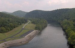 The Clinch River flows southwestward for 300 miles (482.8 km) from its source in southwestern Virginia to its mouth along the Tennessee River
near Kingston
. Norris Dam is located just over 79 miles (127.1 km) upstream from the mouth of the Clinch, near the Anderson-Campbell county line. Cove Creek, which flows down from its source in the Cumberland Mountains
roughly 25 miles (40.2 km) to the northwest, empties into the Clinch approximately 1 miles (1.6 km) north of Norris Dam. The Powell River, which also rises in southwestern Virginia, empties into the Clinch approximately 10 miles (16.1 km) upstream from Norris Dam. Norris Lake spans a 73 miles (117.5 km) stretch of the Clinch from the dam to the base of River Ridge at the Claiborne-Grainger county line. The lake also spans the lower 56 miles (90.1 km) of the Powell River from the river's mouth to a few miles south of Harrogate
, and the lower 12 miles (19.3 km) of Cove Creek.
The Norris Dam Reservation, which is managed by the Tennessee Valley Authority, consists of the area immediately around Norris Dam and immediately downstream from the dam on both sides of the Clinch. The western half of the reservation, which is largely undeveloped, is known as the River Bluff Small Wild Area. Norris Dam State Park consists of two sections along the south shore of the lake immediately east and west of the Norris Dam Reservation. The west section spans the lower 4 miles (6.4 km) of Cove Creek and includes the Andrews Ridge and West Campground section and the park offices and recreation areas. The east section spans a 5 miles (8 km) section of the Clinch between the dam and the Sequoyah Marina. The Lenoir Museum Cultural Complex— which is also part of Norris Dam State Park— consists of a small patch of land downstream from the dam on the east side of the river. Other protected areas in the vicinity include the Cove Creek Wildlife Management Area, which spans most of the lake's north shore opposite the state park, and the vast 24000 acres (97.1 km²) Chuck Swan State Forest, which covers parts of the Clinch River upstream from the park and the lower portions of the Powell River.
The Norris Freeway section of U.S. Route 441
, which crosses the dam and provides access to both sections of the park and the Lenoir Museum, connects the Norris area to Lake City
to the west and Knoxville
to the south. Interstate 75
passes roughly 5 miles (8 km) west of the park. The city of Norris
, which was developed along with the dam as part of the Norris Project in the 1930s, is located a few miles south of the dam.
 Norris Dam State Park is located entirely within the Appalachian Ridge-and-Valley Range
, which is characterized by narrow elongated ridges flanked by broad, fertile river valleys. The low rolling hills that dominate the park's terrain are underlain by sedimentary rocks— namely limestone
, dolomite
, shale
, and sandstone
— which were formed roughly 400-500 million years ago during the Paleozoic Era.
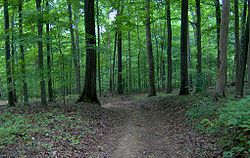
Most of Norris Dam State Park is coated by an Appalachian oak-pine forest, much of which is second-growth, although significant old growth stands remain in nearby Chuck Swan State Forest. Oak stands comprise the majority of the forest, and consist chiefly of blackjack oak
, chestnut oak
, post oak
, scarlet oak
, and red oak in drier areas and white oak
and black oak in more moist areas. The most common evergreens are the shortleaf pine
and the loblolly pine
. Less common tree species include red maple
, yellow poplar, several species of hickory
, and black gum and sweet gum. Beech
, dogwood
, and sourwood
are found in the understory.
conducted an extensive archaeological survey of the lower Clinch Valley. Webb located 23 prehistoric sites (which included 12 burial mounds and 34 townhouses) along the Clinch and its immediate watershed between what is now Oak Ridge
and Claiborne County. At Saltpeter Cave, located approximately 5 miles (8 km) above the mouth of the Powell River, Webb uncovered 13 Native American
burials as well as numerous tools and pottery fragments dating to various prehistoric periods. Webb may have been the first to differentiate between the Hiwassee Island culture (c. 1000-1300 A.D.) and the Dallas culture (c. 1300-1600 A.D.) that once dominated the Tennessee Valley (Webb noticed that one culture used "large-log" structures while the other used "small-log" structures). Webb also speculated, based on his findings in the Norris Basin, that the Cherokee
were relative newcomers in the Tennessee Valley, arriving in the area no later than the late 17th century.
 Although when the Cherokee actually arrived in the Tennessee Valley is still debated, the tribe was in control of the region when the first English explorers and traders crossed the Appalachian Mountains
into the East Tennessee area in the mid-18th century. The Clinch River Valley was explored in the 1760s by various long hunter expeditions, the most well-known of which was led by Elisha Walden in 1761. The first permanent Euro-American settlers arrived in the Anderson County and Campbell County areas in the 1790s.
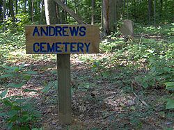
For most of the 19th and early 20th centuries, the Norris area remained sparsely populated, although several coal company towns formed in the late 19th century at the base of Cross Mountain just a few miles to the west. Of the 2,841 families removed by the Tennessee Valley Authority for the reservoir's construction in the 1930s, nearly all lived on subsistence farms
with an average size of 62.6 acres (253,333.4 m²). Several of these early inhabitants are buried in cemeteries within the state park's boundaries, namely at Andrews Cemetery atop Andrews Ridge and Harmon Cemetery near the park's headquarters.
In the 1920s, several private and public entities began lobbying the federal government for the construction of a dam at the confluence of Cove Creek and the Clinch River to control flooding in the Tennessee Valley (it had been determined that the large volume of water carried by the Clinch to the Tennessee River was partially responsible for rampant flooding in cities such as Dayton
and Chattanooga
which were downstream from this confluence). When the Tennessee Valley Authority was formed in 1933, it assumed direction of the Cove Creek Project. The project was renamed the "Norris Project" after Nebraska Senator George Norris, who had been a key advocate for the creation of the Tennessee Valley Authority in the U.S. Senate in the early 1930s. Norris Dam and its accompanying reservoir would allow control over the depths of the Tennessee River, aiding in both flood prevention and river navigation by keeping the river's depths consistent. The dam would also generate hydroelectric power, providing cheap electricity and allowing the area to modernize to a considerable extent. The city of Norris, located a few miles south of the dam, was developed as a planned city alongside the dam project. The construction of Norris Dam began on October 1, 1933 and its gates were closed on March 4, 1936.
The east section of Norris Dam State Park was developed in the 1930s by the Civilian Conservation Corps
as a "demonstration recreational project" of the Tennessee Valley Authority. The CCC built a lodge, several rustic cabins, and an amphitheater. The land was sold to the State of Tennessee in 1953. The state developed the more modern west section of the park in the 1970s, and obtained control of the marina in 1986.
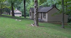 The older east section of Norris Dam State Park has 19 rustic cabins, a 40-site campground, and a convention house known as the "Tea Room". The newer west section has 10 deluxe cabins, a 50-site campground, and a recreation center. The park offices are located in the west section. The marina is located just west of the dam.
Both the east and west sections of the park have several miles of short hiking trails which meander through the forest on the ridge slopes and along the lakeshore. Several longer trails extend into the state forest to the east of the park. Hiking trails also traverse the TVA-controlled River Bluff Small Wild Area just west of the dam.
 The Lenoir Museum Cultural Complex includes the Lenoir Museum and two historical structures— the Rice Gristmill and the Crosby Threshing Barn. The Lenoir Museum mainly houses the collection of its namesakes, antique collectors Will and Helen Lenoir. After Helen died in 1960, Will donated their vast collection to the state for display. The museum includes an 1826 barrel organ
, several 19th-century room displays, an early-20th century general store counter, and various tools from the early pioneer era in East Tennessee.
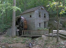
The Rice Gristmill was built by James Rice (d. 1829) in 1798. The mill originally stood on Lost Creek in what is now Union County several miles to the east (the creek is now part of an embayment along Norris Lake). The mill, which is powered by an overshot wheel-driven turbine, was refurbished and remodeled for various tasks throughout the 19th century. When the Tennessee Valley Authority purchased the Rice property along Lost Creek in 1935, the mill was in the possession of James Rice's great-grandson, Rufus Rice. The CCC and the National Park Service carefully dismantled the mill and reassembled it at its present location.
The Crosby Threshing Barn was built in the 1830s by Caleb Crosby. It was originally situated along the Holston River
near Morristown
on a farm now submerged under Cherokee Lake
. Before their farm was flooded in the 1940s, Bryant and Powell Crosby, grandsons of Caleb, donated the barn to the National Park Service. The barn was dismantled and kept in storage until 1978, when the Park Service donated it to the State of Tennessee. Along with the oxen-driven threshing machine and a mini-museum of 19th and early 20th-century farm tools, the barn houses a section of the massive Tregonia Elm, which was once believed to be the largest elm tree in the United States.
State park
State parks are parks or other protected areas managed at the federated state level within those nations which use "state" as a political subdivision. State parks are typically established by a state to preserve a location on account of its natural beauty, historic interest, or recreational...
in Anderson County
Anderson County, Tennessee
Anderson County is a U.S. county located in the U.S. state of Tennessee. As of the 2010 census, its population is 75,129. Its county seat is Clinton.It is included in the Knoxville, Tennessee, Metropolitan Statistical Area.-Geography:...
and Campbell County, Tennessee
Campbell County, Tennessee
Campbell County is a U.S. county located in the U.S. state of Tennessee. As of 2010, the population was 40,716. Its county seat is Jacksboro. The Census Bureau has identified the county as a Micropolitan Statistical Area, designated the LaFollette Micropolitan Statistical Area for the largest...
, in the southeastern United States. The park is situated along the shores of Norris Lake, an impoundment
Impoundment
Impoundment is the election of a President of the United States not to spend money that has been appropriated by the U.S. Congress. The precedent for presidential impoundment was first set by Thomas Jefferson in 1801. The power was available to all presidents up to and including Richard Nixon, and...
of the Clinch River
Clinch River
The Clinch River rises in Southwest Virginia near Tazewell, Virginia and flows southwest through the Great Appalachian Valley, gathering various tributaries including the Powell River before joining the Tennessee River in East Tennessee.-Course:...
created by the completion of Norris Dam
Norris Dam
Norris Dam is a hydroelectric and flood control structure located on the Clinch River in Anderson County and Campbell County, Tennessee, USA. Its construction in the mid-1930s was the first major project for the Tennessee Valley Authority, which had been created in 1933 to bring economic...
in 1936. The park consists of 4038 acres (16.3 km²) managed by the Tennessee Department of Environment and Conservation
Tennessee Department of Environment and Conservation
The Tennessee Department of Environment and Conservation is a Cabinet-level agency within the government of the U.S. state of Tennessee, headed by the Tennessee Commissioner of Environment and Conservation....
. The park also administers the Lenoir Museum Complex, which interprets the area's aboriginal, pioneer, and early 20th-century history.
Norris Dam was the pilot project of the Tennessee Valley Authority
Tennessee Valley Authority
The Tennessee Valley Authority is a federally owned corporation in the United States created by congressional charter in May 1933 to provide navigation, flood control, electricity generation, fertilizer manufacturing, and economic development in the Tennessee Valley, a region particularly affected...
, a Great Depression
Great Depression
The Great Depression was a severe worldwide economic depression in the decade preceding World War II. The timing of the Great Depression varied across nations, but in most countries it started in about 1929 and lasted until the late 1930s or early 1940s...
-era entity created by the United States government in 1933 to control flooding and bring electricity and economic development to the Tennessee Valley
Tennessee Valley
The Tennessee Valley is the drainage basin of the Tennessee River and is largely within the U.S. state of Tennessee. It stretches from southwest Kentucky to northwest Georgia and from northeast Mississippi to the mountains of Virginia and North Carolina...
. The construction and administration of the dam and reservoir would serve as a model for over two dozen other TVA dams built throughout the Tennessee Valley in subsequent decades. Along with Norris Dam State Park, there are several protected entities along Norris Lake's shores, including Big Ridge State Park
Big Ridge State Park
Big Ridge State Park is a state park in Union County, Tennessee, in the southeastern United States. The park consists of on the southern shore of the Norris Reservoir, an impoundment of the Clinch River created by the completion of Norris Dam in 1936...
, Chuck Swan State Forest, Cove Creek Wildlife Management Area, and River Bluff Small Wild Area. Norris Dam State Park was named for Nebraska
Nebraska
Nebraska is a state on the Great Plains of the Midwestern United States. The state's capital is Lincoln and its largest city is Omaha, on the Missouri River....
senator George William Norris
George William Norris
George William Norris was a U.S. politician from the state of Nebraska and a leader of progressive and liberal causes in Congress...
(1861–1944), who lobbied intensively for the creation of the Tennessee Valley Authority in the early 1930s.
Geographical setting
Tennessee River
The Tennessee River is the largest tributary of the Ohio River. It is approximately 652 miles long and is located in the southeastern United States in the Tennessee Valley. The river was once popularly known as the Cherokee River, among other names...
near Kingston
Kingston, Tennessee
Kingston is a city in and the county seat of Roane County, Tennessee, United States, and is adjacent to Watts Bar Lake. Kingston, with a population of 5,264 at the 2000 United States census, is included in the Harriman, Tennessee Micropolitan Statistical Area....
. Norris Dam is located just over 79 miles (127.1 km) upstream from the mouth of the Clinch, near the Anderson-Campbell county line. Cove Creek, which flows down from its source in the Cumberland Mountains
Cumberland Mountains
The Cumberland Mountains are a mountain range in the southeastern section of the Appalachian Mountains. They are located in southern West Virginia, western Virginia, eastern edges of Kentucky, and eastern middle Tennessee, including the Crab Orchard Mountains...
roughly 25 miles (40.2 km) to the northwest, empties into the Clinch approximately 1 miles (1.6 km) north of Norris Dam. The Powell River, which also rises in southwestern Virginia, empties into the Clinch approximately 10 miles (16.1 km) upstream from Norris Dam. Norris Lake spans a 73 miles (117.5 km) stretch of the Clinch from the dam to the base of River Ridge at the Claiborne-Grainger county line. The lake also spans the lower 56 miles (90.1 km) of the Powell River from the river's mouth to a few miles south of Harrogate
Harrogate, Tennessee
Harrogate is a city in Claiborne County, Tennessee, United States. The community has been known as "Harrogate" since the 19th century, but did not incorporate as a city by that name until 1993....
, and the lower 12 miles (19.3 km) of Cove Creek.
The Norris Dam Reservation, which is managed by the Tennessee Valley Authority, consists of the area immediately around Norris Dam and immediately downstream from the dam on both sides of the Clinch. The western half of the reservation, which is largely undeveloped, is known as the River Bluff Small Wild Area. Norris Dam State Park consists of two sections along the south shore of the lake immediately east and west of the Norris Dam Reservation. The west section spans the lower 4 miles (6.4 km) of Cove Creek and includes the Andrews Ridge and West Campground section and the park offices and recreation areas. The east section spans a 5 miles (8 km) section of the Clinch between the dam and the Sequoyah Marina. The Lenoir Museum Cultural Complex— which is also part of Norris Dam State Park— consists of a small patch of land downstream from the dam on the east side of the river. Other protected areas in the vicinity include the Cove Creek Wildlife Management Area, which spans most of the lake's north shore opposite the state park, and the vast 24000 acres (97.1 km²) Chuck Swan State Forest, which covers parts of the Clinch River upstream from the park and the lower portions of the Powell River.
The Norris Freeway section of U.S. Route 441
U.S. Route 441
U.S. Route 441 is a spur route of U.S. Route 41. It currently runs for 939 miles from U.S. Route 41 in Miami, Florida to U.S. Route 25W in Lake City, Tennessee. Between its termini, US 441 passes through the states of Florida, Georgia, North Carolina, and Tennessee...
, which crosses the dam and provides access to both sections of the park and the Lenoir Museum, connects the Norris area to Lake City
Lake City, Tennessee
Lake City is a town in Anderson and Campbell counties in the eastern part of the U.S. state of Tennessee, northwest of Knoxville. The population was 1,888 at the 2000 census...
to the west and Knoxville
Knoxville, Tennessee
Founded in 1786, Knoxville is the third-largest city in the U.S. state of Tennessee, U.S.A., behind Memphis and Nashville, and is the county seat of Knox County. It is the largest city in East Tennessee, and the second-largest city in the Appalachia region...
to the south. Interstate 75
Interstate 75
Interstate 75 is a major north–south Interstate Highway in the Great Lakes and Southeastern regions of the United States. It travels from State Road 826 and State Road 924 in Hialeah, Florida to Sault Ste. Marie, Michigan, at the Ontario, Canada, border...
passes roughly 5 miles (8 km) west of the park. The city of Norris
Norris, Tennessee
Norris is a city in Anderson County, Tennessee, United States. Its population was 1,446 at the 2000 census. It is included in the Knoxville, Tennessee Metropolitan Statistical Area.-History:...
, which was developed along with the dam as part of the Norris Project in the 1930s, is located a few miles south of the dam.
Natural information
Ridge-and-valley Appalachians
The Ridge-and-Valley Appalachians, also called the Ridge and Valley Province or the Valley and Ridge Appalachians, are a physiographic province of the larger Appalachian division and are also a belt within the Appalachian Mountains extending from southeastern New York through northwestern New...
, which is characterized by narrow elongated ridges flanked by broad, fertile river valleys. The low rolling hills that dominate the park's terrain are underlain by sedimentary rocks— namely limestone
Limestone
Limestone is a sedimentary rock composed largely of the minerals calcite and aragonite, which are different crystal forms of calcium carbonate . Many limestones are composed from skeletal fragments of marine organisms such as coral or foraminifera....
, dolomite
Dolomite
Dolomite is a carbonate mineral composed of calcium magnesium carbonate CaMg2. The term is also used to describe the sedimentary carbonate rock dolostone....
, shale
Shale
Shale is a fine-grained, clastic sedimentary rock composed of mud that is a mix of flakes of clay minerals and tiny fragments of other minerals, especially quartz and calcite. The ratio of clay to other minerals is variable. Shale is characterized by breaks along thin laminae or parallel layering...
, and sandstone
Sandstone
Sandstone is a sedimentary rock composed mainly of sand-sized minerals or rock grains.Most sandstone is composed of quartz and/or feldspar because these are the most common minerals in the Earth's crust. Like sand, sandstone may be any colour, but the most common colours are tan, brown, yellow,...
— which were formed roughly 400-500 million years ago during the Paleozoic Era.
Most of Norris Dam State Park is coated by an Appalachian oak-pine forest, much of which is second-growth, although significant old growth stands remain in nearby Chuck Swan State Forest. Oak stands comprise the majority of the forest, and consist chiefly of blackjack oak
Blackjack oak
Quercus marilandica is a small oak, one of the red oak group Quercus sect. Lobatae, but fairly isolated from the others...
, chestnut oak
Chestnut oak
Quercus prinus , the chestnut oak, is a species of oak in the white oak group, Quercus sect. Quercus. It is native to the eastern United States, where it is one of the most important ridgetop trees from southern Maine southwest to central Mississippi, with an outlying northwestern population in...
, post oak
Post oak
Quercus stellata is an oak in the white oak group. It is a small tree, typically 10–15 m tall and 30–60 cm trunk diameter, though occasional specimens reach 30 m tall and 140 cm diameter. It is native to the eastern United States, from Connecticut in the northeast, west to southern Iowa, southwest...
, scarlet oak
Scarlet Oak
Quercus coccinea, the scarlet oak, is an oak in the red oak section Quercus sect. Lobatae. The scarlet oak can be mistaken for the pin oak, the black oak, or occasionally the red oak. On scarlet oak the sinuses between lobes are "C"-shaped in comparison to pin oak , which has "U"-shaped sinuses...
, and red oak in drier areas and white oak
White oak
Quercus alba, the white oak, is one of the pre-eminent hardwoods of eastern North America. It is a long-lived oak of the Fagaceae family, native to eastern North America and found from southern Quebec west to eastern Minnesota and south to northern Florida and eastern Texas. Specimens have been...
and black oak in more moist areas. The most common evergreens are the shortleaf pine
Shortleaf Pine
Pinus echinata is a species of pine native to the eastern United States from southern New York south to northern Florida, west to the extreme southeast of Kansas, and southwest to eastern Texas. The tree is variable in form, sometimes straight, sometimes crooked, with an irregular crown...
and the loblolly pine
Loblolly Pine
Pinus taeda is one of several pines native to the Southeastern United States, from central Texas east to Florida, and north to Delaware. It is particularly dominant in the eastern half of North Carolina, where there are huge expanses consisting solely of Loblolly Pine trees...
. Less common tree species include red maple
Red Maple
Acer rubrum , is one of the most common and widespread deciduous trees of eastern North America. It ranges from the Lake of the Woods on the border between Ontario and Minnesota, east to Newfoundland, south to near Miami, Florida, and southwest to east Texas...
, yellow poplar, several species of hickory
Hickory
Trees in the genus Carya are commonly known as hickory, derived from the Powhatan language of Virginia. The genus includes 17–19 species of deciduous trees with pinnately compound leaves and big nuts...
, and black gum and sweet gum. Beech
Beech
Beech is a genus of ten species of deciduous trees in the family Fagaceae, native to temperate Europe, Asia and North America.-Habit:...
, dogwood
Dogwood
The genus Cornus is a group of about 30-60 species of woody plants in the family Cornaceae, commonly known as dogwoods. Most dogwoods are deciduous trees or shrubs, but a few species are nearly herbaceous perennial subshrubs, and a few of the woody species are evergreen...
, and sourwood
Sourwood
Sourwood or sorrel tree is the sole species in the genus Oxydendrum, in the family Ericaceae. It is native to eastern North America, from southern Pennsylvania south to northwest Florida and west to southern Illinois; it is most common in the lower chain of the Appalachian Mountains...
are found in the understory.
History
The Norris Basin has been inhabited on at least a semi-permanent basis since the Archaic period (c. 8000-1000 B.C.). In anticipation of the creation of the Norris Reservoir in the mid-1930s, William Webb of the Smithsonian InstitutionSmithsonian Institution
The Smithsonian Institution is an educational and research institute and associated museum complex, administered and funded by the government of the United States and by funds from its endowment, contributions, and profits from its retail operations, concessions, licensing activities, and magazines...
conducted an extensive archaeological survey of the lower Clinch Valley. Webb located 23 prehistoric sites (which included 12 burial mounds and 34 townhouses) along the Clinch and its immediate watershed between what is now Oak Ridge
Oak Ridge, Tennessee
Oak Ridge is a city in Anderson and Roane counties in the eastern part of the U.S. state of Tennessee, about west of Knoxville. Oak Ridge's population was 27,387 at the 2000 census...
and Claiborne County. At Saltpeter Cave, located approximately 5 miles (8 km) above the mouth of the Powell River, Webb uncovered 13 Native American
Native Americans in the United States
Native Americans in the United States are the indigenous peoples in North America within the boundaries of the present-day continental United States, parts of Alaska, and the island state of Hawaii. They are composed of numerous, distinct tribes, states, and ethnic groups, many of which survive as...
burials as well as numerous tools and pottery fragments dating to various prehistoric periods. Webb may have been the first to differentiate between the Hiwassee Island culture (c. 1000-1300 A.D.) and the Dallas culture (c. 1300-1600 A.D.) that once dominated the Tennessee Valley (Webb noticed that one culture used "large-log" structures while the other used "small-log" structures). Webb also speculated, based on his findings in the Norris Basin, that the Cherokee
Cherokee
The Cherokee are a Native American people historically settled in the Southeastern United States . Linguistically, they are part of the Iroquoian language family...
were relative newcomers in the Tennessee Valley, arriving in the area no later than the late 17th century.
Appalachian Mountains
The Appalachian Mountains #Whether the stressed vowel is or ,#Whether the "ch" is pronounced as a fricative or an affricate , and#Whether the final vowel is the monophthong or the diphthong .), often called the Appalachians, are a system of mountains in eastern North America. The Appalachians...
into the East Tennessee area in the mid-18th century. The Clinch River Valley was explored in the 1760s by various long hunter expeditions, the most well-known of which was led by Elisha Walden in 1761. The first permanent Euro-American settlers arrived in the Anderson County and Campbell County areas in the 1790s.
For most of the 19th and early 20th centuries, the Norris area remained sparsely populated, although several coal company towns formed in the late 19th century at the base of Cross Mountain just a few miles to the west. Of the 2,841 families removed by the Tennessee Valley Authority for the reservoir's construction in the 1930s, nearly all lived on subsistence farms
Subsistence agriculture
Subsistence agriculture is self-sufficiency farming in which the farmers focus on growing enough food to feed their families. The typical subsistence farm has a range of crops and animals needed by the family to eat and clothe themselves during the year. Planting decisions are made with an eye...
with an average size of 62.6 acres (253,333.4 m²). Several of these early inhabitants are buried in cemeteries within the state park's boundaries, namely at Andrews Cemetery atop Andrews Ridge and Harmon Cemetery near the park's headquarters.
In the 1920s, several private and public entities began lobbying the federal government for the construction of a dam at the confluence of Cove Creek and the Clinch River to control flooding in the Tennessee Valley (it had been determined that the large volume of water carried by the Clinch to the Tennessee River was partially responsible for rampant flooding in cities such as Dayton
Dayton, Tennessee
Dayton is a city in Rhea County, Tennessee, United States. The population was 6,180 at the 2000 census. The Dayton, TN, Urban Cluster, which includes developed areas adjacent to the city and extends south to Graysville, Tennessee, had 9,050 people in 2000...
and Chattanooga
Chattanooga, Tennessee
Chattanooga is the fourth-largest city in the US state of Tennessee , with a population of 169,887. It is the seat of Hamilton County...
which were downstream from this confluence). When the Tennessee Valley Authority was formed in 1933, it assumed direction of the Cove Creek Project. The project was renamed the "Norris Project" after Nebraska Senator George Norris, who had been a key advocate for the creation of the Tennessee Valley Authority in the U.S. Senate in the early 1930s. Norris Dam and its accompanying reservoir would allow control over the depths of the Tennessee River, aiding in both flood prevention and river navigation by keeping the river's depths consistent. The dam would also generate hydroelectric power, providing cheap electricity and allowing the area to modernize to a considerable extent. The city of Norris, located a few miles south of the dam, was developed as a planned city alongside the dam project. The construction of Norris Dam began on October 1, 1933 and its gates were closed on March 4, 1936.
The east section of Norris Dam State Park was developed in the 1930s by the Civilian Conservation Corps
Civilian Conservation Corps
The Civilian Conservation Corps was a public work relief program that operated from 1933 to 1942 in the United States for unemployed, unmarried men from relief families, ages 18–25. A part of the New Deal of President Franklin D...
as a "demonstration recreational project" of the Tennessee Valley Authority. The CCC built a lodge, several rustic cabins, and an amphitheater. The land was sold to the State of Tennessee in 1953. The state developed the more modern west section of the park in the 1970s, and obtained control of the marina in 1986.
The park today
Both the east and west sections of the park have several miles of short hiking trails which meander through the forest on the ridge slopes and along the lakeshore. Several longer trails extend into the state forest to the east of the park. Hiking trails also traverse the TVA-controlled River Bluff Small Wild Area just west of the dam.
Lenoir Museum Cultural Complex
Barrel organ
A barrel organ is a mechanical musical instrument consisting of bellows and one or more ranks of pipes housed in a case, usually of wood, and often highly decorated...
, several 19th-century room displays, an early-20th century general store counter, and various tools from the early pioneer era in East Tennessee.
The Rice Gristmill was built by James Rice (d. 1829) in 1798. The mill originally stood on Lost Creek in what is now Union County several miles to the east (the creek is now part of an embayment along Norris Lake). The mill, which is powered by an overshot wheel-driven turbine, was refurbished and remodeled for various tasks throughout the 19th century. When the Tennessee Valley Authority purchased the Rice property along Lost Creek in 1935, the mill was in the possession of James Rice's great-grandson, Rufus Rice. The CCC and the National Park Service carefully dismantled the mill and reassembled it at its present location.
The Crosby Threshing Barn was built in the 1830s by Caleb Crosby. It was originally situated along the Holston River
Holston River
The Holston River is a major river system of southwestern Virginia and east Tennessee. The three major forks of the Holston rise in southwestern Virginia and have their confluence near Kingsport, Tennessee. The North Fork flows southwest from Sharon Springs in Bland County, Virginia...
near Morristown
Morristown, Tennessee
Morristown is a city in, and the county seat of, Hamblen County, Tennessee, United States. The population was 29,137 at the 2010 United States Census. It is the principal city of the Morristown, Tennessee Metropolitan Statistical Area, which encompasses all of Grainger, Hamblen and Jefferson counties...
on a farm now submerged under Cherokee Lake
Cherokee Reservoir
Cherokee Reservoir, also known as Cherokee Lake, is a reservoir in Tennessee formed by the impoundment of the Holston River behind Cherokee Dam.The reservoir has a surface area of about , a flood-storage capacity of , and nearly of shoreline...
. Before their farm was flooded in the 1940s, Bryant and Powell Crosby, grandsons of Caleb, donated the barn to the National Park Service. The barn was dismantled and kept in storage until 1978, when the Park Service donated it to the State of Tennessee. Along with the oxen-driven threshing machine and a mini-museum of 19th and early 20th-century farm tools, the barn houses a section of the massive Tregonia Elm, which was once believed to be the largest elm tree in the United States.