

Routeburn Track
Encyclopedia
South Island
The South Island is the larger of the two major islands of New Zealand, the other being the more populous North Island. It is bordered to the north by Cook Strait, to the west by the Tasman Sea, to the south and east by the Pacific Ocean...
of New Zealand
New Zealand
New Zealand is an island country in the south-western Pacific Ocean comprising two main landmasses and numerous smaller islands. The country is situated some east of Australia across the Tasman Sea, and roughly south of the Pacific island nations of New Caledonia, Fiji, and Tonga...
. The track is usually completed by starting on the Queenstown
Queenstown, New Zealand
Queenstown is a resort town in Otago in the south-west of New Zealand's South Island. It is built around an inlet called Queenstown Bay on Lake Wakatipu, a long thin Z-shaped lake formed by glacial processes, and has spectacular views of nearby mountains....
side of the Southern Alps
Southern Alps
The Southern Alps is a mountain range extending along much of the length of New Zealand's South Island, reaching its greatest elevations near the island's western side...
, at the northern end of Lake Wakatipu
Lake Wakatipu
Lake Wakatipu is an inland lake in the South Island of New Zealand. It is in the southwest corner of Otago Region, near its boundary with Southland.With a length of , it is New Zealand's longest lake, and, at , its third largest...
, and finishing on the Te Anau
Te Anau
Te Anau is a town in the South Island of New Zealand. It is on the eastern shore of Lake Te Anau in Fiordland. Lake Te Anau is the largest lake in the South Island and second only within New Zealand to Lake Taupo. The 2001 census recorded the town's population as 1,857...
side, at the Divide, several kilometres from the Homer Tunnel
Homer Tunnel
The Homer Tunnel is a road tunnel in the Fiordland region of the South Island of New Zealand, opened in 1954. New Zealand State Highway 94 passes through the tunnel, linking Milford Sound to Te Anau and Queenstown, by piercing the Main Divide at the Homer Saddle...
to Milford Sound
Milford Sound
Milford Sound is a fjord in the south west of New Zealand's South Island, within Fiordland National Park, Piopiotahi Marine Reserve, and the Te Wahipounamu World Heritage site...
.
The New Zealand Department of Conservation
New Zealand Department of Conservation
The Department of Conservation , commonly known by its acronym, "DOC", is the state sector organisation which deals with the conservation of New Zealand’s natural and historic heritage...
classifies this track as a Great Walk
New Zealand Great Walks
The New Zealand Great Walks are a set of popular tramping tracks. They are New Zealand's premier tracks, through areas of some of the best scenery in the country...
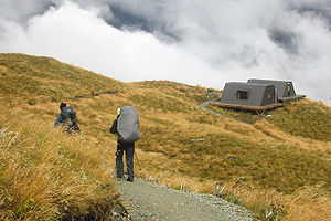
and maintains four huts along the track: Routeburn Flats Hut, Routeburn Falls Hut, Mackenzie Hut, and Howden Hut; in addition there is an emergency shelter at Harris Saddle. The track overlaps two National Parks; the Mount Aspiring National Park
Mount Aspiring National Park
Mount Aspiring National Park is located in the Southern Alps of the South Island of New Zealand, north of Fiordland National Park, and between Otago and south Westland. The park forms part of the Te Wahipounamu World Heritage site.-Geography:...
and Fiordland National Park
Fiordland National Park
Fiordland National Park occupies the southwest corner of the South Island of New Zealand. It is the largest of the 14 national parks in New Zealand, with an area of 12,500 km², and a major part of the Te Wahipounamu World Heritage site...
s with the border being Harris Saddle.
This area gets much less rain than the Milford Sound
Milford Sound
Milford Sound is a fjord in the south west of New Zealand's South Island, within Fiordland National Park, Piopiotahi Marine Reserve, and the Te Wahipounamu World Heritage site...
, and the forests are very different, especially on the eastern side of the saddle, which due to less rainfall is predominantly made up of New Zealand red beech and mountain beech, with relatively few ferns. The track spends a long time on the high ridges around Harris Saddle, with great long-distance views in many directions.
Tramping
Access to the Routeburn Track is not as tightly controlled as the Milford TrackMilford Track
The Milford Track is a widely known tramping route in New Zealand – located amidst mountains and temperate rain forest in Fiordland National Park in the southwest of the South Island....
. Camping is allowed, though both huts and camping spaces must be booked in advance during peak season. There is a surcharge for non-ticket holders. There is a choice of which direction to go, and which huts to stay in. On the western side, almost everyone stays at the Mackenzie Hut, but on the eastern side, one can stay at the Falls Hut or Flats Hut. The Falls Hut is more popular, since staying there breaks up the climb to the saddle better, especially coming from the east. Camping is not allowed at Falls Hut. In the winter, the Falls Hut is commonly used as a ski touring base for easy access into the Serpentine Range and beyond.
As it is a relatively short track, much of the Routeburn Track is also accessible to day hikers. Key Summit (918m), on the western end is the site of a popular viewpoint and nature walk not far from the roadway, and the return to the Routeburn Flats hut are both commonly done in a day.
The route
Starting at Routeburn Road end, the track crosses a swing bridge and starts as a gentle sidle up the true left hand side of the Routeburn. The well graded track crosses sugarloaf stream (start/finish of the classic five pass tramp) and the bridal veil waterfall and leads to a steeper climb that goes above the gorge to Forge Flats, the site of an early blacksmith camp. The valley opens up soon after this point, re-crosses the Routeburn and heads towards the Routeburn flats.Leaving the Routeburn Flats hut, the track climbs steadily towards the Routeburn falls Hut, passing Eagle Bluff and Emily creek, to the site of a major slip in 1987. This slip has cleared the beech forest from around the track affording views back down the Routeburn as well as up the Routeburn (north branch) towards Mt. Somnus (2293m) and Mt Momus (2148m).
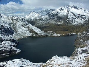
Past the Routeburn Falls hut, the track becomes narrower and more technical as it climbs past Lake Harris. Passing under bluffs as it sidles around Lake Harris there is a view up 'the valley of trolls' towards Lake Wilson (the source of the Routeburn) and the Serpentine Range.
Above Lake Harris, the track arrives at the Harris shelter. The popular side trip to Conical Hill (1515m) is commonly done from the shelter, and offers a 360 degree view of the area. From the saddle (1255m), the track traverses southwards along the Hollyford face, with expansive views out to Martins Bay and the Tasman Sea, before a descent of a steep series of zig-zags to Lake Mackenzie Hut.
From Lake Mackenzie, the track crosses a small flat before climbing to the bushline. It then gradually descends past the 'Orchard', an open grassy area dotted with ribbonwood trees, to the Earland Falls (178m high). The route passes under the falls but in times of heavy flow an alternative route exists dropping below the falls to a small bridge.
The track continues its gradual descent to down Howden Hut. From here the track branches off towards the Caples/Greenstone tracks which create a semi-circuit back towards Glenorchy, the Routeburn continuing past Key Summit to The Divide road end and the end of the track.
In popular culture
The Routeburn Track was named one of the top eleven trails in the world by the National Geographic Adventure Magazine in May 2005.No filming was done for the Lord of the Rings
The Lord of the Rings film trilogy
The Lord of the Rings is an epic film trilogy consisting of three fantasy adventure films based on the three-volume book of the same name by English author J. R. R. Tolkien. The films are The Fellowship of the Ring , The Two Towers and The Return of the King .The films were directed by Peter...
trilogy on the track itself, but the Dart River Valley
Dart River, New Zealand
The Dart River, Te Awa Wakatipu in Māori language, flows through rugged forested country in the southwestern South Island of New Zealand. Partly in Mount Aspiring National Park, it flows south-west and then south for from its headwaters in the Southern Alps and the Dart Glacier, eventually flowing...
just north of Glenorchy
Glenorchy, New Zealand
Glenorchy is a small settlement nestled in spectacular scenery at the northern end of Lake Wakatipu in New Zealand's south Island. It is approximately 45 kilometres by road or boat from Queenstown, the nearest large town....
and before the track starts, was the scene for Isengard
Isengard
In J. R. R. Tolkien's fictional universe of Middle-earth, Isengard , a translation of the Sindarin Angrenost, was a large fortress. Both names mean "Iron fortress" In J. R. R. Tolkien's fictional universe of Middle-earth, Isengard , a translation of the Sindarin Angrenost, was a large fortress....
.
There is an annual mountain run (Routeburn Classic) along the Routeburn track (approx 32–38 km) held in May each year that is completed in times of 3–9 hours depending on individual ability.
The previous two years have both been won by local athletes, Richard Ussher in 2006 and Jim Hawkridge in 2007, and both in under three hours.