
New York State Route 38
Encyclopedia
New York State Route 38 (NY 38) is a north–south state highway
in the Finger Lakes
region of New York
in the United States. Its southern terminus is at an intersection with NY 96
in the town of Owego
in Tioga County
. The northern terminus is at a junction with NY 104A
in the town of Sterling
in Cayuga County
. NY 38 is a two-lane local road for most of its length. The route is the main access road to parts of Auburn
, Dryden
, Newark Valley
and Port Byron
. It passes through mountainous terrain in Tioga and Cortland
Counties, but the terrain levels out as it heads through the Finger Lakes area and Cayuga County.
The route intersects several long-distance east–west highways, including NY 13
in Dryden, U.S. Route 20 (US 20) and NY 5
in Auburn, and NY 31
in Port Byron. It passes over the New York State Thruway
(Interstate 90 or I-90) north of Port Byron; however, there is no connection between the two. NY 38 has two suffixed routes. The first, NY 38A
is an alternate route of NY 38 between Moravia
and Auburn, while the other, NY 38B, is a simple east–west connector in the Southern Tier
. While NY 38 runs along the western shore of Owasco Lake
, NY 38A travels to Auburn along a routing east of the lake.
NY 38 passes along or near waterbodies for much of its length. From its southern end in Owego to the town of Harford
, the route parallels Owego Creek or a branch of said creek. Between Groton
and Mentz
, it runs along the aforementioned Owasco Lake and its inlet (south of the lake) and outlet (north of the lake). It also comes within 4 miles (6 km) of Lake Ontario
at its northern end.
In the 1920s, the portion of NY 38 between Owego and Freeville
was designated as New York State Route 42 while the segment from Freeville to Moravia was the southern part of New York State Route 26, a highway that continued north from Moravia to Syracuse
. NY 38 was assigned as part of the 1930 renumbering of state highways in New York, utilizing all of pre-1930 NY 42, the Freeville–Moravia portion of NY 26, and a previously unnumbered highway north to Sterling. Originally, NY 38 extended south into the Owego
by way of an overlap with NY 96. It was truncated to its current southern terminus by 1994.
—is maintained by the New York State Department of Transportation
(NYSDOT). In Auburn, the route is city-maintained to the north and south of where the route meets US 20 and NY 5 in downtown Auburn. The portion of NY 38 that runs between and overlaps with those two routes is state-maintained.
about 0.5 mile (0.80467 km) north of the Owego village
limits in the town of Owego
. The road heads northeastward as a two-lane highway, paralleling Owego Creek as it proceeds along the base of a valley surrounding the waterway. The Tioga County
portion of NY 38 passes through mostly rural, forested areas with only small, scattered pockets of development. The route continues toward the hamlet of Flemingville, where the Owego Creek splits into western and eastern branches. NY 38 does not enter the community; instead, it bypasses it to the southeast and follows the eastern branch of Owego Creek into the town of Newark Valley
.
The amount of homes along the route begins to increase as NY 38 approaches the village of Newark Valley
. Just south of the village limits, NY 38 intersects NY 38B, a spur leading to NY 26
in Maine
. The route continues into the small village as South Main Street and passes by several blocks of homes and commercial buildings. At Water Street, NY 38 becomes North Main Street; however, from this point north, most of the village is situated on the opposite bank of Owego Creek. As a result, NY 38 continues through the village limits but passes very few buildings before seamlessly exiting the community and entering another rural area.
The route continues on, crossing over Owego Creek and passing the Newark Valley Country Club about 1 miles (1.6 km) north of Newark Valley village before entering the town of Berkshire
. In Berkshire, NY 38 serves the hamlet of Berkshire, a small community situated directly on the highway. The route continues on through the narrowing creek valley into the town of Richford
and the hamlet of the same name, where it meets NY 79
in the community's center. After Richford, the valley continues to narrow for just under 1.5 miles (2.4 km) before reversing course as the route heads into Cortland County
and the town of Harford
.
NY 38 clips the extreme southwestern corner of Cortland County; as a result, only 3.38 miles (5.44 km) of the route is located within the county. Just north of the county line, the route meets NY 200 in the hamlet of Harford Mills. NY 200 is little more than an alternate route to NY 221
, which NY 38 meets in the hamlet of Harford 1.5 miles (2.4 km) to the northeast. In between Harford Mills and Harford, the east branch of Owego Creek separates from NY 38 and heads north to follow NY 221 instead. NY 38 continues northwest out of Harford hamlet and into Tompkins County
.
 Upon entering the border town of Dryden
, NY 38 emerges from the valley and becomes Dryden–Harford Road as it heads northwestward through a more low-lying but still undeveloped area. The highway gradually curves to the north toward the village of Dryden
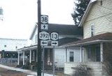
, where the route changes names to South Street upon entering the village limits. It continues north across Virgil Creek and past three blocks of homes to the commercial village center, where it intersects both NY 13
and NY 392
. The latter begins here and heads off to the east while the former joins NY 38 along North Street.
The overlap between NY 13 and NY 38 ends at the northern village line. At this point, NY 13 continues north while NY 38 forks to the west, running along the village limits on Freeville Road for about 1 miles (1.6 km) through an area with only a handful of homes. While doing so, the route passes to the south of Dryden High School
. NY 38 heads onward through an open, undeveloped area, curving to the northwest and eventually to the north as it approaches the village of Freeville
, where it serves the William George Agency for Children's Services at the southern village line. It remains on Freeville Road until Railroad Street, where it turns west and proceeds into the densely populated village center. Here, it intersects the eastern terminus of NY 366
at a junction situated adjacent to Fall Creek.
NY 38 proceeds out of Freeville, passing over Fall Creek and heading north along Groton Road through a lightly populated area of the town of Dryden. The route passes by a mixture of open fields, forests, and isolated homes on its way to the Dryden–Groton
town line, where it meets the southern terminus of NY 34B
southeast of the hamlet of Peruville. NY 38 parallels the Owasco Inlet into Groton and the village of the same name
, becoming Peru Road at the southern village line. It continues north, following South and Main Streets through the densely populated village to an intersection with NY 222
's western terminus at Cortland Street. At this point, NY 38 becomes Cayuga Street and winds its way northward along the Owasco Inlet and out of the village. Now known as Locke Road, NY 38 heads the northwest through another rural, largely undeveloped area into Cayuga County
.
region of New York, has a highly unorthodox shape. Most of the county is only about 15 miles (24 km) wide from its western border to its eastern edge. From north to south, however, it extends from Locke
north to the Lake Ontario
shoreline—a distance of about 55 miles (89 km). NY 38 passes through much of the county, ending about 4 miles (6 km) south of the shoreline in Sterling
. As a result, over half of NY 38's routing is located in the county, with the midpoint located near the city of Auburn
.
at the center of the hamlet. North of the community, the highway crosses over the Owasco Inlet and enters another rural area dominated by fields situated amongst forests. Upon crossing into the town of Moravia
, the amount of development along the highway increases as it passes Fillmore Glen State Park
and approaches the village of Moravia
.
 In Moravia, a highly developed village comprising several blocks of homes and businesses, NY 38 is known as Main Street as it heads north into the village center. At Cayuga Street, NY 38 intersects NY 38A
, the second of its two suffixed routes. NY 38A heads eastward from this point while NY 38 turns to follow West Cayuga Street across Owasco Inlet and out of the village. Past the inlet, NY 38 curves to the north and runs along the western edge of the Owasco Flats, a wide, flat-bottomed, undeveloped valley at the foot of Owasco Lake
. The flats give way to the lake in Cascade, a hamlet in the town of Venice
, at which point NY 38 begins to climb up the western edge of the lake valley. It reaches the lip of the valley 2 miles (3.2 km) later in the town of Scipio
.
For the next 2.5 miles (4 km), the route passes by open fields as it overlooks the lake to the east. The route gradually descends back into the valley as it heads further northward into the town of Fleming
. Once in Fleming, NY 38 runs along the lakeshore and serves a long line of lakeside homes as it passes by a series of fields to the west. The amount of development along the route begins to increase at the northern end of the lake in the hamlet of Melrose Park
, where NY 38 meets NY 437
by way of a traffic circle
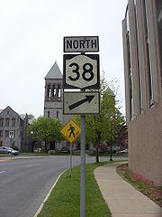
. At this point, NY 437 becomes the primary lakeside highway while NY 38 becomes a four-lane divided highway
and heads northwest as Lake Avenue toward the city of Auburn.
As NY 38 enters Auburn, it passes by Auburn High School before heading north through densely populated blocks filled with homes. The divided highway ends abruptly at Swift Street, where NY 38 turns west to follow the two-lane undivided Swift Street west for seven blocks to NY 34
(South Street). Here, NY 38 leaves Swift Street and joins NY 34 on South Street. The two routes follow South Street past the William H. Seward House
into downtown Auburn, where the homes are replaced with businesses at Lincoln Street. Three blocks later, South Street intersects with the East Arterial (eastbound US 20 and NY 5
). The overlap between NY 34 and NY 38 ends one block later at the West Arterial (westbound US 20 and NY 5), where NY 38 turns to follow the Arterial for a block to the west.
At State Street, NY 38 leaves US 20 and NY 5 and heads north through the city's north side, crossing the Owasco Outlet and serving the Auburn Correctional Facility. The route passes through several blocks of commercial and residential development up to Grant Street, where it begins to taper off. It ceases almost entirely near the northern city line at York Street, where the homes along the highway become more sporadic and spaced apart.
 Now in the town of Throop
, NY 38 follows the Owasco Outlet through open, mostly flat areas dotted with houses amongst fields and trees. Within Throop, it serves the small hamlet of Sawyers Corners, where NY 38 meets Turnpike Road (County Route 10B or CR 10B). North of this junction, the houses give way to dense forests as the route continues along the waterway into the town of Mentz
and the village of Port Byron
a short distance north of the town line. It follows Main Street through a mostly commercial and industrial portion of the village to the village center, where it intersects NY 31
at Rochester and Utica Streets. NY 38 turns west, overlapping NY 31 along Rochester Street.
The two routes cross the Owasco Outlet and enter a more residential area of the community, where NY 38 splits from NY 31 and continues north along Canal Street. The route crosses over the New York State Thruway
(I-90) as it leaves the village limits and heads north into a largely undeveloped area of forests and fields. At North Port Byron, a sparsely populated hamlet 0.5 mile (0.80467 km) north of Port Byron, NY 38 passes over the CSX Transportation
-owned Rochester Subdivision
railroad line. The highway continues on, becoming Conquest Road and crossing the Seneca River
(Erie Canal
) at Mosquito Point, near where Owasco Outlet flows into the river. NY 38 enters the town of Conquest
upon traversing the waterway.
NY 38 continues north as an unnamed highway to the hamlet of Conquest, a small community built up around the intersection of NY 38 and Fuller and Slayton Roads. It continues on into the town of Victory
, where the undeveloped fields give way to cultivated fields used as farmland. The route heads through mostly desolate surroundings to the hamlet of Victory, a slightly larger community centered on NY 38. The route proceeds through the hamlet, passing by several homes on its way to a junction with NY 370
just north of the community. Past this point, the homes cease again as NY 38 presses on through more fields and forests to the town of Sterling
.
Just north of the town line in the small hamlet of North Victory, NY 38 intersects NY 104
. Past this point, the route heads through mostly undeveloped, forested areas on its way to the hamlet of Finches Corners. North of here, the forests cede slightly as the amount of fields along the highway increases. The highway continues on to the hamlet of Sterling, where it ends at an intersection with NY 104A
(the Seaway Trail
) just south of the hamlet's center and 4 miles (6 km) south of the Lake Ontario
shoreline.
s during the 1800s. On April 13, 1819, the New York State Legislature passed a law incorporating the Cortland and Owego Turnpike Company. The company was tasked with building a highway—the Cortland and Owego Turnpike—from Owego north to the then-village of Cortland
. It roughly followed what is now NY 38 north from Owego
to the vicinity of Harford
, where it turned north to access Virgil
. It continued to Cortland by way of modern NY 215
.
On April 13, 1825, the legislature chartered the Auburn and Port Byron Turnpike Company. The Auburn and Port Byron Turnpike began at the Auburn State Prison in Auburn
and proceeded northward along the routing of NY 38 to meet the north branch of the Seneca Turnpike in the town of Brutus
(now Throop
). From there, the turnpike continued on NY 38 through Port Byron
to the Seneca River
, where it ended at a bridge crossing the river at Mosquito Point. In 1851, the Auburn and Moravia Plank Road Company was incorporated. They were tasked with connecting Moravia
to Auburn by way of a plank road along the western side of Owasco Lake
(now NY 38).
were assigned in 1924, the portion of what is now NY 38 from Freeville
to Moravia became part of NY 26, a north–south highway extending from Freeville to Syracuse
via Skaneateles
. By 1926, the segment of current NY 38 between Freeville and Owego
was designated as NY 42. In the 1930 renumbering of state highways in New York, the entirety of NY 42 and the portion of NY 26 south of Moravia was incorporated into the new NY 38, which extended north from Moravia to NY 3
(modern NY 104A
) in Sterling
. The section of the route adjacent to Owasco Lake
was still being constructed at the time of NY 38's assignment; it was completed ca. 1932.
NY 38 originally overlapped with NY 96
(designated as NY 15 in 1930) through Owego to a terminus at the modern junction of NY 96 and NY 434
south of the village. The overlap was extended slightly along Southside Drive to NY 17
exit 64 in the 1960s following the construction of the Southern Tier Expressway through the area. It was removed altogether when NY 38 was truncated to the northern end of the overlap by 1994.
State highway
State highway, state road or state route can refer to one of three related concepts, two of them related to a state or provincial government in a country that is divided into states or provinces :#A...
in the Finger Lakes
Finger Lakes
The Finger Lakes are a pattern of lakes in the west-central section of Upstate New York in the United States. They are a popular tourist destination. The lakes are long and thin , each oriented roughly on a north-south axis. The two longest, Cayuga Lake and Seneca Lake, are among the deepest in...
region of New York
New York
New York is a state in the Northeastern region of the United States. It is the nation's third most populous state. New York is bordered by New Jersey and Pennsylvania to the south, and by Connecticut, Massachusetts and Vermont to the east...
in the United States. Its southern terminus is at an intersection with NY 96
New York State Route 96
New York State Route 96 is a northwest–southeast state highway in the Finger Lakes region of New York in the United States. The southern terminus of the route is at an interchange with NY 17 in the Southern Tier village of Owego, Tioga County. Its northern terminus is at a junction with...
in the town of Owego
Owego (town), New York
Owego is a town in Tioga County, New York, USA. The population was 20,365 at the 2000 census. The name is derived from the Iroquois word Ahwaga, meaning where the valley widens....
in Tioga County
Tioga County, New York
As of the census of 2010, there were 51,125 people residing in the county, with 22,203 housing units, of these 20,350 occupied, 1,853 vacant. The population density was 98 people per square mile...
. The northern terminus is at a junction with NY 104A
New York State Route 104A
New York State Route 104A is an east–west state highway in the central portion of New York in the United States. It serves as a northerly alternate route of NY 104, to which it connects at each end...
in the town of Sterling
Sterling, New York
Sterling is a town in Cayuga County, New York, United States. The population was 3,040 at the 2010 census. The town is named after "Lord Stirling", a general of the Revolutionary War. Sterling is the most northerly town in the county...
in Cayuga County
Cayuga County, New York
Cayuga County is a county located in the U.S. state of New York. It was named for one of the tribes of Indians in the Iroquois Confederation. Its county seat is Auburn.- History :...
. NY 38 is a two-lane local road for most of its length. The route is the main access road to parts of Auburn
Auburn, New York
Auburn is a city in Cayuga County, New York, United States of America. As of the 2010 census, the city had a population of 27,687...
, Dryden
Dryden (village), New York
Dryden is a village in Tompkins County, New York, United States. The population was 1,832 at the 2000 census. The name was assigned by a clerk interested in the classics to honor John Dryden, poet and playwright....
, Newark Valley
Newark Valley (village), New York
Newark Valley is a village in Tioga County, New York, USA. The population was 1,071 at the 2000 census. It is part of the Binghamton Metropolitan Statistical Area...
and Port Byron
Port Byron, New York
Port Byron is a village in Cayuga County, New York, United States. The population was 1,297 at the 2000 census. The village is believed to be named after Lord Byron.The Village of Port Byron is in the Town of Mentz and is north of Auburn, New York....
. It passes through mountainous terrain in Tioga and Cortland
Cortland County, New York
Cortland County is a county located in the U.S. state of New York, named after Federico Van Cortlandt, president of the convention at Kingston that wrote the first New York State Constitution in 1777, and first lieutenant governor of the state. The county seat is Cortland...
Counties, but the terrain levels out as it heads through the Finger Lakes area and Cayuga County.
The route intersects several long-distance east–west highways, including NY 13
New York State Route 13
New York State Route 13 is a state highway that runs mainly north–south for between NY 14 in Horseheads and NY 3 west of Pulaski in Central New York in the United States. In between, NY 13 intersects with Interstate 81 in Cortland and Pulaski and meets the New York...
in Dryden, U.S. Route 20 (US 20) and NY 5
New York State Route 5
New York State Route 5 is a state highway that extends for across the state of New York in the United States. It begins at the Pennsylvania state line in the Chautauqua County town of Ripley and passes through Buffalo, Syracuse, Utica, Schenectady, and several other smaller cities and...
in Auburn, and NY 31
New York State Route 31
New York State Route 31 is a state highway that extends for across western and central New York in the United States. The western terminus of the route is at an intersection with NY 104 in the city of Niagara Falls. Its eastern terminus is at a traffic circle with NY 26 in Vernon...
in Port Byron. It passes over the New York State Thruway
New York State Thruway
The New York State Thruway is a system of limited-access highways located within the state of New York in the United States. The system, known officially as the Governor Thomas E. Dewey Thruway for former New York Governor Thomas E. Dewey, is operated by the New York State Thruway Authority and...
(Interstate 90 or I-90) north of Port Byron; however, there is no connection between the two. NY 38 has two suffixed routes. The first, NY 38A
New York State Route 38A
New York State Route 38A is a north–south state highway located within Onondaga and Cayuga Counties in central New York, United States. The southern terminus of the route is at an intersection with NY 38 in the village of Moravia. Its northern terminus is at a junction with U.S....
is an alternate route of NY 38 between Moravia
Moravia (village), New York
Moravia is a village in Cayuga County, New York, United States. The population was 1,363 at the 2000 census.The Village of Moravia is in the south part of the Town of Moravia and is south of Auburn, New York....
and Auburn, while the other, NY 38B, is a simple east–west connector in the Southern Tier
Southern Tier
The Southern Tier is a geographical term that refers to the counties of New York State west of the Catskill Mountains along the northern border of Pennsylvania. It is a loosely defined term that generally includes the counties that border Pennsylvania west of Delaware County inclusive...
. While NY 38 runs along the western shore of Owasco Lake
Owasco Lake
Owasco Lake is the sixth largest and third easternmost of the Finger Lakes of New York in the United States of America . The name Owasco can be roughly translated from a Mohawk and Iroquois term meaning "crossing"....
, NY 38A travels to Auburn along a routing east of the lake.
NY 38 passes along or near waterbodies for much of its length. From its southern end in Owego to the town of Harford
Harford, New York
Harford is a town in Cortland County, New York, United States. The population was 920 at the 2000 census.The Town of Harford is in the southwest part of Cortland County and is south of the City of Cortland.- History :...
, the route parallels Owego Creek or a branch of said creek. Between Groton
Groton (town), New York
Groton is a town in Tompkins County, New York, United States. The population was 5,794 at the 2000 census. The name is taken from Groton, Connecticut.The Town of Groton contains a village, also called Groton...
and Mentz
Mentz, New York
Mentz is a town in Cayuga County, New York, United States. The population was 2,378 at the 2010 census.The Town of Mentz is on the central part of the county, north of Auburn, New York.- History :...
, it runs along the aforementioned Owasco Lake and its inlet (south of the lake) and outlet (north of the lake). It also comes within 4 miles (6 km) of Lake Ontario
Lake Ontario
Lake Ontario is one of the five Great Lakes of North America. It is bounded on the north and southwest by the Canadian province of Ontario, and on the south by the American state of New York. Ontario, Canada's most populous province, was named for the lake. In the Wyandot language, ontarío means...
at its northern end.
In the 1920s, the portion of NY 38 between Owego and Freeville
Freeville, New York
Freeville is a village in Tompkins County, New York, United States. The population was 505 at the 2000 census.The Village of Freeville is in the Town of Dryden and is east of Ithaca.-History:Dryden was in the former Central New York Military Tract....
was designated as New York State Route 42 while the segment from Freeville to Moravia was the southern part of New York State Route 26, a highway that continued north from Moravia to Syracuse
Syracuse, New York
Syracuse is a city in and the county seat of Onondaga County, New York, United States, the largest U.S. city with the name "Syracuse", and the fifth most populous city in the state. At the 2010 census, the city population was 145,170, and its metropolitan area had a population of 742,603...
. NY 38 was assigned as part of the 1930 renumbering of state highways in New York, utilizing all of pre-1930 NY 42, the Freeville–Moravia portion of NY 26, and a previously unnumbered highway north to Sterling. Originally, NY 38 extended south into the Owego
Owego (village), New York
Owego is a village in and the county seat of Tioga County, New York, USA. The population was 3,911 at the 2000 census. It is part of the Binghamton Metropolitan Statistical Area...
by way of an overlap with NY 96. It was truncated to its current southern terminus by 1994.
Route description
All of NY 38—save for two sections within the city of AuburnAuburn, New York
Auburn is a city in Cayuga County, New York, United States of America. As of the 2010 census, the city had a population of 27,687...
—is maintained by the New York State Department of Transportation
New York State Department of Transportation
The New York State Department of Transportation is responsible for the development and operation of highways, railroads, mass transit systems, ports, waterways and aviation facilities in the U.S...
(NYSDOT). In Auburn, the route is city-maintained to the north and south of where the route meets US 20 and NY 5 in downtown Auburn. The portion of NY 38 that runs between and overlaps with those two routes is state-maintained.
Tioga and Cortland Counties
NY 38 begins at an intersection with NY 96New York State Route 96
New York State Route 96 is a northwest–southeast state highway in the Finger Lakes region of New York in the United States. The southern terminus of the route is at an interchange with NY 17 in the Southern Tier village of Owego, Tioga County. Its northern terminus is at a junction with...
about 0.5 mile (0.80467 km) north of the Owego village
Owego (village), New York
Owego is a village in and the county seat of Tioga County, New York, USA. The population was 3,911 at the 2000 census. It is part of the Binghamton Metropolitan Statistical Area...
limits in the town of Owego
Owego (town), New York
Owego is a town in Tioga County, New York, USA. The population was 20,365 at the 2000 census. The name is derived from the Iroquois word Ahwaga, meaning where the valley widens....
. The road heads northeastward as a two-lane highway, paralleling Owego Creek as it proceeds along the base of a valley surrounding the waterway. The Tioga County
Tioga County, New York
As of the census of 2010, there were 51,125 people residing in the county, with 22,203 housing units, of these 20,350 occupied, 1,853 vacant. The population density was 98 people per square mile...
portion of NY 38 passes through mostly rural, forested areas with only small, scattered pockets of development. The route continues toward the hamlet of Flemingville, where the Owego Creek splits into western and eastern branches. NY 38 does not enter the community; instead, it bypasses it to the southeast and follows the eastern branch of Owego Creek into the town of Newark Valley
Newark Valley (town), New York
Newark Valley is a town in Tioga County, New York, USA. The population was 4,097 at the 2000 census. The town is named after the city of Newark, New Jersey....
.
The amount of homes along the route begins to increase as NY 38 approaches the village of Newark Valley
Newark Valley (village), New York
Newark Valley is a village in Tioga County, New York, USA. The population was 1,071 at the 2000 census. It is part of the Binghamton Metropolitan Statistical Area...
. Just south of the village limits, NY 38 intersects NY 38B, a spur leading to NY 26
New York State Route 26
New York State Route 26 is a north–south state highway that runs for through Central New York in the United States. Its southern terminus is located at the Pennsylvania state line south of the town of Vestal in Broome County, where it becomes Pennsylvania Route 267...
in Maine
Maine, New York
Maine is a town in Broome County, New York, United States. The population was 5,459 at the 2000 census.The Town of Maine is on the western border of the county and is northwest of Binghamton.Maine is home to the Greater Binghamton Airport...
. The route continues into the small village as South Main Street and passes by several blocks of homes and commercial buildings. At Water Street, NY 38 becomes North Main Street; however, from this point north, most of the village is situated on the opposite bank of Owego Creek. As a result, NY 38 continues through the village limits but passes very few buildings before seamlessly exiting the community and entering another rural area.
The route continues on, crossing over Owego Creek and passing the Newark Valley Country Club about 1 miles (1.6 km) north of Newark Valley village before entering the town of Berkshire
Berkshire, New York
Berkshire is a town in Tioga County, New York, USA. As of the 2000 census, it had a population of 1,366. The town is named after Berkshire County, Massachusetts....
. In Berkshire, NY 38 serves the hamlet of Berkshire, a small community situated directly on the highway. The route continues on through the narrowing creek valley into the town of Richford
Richford, New York
Richford is a town in Tioga County, New York, United States. The population was 1,170 at the 2000 census. The town is named after Ezekial Rich, an early settler and benefactor of the town....
and the hamlet of the same name, where it meets NY 79
New York State Route 79
New York State Route 79 is an east–west state highway in the Southern Tier of New York, United States. The western terminus of the route is at the intersection with NY 414 near the southern end of Seneca Lake east of Watkins Glen...
in the community's center. After Richford, the valley continues to narrow for just under 1.5 miles (2.4 km) before reversing course as the route heads into Cortland County
Cortland County, New York
Cortland County is a county located in the U.S. state of New York, named after Federico Van Cortlandt, president of the convention at Kingston that wrote the first New York State Constitution in 1777, and first lieutenant governor of the state. The county seat is Cortland...
and the town of Harford
Harford, New York
Harford is a town in Cortland County, New York, United States. The population was 920 at the 2000 census.The Town of Harford is in the southwest part of Cortland County and is south of the City of Cortland.- History :...
.
NY 38 clips the extreme southwestern corner of Cortland County; as a result, only 3.38 miles (5.44 km) of the route is located within the county. Just north of the county line, the route meets NY 200 in the hamlet of Harford Mills. NY 200 is little more than an alternate route to NY 221
New York State Route 221
New York State Route 221 is a state highway in Cortland County, New York, United States. Its western terminus is at NY 38 in the town of Harford. The eastern terminus is at NY 26 and NY 41 in the town of Willet. Near its western end, NY 221 intersects New York State...
, which NY 38 meets in the hamlet of Harford 1.5 miles (2.4 km) to the northeast. In between Harford Mills and Harford, the east branch of Owego Creek separates from NY 38 and heads north to follow NY 221 instead. NY 38 continues northwest out of Harford hamlet and into Tompkins County
Tompkins County, New York
Tompkins County is a county located in the U.S. state of New York, and comprises the whole of the Ithaca metropolitan area. As of the 2010 census, the population was 101,564. The county seat is Ithaca, and the county is home to Cornell University, Ithaca College and Tompkins Cortland Community...
.
Tompkins County
Dryden (town), New York
Dryden is a town in Tompkins County, New York, USA. The population was 13,532 at the 2000 census. The town contains two villages: one also named Dryden and one named Freeville...
, NY 38 emerges from the valley and becomes Dryden–Harford Road as it heads northwestward through a more low-lying but still undeveloped area. The highway gradually curves to the north toward the village of Dryden
Dryden (village), New York
Dryden is a village in Tompkins County, New York, United States. The population was 1,832 at the 2000 census. The name was assigned by a clerk interested in the classics to honor John Dryden, poet and playwright....
, where the route changes names to South Street upon entering the village limits. It continues north across Virgil Creek and past three blocks of homes to the commercial village center, where it intersects both NY 13
New York State Route 13
New York State Route 13 is a state highway that runs mainly north–south for between NY 14 in Horseheads and NY 3 west of Pulaski in Central New York in the United States. In between, NY 13 intersects with Interstate 81 in Cortland and Pulaski and meets the New York...
and NY 392
New York State Route 392
New York State Route 392 is an east–west state highway in south-central New York, United States. The western terminus of the route is at an intersection with the concurrency of NY 13 and NY 38 in the village of Dryden in Tompkins County. Its eastern terminus is at a junction with U.S...
. The latter begins here and heads off to the east while the former joins NY 38 along North Street.
The overlap between NY 13 and NY 38 ends at the northern village line. At this point, NY 13 continues north while NY 38 forks to the west, running along the village limits on Freeville Road for about 1 miles (1.6 km) through an area with only a handful of homes. While doing so, the route passes to the south of Dryden High School
Dryden High School
Dryden High School is located within the Dryden Central School District. This district is in New York State's southern tier in Tompkins County, encompasses an area of and serves a population of about 1900 students. The school is at 118 Freeville Rd. in the town of Dryden, NY...
. NY 38 heads onward through an open, undeveloped area, curving to the northwest and eventually to the north as it approaches the village of Freeville
Freeville, New York
Freeville is a village in Tompkins County, New York, United States. The population was 505 at the 2000 census.The Village of Freeville is in the Town of Dryden and is east of Ithaca.-History:Dryden was in the former Central New York Military Tract....
, where it serves the William George Agency for Children's Services at the southern village line. It remains on Freeville Road until Railroad Street, where it turns west and proceeds into the densely populated village center. Here, it intersects the eastern terminus of NY 366
New York State Route 366
New York State Route 366 is an east–west state highway located entirely within Tompkins County in the Finger Lakes region of New York in the United States. It runs for from State Street just east of downtown Ithaca to NY 38 in Freeville...
at a junction situated adjacent to Fall Creek.
NY 38 proceeds out of Freeville, passing over Fall Creek and heading north along Groton Road through a lightly populated area of the town of Dryden. The route passes by a mixture of open fields, forests, and isolated homes on its way to the Dryden–Groton
Groton (town), New York
Groton is a town in Tompkins County, New York, United States. The population was 5,794 at the 2000 census. The name is taken from Groton, Connecticut.The Town of Groton contains a village, also called Groton...
town line, where it meets the southern terminus of NY 34B
New York State Route 34B
New York State Route 34B is a north–south state highway located within Tompkins and Cayuga Counties in Central New York. Its northern terminus is located at a junction with NY 34 by the hamlet of Fleming within the town of the same name in Cayuga County...
southeast of the hamlet of Peruville. NY 38 parallels the Owasco Inlet into Groton and the village of the same name
Groton (village), New York
Groton is a village in Tompkins County, New York, United States. The population was 2,470 at the 2000 census.The Village of Groton is near the center of the Town of Groton and is northeast of Ithaca and west of Cortland.- History :...
, becoming Peru Road at the southern village line. It continues north, following South and Main Streets through the densely populated village to an intersection with NY 222
New York State Route 222
New York State Route 222 is an east–west state highway in central New York, United States. It runs from NY 38 in the village of Groton in northeastern Tompkins County to the conjoined routes of U.S. Route 11, NY 13, and NY 41 in the city of Cortland in western Cortland...
's western terminus at Cortland Street. At this point, NY 38 becomes Cayuga Street and winds its way northward along the Owasco Inlet and out of the village. Now known as Locke Road, NY 38 heads the northwest through another rural, largely undeveloped area into Cayuga County
Cayuga County, New York
Cayuga County is a county located in the U.S. state of New York. It was named for one of the tribes of Indians in the Iroquois Confederation. Its county seat is Auburn.- History :...
.
Cayuga County
Cayuga County, located in the Finger LakesFinger Lakes
The Finger Lakes are a pattern of lakes in the west-central section of Upstate New York in the United States. They are a popular tourist destination. The lakes are long and thin , each oriented roughly on a north-south axis. The two longest, Cayuga Lake and Seneca Lake, are among the deepest in...
region of New York, has a highly unorthodox shape. Most of the county is only about 15 miles (24 km) wide from its western border to its eastern edge. From north to south, however, it extends from Locke
Locke, New York
Locke is a town in Cayuga County, New York, United States. The population was 1,951 at the 2010 census. The town was named after John Locke, an English philosopher and is the birthplace of Millard Fillmore, 13th President of the United States....
north to the Lake Ontario
Lake Ontario
Lake Ontario is one of the five Great Lakes of North America. It is bounded on the north and southwest by the Canadian province of Ontario, and on the south by the American state of New York. Ontario, Canada's most populous province, was named for the lake. In the Wyandot language, ontarío means...
shoreline—a distance of about 55 miles (89 km). NY 38 passes through much of the county, ending about 4 miles (6 km) south of the shoreline in Sterling
Sterling, New York
Sterling is a town in Cayuga County, New York, United States. The population was 3,040 at the 2010 census. The town is named after "Lord Stirling", a general of the Revolutionary War. Sterling is the most northerly town in the county...
. As a result, over half of NY 38's routing is located in the county, with the midpoint located near the city of Auburn
Auburn, New York
Auburn is a city in Cayuga County, New York, United States of America. As of the 2010 census, the city had a population of 27,687...
.
County line to Auburn
The route heads northwest from the county line, following the Owasco Inlet through open fields and past small patches of trees to the large hamlet of Locke. NY 38 heads north–south through the residential community as Main Street and intersects NY 90New York State Route 90
New York State Route 90 is a north–south state highway in the Finger Lakes region of New York, United States. All but five of the route's are located in Cayuga County, with the remaining situated in Cortland County. The southern terminus of the route is at an intersection with U.S....
at the center of the hamlet. North of the community, the highway crosses over the Owasco Inlet and enters another rural area dominated by fields situated amongst forests. Upon crossing into the town of Moravia
Moravia (town), New York
Moravia is a town in Cayuga County, New York, United States. The population was 3,626 at the 2010 census.The Town of Moravia contains a village called Moravia...
, the amount of development along the highway increases as it passes Fillmore Glen State Park
Fillmore Glen State Park
Fillmore Glen State Park is located adjacent to the Village of Moravia in Cayuga County, New York.The primary attractions of the park are the hiking trails with views of a stream and several waterfalls, and the swimming pond, made by damming the stream...
and approaches the village of Moravia
Moravia (village), New York
Moravia is a village in Cayuga County, New York, United States. The population was 1,363 at the 2000 census.The Village of Moravia is in the south part of the Town of Moravia and is south of Auburn, New York....
.
New York State Route 38A
New York State Route 38A is a north–south state highway located within Onondaga and Cayuga Counties in central New York, United States. The southern terminus of the route is at an intersection with NY 38 in the village of Moravia. Its northern terminus is at a junction with U.S....
, the second of its two suffixed routes. NY 38A heads eastward from this point while NY 38 turns to follow West Cayuga Street across Owasco Inlet and out of the village. Past the inlet, NY 38 curves to the north and runs along the western edge of the Owasco Flats, a wide, flat-bottomed, undeveloped valley at the foot of Owasco Lake
Owasco Lake
Owasco Lake is the sixth largest and third easternmost of the Finger Lakes of New York in the United States of America . The name Owasco can be roughly translated from a Mohawk and Iroquois term meaning "crossing"....
. The flats give way to the lake in Cascade, a hamlet in the town of Venice
Venice, New York
Venice is a town in Cayuga County, New York, United States. The population was 1,368 at the 2010 census.The Town of Venice is in the south part of Cayuga County and is south of Auburn, New York.- History :...
, at which point NY 38 begins to climb up the western edge of the lake valley. It reaches the lip of the valley 2 miles (3.2 km) later in the town of Scipio
Scipio, New York
Scipio is a town in Cayuga County, New York, United States. The population was 1,713 at the 2010 census. The town name was provided by a clerk with an interest in the classics....
.
For the next 2.5 miles (4 km), the route passes by open fields as it overlooks the lake to the east. The route gradually descends back into the valley as it heads further northward into the town of Fleming
Fleming, New York
Fleming is a town in Cayuga County, New York, United States. The population was 2,636 at the 2010 census. The name is that of General George Fleming, an early settler.The Town of Fleming is at the north end of Owasco Lake, south of Auburn, New York....
. Once in Fleming, NY 38 runs along the lakeshore and serves a long line of lakeside homes as it passes by a series of fields to the west. The amount of development along the route begins to increase at the northern end of the lake in the hamlet of Melrose Park
Melrose Park, New York
Melrose Park is a suburban community in Cayuga County, New York, United States. The population was 2,359 at the 2000 census.Melrose Park is a suburb of Auburn, New York, located south of the city.-Geography:...
, where NY 38 meets NY 437
New York State Route 437
New York State Route 437 is a state highway located south of Auburn in Cayuga County, New York, in the United States. At in length, it is the shortest signed state route in New York. It is a brief connector route between NY 38 and NY 38A known locally as White Bridge Road...
by way of a traffic circle
Traffic circle
A traffic circle or rotary is a type of circular intersection in which traffic must travel in one direction around a central island. In some countries, traffic entering the circle has the right-of-way and drivers in the circle must yield. In many other countries, traffic entering the circle must...
. At this point, NY 437 becomes the primary lakeside highway while NY 38 becomes a four-lane divided highway
Divided Highway
Divided Highway is a compilation album by American rock band The Doobie Brothers, released in 2003. . All tracks are taken from the albums Cycles and Brotherhood .-Track listing:...
and heads northwest as Lake Avenue toward the city of Auburn.
As NY 38 enters Auburn, it passes by Auburn High School before heading north through densely populated blocks filled with homes. The divided highway ends abruptly at Swift Street, where NY 38 turns west to follow the two-lane undivided Swift Street west for seven blocks to NY 34
New York State Route 34
New York State Route 34 is a north–south New York state route located in Central New York. Its southern terminus is at the Pennsylvania state line in the village of Waverly, where it connects to Pennsylvania Route 199 and meets NY 17...
(South Street). Here, NY 38 leaves Swift Street and joins NY 34 on South Street. The two routes follow South Street past the William H. Seward House
William H. Seward House
The William H. Seward House was the home of William H. Seward, who was a state senator, governor of New York, U.S. senator, presidential candidate, and then Secretary of State under presidents Abraham Lincoln and Andrew Johnson...
into downtown Auburn, where the homes are replaced with businesses at Lincoln Street. Three blocks later, South Street intersects with the East Arterial (eastbound US 20 and NY 5
New York State Route 5
New York State Route 5 is a state highway that extends for across the state of New York in the United States. It begins at the Pennsylvania state line in the Chautauqua County town of Ripley and passes through Buffalo, Syracuse, Utica, Schenectady, and several other smaller cities and...
). The overlap between NY 34 and NY 38 ends one block later at the West Arterial (westbound US 20 and NY 5), where NY 38 turns to follow the Arterial for a block to the west.
At State Street, NY 38 leaves US 20 and NY 5 and heads north through the city's north side, crossing the Owasco Outlet and serving the Auburn Correctional Facility. The route passes through several blocks of commercial and residential development up to Grant Street, where it begins to taper off. It ceases almost entirely near the northern city line at York Street, where the homes along the highway become more sporadic and spaced apart.
North of Auburn
Throop, New York
----Throop is a town in Cayuga County, New York, United States. The town is at the north city line of Auburn, New York and is in the Finger Lake District of New York. The population was 1,990 at the 2010 census. The town is named after former New York Governor Enos T...
, NY 38 follows the Owasco Outlet through open, mostly flat areas dotted with houses amongst fields and trees. Within Throop, it serves the small hamlet of Sawyers Corners, where NY 38 meets Turnpike Road (County Route 10B or CR 10B). North of this junction, the houses give way to dense forests as the route continues along the waterway into the town of Mentz
Mentz, New York
Mentz is a town in Cayuga County, New York, United States. The population was 2,378 at the 2010 census.The Town of Mentz is on the central part of the county, north of Auburn, New York.- History :...
and the village of Port Byron
Port Byron, New York
Port Byron is a village in Cayuga County, New York, United States. The population was 1,297 at the 2000 census. The village is believed to be named after Lord Byron.The Village of Port Byron is in the Town of Mentz and is north of Auburn, New York....
a short distance north of the town line. It follows Main Street through a mostly commercial and industrial portion of the village to the village center, where it intersects NY 31
New York State Route 31
New York State Route 31 is a state highway that extends for across western and central New York in the United States. The western terminus of the route is at an intersection with NY 104 in the city of Niagara Falls. Its eastern terminus is at a traffic circle with NY 26 in Vernon...
at Rochester and Utica Streets. NY 38 turns west, overlapping NY 31 along Rochester Street.
The two routes cross the Owasco Outlet and enter a more residential area of the community, where NY 38 splits from NY 31 and continues north along Canal Street. The route crosses over the New York State Thruway
New York State Thruway
The New York State Thruway is a system of limited-access highways located within the state of New York in the United States. The system, known officially as the Governor Thomas E. Dewey Thruway for former New York Governor Thomas E. Dewey, is operated by the New York State Thruway Authority and...
(I-90) as it leaves the village limits and heads north into a largely undeveloped area of forests and fields. At North Port Byron, a sparsely populated hamlet 0.5 mile (0.80467 km) north of Port Byron, NY 38 passes over the CSX Transportation
CSX Transportation
CSX Transportation operates a Class I railroad in the United States known as the CSX Railroad. It is the main subsidiary of the CSX Corporation. The company is headquartered in Jacksonville, Florida, and owns approximately 21,000 route miles...
-owned Rochester Subdivision
Rochester Subdivision
The Rochester Subdivision is a railroad line owned by CSX Transportation in the U.S. state of New York. The line runs from Syracuse west to Buffalo along the former New York Central Railroad main line. At its east end, west of downtown Syracuse, the line becomes the Mohawk Subdivision...
railroad line. The highway continues on, becoming Conquest Road and crossing the Seneca River
Seneca River (New York)
The Seneca River in central New York flows from west to east, from Seneca Lake, through the Montezuma Marsh at the north end of Cayuga Lake to the Seneca's confluence with the Oneida and Oswego rivers at the Three Rivers area north of Syracuse. Much of the river has been channelized to form part...
(Erie Canal
Erie Canal
The Erie Canal is a waterway in New York that runs about from Albany, New York, on the Hudson River to Buffalo, New York, at Lake Erie, completing a navigable water route from the Atlantic Ocean to the Great Lakes. The canal contains 36 locks and encompasses a total elevation differential of...
) at Mosquito Point, near where Owasco Outlet flows into the river. NY 38 enters the town of Conquest
Conquest, New York
Conquest is a town in Cayuga County, New York, USA. The population was 1,819 at the 2010 census. The name was chosen to mark the victory of those who wished to form the town....
upon traversing the waterway.
NY 38 continues north as an unnamed highway to the hamlet of Conquest, a small community built up around the intersection of NY 38 and Fuller and Slayton Roads. It continues on into the town of Victory
Victory, Cayuga County, New York
----Victory is a town in Cayuga County, New York, United States. The population was 1,660 at the 2010 census. The name celebrates the political victory in forming the town....
, where the undeveloped fields give way to cultivated fields used as farmland. The route heads through mostly desolate surroundings to the hamlet of Victory, a slightly larger community centered on NY 38. The route proceeds through the hamlet, passing by several homes on its way to a junction with NY 370
New York State Route 370
New York State Route 370 is an east–west state highway in central New York in the United States. It extends for from an intersection with NY 104 and NY 104A south of the Wayne County village of Red Creek to a junction with U.S. Route 11 in the Onondaga County city of Syracuse...
just north of the community. Past this point, the homes cease again as NY 38 presses on through more fields and forests to the town of Sterling
Sterling, New York
Sterling is a town in Cayuga County, New York, United States. The population was 3,040 at the 2010 census. The town is named after "Lord Stirling", a general of the Revolutionary War. Sterling is the most northerly town in the county...
.
Just north of the town line in the small hamlet of North Victory, NY 38 intersects NY 104
New York State Route 104
New York State Route 104 is a long east–west state highway in Upstate New York, United States. It spans six counties and enters the vicinity of four cities—Niagara Falls, Lockport, Rochester, and Oswego—as it follows a routing largely parallel to that of the southern shoreline of Lake...
. Past this point, the route heads through mostly undeveloped, forested areas on its way to the hamlet of Finches Corners. North of here, the forests cede slightly as the amount of fields along the highway increases. The highway continues on to the hamlet of Sterling, where it ends at an intersection with NY 104A
New York State Route 104A
New York State Route 104A is an east–west state highway in the central portion of New York in the United States. It serves as a northerly alternate route of NY 104, to which it connects at each end...
(the Seaway Trail
Seaway Trail
The Great Lakes Seaway Trail, formerly named and commonly known as the Seaway Trail, is a National Scenic Byway in the northeastern United States, mostly contained in New York but with a small segment in Pennsylvania...
) just south of the hamlet's center and 4 miles (6 km) south of the Lake Ontario
Lake Ontario
Lake Ontario is one of the five Great Lakes of North America. It is bounded on the north and southwest by the Canadian province of Ontario, and on the south by the American state of New York. Ontario, Canada's most populous province, was named for the lake. In the Wyandot language, ontarío means...
shoreline.
Old roads
Several portions of modern NY 38 were originally part of turnpikes and plank roadPlank road
A plank road or puncheon is a dirt path or road covered with a series of planks, similar to the wooden sidewalks one would see in a Western movie. Plank roads were very popular in Ontario, the U.S. Northeast and U.S. Midwest in the first half of the 19th century...
s during the 1800s. On April 13, 1819, the New York State Legislature passed a law incorporating the Cortland and Owego Turnpike Company. The company was tasked with building a highway—the Cortland and Owego Turnpike—from Owego north to the then-village of Cortland
Cortland, New York
Cortland is a city in Cortland County, New York, USA. As of the 2000 census, the city had a population of 18,740. It is the county seat of Cortland County.The City of Cortland, near the west border of the county, is surrounded by the Town of Cortlandville....
. It roughly followed what is now NY 38 north from Owego
Owego (village), New York
Owego is a village in and the county seat of Tioga County, New York, USA. The population was 3,911 at the 2000 census. It is part of the Binghamton Metropolitan Statistical Area...
to the vicinity of Harford
Harford, New York
Harford is a town in Cortland County, New York, United States. The population was 920 at the 2000 census.The Town of Harford is in the southwest part of Cortland County and is south of the City of Cortland.- History :...
, where it turned north to access Virgil
Virgil, New York
Virgil is a town in Cortland County, New York, United States. The population was 2,287 at the 2000 census. The name is from the Roman poet Virgil...
. It continued to Cortland by way of modern NY 215
New York State Route 215
New York State Route 215 is a north–south state highway located entirely within Cortland County, New York, in the United States. It extends for just over from an intersection with NY 392 in the town of Virgil to a junction with NY 13 in the city of Cortland...
.
On April 13, 1825, the legislature chartered the Auburn and Port Byron Turnpike Company. The Auburn and Port Byron Turnpike began at the Auburn State Prison in Auburn
Auburn, New York
Auburn is a city in Cayuga County, New York, United States of America. As of the 2010 census, the city had a population of 27,687...
and proceeded northward along the routing of NY 38 to meet the north branch of the Seneca Turnpike in the town of Brutus
Brutus, New York
Brutus is a town in Cayuga County, New York, USA. The population was 4,464 at the 2010 census. The name was assigned by a clerk interested in the classics.The Town of Brutus is located in the east part of the county and is west of Syracuse....
(now Throop
Throop, New York
----Throop is a town in Cayuga County, New York, United States. The town is at the north city line of Auburn, New York and is in the Finger Lake District of New York. The population was 1,990 at the 2010 census. The town is named after former New York Governor Enos T...
). From there, the turnpike continued on NY 38 through Port Byron
Port Byron, New York
Port Byron is a village in Cayuga County, New York, United States. The population was 1,297 at the 2000 census. The village is believed to be named after Lord Byron.The Village of Port Byron is in the Town of Mentz and is north of Auburn, New York....
to the Seneca River
Seneca River (New York)
The Seneca River in central New York flows from west to east, from Seneca Lake, through the Montezuma Marsh at the north end of Cayuga Lake to the Seneca's confluence with the Oneida and Oswego rivers at the Three Rivers area north of Syracuse. Much of the river has been channelized to form part...
, where it ended at a bridge crossing the river at Mosquito Point. In 1851, the Auburn and Moravia Plank Road Company was incorporated. They were tasked with connecting Moravia
Moravia (village), New York
Moravia is a village in Cayuga County, New York, United States. The population was 1,363 at the 2000 census.The Village of Moravia is in the south part of the Town of Moravia and is south of Auburn, New York....
to Auburn by way of a plank road along the western side of Owasco Lake
Owasco Lake
Owasco Lake is the sixth largest and third easternmost of the Finger Lakes of New York in the United States of America . The name Owasco can be roughly translated from a Mohawk and Iroquois term meaning "crossing"....
(now NY 38).
Designation
When the first set of posted routes in New YorkNew York
New York is a state in the Northeastern region of the United States. It is the nation's third most populous state. New York is bordered by New Jersey and Pennsylvania to the south, and by Connecticut, Massachusetts and Vermont to the east...
were assigned in 1924, the portion of what is now NY 38 from Freeville
Freeville, New York
Freeville is a village in Tompkins County, New York, United States. The population was 505 at the 2000 census.The Village of Freeville is in the Town of Dryden and is east of Ithaca.-History:Dryden was in the former Central New York Military Tract....
to Moravia became part of NY 26, a north–south highway extending from Freeville to Syracuse
Syracuse, New York
Syracuse is a city in and the county seat of Onondaga County, New York, United States, the largest U.S. city with the name "Syracuse", and the fifth most populous city in the state. At the 2010 census, the city population was 145,170, and its metropolitan area had a population of 742,603...
via Skaneateles
Skaneateles (village), New York
Skaneateles is a village in the town of Skaneateles, Onondaga County, New York, United States. The village is named from and located on the shores of Skaneateles Lake, one of the Finger Lakes. The village, as of the 2000 census, has a population of 2,616 residents. The main highway through the...
. By 1926, the segment of current NY 38 between Freeville and Owego
Owego (village), New York
Owego is a village in and the county seat of Tioga County, New York, USA. The population was 3,911 at the 2000 census. It is part of the Binghamton Metropolitan Statistical Area...
was designated as NY 42. In the 1930 renumbering of state highways in New York, the entirety of NY 42 and the portion of NY 26 south of Moravia was incorporated into the new NY 38, which extended north from Moravia to NY 3
New York State Route 3
New York State Route 3 is a major east–west state highway in New York, United States, that connects central New York to the North Country region near the Canadian border via Adirondack Park. The route extends for between its western terminus at an intersection with NY 104A in the Cayuga...
(modern NY 104A
New York State Route 104A
New York State Route 104A is an east–west state highway in the central portion of New York in the United States. It serves as a northerly alternate route of NY 104, to which it connects at each end...
) in Sterling
Sterling, New York
Sterling is a town in Cayuga County, New York, United States. The population was 3,040 at the 2010 census. The town is named after "Lord Stirling", a general of the Revolutionary War. Sterling is the most northerly town in the county...
. The section of the route adjacent to Owasco Lake
Owasco Lake
Owasco Lake is the sixth largest and third easternmost of the Finger Lakes of New York in the United States of America . The name Owasco can be roughly translated from a Mohawk and Iroquois term meaning "crossing"....
was still being constructed at the time of NY 38's assignment; it was completed ca. 1932.
NY 38 originally overlapped with NY 96
New York State Route 96
New York State Route 96 is a northwest–southeast state highway in the Finger Lakes region of New York in the United States. The southern terminus of the route is at an interchange with NY 17 in the Southern Tier village of Owego, Tioga County. Its northern terminus is at a junction with...
(designated as NY 15 in 1930) through Owego to a terminus at the modern junction of NY 96 and NY 434
New York State Route 434
New York State Route 434 is a state highway located in the Southern Tier of the U.S. state of New York. The route extends for from an intersection with NY 96 in the village of Owego to an intersection with US 11 in the city of Binghamton. In between, NY 434 passes through the...
south of the village. The overlap was extended slightly along Southside Drive to NY 17
New York State Route 17
New York State Route 17 is a state highway that extends for through the Southern Tier and Downstate regions of New York in the United States...
exit 64 in the 1960s following the construction of the Southern Tier Expressway through the area. It was removed altogether when NY 38 was truncated to the northern end of the overlap by 1994.
Suffixed routes
- NY 38ANew York State Route 38ANew York State Route 38A is a north–south state highway located within Onondaga and Cayuga Counties in central New York, United States. The southern terminus of the route is at an intersection with NY 38 in the village of Moravia. Its northern terminus is at a junction with U.S....
(21.91 miles or 35.26 km) runs from Moravia to NY 359New York State Route 359New York State Route 359 is a state highway located entirely within the town of Skaneateles in Onondaga County, New York in the United States. At in length, it is one of the shortest signed state highways in all of New York...
, near Mandana and NY 41ANew York State Route 41ANew York State Route 41A is a north–south New York State Route located within Onondaga, Cayuga, and Cortland Counties in Central New York. Its northern terminus is located at a junction with U.S. Route 20 in the village of Skaneateles in Onondaga County...
in southwestern Onondaga County, and then towards Auburn. It was assigned as part of the 1930 renumbering of state highways in New York. - NY 38B (7.69 miles or 12.38 km) is a short spur in BroomeBroome County, New YorkBroome County is a county located in the U.S. state of New York. As of the 2010 census, the population was 200,600. It was named in honor of John Broome, who was lieutenant governor in 1806 when Broome County was established. Its county seat is Binghamton, which is also its major city. The current...
and TiogaTioga County, New YorkAs of the census of 2010, there were 51,125 people residing in the county, with 22,203 housing units, of these 20,350 occupied, 1,853 vacant. The population density was 98 people per square mile...
Counties connecting NY 38 in Newark ValleyNewark Valley (village), New YorkNewark Valley is a village in Tioga County, New York, USA. The population was 1,071 at the 2000 census. It is part of the Binghamton Metropolitan Statistical Area...
in the west to NY 26New York State Route 26New York State Route 26 is a north–south state highway that runs for through Central New York in the United States. Its southern terminus is located at the Pennsylvania state line south of the town of Vestal in Broome County, where it becomes Pennsylvania Route 267...
in MaineMaine, New YorkMaine is a town in Broome County, New York, United States. The population was 5,459 at the 2000 census.The Town of Maine is on the western border of the county and is northwest of Binghamton.Maine is home to the Greater Binghamton Airport...
in the east. It was assigned in the early 1950s.