

Richford, New York
Encyclopedia
Richford is a town
in Tioga County
, New York
, United States
. The population was 1,170 at the 2000 census. The town is named after Ezekial Rich, an early settler and benefactor of the town.
The Town of Richford is the most northerly town of the county and is southeast of Ithaca
, New York
.
as the "Town of Arlington" in 1831. In 1832 it changed its name to the Town of Richford.
Local oral history links several properties in Richford with the Underground Railroad
.
In 1816, the Catskill Turnpike was brought through the village on its route to Ithaca bringing considerable traffic to the village.
This was the dominant route into or out of the village until 1869, when the Southern Central rail line was completed between Auburn
and Owego
.
company John D. Rockefeller
was born in this town and returned to visit during the summer. The foundation of his childhood home is located adjacent to Rockefeller Road on land that is now part of Griggs Gulf State Forest, and is marked by a sign which designates the historical site.
, known for bankrolling much of early Hollywood, was born in Richford in 1855. He moved to Glidden, Iowa
following the Civil War
.
, the town has a total area of 38.2 square miles (98.9 km²), of which, 38.2 square miles (98.9 km²) of it is land and 0.04 square mile (0.1035995244 km²) of it (0.05%) is water.
The West Branch of the Owego Creek forms the western border of the town while the East Branch runs along the eastern edge of the village itself at the base of Geer Hill. Several spring-fed ponds exist on the hilltops, especially at Clarks.
A large portion of the town is hills with many of the highest elevations (+1,400 ft) in the county. The highest elevation (1,994 ft) in Tioga County is within the town, an unnamed hill just to the north of the intersection of Creamery Rd and Robinson Hollow Rd in Robinson Hollow State Forest.
Richford lies on the southern edge of the snowbelt
, averaging 82 inches (208.3 cm). It receives 40 inches (1,016 mm) of rain, and has, on average, 154 sunny days per year.
The western border is with Tompkins County
. The north border is Cortland County
, and the east border is Broome County
. Berkshire
lies to the south.
New York State Route 38
(north-south) intersects New York State Route 79
(east-west) at Richford village.
of 2000, there were 1,170 people, 440 households, and 315 families residing in the town. The population density
was 30.7 people per square mile (11.8/km²). There were 502 housing units at an average density of 13.2 per square mile (5.1/km²). The racial makeup of the town was 98.89% White, 0.17% African American, 0.09% Native American, 0.09% Pacific Islander, and 0.77% from two or more races. Hispanic or Latino of any race were 0.77% of the population.
There were 440 households out of which 34.8% had children under the age of 18 living with them, 53.2% were married couples
living together, 12.3% had a female householder with no husband present, and 28.4% were non-families. 22.3% of all households were made up of individuals and 8.6% had someone living alone who was 65 years of age or older. The average household size was 2.66 and the average family size was 3.09.
In the town the population was spread out with 27.9% under the age of 18, 7.5% from 18 to 24, 30.9% from 25 to 44, 23.8% from 45 to 64, and 9.8% who were 65 years of age or older. The median age was 37 years. For every 100 females there were 97.0 males. For every 100 females age 18 and over, there were 100.2 males.
The median income for a household in the town was $34,130, and the median income for a family was $38,750. Males had a median income of $28,661 versus $23,667 for females. The per capita income
for the town was $15,331. About 12.4% of families and 13.8% of the population were below the poverty line, including 18.5% of those under age 18 and 7.3% of those age 65 or over.
The large number of state-owned lands provide for excellent hiking and motorized sports activities. Many 4-wheeler and snowmobile tracks criss-cross the woodlands on both state and private land.
Many great fishing sites are available in Richford. Native and stock trout thrive in the cold waters of both branches of the Owego Creek with some of the best areas in and around Richford. The NYSDEC annually releases over 10000 brown trout
into both branches in Richford. Additionally, 200 rainbow trout
are released into the Tri-County Pond.
Hunting is also popular within the town. All state lands are open to hunting and provide excellent habitats to large populations of deer, turkey, and other game animals.
Town
A town is a human settlement larger than a village but smaller than a city. The size a settlement must be in order to be called a "town" varies considerably in different parts of the world, so that, for example, many American "small towns" seem to British people to be no more than villages, while...
in Tioga County
Tioga County, New York
As of the census of 2010, there were 51,125 people residing in the county, with 22,203 housing units, of these 20,350 occupied, 1,853 vacant. The population density was 98 people per square mile...
, New York
New York
New York is a state in the Northeastern region of the United States. It is the nation's third most populous state. New York is bordered by New Jersey and Pennsylvania to the south, and by Connecticut, Massachusetts and Vermont to the east...
, United States
United States
The United States of America is a federal constitutional republic comprising fifty states and a federal district...
. The population was 1,170 at the 2000 census. The town is named after Ezekial Rich, an early settler and benefactor of the town.
The Town of Richford is the most northerly town of the county and is southeast of Ithaca
Ithaca, New York
The city of Ithaca, is a city in upstate New York and the county seat of Tompkins County, as well as the largest community in the Ithaca-Tompkins County metropolitan area...
, New York
New York
New York is a state in the Northeastern region of the United States. It is the nation's third most populous state. New York is bordered by New Jersey and Pennsylvania to the south, and by Connecticut, Massachusetts and Vermont to the east...
.
History
Settlement began around 1808 when Evan Harris brought his family here. Samuel Smith was the first to settle within the present village site in 1813. The first tavern was built in the village in 1817 at the site of the Richford Hotel (now the Richford Quickway) by Beriah Wells. Ezekial Rich moved to the town in 1821 when he purchased the tavern from Beriah Wells. He established a glove and mitten factory, and later opened a general store. The town was first formed from the Town of BerkshireBerkshire, New York
Berkshire is a town in Tioga County, New York, USA. As of the 2000 census, it had a population of 1,366. The town is named after Berkshire County, Massachusetts....
as the "Town of Arlington" in 1831. In 1832 it changed its name to the Town of Richford.
Local oral history links several properties in Richford with the Underground Railroad
Underground Railroad
The Underground Railroad was an informal network of secret routes and safe houses used by 19th-century black slaves in the United States to escape to free states and Canada with the aid of abolitionists and allies who were sympathetic to their cause. The term is also applied to the abolitionists,...
.
In 1816, the Catskill Turnpike was brought through the village on its route to Ithaca bringing considerable traffic to the village.
This was the dominant route into or out of the village until 1869, when the Southern Central rail line was completed between Auburn
Auburn, New York
Auburn is a city in Cayuga County, New York, United States of America. As of the 2010 census, the city had a population of 27,687...
and Owego
Owego (village), New York
Owego is a village in and the county seat of Tioga County, New York, USA. The population was 3,911 at the 2000 census. It is part of the Binghamton Metropolitan Statistical Area...
.
John D. Rockefeller
Oil titan and founder of the Standard OilStandard Oil
Standard Oil was a predominant American integrated oil producing, transporting, refining, and marketing company. Established in 1870 as a corporation in Ohio, it was the largest oil refiner in the world and operated as a major company trust and was one of the world's first and largest multinational...
company John D. Rockefeller
John D. Rockefeller
John Davison Rockefeller was an American oil industrialist, investor, and philanthropist. He was the founder of the Standard Oil Company, which dominated the oil industry and was the first great U.S. business trust. Rockefeller revolutionized the petroleum industry and defined the structure of...
was born in this town and returned to visit during the summer. The foundation of his childhood home is located adjacent to Rockefeller Road on land that is now part of Griggs Gulf State Forest, and is marked by a sign which designates the historical site.
Gurdon Wattles
Gurdon WattlesGurdon Wattles
Gurdon Wallace Wattles was an early businessman, banker and civic leader in Omaha, Nebraska who became responsible for bankrolling much of early Hollywood...
, known for bankrolling much of early Hollywood, was born in Richford in 1855. He moved to Glidden, Iowa
Glidden, Iowa
Glidden is a town in Carroll County, Iowa, United States. The population was 1,253 at the 2000 census.The town is named in honor of Joseph Farwell Glidden of DeKalb, Illinois, who invented barbed wire in 1873.-Geography:...
following the Civil War
American Civil War
The American Civil War was a civil war fought in the United States of America. In response to the election of Abraham Lincoln as President of the United States, 11 southern slave states declared their secession from the United States and formed the Confederate States of America ; the other 25...
.
Geography
According to the United States Census BureauUnited States Census Bureau
The United States Census Bureau is the government agency that is responsible for the United States Census. It also gathers other national demographic and economic data...
, the town has a total area of 38.2 square miles (98.9 km²), of which, 38.2 square miles (98.9 km²) of it is land and 0.04 square mile (0.1035995244 km²) of it (0.05%) is water.
The West Branch of the Owego Creek forms the western border of the town while the East Branch runs along the eastern edge of the village itself at the base of Geer Hill. Several spring-fed ponds exist on the hilltops, especially at Clarks.
A large portion of the town is hills with many of the highest elevations (+1,400 ft) in the county. The highest elevation (1,994 ft) in Tioga County is within the town, an unnamed hill just to the north of the intersection of Creamery Rd and Robinson Hollow Rd in Robinson Hollow State Forest.
Richford lies on the southern edge of the snowbelt
Snowbelt
Snowbelt is a term describing of a number of regions near the Great Lakes in North America where heavy snowfall in the form of lake-effect snow is particularly common. Snowbelts are typically found downwind of the lakes, principally off the eastern and southern shores...
, averaging 82 inches (208.3 cm). It receives 40 inches (1,016 mm) of rain, and has, on average, 154 sunny days per year.
The western border is with Tompkins County
Tompkins County, New York
Tompkins County is a county located in the U.S. state of New York, and comprises the whole of the Ithaca metropolitan area. As of the 2010 census, the population was 101,564. The county seat is Ithaca, and the county is home to Cornell University, Ithaca College and Tompkins Cortland Community...
. The north border is Cortland County
Cortland County, New York
Cortland County is a county located in the U.S. state of New York, named after Federico Van Cortlandt, president of the convention at Kingston that wrote the first New York State Constitution in 1777, and first lieutenant governor of the state. The county seat is Cortland...
, and the east border is Broome County
Broome County, New York
Broome County is a county located in the U.S. state of New York. As of the 2010 census, the population was 200,600. It was named in honor of John Broome, who was lieutenant governor in 1806 when Broome County was established. Its county seat is Binghamton, which is also its major city. The current...
. Berkshire
Berkshire, New York
Berkshire is a town in Tioga County, New York, USA. As of the 2000 census, it had a population of 1,366. The town is named after Berkshire County, Massachusetts....
lies to the south.
New York State Route 38
New York State Route 38
New York State Route 38 is a north–south state highway in the Finger Lakes region of New York in the United States. Its southern terminus is at an intersection with NY 96 in the town of Owego in Tioga County. The northern terminus is at a junction with NY 104A in the town of...
(north-south) intersects New York State Route 79
New York State Route 79
New York State Route 79 is an east–west state highway in the Southern Tier of New York, United States. The western terminus of the route is at the intersection with NY 414 near the southern end of Seneca Lake east of Watkins Glen...
(east-west) at Richford village.
Demographics
As of the censusCensus
A census is the procedure of systematically acquiring and recording information about the members of a given population. It is a regularly occurring and official count of a particular population. The term is used mostly in connection with national population and housing censuses; other common...
of 2000, there were 1,170 people, 440 households, and 315 families residing in the town. The population density
Population density
Population density is a measurement of population per unit area or unit volume. It is frequently applied to living organisms, and particularly to humans...
was 30.7 people per square mile (11.8/km²). There were 502 housing units at an average density of 13.2 per square mile (5.1/km²). The racial makeup of the town was 98.89% White, 0.17% African American, 0.09% Native American, 0.09% Pacific Islander, and 0.77% from two or more races. Hispanic or Latino of any race were 0.77% of the population.
There were 440 households out of which 34.8% had children under the age of 18 living with them, 53.2% were married couples
Marriage
Marriage is a social union or legal contract between people that creates kinship. It is an institution in which interpersonal relationships, usually intimate and sexual, are acknowledged in a variety of ways, depending on the culture or subculture in which it is found...
living together, 12.3% had a female householder with no husband present, and 28.4% were non-families. 22.3% of all households were made up of individuals and 8.6% had someone living alone who was 65 years of age or older. The average household size was 2.66 and the average family size was 3.09.
In the town the population was spread out with 27.9% under the age of 18, 7.5% from 18 to 24, 30.9% from 25 to 44, 23.8% from 45 to 64, and 9.8% who were 65 years of age or older. The median age was 37 years. For every 100 females there were 97.0 males. For every 100 females age 18 and over, there were 100.2 males.
The median income for a household in the town was $34,130, and the median income for a family was $38,750. Males had a median income of $28,661 versus $23,667 for females. The per capita income
Per capita income
Per capita income or income per person is a measure of mean income within an economic aggregate, such as a country or city. It is calculated by taking a measure of all sources of income in the aggregate and dividing it by the total population...
for the town was $15,331. About 12.4% of families and 13.8% of the population were below the poverty line, including 18.5% of those under age 18 and 7.3% of those age 65 or over.
Annual Potato Festival
Named in honor of the Clarks Seed Farm, this festival is held every year on the third Saturday of September to celebrate the significance of potato farming in Richford's history. Arts and crafts vendors are available as are games and races. The event is known for its potato themed dishes including potato ice-cream, made by placing a potato on an ice-cream cone, and placing soft-serve vanilla ice-cream on top and around the potato.Broome-Tioga Motocross
An AMA sanctioned dirt track located on the border with Broome County. The track host several events including moto- and sno-cross races, pulls, and demolition derbies, as well as classic car shows. The track is host to the 2008 Track Championship Points Series as well as one of the five stops on the 2008 Northeast classic.State Lands
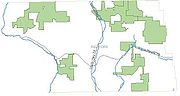
Richford has over 4700 acres (19 km²) of state lands, more than all other towns in Tioga County combined, mostly contained in six large state forests.- Michigan Hill State Forest: Located east of the village and north of RT 79. Encompasses 1200 acres (4.9 km²) of wilderness area. There are no maintained trails. In several areas along Rockefeller Rd, the ruins of old settlements and farms can be found, usually consisting of old foundations and orchards, but the occasional uncovered well exists.
- Griggs Gulf State Forest: Located adjacent to Michigan Hill State Forest, the forest encompasses 2365 acres (9.6 km²) shared between Tioga and Cortland Counties with more than 2.7 miles (4.3 km) of ungroomed trails. John D Rockefeller's birthplace is within Griggs Gulf on Rockefeller Rd. An unkempt nature trail built by a local 4-H group begins here and passes several old structures including a mill and other foundations.
- Turkey Hill State Forest: Shared with the town of Berkshire, this forest is located East and south of Richford. Consists of 1100 acres (4.5 km²) of primitive woodlands with only 1.3 miles (2.1 km) of public access road. Extensive damage in the 2003 ice storms created large areas of early successional habitats that foster a wide variety of birds and other woodland creatures.
- Robinson Hollow State Forest: 1400 acres (5.7 km²) just west of Richford. Many recreational facilities exist including 1.5 miles (2.4 km) of marked trails maintained by local associations, and a portion of the Finger Lakes TrailFinger Lakes TrailThe Finger Lakes Trail System consists of a network of trails in New York. The trail system is administered by the , a non-profit, volunteer organization....
runs through the forest. The Kimmee lean-to maintained by the Finger Lakes Trail Conference is located here. A 45 acres (182,108.7 m²) troutTroutTrout is the name for a number of species of freshwater and saltwater fish belonging to the Salmoninae subfamily of the family Salmonidae. Salmon belong to the same family as trout. Most salmon species spend almost all their lives in salt water...
pond exists and there are extensive fishing areas along the West Branch Owego Creek. Many of the highest elevations in the county are within the forest, including the highest. - Beaver Dam State Forest: 1150 acres (4.7 km²) east of Richford on the border of Tioga and Broome Counties. Contains 1.8 miles (2.9 km) of maintained trails and a 1.5 miles (2.4 km) public access road.
- Andersen Hill State Forest: 544 acres (2.2 km²) just south of the village proper, west of Rt 38. The forest consists of managed woodlands that maintain a mix of early, mid, and late successional forests. A short (.5 mile) maintained trail exists that connects to a larger trail network in adjacent lands, and a 1.6 miles (2.6 km) forest access road is available. An access point to the West Branch Owego Creek is maintained within the forest.
The large number of state-owned lands provide for excellent hiking and motorized sports activities. Many 4-wheeler and snowmobile tracks criss-cross the woodlands on both state and private land.
Many great fishing sites are available in Richford. Native and stock trout thrive in the cold waters of both branches of the Owego Creek with some of the best areas in and around Richford. The NYSDEC annually releases over 10000 brown trout
Brown trout
The brown trout and the sea trout are fish of the same species....
into both branches in Richford. Additionally, 200 rainbow trout
Rainbow trout
The rainbow trout is a species of salmonid native to tributaries of the Pacific Ocean in Asia and North America. The steelhead is a sea run rainbow trout usually returning to freshwater to spawn after 2 to 3 years at sea. In other words, rainbow trout and steelhead trout are the same species....
are released into the Tri-County Pond.
Hunting is also popular within the town. All state lands are open to hunting and provide excellent habitats to large populations of deer, turkey, and other game animals.
Communities and locations in Richford
- Dunhamville – A former location, south of Richford village.
- East Richford – A location on NY-79New York State Route 79New York State Route 79 is an east–west state highway in the Southern Tier of New York, United States. The western terminus of the route is at the intersection with NY 414 near the southern end of Seneca Lake east of Watkins Glen...
(Catskill Turnpike), east of Richford village. - Hubby Creek – A small stream flowing out from the south part of the town.
- Richford – A hamletHamlet (place)A hamlet is usually a rural settlement which is too small to be considered a village, though sometimes the word is used for a different sort of community. Historically, when a hamlet became large enough to justify building a church, it was then classified as a village...
at the junction of NY- 38New York State Route 38New York State Route 38 is a north–south state highway in the Finger Lakes region of New York in the United States. Its southern terminus is at an intersection with NY 96 in the town of Owego in Tioga County. The northern terminus is at a junction with NY 104A in the town of...
and NY-79 in the southwest part of the town. The East Branch of Owego Creek flows past the village.