
New York State Route 96
Encyclopedia
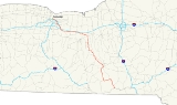
New York State Route 96 (NY 96) is a 126.01 miles (202.79 km) northwest–southeast state highway
in the Finger Lakes
region of New York
in the United States. The southern terminus of the route is at an interchange with NY 17
in the Southern Tier
village of Owego
, Tioga County
. Its northern terminus is at a junction with East Main Street in the city of Rochester
, Monroe County
. Between the two endpoints, NY 96 passes through the city of Ithaca and the villages of Waterloo
, Victor
, and Pittsford
. NY 96 is signed north–south for its entire length, although most of the route in Ontario County
travels in an east–west direction.
All of NY 96, except from Candor
to Ithaca and from northwest of Victor to Pittsford, was originally designated as part of New York State Route 15 in 1924. NY 15 was originally routed on modern NY 96B
between Candor and Ithaca, and modern NY 64
and NY 251
between Victor and Pittsford. It was realigned onto the modern alignment of NY 96 between Victor and Pittsford in 1930. NY 15 was renumbered to New York State Route 2 ca. 1939 to eliminate duplication with U.S. Route 15
(US 15). NY 2 was subsequently redesignated as NY 96 in the early 1940s as the alignments of NY 2 and NY 96, a route in Rensselaer County
, were swapped. NY 96 was realigned again in the early 1950s, this time between Candor and Ithaca, to serve the village of Spencer
west of Candor. Near Rochester, NY 96 followed what is now Interstate 490
(I-490) for a short time during the 1950s and early 1960s.
(NYSDOT); however, three sections of the route in Tompkins County
and Monroe County
are maintained by local highway departments. In the Tompkins County city of Ithaca, NY 96 is city-maintained from the southern city line to the start of the Fulton/Meadow Street one-way couplet, at which point maintenance of the highway reverts to NYSDOT. The route is also maintained by Ithaca from Park Road to the western city limits. The last locally-owned section is in the Monroe County city of Rochester
, where the entirety of NY 96 within the city is city-maintained.
at exit 64 on Southside Drive across the Susquehanna River
from the Tioga County
village of Owego
. The route remains unsigned until the intersection of Court Street and Southside Drive, the western terminus of NY 434
. NY 434 continues east along Southside Drive while NY 96, now fully signed, turns north onto Court Street and crosses the Susquehanna River. On the opposite side of the river, NY 96 intersects Front Street. The configuration of NY 96 between Front Street and East Main Street is unorthodox in that NY 96 splits at Front Street to follow a one-way couplet around the Tioga County Courthouse
to Main Street, where both streets terminate. NY 96 turns onto Main Street for half a block to North Avenue, where it resumes its northward path. The route shares the parallel one-way streets with NY 17C
, which enters Owego from the west via Main Street and leaves via Front Street to the east.
Now on North Avenue, NY 96 passes through the heart of Owego before leaving the village and following Owego Creek into a long stretch of rural country. Just over 1 miles (1.6 km) north of Owego village in the town of Owego
, NY 96 meets the southern terminus of NY 38
. At this point, NY 38 becomes the creekside highway while NY 96 passes over Owego Creek and follows Catatonk Creek northwest into the town of Candor
. Once in Candor, the route and the creek turn northward toward the village of Candor
, where NY 96 meets NY 96B
, an alternate route of NY 96 between Candor and the city of Ithaca. Past NY 96B, NY 96 turns to the west and crosses over Catatonk Creek as it exits the village. West of Candor, NY 96 follows an east–west alignment through a creek valley to the village of Spencer
, where the route converges with NY 34
and heads north into another valley leading to Tompkins County
.
, NY 34 and NY 96 meet NY 13
. The three routes continue northeast through the town, intersecting NY 327
and NY 13A before crossing over the inlet of Cayuga Lake
and entering the city of Ithaca on Meadow Street. Here, NY 96B reconnects to its parent at the junction of Clinton and Meadow Streets. North of this point, Meadow Street splits into a one-way couplet, with Fulton Street carrying southbound traffic and Meadow Street handling northbound traffic. NY 79
, also routed on a one-way couplet here, crosses NY 96 at Green and Seneca Streets, with NY 79 eastbound using one block of Fulton Street to travel from State Street to Green Street.
One block north of NY 79, NY 96 splits from NY 13 and NY 34 and heads to the west at Buffalo Street. NY 89
begins here, and NY 96 overlaps with NY 89 toward the West End of Ithaca. After crossing southbound NY 13 and NY 34, NY 89 and NY 96 run parallel to and a few feet to the north of NY 79. NY 89 turns north onto Taughannock Boulevard at the next intersection while NY 96 continues west across the lake outlet as Cliff Street, paralleling NY 79. They do not intersect in this area—known locally as The Octopus—though they once did. At one time, NY 96, NY 79, NY 89, NY 13A and Elm Street met at an intersection that gave the area its name. Today, only NY 13A and NY 79 intersect there while the stub of former NY 89 is now a park access road that intersects with NY 96, which continues north out of the Cayuga Lake valley as Trumansburg Road.
Unlike NY 89, which runs along the base of the valley and parallels the west shore of Cayuga Lake, NY 96 heads away from the lake, increasing the distance between itself and the water body as it proceeds northwestward to the highlands overlooking the lake. The route heads across open fields and past isolated pockets of homes toward Trumansburg
, where NY 96 crosses over Taughannock Creek and serves Taughannock Falls State Park
southeast of the village. In Trumansburg itself, the highway becomes Main Street and meets the northern terminus of NY 227
in the center of the community. NY 96 continues on, exiting Trumansburg just 250 yards (229 m) before crossing the Seneca County
line.
to the village of Interlaken
, home to the southern terminus of NY 96A
, a more westerly alternate route of NY 96 between Interlaken and Geneva. Outside of the village, NY 96 continues on a northwesterly path for another 4.5 miles (7.2 km) to the Ovid
–Romulus
town line, where it turns due west for 2 miles (3.2 km) to access the village of Ovid
. The route mostly bypasses the village, with NY 96A and NY 414
serving as its Main Street instead. The three routes meet at a junction on the northern fringe of the community, at which point NY 96A leaves NY 414 and turns west to follow the town line toward Seneca Lake while NY 96 joins NY 414 and heads north into the town of Romulus.
Midway between the village of Ovid and the hamlet of Romulus, the two routes split, allowing NY 414 to continue due north to Seneca Falls
. NY 96, meanwhile, turns to the northwest, following the eastern edge of the Seneca Army Depot
for most of the distance to Romulus hamlet. Just south of the community's center, NY 96 separates from the depot grounds and continues north through the hamlet and into the town of Varick
. The route uneventfully crosses the town, passing by open fields on a predominantly northward alignment on its way to the Fayette
town line and a junction with NY 336
, an east–west connector between NY 96A and NY 414. NY 96 continues across rural terrain to the outskirts of the village of Waterloo
, where the number of homes rises as the route enters the village on Fayette Street.
In the southern half of the village, the highway follows a zig-zag routing as it leaves Fayette Street at River Road before returning to the north at Washington Street one block to the east. While on Washington Street, the route passes over the Cayuga–Seneca Canal and enters the village's center, changing names to Virginia Street in the process. Not far to the north, NY 96 heads into Waterloo's central business district, built up around the junction of Virginia and Main (US 20
and NY 5
) Streets. Past Routes 5 and 20, NY 96 continues north as a residential street to the village line, where the route turns to the west with a slight trend to the north. At this point, the scenery surrounding NY 96 shifts from house-lined streets to rural countryside once again, an appearance that follows the road to the northwest through the town of Waterloo
and across the county line.
, it is still signed as a north–south highway. Less than 1 miles (1.6 km) into the county, NY 96 connects to NY 14
by way of a cloverleaf interchange
, an oddity considering the rural location of the interchange. West of NY 14, NY 96 begins to parallel the paths of both the New York State Thruway
(I-90
) and the Canandaigua Lake
outlet to the north. The highway follows both entities across the town of Phelps
to the village of the same name
, where NY 96 meets the southern terminus of NY 88
. Just west of the village, NY 96 intersects the northern terminus of NY 488
, formerly part of NY 88. West of the intersection, a northward reverse S-curve draws NY 96 closer to the Thruway and the outlet as the route heads toward the village of Clifton Springs
, which NY 96 bypasses to the north.
4 miles (6 km) to the west in the village of Manchester
, NY 96 crosses over the outlet (which roughly follows NY 21
south to Canandaigua Lake from this point out) and indirectly connects to the Thruway by way of a junction with NY 21 located north of the village center and just south of where NY 21 meets the Thruway at exit 43. West of NY 21, NY 96 curves gently to the south, crossing the Ontario Central Railroad
before resuming its westward alignment near the grade crossing. At this point, NY 96 enters the town of Farmington
and begins to parallel the Thruway once more. The route passes by Finger Lakes Gaming and Race Track
, located between County Route 8 (CR 8) and NY 332
, prior to intersecting NY 332 itself 0.5 mile (0.80467 km) west of the race track.
 From this point northwestward to Rochester
, NY 96 passes through substantially more developed areas. The first of these is the nearby village of Victor
, which NY 96 enters by way of an overpass carrying it over the Ontario Central Railroad. In the village itself, the route meets the northern terminus of NY 444
, which travels north–south between Victor and Bloomfield
. West of the village in the town of Victor
, NY 96 runs along the base of a valley separating it from the Thruway, where it intersects the eastern terminus of NY 251
. The route continues on a northwesterly track for another mile (1.6 km) before curving to the north and widening from two to four lanes as it passes under the Thruway near exit 45. I-490
, which begins at Thruway exit 45, is accessible from NY 96 by way of exit 29, the eastern-most exit on I-490.
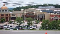
The section of NY 96 between exit 29 and NY 250
in Perinton
serves as a major commercial strip, anchored by the presence of Eastview Mall
, one of the largest malls in the Rochester area and the largest east of the city. Also present along this stretch of NY 96 are a series of plazas, beginning with one just north of I-490 featuring a Wal-Mart
and a Kohl's
. Continuing northward, NY 96 runs along the eastern edge of Eastview Mall and passes two more plazas, one of which is developed around a K-Mart. The highway gradually turns northwest toward the county line as it passes the mall, and crosses into Monroe County
at an intersection leading to Eastview Commons, a plaza separated from the mall by high-voltage power lines and a large ditch.
through slightly less developed areas between Bushnell's Basin and Mitchell Road in the town of Pittsford
, where it narrows to two lanes and becomes East Jefferson Road.
West of Mitchell Road, NY 96 takes a more southerly alignment than the canal as it enters the densely populated village of Pittsford
and meets the northern and eastern termini of NY 64
and NY 252
, respectively, at the intersection of Jefferson Road and South Main Street. NY 64 heads to the south along South Main Street and NY 252 continues along Jefferson Road to the west while NY 96 turns north, proceeding into the heart of the village along South Main Street. In the village center, NY 96 intersects Monroe Avenue and State Street, which carry NY 31
east–west through Pittsford. The route continues on, becoming North Main Street as it crosses the Erie Canal and passes under the CSX Transportation
-owned West Shore Subdivision
. Just north of the railroad overpass is a junction with the southern terminus of NY 153
, the most direct route between Pittsford and nearby East Rochester
.
Past NY 153, NY 96 exits the village of Pittsford and becomes East Avenue, a name the route retains to its terminus in downtown Rochester
. It proceeds northward through the heavily residential town, passing by Nazareth College
and meeting the western terminus of NY 31F
(Fairport Road) at a junction adjacent to the campus of St. John Fisher College. East Avenue, and likewise NY 96, takes on the northwesterly, four-lane alignment set by Fairport Road and begins to parallel the routing of I-490 once more as both enter the town of Brighton
. Not far to the northwest of the town line, NY 96 meets Elmwood and Linden Avenues, the latter carrying NY 441
. About 1 miles (1.6 km) to the northwest, NY 96 intersects Penfield Road, the pre-expressway alignment of NY 441. One block from this point is Clover Street, which carries NY 65
south of East Avenue.
At the Brighton–Rochester town line, NY 96 passes through the center of the Can of Worms, a complex interchange that links I-490 to I-590
. Here, I-590 passes under NY 96 while I-490 flies over NY 96. On the other side of the interchange in Rochester, East Avenue becomes a commercial strip once again, but to a lesser extent than in Victor. At North Winton Road, NY 96 is signed for the last time by way of a "North 96" reassurance assembly directing traffic to stay on East Avenue. Despite this fact, the route officially continues northwestward toward downtown Rochester
.
West of Winton, NY 96 passes through the East Avenue Historic District
, a primarily residential area with historic upper-class houses, including the George Eastman House
. This stretch of the route was narrowed in mid-2010 from four lanes to two, to improve the residential feel and reduce automobile speeds. At Alexander Street, the environment turns more commercial as the route enters the downtown area. After crossing the Inner Loop
, the route passes the Little Theatre before terminating at a Y-junction with East Main Street.
that extended from Owego
to Seneca Falls
via Candor
, Ithaca
, and Ovid
. South of Romulus
, Route 36 utilized what is now NY 96 and NY 96B
. When the first set of posted routes in New York
were assigned in 1924, the Owego–Interlaken
and Ovid–Romulus portions of legislative Route 36 became part of NY 15, which began in Owego and proceeded northwest from Romulus to Rochester
by way of Waterloo
, Phelps
, Victor
, Mendon
, and Pittsford
. From Mendon to Rochester, NY 15 followed the path of legislative Route 14, another highway dating back to 1908 that continued south from Mendon on what is now NY 64
and used Monroe Avenue between Pittsford and Rochester. Another section of NY 15—from the village of Phelps east to NY 14
—utilized what had been designated as part of legislative Route 6-a from 1911 to 1921.
By 1926, NY 31
was assigned across western and central New York, utilizing Monroe Avenue from downtown Rochester to Pittsford. Although NY 96's modern routing via East Avenue was state-maintained and formerly part of legislative Route 20 from current NY 31F
westward, NY 15 initially remained on Monroe Avenue, creating an overlap between NY 15 and NY 31. It was realigned at some point between 1927 and 1932 to follow East Avenue to Rochester instead. In southern Seneca County
, NY 15 initially passed through Lodi
on its way from Interlaken to Ovid. It was realigned in the late 1920s to bypass Lodi to the northeast on the former alignment of legislative Route 36.
In the 1930 renumbering of state highways in New York, NY 15 basically remained intact. The only change made at this time was the straightening out of the Victor–Pittsford segment, which now bypassed Mendon in favor of a more direct alignment between the two villages via Bushnell's Basin. The former alignment of NY 15 became part of NY 251
east of Mendon and part of NY 64 north of the hamlet. Ca. 1939, US 15
was extended into New York, replacing NY 2, which had extended from the Pennsylvania state line to Rochester. NY 15 was renumbered to NY 2 to eliminate numerical duplication with the U.S. Highway.
The NY 96 designation was originally assigned to present-day NY 2
from NY 7
in Troy
to Route 2
at the Massachusetts
state line. In the early 1940s, the alignments of NY 2 and NY 96 were swapped, placing NY 96 on the Owego–Rochester routing. The only major change to NY 96 since that time came in the early 1950s, when the route was realigned between Candor and Ithaca to follow a new routing via Spencer
. The Candor–Spencer portion of the alignment had been part of NY 53 during the 1920s and part of NY 223
since 1930. NY 223 was truncated to its current eastern terminus at NY 224
near Van Etten
as part of NY 96's realignment. Between Spencer and Ithaca, NY 96 overlapped with NY 34
, which had occupied that segment of highway since the 1930 renumbering.
In the 1950s, NY 96 was temporarily moved onto the Eastern Expressway as sections of the freeway opened to traffic. The first section extended from Bushnell's Basin to NY 31F and opened to traffic in the mid-1950s, at which time NY 96 was routed onto the new highway and NY 252
and NY 64 were extended eastward and northward, respectively, to cover NY 96's old surface alignment. NY 31F, meanwhile, was truncated to begin at the expressway. A northwest extension to what is now the Can of Worms was completed ca. 1957 as a realignment of NY 96, resulting in the re-extension of NY 31F to its original terminus and an extension of NY 64 along East Avenue to the eastern edge of Rochester. NY 64, NY 96, and NY 252 were restored to their pre-1950s alignments ca. 1961 when the freeway was designated as I-490
.
State highway
State highway, state road or state route can refer to one of three related concepts, two of them related to a state or provincial government in a country that is divided into states or provinces :#A...
in the Finger Lakes
Finger Lakes
The Finger Lakes are a pattern of lakes in the west-central section of Upstate New York in the United States. They are a popular tourist destination. The lakes are long and thin , each oriented roughly on a north-south axis. The two longest, Cayuga Lake and Seneca Lake, are among the deepest in...
region of New York
New York
New York is a state in the Northeastern region of the United States. It is the nation's third most populous state. New York is bordered by New Jersey and Pennsylvania to the south, and by Connecticut, Massachusetts and Vermont to the east...
in the United States. The southern terminus of the route is at an interchange with NY 17
New York State Route 17
New York State Route 17 is a state highway that extends for through the Southern Tier and Downstate regions of New York in the United States...
in the Southern Tier
Southern Tier
The Southern Tier is a geographical term that refers to the counties of New York State west of the Catskill Mountains along the northern border of Pennsylvania. It is a loosely defined term that generally includes the counties that border Pennsylvania west of Delaware County inclusive...
village of Owego
Owego (village), New York
Owego is a village in and the county seat of Tioga County, New York, USA. The population was 3,911 at the 2000 census. It is part of the Binghamton Metropolitan Statistical Area...
, Tioga County
Tioga County, New York
As of the census of 2010, there were 51,125 people residing in the county, with 22,203 housing units, of these 20,350 occupied, 1,853 vacant. The population density was 98 people per square mile...
. Its northern terminus is at a junction with East Main Street in the city of Rochester
Rochester, New York
Rochester is a city in Monroe County, New York, south of Lake Ontario in the United States. Known as The World's Image Centre, it was also once known as The Flour City, and more recently as The Flower City...
, Monroe County
Monroe County, New York
Monroe County is a county located in the U.S. state of New York. As of the 2010 census, the population was 744,344. It is named after James Monroe, fifth President of the United States of America. Its county seat is the city of Rochester....
. Between the two endpoints, NY 96 passes through the city of Ithaca and the villages of Waterloo
Waterloo (village), New York
Waterloo is a village in and the county seat of Seneca County, New York, United States. The population was 5,111 at the 2000 census. The village is named after the Waterloo in Belgium, where Napoleon was defeated...
, Victor
Victor (village), New York
Victor is a village located in within the Town of Victor in Ontario County, New York, USA. The population was 2,433 at the 2000 census.The Village of Victor is in the southeast part of the town and is southeast of the City of Rochester.- History :...
, and Pittsford
Pittsford (village), New York
Pittsford is a village in Monroe County, New York, United States. The population was 1,418 at the 2000 census. It is named after Pittsford, Vermont, the native town of a founding father....
. NY 96 is signed north–south for its entire length, although most of the route in Ontario County
Ontario County, New York
As of the census of 2000, there were 100,224 people, 38,370 households, and 26,360 families residing in the county. The population density was 156 people per square mile . There were 42,647 housing units at an average density of 66 per square mile...
travels in an east–west direction.
All of NY 96, except from Candor
Candor (village), New York
Candor is a village located in the Town of Candor in Tioga County, New York. The population was 855 at the 2000 census. It is part of the Binghamton Metropolitan Statistical Area....
to Ithaca and from northwest of Victor to Pittsford, was originally designated as part of New York State Route 15 in 1924. NY 15 was originally routed on modern NY 96B
New York State Route 96B
New York State Route 96B is a north–south state highway in the Southern Tier of New York, United States. It connects NY 96 in the village of Candor in Tioga County to NY 13, NY 34, and NY 96 in the city of Ithaca in Tompkins County...
between Candor and Ithaca, and modern NY 64
New York State Route 64
New York State Route 64 is a north–south state highway in the Finger Lakes region of New York in the United States. Its southern terminus is at an intersection with NY 21 in the hamlet of Bristol Springs within the town of South Bristol, Ontario County...
and NY 251
New York State Route 251
New York State Route 251 is an east–west state highway in western New York in the United States. It extends for from NY 383 in Scottsville, Monroe County, to NY 96 in the town of Victor, Ontario County...
between Victor and Pittsford. It was realigned onto the modern alignment of NY 96 between Victor and Pittsford in 1930. NY 15 was renumbered to New York State Route 2 ca. 1939 to eliminate duplication with U.S. Route 15
U.S. Route 15 in New York
U.S. Route 15 is a part of the U.S. Highway System that runs from Walterboro, South Carolina, to Painted Post, New York. In the U.S. state of New York, US 15 extends through the Southern Tier from the Pennsylvania state line at Lindley north to an interchange with the Southern Tier...
(US 15). NY 2 was subsequently redesignated as NY 96 in the early 1940s as the alignments of NY 2 and NY 96, a route in Rensselaer County
Rensselaer County, New York
Rensselaer County is a county in the U.S. state of New York. As of the 2010 census, the population was 159,429. Its name is in honor of the family of Kiliaen van Rensselaer, the original Dutch owner of the land in the area. Its county seat is Troy...
, were swapped. NY 96 was realigned again in the early 1950s, this time between Candor and Ithaca, to serve the village of Spencer
Spencer (village), New York
Spencer is a village located in the Town of Spencer in Tioga County, New York, USA. The population was 731 at the 2000 census. It is part of the Binghamton Metropolitan Statistical Area...
west of Candor. Near Rochester, NY 96 followed what is now Interstate 490
Interstate 490 (New York)
Interstate 490 is an auxiliary Interstate Highway that serves the city of Rochester, New York, in the United States. It acts as a northerly alternate route to the New York State Thruway , leaving it at exit 47 in the town of Le Roy and rejoining the highway at exit 45 in the town of...
(I-490) for a short time during the 1950s and early 1960s.
Route description
Most of NY 96's 126 miles (203 km) are maintained by the New York State Department of TransportationNew York State Department of Transportation
The New York State Department of Transportation is responsible for the development and operation of highways, railroads, mass transit systems, ports, waterways and aviation facilities in the U.S...
(NYSDOT); however, three sections of the route in Tompkins County
Tompkins County, New York
Tompkins County is a county located in the U.S. state of New York, and comprises the whole of the Ithaca metropolitan area. As of the 2010 census, the population was 101,564. The county seat is Ithaca, and the county is home to Cornell University, Ithaca College and Tompkins Cortland Community...
and Monroe County
Monroe County, New York
Monroe County is a county located in the U.S. state of New York. As of the 2010 census, the population was 744,344. It is named after James Monroe, fifth President of the United States of America. Its county seat is the city of Rochester....
are maintained by local highway departments. In the Tompkins County city of Ithaca, NY 96 is city-maintained from the southern city line to the start of the Fulton/Meadow Street one-way couplet, at which point maintenance of the highway reverts to NYSDOT. The route is also maintained by Ithaca from Park Road to the western city limits. The last locally-owned section is in the Monroe County city of Rochester
Rochester, New York
Rochester is a city in Monroe County, New York, south of Lake Ontario in the United States. Known as The World's Image Centre, it was also once known as The Flour City, and more recently as The Flower City...
, where the entirety of NY 96 within the city is city-maintained.
Tioga County
Though unsigned at this point, NY 96 begins at the eastbound onramp to NY 17New York State Route 17
New York State Route 17 is a state highway that extends for through the Southern Tier and Downstate regions of New York in the United States...
at exit 64 on Southside Drive across the Susquehanna River
Susquehanna River
The Susquehanna River is a river located in the northeastern United States. At long, it is the longest river on the American east coast that drains into the Atlantic Ocean, and with its watershed it is the 16th largest river in the United States, and the longest river in the continental United...
from the Tioga County
Tioga County, New York
As of the census of 2010, there were 51,125 people residing in the county, with 22,203 housing units, of these 20,350 occupied, 1,853 vacant. The population density was 98 people per square mile...
village of Owego
Owego (village), New York
Owego is a village in and the county seat of Tioga County, New York, USA. The population was 3,911 at the 2000 census. It is part of the Binghamton Metropolitan Statistical Area...
. The route remains unsigned until the intersection of Court Street and Southside Drive, the western terminus of NY 434
New York State Route 434
New York State Route 434 is a state highway located in the Southern Tier of the U.S. state of New York. The route extends for from an intersection with NY 96 in the village of Owego to an intersection with US 11 in the city of Binghamton. In between, NY 434 passes through the...
. NY 434 continues east along Southside Drive while NY 96, now fully signed, turns north onto Court Street and crosses the Susquehanna River. On the opposite side of the river, NY 96 intersects Front Street. The configuration of NY 96 between Front Street and East Main Street is unorthodox in that NY 96 splits at Front Street to follow a one-way couplet around the Tioga County Courthouse
Tioga County Courthouse
Tioga County Courthouse is a historic courthouse located at Owego in Tioga County, New York. It was built in 1871-1872 and is a rectangular two story building with four, three story towers, one on each corner. It is constructed of smooth, hard-burned brick of a red-pink color with decorative...
to Main Street, where both streets terminate. NY 96 turns onto Main Street for half a block to North Avenue, where it resumes its northward path. The route shares the parallel one-way streets with NY 17C
New York State Route 17C
New York State Route 17C is a state highway in the Southern Tier of New York. Its western terminus is at an intersection with NY 34 in Waverly, Tioga County while its eastern terminus is at an intersection with U.S. Route 11 in Binghamton, Broome County...
, which enters Owego from the west via Main Street and leaves via Front Street to the east.
Now on North Avenue, NY 96 passes through the heart of Owego before leaving the village and following Owego Creek into a long stretch of rural country. Just over 1 miles (1.6 km) north of Owego village in the town of Owego
Owego (town), New York
Owego is a town in Tioga County, New York, USA. The population was 20,365 at the 2000 census. The name is derived from the Iroquois word Ahwaga, meaning where the valley widens....
, NY 96 meets the southern terminus of NY 38
New York State Route 38
New York State Route 38 is a north–south state highway in the Finger Lakes region of New York in the United States. Its southern terminus is at an intersection with NY 96 in the town of Owego in Tioga County. The northern terminus is at a junction with NY 104A in the town of...
. At this point, NY 38 becomes the creekside highway while NY 96 passes over Owego Creek and follows Catatonk Creek northwest into the town of Candor
Candor (town), New York
Candor is a town in Tioga County, New York, USA. The population was 5,317 at the 2000 census.The Town of Candor has a village named Candor. The town is south of Ithaca, New York.- History :...
. Once in Candor, the route and the creek turn northward toward the village of Candor
Candor (village), New York
Candor is a village located in the Town of Candor in Tioga County, New York. The population was 855 at the 2000 census. It is part of the Binghamton Metropolitan Statistical Area....
, where NY 96 meets NY 96B
New York State Route 96B
New York State Route 96B is a north–south state highway in the Southern Tier of New York, United States. It connects NY 96 in the village of Candor in Tioga County to NY 13, NY 34, and NY 96 in the city of Ithaca in Tompkins County...
, an alternate route of NY 96 between Candor and the city of Ithaca. Past NY 96B, NY 96 turns to the west and crosses over Catatonk Creek as it exits the village. West of Candor, NY 96 follows an east–west alignment through a creek valley to the village of Spencer
Spencer (village), New York
Spencer is a village located in the Town of Spencer in Tioga County, New York, USA. The population was 731 at the 2000 census. It is part of the Binghamton Metropolitan Statistical Area...
, where the route converges with NY 34
New York State Route 34
New York State Route 34 is a north–south New York state route located in Central New York. Its southern terminus is at the Pennsylvania state line in the village of Waverly, where it connects to Pennsylvania Route 199 and meets NY 17...
and heads north into another valley leading to Tompkins County
Tompkins County, New York
Tompkins County is a county located in the U.S. state of New York, and comprises the whole of the Ithaca metropolitan area. As of the 2010 census, the population was 101,564. The county seat is Ithaca, and the county is home to Cornell University, Ithaca College and Tompkins Cortland Community...
.
Tompkins County
The two routes remain concurrent as they snake to the northwest through Tompkins County. Southwest of the city of Ithaca in the town of IthacaIthaca (town), New York
Ithaca is a town in Tompkins County, New York, United States. The population was 18,198 at the 2000 census.The Town of Ithaca is a horseshoe-shaped portion of the metropolitan area of Ithaca, New York. It surrounds the City of Ithaca and is the City's only border, although the City has a...
, NY 34 and NY 96 meet NY 13
New York State Route 13
New York State Route 13 is a state highway that runs mainly north–south for between NY 14 in Horseheads and NY 3 west of Pulaski in Central New York in the United States. In between, NY 13 intersects with Interstate 81 in Cortland and Pulaski and meets the New York...
. The three routes continue northeast through the town, intersecting NY 327
New York State Route 327
New York State Route 327 is a state highway in New York State. It begins at the NY 13/NY 34/NY 96 concurrency in the Town of Ithaca and ends at NY 79 in the Town of Enfield. It is located entirely within Tompkins County.-Route description:Route 327 begins at an...
and NY 13A before crossing over the inlet of Cayuga Lake
Cayuga Lake
Cayuga Lake is the longest of central New York's glacial Finger Lakes, and is the second largest in surface area and second largest in volume. It is just under 40 miles long. Its average width is 1.7 miles , and it is at its widest point near Aurora...
and entering the city of Ithaca on Meadow Street. Here, NY 96B reconnects to its parent at the junction of Clinton and Meadow Streets. North of this point, Meadow Street splits into a one-way couplet, with Fulton Street carrying southbound traffic and Meadow Street handling northbound traffic. NY 79
New York State Route 79
New York State Route 79 is an east–west state highway in the Southern Tier of New York, United States. The western terminus of the route is at the intersection with NY 414 near the southern end of Seneca Lake east of Watkins Glen...
, also routed on a one-way couplet here, crosses NY 96 at Green and Seneca Streets, with NY 79 eastbound using one block of Fulton Street to travel from State Street to Green Street.
One block north of NY 79, NY 96 splits from NY 13 and NY 34 and heads to the west at Buffalo Street. NY 89
New York State Route 89
New York State Route 89 is a north–south state highway in central New York in the United States. It extends for from an intersection with NY 13, NY 34, and NY 96 in the Tompkins County city of Ithaca to an interchange with NY 104 in the Wayne County town of town of Wolcott...
begins here, and NY 96 overlaps with NY 89 toward the West End of Ithaca. After crossing southbound NY 13 and NY 34, NY 89 and NY 96 run parallel to and a few feet to the north of NY 79. NY 89 turns north onto Taughannock Boulevard at the next intersection while NY 96 continues west across the lake outlet as Cliff Street, paralleling NY 79. They do not intersect in this area—known locally as The Octopus—though they once did. At one time, NY 96, NY 79, NY 89, NY 13A and Elm Street met at an intersection that gave the area its name. Today, only NY 13A and NY 79 intersect there while the stub of former NY 89 is now a park access road that intersects with NY 96, which continues north out of the Cayuga Lake valley as Trumansburg Road.
Unlike NY 89, which runs along the base of the valley and parallels the west shore of Cayuga Lake, NY 96 heads away from the lake, increasing the distance between itself and the water body as it proceeds northwestward to the highlands overlooking the lake. The route heads across open fields and past isolated pockets of homes toward Trumansburg
Trumansburg, New York
Trumansburg is a village in Tompkins County, New York, United States. The population was 1,581 at the 2000 census. The name is a variant spelling of the surname of the founder, Abner Treman...
, where NY 96 crosses over Taughannock Creek and serves Taughannock Falls State Park
Taughannock Falls State Park
Taughannock Falls State Park is located in the Town of Ulysses in Tompkins County, New York, in the United States. The park is northwest of Ithaca near Trumansburg, New York...
southeast of the village. In Trumansburg itself, the highway becomes Main Street and meets the northern terminus of NY 227
New York State Route 227
New York State Route 227 is a north–south state highway in the Finger Lakes region of New York, United States. The southern terminus of the route is at NY 79 south of the hamlet of Reynoldsville in the town of Hector. Its northern terminus is at NY 96 in Trumansburg...
in the center of the community. NY 96 continues on, exiting Trumansburg just 250 yards (229 m) before crossing the Seneca County
Seneca County, New York
As of the census of 2000, there were 33,342 people, 12,630 households, and 8,626 families residing in the county. The population density was 103 people per square mile . There were 14,794 housing units at an average density of 46 per square mile...
line.
Seneca County
NY 96 proceeds northwest through a lightly populated section of Seneca County and the town of CovertCovert, New York
Covert is a town in Seneca County, New York, USA. The population was 2,227 at the 2000 census. The current Town Supervisor is Michael Reynolds .The Town of Covert is located in the southeast corner of the county and is northwest of Ithaca, New York....
to the village of Interlaken
Interlaken, New York
Interlaken is a village in Seneca County, New York, United States. The population was 674 at the 2000 census. The name is related to the village's position between two lakes....
, home to the southern terminus of NY 96A
New York State Route 96A
New York State Route 96A is a state highway in Seneca County, New York, in the United States. It is a north–south road between Seneca Lake and Cayuga Lake, two of the Finger Lakes. NY 96A is two lanes wide for most of its length, with the exception of the long four-lane divided highway...
, a more westerly alternate route of NY 96 between Interlaken and Geneva. Outside of the village, NY 96 continues on a northwesterly path for another 4.5 miles (7.2 km) to the Ovid
Ovid (town), New York
Ovid is a town in Seneca County, New York, United States. The population was 2,757 at the 2000 census. The town is named after the Roman poet Ovid, a name assigned by a clerk interested in the classics....
–Romulus
Romulus, New York
Romulus is a town in Seneca County, New York, United States. The population was 2,036 at the 2000 census. The town is named after the mythical founder of Rome, Romulus, a name assigned by a clerk with an interest in the classics...
town line, where it turns due west for 2 miles (3.2 km) to access the village of Ovid
Ovid (village), New York
Ovid is a village in and one of the two county seats of Seneca County, New York, United States. The population was 612 at the 2000 census. The town was named by a clerk interested in the classics ....
. The route mostly bypasses the village, with NY 96A and NY 414
New York State Route 414
New York State Route 414 is a north–south state highway in the Southern Tier and Finger Lakes regions of New York in the United States. It extends for from an intersection with NY 352 in the Steuben County city of Corning to a junction with NY 104 in the Wayne County town of Huron...
serving as its Main Street instead. The three routes meet at a junction on the northern fringe of the community, at which point NY 96A leaves NY 414 and turns west to follow the town line toward Seneca Lake while NY 96 joins NY 414 and heads north into the town of Romulus.
Midway between the village of Ovid and the hamlet of Romulus, the two routes split, allowing NY 414 to continue due north to Seneca Falls
Seneca Falls (village), New York
Seneca Falls is a village in Seneca County, New York, United States. The population was 6,861 at the 2000 census. The village is in the Town of Seneca Falls, east of Geneva, New York. On March 16, 2010, village residents voted to dissolve the village, a move that would take effect at the end of 2011...
. NY 96, meanwhile, turns to the northwest, following the eastern edge of the Seneca Army Depot
Seneca Army Depot
The former Seneca Army Depot occupied 10,587 acres between Seneca Lake and Cayuga Lake in Seneca County, New York. It was used as a munitions storage and disposal facility by the United States Army from 1941 until the 1990s. The Depot was listed in the 1995 Base Realignment and Closure Commission...
for most of the distance to Romulus hamlet. Just south of the community's center, NY 96 separates from the depot grounds and continues north through the hamlet and into the town of Varick
Varick, New York
Varick is a town in Seneca County, New York, United States. The population was 1,729 at the 2000 census. The town is named after Richard Varick, an officer in the American Revolution, mayor of New York City, and uncle of the first Town Supervisor, Anthony Dey.The Town of Varick is located in the...
. The route uneventfully crosses the town, passing by open fields on a predominantly northward alignment on its way to the Fayette
Fayette, New York
Fayette is a town in Seneca County, New York, United States. The population was 3,643 at the 2000 census.The Town of Fayette is on the western border of the county and is southeast of Geneva, New York.- History :...
town line and a junction with NY 336
New York State Route 336
New York State Route 336 is a short state highway in the Finger Lakes District of New York, USA. The highway is entirely within the Town of Fayette in Seneca County....
, an east–west connector between NY 96A and NY 414. NY 96 continues across rural terrain to the outskirts of the village of Waterloo
Waterloo (village), New York
Waterloo is a village in and the county seat of Seneca County, New York, United States. The population was 5,111 at the 2000 census. The village is named after the Waterloo in Belgium, where Napoleon was defeated...
, where the number of homes rises as the route enters the village on Fayette Street.
In the southern half of the village, the highway follows a zig-zag routing as it leaves Fayette Street at River Road before returning to the north at Washington Street one block to the east. While on Washington Street, the route passes over the Cayuga–Seneca Canal and enters the village's center, changing names to Virginia Street in the process. Not far to the north, NY 96 heads into Waterloo's central business district, built up around the junction of Virginia and Main (US 20
U.S. Route 20 in New York
U.S. Route 20 is a part of the U.S. Highway System that runs from Newport, Oregon, to Boston, Massachusetts. In the U.S. state of New York, US 20 extends from the Pennsylvania state line at Ripley to the Massachusetts state line in the Berkshire Mountains. US 20 is the longest...
and NY 5
New York State Route 5
New York State Route 5 is a state highway that extends for across the state of New York in the United States. It begins at the Pennsylvania state line in the Chautauqua County town of Ripley and passes through Buffalo, Syracuse, Utica, Schenectady, and several other smaller cities and...
) Streets. Past Routes 5 and 20, NY 96 continues north as a residential street to the village line, where the route turns to the west with a slight trend to the north. At this point, the scenery surrounding NY 96 shifts from house-lined streets to rural countryside once again, an appearance that follows the road to the northwest through the town of Waterloo
Waterloo (town), New York
Waterloo is a town in Seneca County, New York, United States. The population was 7,866 at the 2000 census. The town, as well as its major community, are named after Waterloo, Belgium. The current Town Supervisor is James Mooney and the current Town Clerk is Louise Van Nostrand.The Town of Waterloo...
and across the county line.
Ontario County
Although NY 96 travels mostly in an east–west direction throughout Ontario CountyOntario County, New York
As of the census of 2000, there were 100,224 people, 38,370 households, and 26,360 families residing in the county. The population density was 156 people per square mile . There were 42,647 housing units at an average density of 66 per square mile...
, it is still signed as a north–south highway. Less than 1 miles (1.6 km) into the county, NY 96 connects to NY 14
New York State Route 14
New York State Route 14 is a state highway located in western New York in the United States. Along with NY 19, it is one of two routes to transect the state in a north–south fashion between the Pennsylvania border and Lake Ontario...
by way of a cloverleaf interchange
Cloverleaf interchange
A cloverleaf interchange is a two-level interchange in which left turns, reverse direction in left-driving regions, are handled by ramp roads...
, an oddity considering the rural location of the interchange. West of NY 14, NY 96 begins to parallel the paths of both the New York State Thruway
New York State Thruway
The New York State Thruway is a system of limited-access highways located within the state of New York in the United States. The system, known officially as the Governor Thomas E. Dewey Thruway for former New York Governor Thomas E. Dewey, is operated by the New York State Thruway Authority and...
(I-90
Interstate 90 in New York
Interstate 90 is a part of the Interstate Highway System that runs from Seattle, Washington, to Boston, Massachusetts. In the U.S. state of New York, I-90 extends from the Pennsylvania state line at Ripley to the Massachusetts state line at Canaan...
) and the Canandaigua Lake
Canandaigua Lake
Canandaigua Lake is the fourth largest of the Finger Lakes, in the U.S. state of New York. The city of Canandaigua is located at the northern shore of the lake and the village of Naples is just a few miles south of the southern end...
outlet to the north. The highway follows both entities across the town of Phelps
Phelps (town), New York
Phelps is a town in Ontario County, New York, USA. The population was 7,017 at the 2000 census. The town is named after one of the original proprietors.The Town of Phelps contains a village called Phelps. Both are north of Geneva, New York....
to the village of the same name
Phelps (village), New York
Phelps is a village in Ontario County, New York, USA. The population was 1,969 at the 2000 census. The village is named after an original proprietor, Oliver Phelps....
, where NY 96 meets the southern terminus of NY 88
New York State Route 88
New York State Route 88 is a north–south state highway in the Finger Lakes region of New York in the United States. It extends for from an intersection with NY 96 in the Ontario County village of Phelps to a junction with NY 104 in the Wayne County town of Sodus...
. Just west of the village, NY 96 intersects the northern terminus of NY 488
New York State Route 488
New York State Route 488 is a state highway in Ontario County, New York, in the United States. It extends for from an intersection with NY 21 in the town of Hopewell, near the city of Canandaigua, to a junction with NY 96 midway between the villages of Phelps and Clifton Springs...
, formerly part of NY 88. West of the intersection, a northward reverse S-curve draws NY 96 closer to the Thruway and the outlet as the route heads toward the village of Clifton Springs
Clifton Springs, New York
Clifton Springs is a village located in Ontario County, New York, United States. The population was 2,223 at the 2000 census. The village takes its name from local mineral springs....
, which NY 96 bypasses to the north.
4 miles (6 km) to the west in the village of Manchester
Manchester (village), New York
Manchester is a village located within the Town of Manchester in Ontario County, New York, USA. The population was 1,475 at the 2000 census. The village was named after Manchester in England....
, NY 96 crosses over the outlet (which roughly follows NY 21
New York State Route 21
New York State Route 21 is a state highway extending for through the western part of New York in the United States. The southern terminus of the route is at NY 417 in Andover. The northern terminus is at NY 104 in Williamson...
south to Canandaigua Lake from this point out) and indirectly connects to the Thruway by way of a junction with NY 21 located north of the village center and just south of where NY 21 meets the Thruway at exit 43. West of NY 21, NY 96 curves gently to the south, crossing the Ontario Central Railroad
Ontario Central Railroad
The Ontario Central Railroad is an American class III railroad company operating in Ontario County, New York. As of 2007, the ONCT has been under the ownership of the Finger Lakes Railway....
before resuming its westward alignment near the grade crossing. At this point, NY 96 enters the town of Farmington
Farmington, New York
Farmington is a town located in the northern part of Ontario County, New York, United States. The population was 10,585 at the 2000 census. Farmington is about twenty-five miles southeast of Rochester, New York...
and begins to parallel the Thruway once more. The route passes by Finger Lakes Gaming and Race Track
Finger Lakes Gaming and Race Track
Finger Lakes Gaming and Race Track is a thoroughbred horse-racing track and racino located in Farmington in western New York State, approximately 25 miles southeast of Rochester. The facility is about one mile south of New York State Thruway exit 44....
, located between County Route 8 (CR 8) and NY 332
New York State Route 332
New York State Route 332 is a north–south state highway that extends for through Ontario County in the Finger Lakes region of New York in the United States. The southern terminus of the route is at an intersection with U.S. Route 20, NY 5, and NY 21 just south of...
, prior to intersecting NY 332 itself 0.5 mile (0.80467 km) west of the race track.
Rochester, New York
Rochester is a city in Monroe County, New York, south of Lake Ontario in the United States. Known as The World's Image Centre, it was also once known as The Flour City, and more recently as The Flower City...
, NY 96 passes through substantially more developed areas. The first of these is the nearby village of Victor
Victor (village), New York
Victor is a village located in within the Town of Victor in Ontario County, New York, USA. The population was 2,433 at the 2000 census.The Village of Victor is in the southeast part of the town and is southeast of the City of Rochester.- History :...
, which NY 96 enters by way of an overpass carrying it over the Ontario Central Railroad. In the village itself, the route meets the northern terminus of NY 444
New York State Route 444
New York State Route 444 is a north–south state highway in Ontario County, New York, in the United States. It serves as a connector between the overlapping routes of U.S. Route 20, NY 5, and NY 64 south of the village of Bloomfield and NY 96 in the village of Victor...
, which travels north–south between Victor and Bloomfield
Bloomfield, New York
Bloomfield is a village in Ontario County, New York, United States. The population was 1,267 at the 2000 census.The Village of Bloomfield is in the Town of East Bloomfield and is west of Canandaigua, NY.- History :...
. West of the village in the town of Victor
Victor (town), New York
Victor is a town in Ontario County, New York, USA. The population was 9,977 at the 2000 census. The town is named after Claudius Victor Boughton, a hero of the War of 1812.The Town of Victor contains a village, also called Victor...
, NY 96 runs along the base of a valley separating it from the Thruway, where it intersects the eastern terminus of NY 251
New York State Route 251
New York State Route 251 is an east–west state highway in western New York in the United States. It extends for from NY 383 in Scottsville, Monroe County, to NY 96 in the town of Victor, Ontario County...
. The route continues on a northwesterly track for another mile (1.6 km) before curving to the north and widening from two to four lanes as it passes under the Thruway near exit 45. I-490
Interstate 490 (New York)
Interstate 490 is an auxiliary Interstate Highway that serves the city of Rochester, New York, in the United States. It acts as a northerly alternate route to the New York State Thruway , leaving it at exit 47 in the town of Le Roy and rejoining the highway at exit 45 in the town of...
, which begins at Thruway exit 45, is accessible from NY 96 by way of exit 29, the eastern-most exit on I-490.
The section of NY 96 between exit 29 and NY 250
New York State Route 250
New York State Route 250 is a north–south state highway in the eastern portion of Monroe County, New York, in the United States. It extends for just over from an intersection with NY 96 in the town of Perinton to a junction with Lake Road near the Lake Ontario shoreline in the...
in Perinton
Perinton, New York
Perinton is a town in Monroe County, New York, United States. The population was 46,090 at the 2000 census.The Village of Fairport, New York is within the town on the Erie Canal. Perinton is adjacent to the village of East Rochester , and the towns of Victor , Macedon , Pittsford , and Penfield...
serves as a major commercial strip, anchored by the presence of Eastview Mall
Eastview Mall
Eastview Mall, located in Victor, New York and managed by Mike Kauffman, is an indoor shopping center owned and operated by Wilmorite Management Group, LLC ....
, one of the largest malls in the Rochester area and the largest east of the city. Also present along this stretch of NY 96 are a series of plazas, beginning with one just north of I-490 featuring a Wal-Mart
Wal-Mart
Wal-Mart Stores, Inc. , branded as Walmart since 2008 and Wal-Mart before then, is an American public multinational corporation that runs chains of large discount department stores and warehouse stores. The company is the world's 18th largest public corporation, according to the Forbes Global 2000...
and a Kohl's
Kohl's
Kohl's Corporation is an American department store chain headquartered in the Milwaukee suburb of Menomonee Falls, Wisconsin, operating , 1,089 stores in 49 states. In 1998, it entered the S&P 500 list, and is also listed in the Fortune 500...
. Continuing northward, NY 96 runs along the eastern edge of Eastview Mall and passes two more plazas, one of which is developed around a K-Mart. The highway gradually turns northwest toward the county line as it passes the mall, and crosses into Monroe County
Monroe County, New York
Monroe County is a county located in the U.S. state of New York. As of the 2010 census, the population was 744,344. It is named after James Monroe, fifth President of the United States of America. Its county seat is the city of Rochester....
at an intersection leading to Eastview Commons, a plaza separated from the mall by high-voltage power lines and a large ditch.
Monroe County
Roughly a quarter of a mile (0.4 km) from the county line, the commercial surroundings end as NY 96 intersects the southern terminus of NY 250 in the town of Perinton. 0.75 miles (1.21 km) to the northwest, NY 96 meets I-490 once again, this time at exit 28. West of the exit, NY 96 parallels I-490 for roughly 1.25 miles (2.01 km), serving several office parks and Powder Mills Park before reconnecting to the freeway at exit 27, located on the southern edge of Bushnell's Basin, a small hamlet located directly on NY 96. North of the exit, NY 96 breaks from I-490 and parallels the Erie CanalErie Canal
The Erie Canal is a waterway in New York that runs about from Albany, New York, on the Hudson River to Buffalo, New York, at Lake Erie, completing a navigable water route from the Atlantic Ocean to the Great Lakes. The canal contains 36 locks and encompasses a total elevation differential of...
through slightly less developed areas between Bushnell's Basin and Mitchell Road in the town of Pittsford
Pittsford (town), New York
Pittsford is a town in Monroe County, New York, United States and is an affluent suburb of Rochester. The population was 29,405 at the 2010 census....
, where it narrows to two lanes and becomes East Jefferson Road.
West of Mitchell Road, NY 96 takes a more southerly alignment than the canal as it enters the densely populated village of Pittsford
Pittsford (village), New York
Pittsford is a village in Monroe County, New York, United States. The population was 1,418 at the 2000 census. It is named after Pittsford, Vermont, the native town of a founding father....
and meets the northern and eastern termini of NY 64
New York State Route 64
New York State Route 64 is a north–south state highway in the Finger Lakes region of New York in the United States. Its southern terminus is at an intersection with NY 21 in the hamlet of Bristol Springs within the town of South Bristol, Ontario County...
and NY 252
New York State Route 252
New York State Route 252 is an east–west state highway south of Rochester in Monroe County, New York, in the United States. The western terminus of the route is at an intersection with NY 33A in Chili and the eastern terminus is at a junction with NY 64 and NY 96 in the village...
, respectively, at the intersection of Jefferson Road and South Main Street. NY 64 heads to the south along South Main Street and NY 252 continues along Jefferson Road to the west while NY 96 turns north, proceeding into the heart of the village along South Main Street. In the village center, NY 96 intersects Monroe Avenue and State Street, which carry NY 31
New York State Route 31
New York State Route 31 is a state highway that extends for across western and central New York in the United States. The western terminus of the route is at an intersection with NY 104 in the city of Niagara Falls. Its eastern terminus is at a traffic circle with NY 26 in Vernon...
east–west through Pittsford. The route continues on, becoming North Main Street as it crosses the Erie Canal and passes under the CSX Transportation
CSX Transportation
CSX Transportation operates a Class I railroad in the United States known as the CSX Railroad. It is the main subsidiary of the CSX Corporation. The company is headquartered in Jacksonville, Florida, and owns approximately 21,000 route miles...
-owned West Shore Subdivision
West Shore Subdivision
The West Shore Subdivision is a railroad line owned by CSX Transportation in the U.S. state of New York. The line runs from Fairport, CP-359, west to North Chili, CP-382, along a former New York Central Railroad line. Both of its ends are at the Rochester Subdivision; it provides a southern bypass...
. Just north of the railroad overpass is a junction with the southern terminus of NY 153
New York State Route 153
New York State Route 153 is a long north–south state highway located in the eastern suburbs of Rochester, New York, United States. The southern terminus of the route is at NY 96 in the village of Pittsford. Its northern terminus is at an interchange with NY 441 in the town of...
, the most direct route between Pittsford and nearby East Rochester
East Rochester, New York
East Rochester is a coterminous town and village located southeast of the City of Rochester in Monroe County, New York. The village, home to about 6,587 people, is bounded by Pittsford to the west and south and Perinton to the north and east. The southern boundary is delimited by New York State...
.
Past NY 153, NY 96 exits the village of Pittsford and becomes East Avenue, a name the route retains to its terminus in downtown Rochester
Downtown Rochester
Downtown Rochester is the economic center of Rochester, New York, and the largest in Upstate New York, employing over 50,000 people, and housing close to 5,000...
. It proceeds northward through the heavily residential town, passing by Nazareth College
Nazareth College (New York)
Nazareth College of Rochester, NY, is a private liberal arts college in Pittsford, New York, a suburb of Rochester.-History:Nazareth was founded in 1924 by the Sisters of St. Joseph. The first class, comprising 25 young women, began their studies in a large mansion on Lake Avenue in Rochester, New...
and meeting the western terminus of NY 31F
New York State Route 31F
New York State Route 31F is an east–west state highway located in the vicinity of Rochester, New York, in the United States. The western terminus of the route is at an intersection with NY 96 north of the Monroe County village of Pittsford. Its eastern terminus is at a junction...
(Fairport Road) at a junction adjacent to the campus of St. John Fisher College. East Avenue, and likewise NY 96, takes on the northwesterly, four-lane alignment set by Fairport Road and begins to parallel the routing of I-490 once more as both enter the town of Brighton
Brighton, Monroe County, New York
Brighton is a town in Monroe County, New York, USA. The population was 36,609 at the 2010 census.-History:The Town of Brighton, located on the southeast border of the city of Rochester, was originally settled approximately 1790, and formally established in 1814—earning it recognition as one...
. Not far to the northwest of the town line, NY 96 meets Elmwood and Linden Avenues, the latter carrying NY 441
New York State Route 441
New York State Route 441 is an east–west state highway in the eastern suburbs of Rochester, New York, United States. Its western terminus is at NY 96 in Brighton, and its eastern terminus is at NY 350 in Walworth. The portion of NY 441 in Brighton and western Penfield is a...
. About 1 miles (1.6 km) to the northwest, NY 96 intersects Penfield Road, the pre-expressway alignment of NY 441. One block from this point is Clover Street, which carries NY 65
New York State Route 65
New York State Route 65 is a north–south state highway located in the western portion of New York in the United States. It extends for from an intersection with U.S. Route 20 and NY 5 in the Ontario County town of West Bloomfield to a junction with NY 96 in the Monroe County...
south of East Avenue.
At the Brighton–Rochester town line, NY 96 passes through the center of the Can of Worms, a complex interchange that links I-490 to I-590
Interstate 590
Interstate 590 is a north–south auxiliary Interstate Highway that serves the immediate southeastern suburbs of the city of Rochester, New York, in the United States. It extends for from an interchange with I-390 in Brighton to the Can of Worms, a complex interchange connecting I-590 to I-490...
. Here, I-590 passes under NY 96 while I-490 flies over NY 96. On the other side of the interchange in Rochester, East Avenue becomes a commercial strip once again, but to a lesser extent than in Victor. At North Winton Road, NY 96 is signed for the last time by way of a "North 96" reassurance assembly directing traffic to stay on East Avenue. Despite this fact, the route officially continues northwestward toward downtown Rochester
Downtown Rochester
Downtown Rochester is the economic center of Rochester, New York, and the largest in Upstate New York, employing over 50,000 people, and housing close to 5,000...
.
West of Winton, NY 96 passes through the East Avenue Historic District
East Avenue Historic District
East Avenue Historic District is a national historic district located at Rochester in Monroe County, New York. The district consists of a series of large 19th and early 20th century homes, houses of worship, meeting houses, and museums. It contains approximately 700 structures. Notable structures...
, a primarily residential area with historic upper-class houses, including the George Eastman House
George Eastman House
The George Eastman House is the world's oldest museum dedicated to photography and one of the world's oldest film archives, opened to the public in 1949 in Rochester, New York, USA. World-renowned for its photograph and motion picture archives, the museum is also a leader in film preservation and...
. This stretch of the route was narrowed in mid-2010 from four lanes to two, to improve the residential feel and reduce automobile speeds. At Alexander Street, the environment turns more commercial as the route enters the downtown area. After crossing the Inner Loop
Inner Loop (Rochester)
The Inner Loop is an expressway that encloses downtown Rochester, New York, in the United States. Although the expressway is a continuous loop, only the portion of the loop north of Interstate 490 is signed as the "Inner Loop"...
, the route passes the Little Theatre before terminating at a Y-junction with East Main Street.
History
In 1908, the New York State Legislature created Route 36, an unsigned legislative routeLegislative route
In United States, a legislative route or legislative highway is a highway defined by laws passed in a state legislature. The numbering of such highways may or may not correspond to the numbers familiar to the public as part of the state, U.S. highway, and Interstate highway systems...
that extended from Owego
Owego (village), New York
Owego is a village in and the county seat of Tioga County, New York, USA. The population was 3,911 at the 2000 census. It is part of the Binghamton Metropolitan Statistical Area...
to Seneca Falls
Seneca Falls (village), New York
Seneca Falls is a village in Seneca County, New York, United States. The population was 6,861 at the 2000 census. The village is in the Town of Seneca Falls, east of Geneva, New York. On March 16, 2010, village residents voted to dissolve the village, a move that would take effect at the end of 2011...
via Candor
Candor (village), New York
Candor is a village located in the Town of Candor in Tioga County, New York. The population was 855 at the 2000 census. It is part of the Binghamton Metropolitan Statistical Area....
, Ithaca
Ithaca, New York
The city of Ithaca, is a city in upstate New York and the county seat of Tompkins County, as well as the largest community in the Ithaca-Tompkins County metropolitan area...
, and Ovid
Ovid (village), New York
Ovid is a village in and one of the two county seats of Seneca County, New York, United States. The population was 612 at the 2000 census. The town was named by a clerk interested in the classics ....
. South of Romulus
Romulus, New York
Romulus is a town in Seneca County, New York, United States. The population was 2,036 at the 2000 census. The town is named after the mythical founder of Rome, Romulus, a name assigned by a clerk with an interest in the classics...
, Route 36 utilized what is now NY 96 and NY 96B
New York State Route 96B
New York State Route 96B is a north–south state highway in the Southern Tier of New York, United States. It connects NY 96 in the village of Candor in Tioga County to NY 13, NY 34, and NY 96 in the city of Ithaca in Tompkins County...
. When the first set of posted routes in New York
New York
New York is a state in the Northeastern region of the United States. It is the nation's third most populous state. New York is bordered by New Jersey and Pennsylvania to the south, and by Connecticut, Massachusetts and Vermont to the east...
were assigned in 1924, the Owego–Interlaken
Interlaken, New York
Interlaken is a village in Seneca County, New York, United States. The population was 674 at the 2000 census. The name is related to the village's position between two lakes....
and Ovid–Romulus portions of legislative Route 36 became part of NY 15, which began in Owego and proceeded northwest from Romulus to Rochester
Rochester, New York
Rochester is a city in Monroe County, New York, south of Lake Ontario in the United States. Known as The World's Image Centre, it was also once known as The Flour City, and more recently as The Flower City...
by way of Waterloo
Waterloo (village), New York
Waterloo is a village in and the county seat of Seneca County, New York, United States. The population was 5,111 at the 2000 census. The village is named after the Waterloo in Belgium, where Napoleon was defeated...
, Phelps
Phelps (village), New York
Phelps is a village in Ontario County, New York, USA. The population was 1,969 at the 2000 census. The village is named after an original proprietor, Oliver Phelps....
, Victor
Victor (village), New York
Victor is a village located in within the Town of Victor in Ontario County, New York, USA. The population was 2,433 at the 2000 census.The Village of Victor is in the southeast part of the town and is southeast of the City of Rochester.- History :...
, Mendon
Mendon, New York
Mendon is a town in Monroe County, New York, United States, and an affluent suburb of Rochester, New York. The population was 9,152 at the 2010 census.The Town of Mendon is on the south border of the county...
, and Pittsford
Pittsford (village), New York
Pittsford is a village in Monroe County, New York, United States. The population was 1,418 at the 2000 census. It is named after Pittsford, Vermont, the native town of a founding father....
. From Mendon to Rochester, NY 15 followed the path of legislative Route 14, another highway dating back to 1908 that continued south from Mendon on what is now NY 64
New York State Route 64
New York State Route 64 is a north–south state highway in the Finger Lakes region of New York in the United States. Its southern terminus is at an intersection with NY 21 in the hamlet of Bristol Springs within the town of South Bristol, Ontario County...
and used Monroe Avenue between Pittsford and Rochester. Another section of NY 15—from the village of Phelps east to NY 14
New York State Route 14
New York State Route 14 is a state highway located in western New York in the United States. Along with NY 19, it is one of two routes to transect the state in a north–south fashion between the Pennsylvania border and Lake Ontario...
—utilized what had been designated as part of legislative Route 6-a from 1911 to 1921.
By 1926, NY 31
New York State Route 31
New York State Route 31 is a state highway that extends for across western and central New York in the United States. The western terminus of the route is at an intersection with NY 104 in the city of Niagara Falls. Its eastern terminus is at a traffic circle with NY 26 in Vernon...
was assigned across western and central New York, utilizing Monroe Avenue from downtown Rochester to Pittsford. Although NY 96's modern routing via East Avenue was state-maintained and formerly part of legislative Route 20 from current NY 31F
New York State Route 31F
New York State Route 31F is an east–west state highway located in the vicinity of Rochester, New York, in the United States. The western terminus of the route is at an intersection with NY 96 north of the Monroe County village of Pittsford. Its eastern terminus is at a junction...
westward, NY 15 initially remained on Monroe Avenue, creating an overlap between NY 15 and NY 31. It was realigned at some point between 1927 and 1932 to follow East Avenue to Rochester instead. In southern Seneca County
Seneca County, New York
As of the census of 2000, there were 33,342 people, 12,630 households, and 8,626 families residing in the county. The population density was 103 people per square mile . There were 14,794 housing units at an average density of 46 per square mile...
, NY 15 initially passed through Lodi
Lodi (village), New York
Lodi is a village in Seneca County, New York, USA. The population was 338 at the 2000 census.The Village of Lodi is in the north part of the Town of Lodi and is northwest of Ithaca, New York...
on its way from Interlaken to Ovid. It was realigned in the late 1920s to bypass Lodi to the northeast on the former alignment of legislative Route 36.
In the 1930 renumbering of state highways in New York, NY 15 basically remained intact. The only change made at this time was the straightening out of the Victor–Pittsford segment, which now bypassed Mendon in favor of a more direct alignment between the two villages via Bushnell's Basin. The former alignment of NY 15 became part of NY 251
New York State Route 251
New York State Route 251 is an east–west state highway in western New York in the United States. It extends for from NY 383 in Scottsville, Monroe County, to NY 96 in the town of Victor, Ontario County...
east of Mendon and part of NY 64 north of the hamlet. Ca. 1939, US 15
U.S. Route 15 in New York
U.S. Route 15 is a part of the U.S. Highway System that runs from Walterboro, South Carolina, to Painted Post, New York. In the U.S. state of New York, US 15 extends through the Southern Tier from the Pennsylvania state line at Lindley north to an interchange with the Southern Tier...
was extended into New York, replacing NY 2, which had extended from the Pennsylvania state line to Rochester. NY 15 was renumbered to NY 2 to eliminate numerical duplication with the U.S. Highway.
The NY 96 designation was originally assigned to present-day NY 2
New York State Route 2
New York State Route 2 is a state highway in the Capital District of New York, United States. It extends from an interchange with Interstate 87 and NY 7 in the hamlet of Latham within the town of Colonie to the Massachusetts state line, where it continues to Boston as Route 2....
from NY 7
New York State Route 7
New York State Route 7 is a 180-mile long New York State Highway that runs from the New York/Pennsylvania border south of Binghamton, New York to the New York/Vermont border east of Hoosick. Most of the road runs along the Susquehanna Valley, closely paralleling Interstate 88 throughout...
in Troy
Troy, New York
Troy is a city in the US State of New York and the seat of Rensselaer County. Troy is located on the western edge of Rensselaer County and on the eastern bank of the Hudson River. Troy has close ties to the nearby cities of Albany and Schenectady, forming a region popularly called the Capital...
to Route 2
Route 2 (Massachusetts)
Route 2 is a major east–west state highway in Massachusetts, parts of which are sometimes known as the Cambridge and Concord Turnpike. Along with Route 9 and U.S. Route 20 to the south, these highways are the main alternatives to the Massachusetts Turnpike/I-90 toll highway...
at the Massachusetts
Massachusetts
The Commonwealth of Massachusetts is a state in the New England region of the northeastern United States of America. It is bordered by Rhode Island and Connecticut to the south, New York to the west, and Vermont and New Hampshire to the north; at its east lies the Atlantic Ocean. As of the 2010...
state line. In the early 1940s, the alignments of NY 2 and NY 96 were swapped, placing NY 96 on the Owego–Rochester routing. The only major change to NY 96 since that time came in the early 1950s, when the route was realigned between Candor and Ithaca to follow a new routing via Spencer
Spencer (village), New York
Spencer is a village located in the Town of Spencer in Tioga County, New York, USA. The population was 731 at the 2000 census. It is part of the Binghamton Metropolitan Statistical Area...
. The Candor–Spencer portion of the alignment had been part of NY 53 during the 1920s and part of NY 223
New York State Route 223
New York State Route 223 is an east–west state highway in Chemung County, New York, United States. The western terminus of the route is at NY 13 in the town of Horseheads, northeast of the city of Elmira. Its eastern terminus is at NY 224 in the town of Van Etten...
since 1930. NY 223 was truncated to its current eastern terminus at NY 224
New York State Route 224
New York State Route 224 is a state highway in the Southern Tier of New York, United States. The route is signed as north–south; however, in actuality the highway follows more of an east–west routing across southeastern Schuyler County and northeastern Chemung County...
near Van Etten
Van Etten (village), New York
Van Etten is a village in Chemung County, New York, USA. The population was 581 at the 2000 census. The name comes from the two brothers who founded the village....
as part of NY 96's realignment. Between Spencer and Ithaca, NY 96 overlapped with NY 34
New York State Route 34
New York State Route 34 is a north–south New York state route located in Central New York. Its southern terminus is at the Pennsylvania state line in the village of Waverly, where it connects to Pennsylvania Route 199 and meets NY 17...
, which had occupied that segment of highway since the 1930 renumbering.
In the 1950s, NY 96 was temporarily moved onto the Eastern Expressway as sections of the freeway opened to traffic. The first section extended from Bushnell's Basin to NY 31F and opened to traffic in the mid-1950s, at which time NY 96 was routed onto the new highway and NY 252
New York State Route 252
New York State Route 252 is an east–west state highway south of Rochester in Monroe County, New York, in the United States. The western terminus of the route is at an intersection with NY 33A in Chili and the eastern terminus is at a junction with NY 64 and NY 96 in the village...
and NY 64 were extended eastward and northward, respectively, to cover NY 96's old surface alignment. NY 31F, meanwhile, was truncated to begin at the expressway. A northwest extension to what is now the Can of Worms was completed ca. 1957 as a realignment of NY 96, resulting in the re-extension of NY 31F to its original terminus and an extension of NY 64 along East Avenue to the eastern edge of Rochester. NY 64, NY 96, and NY 252 were restored to their pre-1950s alignments ca. 1961 when the freeway was designated as I-490
Interstate 490 (New York)
Interstate 490 is an auxiliary Interstate Highway that serves the city of Rochester, New York, in the United States. It acts as a northerly alternate route to the New York State Thruway , leaving it at exit 47 in the town of Le Roy and rejoining the highway at exit 45 in the town of...
.
Suffixed routes
- NY 96ANew York State Route 96ANew York State Route 96A is a state highway in Seneca County, New York, in the United States. It is a north–south road between Seneca Lake and Cayuga Lake, two of the Finger Lakes. NY 96A is two lanes wide for most of its length, with the exception of the long four-lane divided highway...
(26.94 miles or 43.36 km) is an alternate route of NY 96 in Seneca CountySeneca County, New YorkAs of the census of 2000, there were 33,342 people, 12,630 households, and 8,626 families residing in the county. The population density was 103 people per square mile . There were 14,794 housing units at an average density of 46 per square mile...
. The route splits from NY 96 in InterlakenInterlaken, New YorkInterlaken is a village in Seneca County, New York, United States. The population was 674 at the 2000 census. The name is related to the village's position between two lakes....
and terminates at US 20U.S. Route 20 in New YorkU.S. Route 20 is a part of the U.S. Highway System that runs from Newport, Oregon, to Boston, Massachusetts. In the U.S. state of New York, US 20 extends from the Pennsylvania state line at Ripley to the Massachusetts state line in the Berkshire Mountains. US 20 is the longest...
and NY 5New York State Route 5New York State Route 5 is a state highway that extends for across the state of New York in the United States. It begins at the Pennsylvania state line in the Chautauqua County town of Ripley and passes through Buffalo, Syracuse, Utica, Schenectady, and several other smaller cities and...
east of Geneva in WaterlooWaterloo (town), New YorkWaterloo is a town in Seneca County, New York, United States. The population was 7,866 at the 2000 census. The town, as well as its major community, are named after Waterloo, Belgium. The current Town Supervisor is James Mooney and the current Town Clerk is Louise Van Nostrand.The Town of Waterloo...
. It was assigned in the early 1940s. - NY 96BNew York State Route 96BNew York State Route 96B is a north–south state highway in the Southern Tier of New York, United States. It connects NY 96 in the village of Candor in Tioga County to NY 13, NY 34, and NY 96 in the city of Ithaca in Tompkins County...
(19.56 miles or 31.48 km) is an alternate route of NY 96 between CandorCandor (village), New YorkCandor is a village located in the Town of Candor in Tioga County, New York. The population was 855 at the 2000 census. It is part of the Binghamton Metropolitan Statistical Area....
, Tioga CountyTioga County, New YorkAs of the census of 2010, there were 51,125 people residing in the county, with 22,203 housing units, of these 20,350 occupied, 1,853 vacant. The population density was 98 people per square mile...
, and IthacaIthaca, New YorkThe city of Ithaca, is a city in upstate New York and the county seat of Tompkins County, as well as the largest community in the Ithaca-Tompkins County metropolitan area...
, Tompkins CountyTompkins County, New YorkTompkins County is a county located in the U.S. state of New York, and comprises the whole of the Ithaca metropolitan area. As of the 2010 census, the population was 101,564. The county seat is Ithaca, and the county is home to Cornell University, Ithaca College and Tompkins Cortland Community...
. The route was assigned in the early 1950s.