
New York State Route 174
Encyclopedia
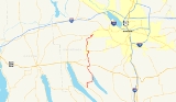
New York State Route 174 (NY 174) is a state highway
in Onondaga County
, located in Central New York
, United States
. The highway is 16.7 miles (26.9 km) long and passes through mostly rural regions. Route 174 begins at an intersection with NY 41
in Borodino
, a hamlet of Spafford
. It heads generally northward for most of its length, except for short distances in the villages of Marcellus
and Camillus
. The route ends at a junction with NY 5
west of Camillus, at the west end of the Route 5 Camillus bypass. Route 174 is located along a large mapped
sedimentary
bedrock
unit, known as the Marcellus Formation
. The formation is named for an outcrop
found near the town of Marcellus, New York
, during a geological survey
in 1839.
The road was first constructed in the early 19th century following the path of Nine Mile Creek, which connected several early settlements in Central New York. The northern half of the route, between the villages of Marcellus and Camillus, was later improved as a plank road
in 1855 by a private corporation that collected tolls from travelers on the road. The state took over the maintenance of the road by the beginning of the 20th century. The former plank road and an extension south to Otisco Lake
and southwest to Skaneateles Lake
was first designated as Route 174 in the 1930 state highway renumbering. Since then, several minor realignments have been made in the areas of the villages of Marcellus and Camillus to accommodate newly built bypasses.
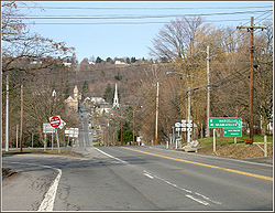
 Route 174 begins its 16 miles (26 km) route through Onondaga County at an intersection with NY 41
in the hamlet
of Borodino
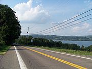
, on the shores of Skaneateles Lake
. The road heads north, passing to the east of Hardscrabble Point, to an intersection with Eibert Road (County Route 131 or CR 131) where it turns east. The highway then heads eastward for about a mile (1.6 km) to a turn along the shore of Otisco Lake
. It follows the shoreline of the lake northward into the town of Marcellus
, soon entering the hamlet of Marietta
. North of Marietta, the lake narrows into the Nine Mile Creek, which parallels Route 174 for the rest of the highway's length.
 Within the town of Marcellus, Route 174 intersects and becomes concurrent with U.S. Route 20
(US 20) for about 0.3 mile (0.482802 km) until Sevier Road. Route 174 continues north along Sevier Road, still paralleling the creek, towards the village of Marcellus
. South of the village line, NY 175
joins Route 174 and the two routes are concurrent for about 2 miles (3 km). The two roads go around the southeast border of the village, passing by the county park, then split in different directions just east of the village. Route 175 turns to the east while Route 174 turns to the west along the West Seneca Turnpike, entering the village of Marcellus.
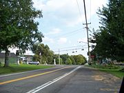
Route 174 passes through the village center then turns north along North Street and heads out of the village, turning northward through the hamlet of Marcellus Falls. After Marcellus, the land around the route becomes more developed with residential areas becoming more common. About 0.3 mile (0.482802 km) north of Marcellus, Route 174 crosses Nine Mile Creek; the bridge itself is designated as NY 174X, which is an internal designation used by NYSDOT and not signed as such.
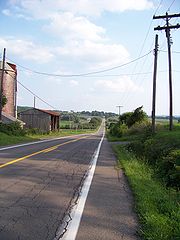
The road continues north, still paralleling the Nine Mile Creek, into the town of Camillus
. In Bennetts Corners, Route 174 intersects with Forward Road (unsigned NY 931F), a connector road to NY 321
, then changes direction to head northeast. The road passes by Nose Hill before entering the village of Camillus
. In the village center, Route 174 makes a sharp turn to the west onto West Genesee Street, where it comes to an end just west of the village line at a junction with NY 5
(where its freeway begins) that includes a jughandle
, a slip road onto the freeway. NY 174 is located along a geological feature known as a mapped
sedimentary
bedrock
unit, known as the Marcellus Formation
. The formation is named for an outcrop
found near the town of Marcellus, New York
, during a geological survey
in 1839.
 The village of Marcellus was first settled in 1794 at the intersection of two transportation routes: an old Iroquois
trail running east–west (later to become the Seneca Turnpike) and the north–south Nine Mile Creek. At the beginning of the 19th century, land travel along the Nine Mile Creek was very difficult and most travel between Marcellus and the settlements along Onondaga Lake
was by water. In 1831 the New York State Legislature authorized the construction of a road to follow Nine Mile Creek from Marcellus towards the town of Salina
at Onondaga Lake.
In 1855, the road from Marcellus to Camillus along the Nine Mile Creek route was improved by the Camillus and Marcellus Plank Road Company, which was first chartered in 1853 and authorized to collect tolls from travelers using the road. The improvement of the road led to it becoming a stagecoach route in the middle of the 19th century. The former plank road alignment in the village of Marcellus (North Street) and the southward continuation along Cherry Street (now South Street) was paved in 1911 as part of the construction of a new state highway that would pass through the town.
in Otisco
. NY 174 was truncated northwestward ca. 1932 to begin at US 20 south of Marcellus. The portion of its former routing between US 20 and NY 337 became a northward extension of NY 337. This change was short-lived as NY 337 was supplanted by an extended NY 174 by the following year. The northernmost portion of NY 174 from Forward Road to NY 5
in Camillus village
was originally designated as part of NY 26 in 1924. The route began in Ithaca
and ended in Syracuse
. The portion of NY 26 between the villages of Skaneateles
and Camillus became NY 321
as part of the 1930 renumbering, resulting in an overlap with NY 174 from Forward Road to NY 5. NY 321 has since been relocated to the west on a county road, and Forward Road is now NY 931F, an unsigned, state-maintained highway known as a reference route.
 Ca. 1938, NY 20N
was designated as a northerly alternate route
of US 20 between Skaneateles and Cazenovia
. It utilized existing numbered roads, including NY 174 from US 20 in Skaneateles north to Marcellus
, where it turned eastward to follow NY 175. The NY 20N designation was removed ca. 1962.
Route 174 has also had several minor realignments. After Route 5 was realigned onto a new expressway from Camillus to Fairmount, Route 174 was extended on its northern end to meet the west end of the bypass in Camillus. The new alignment makes a sharp hook west along the former Route 5. Route 174 has also been relocated onto a southeastern bypass around the village of Marcellus that also carries Route 175. Originally, Routes 174 and 175 entered the village along South Street. The routes were realigned to the bypass between 1976 and 1989. Route 174 now enters downtown Marcellus using several blocks of the historic Seneca Turnpike between the old and new alignments. This section of the route is maintained by Onondaga County as CR 41. The former South Street alignment has been redesignated as CR 83.
In April 2008, the New York State Senate
introduced and passed a bill to rename part of Route 174 as the "Father Joseph Champlin Memorial Highway". This would include the portion of the highway from the Camillus town line to Route 5. Also starting in 2008, the New York State Department of Transportation
began a rehabilitation project on Route 174. The Marcellus Falls bridge over Nine Mile Creek, also known as NY 174X, is closed off for a complete rehabilitation and a detour has been placed around it. Construction is reduced to one lane between Main Street and Scotch Hill Road and will continue until June 24, 2008. On November 21, 2008, the bridge was re-opened and the construction completed.
State highway
State highway, state road or state route can refer to one of three related concepts, two of them related to a state or provincial government in a country that is divided into states or provinces :#A...
in Onondaga County
Onondaga County, New York
Onondaga County is a county located in the U.S. state of New York. As of the 2010 census, the population was 467,026. The county seat is Syracuse.Onondaga County is part of the Syracuse, NY Metropolitan Statistical Area....
, located in Central New York
Central New York
Central New York is a term used to broadly describe the central region of New York State, roughly including the following counties and cities:...
, United States
United States
The United States of America is a federal constitutional republic comprising fifty states and a federal district...
. The highway is 16.7 miles (26.9 km) long and passes through mostly rural regions. Route 174 begins at an intersection with NY 41
New York State Route 41
New York State Route 41 is a north–south state highway in Central New York, United States. The southern terminus of the route is at an interchange with NY 17 in the town of Sanford. Its northern terminus is at an intersection with U.S. Route 20 in the village of Skaneateles...
in Borodino
Borodino, New York
Borodino is a hamlet located at the intersection of New York State Route 41 and New York State Route 174 in the Town of Spafford in Onondaga County, New York, near Skaneateles Lake. There is a boat launch into Skaneateles Lake for residents. There is a monument for veterans in the center of...
, a hamlet of Spafford
Spafford, New York
Spafford is a town in Onondaga County, New York, United States. The population was 1,661 at the 2000 census. The town was named after Horatio Gates Spafford, a writer and founder of the local library....
. It heads generally northward for most of its length, except for short distances in the villages of Marcellus
Marcellus (village), New York
Marcellus is a village located in the Town of Marcellus in Onondaga County, New York, USA. The population was 1,826 at the 2000 census. The Village of Marcellus is southwest of Syracuse and is in the southern part of the Town of Marcellus.-History:...
and Camillus
Camillus (village), New York
Camillus is a village in Onondaga County, New York, United States. The population was 1,249 at the 2000 census. The village takes its name from the town in which it is located...
. The route ends at a junction with NY 5
New York State Route 5
New York State Route 5 is a state highway that extends for across the state of New York in the United States. It begins at the Pennsylvania state line in the Chautauqua County town of Ripley and passes through Buffalo, Syracuse, Utica, Schenectady, and several other smaller cities and...
west of Camillus, at the west end of the Route 5 Camillus bypass. Route 174 is located along a large mapped
Geologic map
A geologic map or geological map is a special-purpose map made to show geological features. Rock units or geologic strata are shown by color or symbols to indicate where they are exposed at the surface...
sedimentary
Sedimentary rock
Sedimentary rock are types of rock that are formed by the deposition of material at the Earth's surface and within bodies of water. Sedimentation is the collective name for processes that cause mineral and/or organic particles to settle and accumulate or minerals to precipitate from a solution....
bedrock
Bedrock
In stratigraphy, bedrock is the native consolidated rock underlying the surface of a terrestrial planet, usually the Earth. Above the bedrock is usually an area of broken and weathered unconsolidated rock in the basal subsoil...
unit, known as the Marcellus Formation
Marcellus Formation
The Marcellus Formation is a unit of marine sedimentary rock found in eastern North America...
. The formation is named for an outcrop
Outcrop
An outcrop is a visible exposure of bedrock or ancient superficial deposits on the surface of the Earth. -Features:Outcrops do not cover the majority of the Earth's land surface because in most places the bedrock or superficial deposits are covered by a mantle of soil and vegetation and cannot be...
found near the town of Marcellus, New York
Marcellus (town), New York
Marcellus is a town in Onondaga County, New York, United States. The population was 6,319 at the 2000 census. The town was probably named after Marcus Claudius Marcellus, a Roman general, by a clerk interested in the Classics....
, during a geological survey
Geological survey
The term geological survey can be used to describe both the conduct of a survey for geological purposes and an institution holding geological information....
in 1839.
The road was first constructed in the early 19th century following the path of Nine Mile Creek, which connected several early settlements in Central New York. The northern half of the route, between the villages of Marcellus and Camillus, was later improved as a plank road
Plank road
A plank road or puncheon is a dirt path or road covered with a series of planks, similar to the wooden sidewalks one would see in a Western movie. Plank roads were very popular in Ontario, the U.S. Northeast and U.S. Midwest in the first half of the 19th century...
in 1855 by a private corporation that collected tolls from travelers on the road. The state took over the maintenance of the road by the beginning of the 20th century. The former plank road and an extension south to Otisco Lake
Otisco Lake
Otisco Lake is one of the minor Finger Lakes, located at the eastern end of the Finger Lake District, southwest of Syracuse, New York.Otisco Lake is approximately six miles long. The outflow enters first Onondaga Lake via Nine Mile Creek and then Lake Ontario via the Seneca and Oswego Rivers...
and southwest to Skaneateles Lake
Skaneateles Lake
Skaneateles Lake is one of the Finger Lakes in central New York in the United States. The name Skaneateles means long lake in one of the local Iroquoian languages. The lake is sometimes referred to as "The Roof Garden of the Lakes" because its altitude is higher than the other Finger Lakes. It...
was first designated as Route 174 in the 1930 state highway renumbering. Since then, several minor realignments have been made in the areas of the villages of Marcellus and Camillus to accommodate newly built bypasses.
Route description
New York State Route 41
New York State Route 41 is a north–south state highway in Central New York, United States. The southern terminus of the route is at an interchange with NY 17 in the town of Sanford. Its northern terminus is at an intersection with U.S. Route 20 in the village of Skaneateles...
in the hamlet
Hamlet (place)
A hamlet is usually a rural settlement which is too small to be considered a village, though sometimes the word is used for a different sort of community. Historically, when a hamlet became large enough to justify building a church, it was then classified as a village...
of Borodino
Borodino, New York
Borodino is a hamlet located at the intersection of New York State Route 41 and New York State Route 174 in the Town of Spafford in Onondaga County, New York, near Skaneateles Lake. There is a boat launch into Skaneateles Lake for residents. There is a monument for veterans in the center of...
, on the shores of Skaneateles Lake
Skaneateles Lake
Skaneateles Lake is one of the Finger Lakes in central New York in the United States. The name Skaneateles means long lake in one of the local Iroquoian languages. The lake is sometimes referred to as "The Roof Garden of the Lakes" because its altitude is higher than the other Finger Lakes. It...
. The road heads north, passing to the east of Hardscrabble Point, to an intersection with Eibert Road (County Route 131 or CR 131) where it turns east. The highway then heads eastward for about a mile (1.6 km) to a turn along the shore of Otisco Lake
Otisco Lake
Otisco Lake is one of the minor Finger Lakes, located at the eastern end of the Finger Lake District, southwest of Syracuse, New York.Otisco Lake is approximately six miles long. The outflow enters first Onondaga Lake via Nine Mile Creek and then Lake Ontario via the Seneca and Oswego Rivers...
. It follows the shoreline of the lake northward into the town of Marcellus
Marcellus (town), New York
Marcellus is a town in Onondaga County, New York, United States. The population was 6,319 at the 2000 census. The town was probably named after Marcus Claudius Marcellus, a Roman general, by a clerk interested in the Classics....
, soon entering the hamlet of Marietta
Marietta, New York
Marietta is a hamlet in Onondaga County, New York, United States. Marietta is southwest of Syracuse....
. North of Marietta, the lake narrows into the Nine Mile Creek, which parallels Route 174 for the rest of the highway's length.
U.S. Route 20 in New York
U.S. Route 20 is a part of the U.S. Highway System that runs from Newport, Oregon, to Boston, Massachusetts. In the U.S. state of New York, US 20 extends from the Pennsylvania state line at Ripley to the Massachusetts state line in the Berkshire Mountains. US 20 is the longest...
(US 20) for about 0.3 mile (0.482802 km) until Sevier Road. Route 174 continues north along Sevier Road, still paralleling the creek, towards the village of Marcellus
Marcellus (village), New York
Marcellus is a village located in the Town of Marcellus in Onondaga County, New York, USA. The population was 1,826 at the 2000 census. The Village of Marcellus is southwest of Syracuse and is in the southern part of the Town of Marcellus.-History:...
. South of the village line, NY 175
New York State Route 175
New York State Route 175 is a west–east state highway located in Onondaga County, New York, in the United States. The route begins at an intersection with U.S. Route 20 east of the village of Skaneateles and passes through the village of Marcellus before ending at a junction with...
joins Route 174 and the two routes are concurrent for about 2 miles (3 km). The two roads go around the southeast border of the village, passing by the county park, then split in different directions just east of the village. Route 175 turns to the east while Route 174 turns to the west along the West Seneca Turnpike, entering the village of Marcellus.
Route 174 passes through the village center then turns north along North Street and heads out of the village, turning northward through the hamlet of Marcellus Falls. After Marcellus, the land around the route becomes more developed with residential areas becoming more common. About 0.3 mile (0.482802 km) north of Marcellus, Route 174 crosses Nine Mile Creek; the bridge itself is designated as NY 174X, which is an internal designation used by NYSDOT and not signed as such.
The road continues north, still paralleling the Nine Mile Creek, into the town of Camillus
Camillus (town), New York
Camillus is a town in Onondaga County, New York, U.S. The population was 24,167 at the 2010 census. The town was named after Roman military leader Marcus Furius Camillus by a clerk interested in the classics....
. In Bennetts Corners, Route 174 intersects with Forward Road (unsigned NY 931F), a connector road to NY 321
New York State Route 321
New York State Route 321 is a state highway in Onondaga County, New York, United States. The southern terminus of the route is at an intersection with U.S. Route 20 in the village of Skaneateles. Its northern terminus is at an intersection with NY 5 in Bennetts Corners, a hamlet...
, then changes direction to head northeast. The road passes by Nose Hill before entering the village of Camillus
Camillus (village), New York
Camillus is a village in Onondaga County, New York, United States. The population was 1,249 at the 2000 census. The village takes its name from the town in which it is located...
. In the village center, Route 174 makes a sharp turn to the west onto West Genesee Street, where it comes to an end just west of the village line at a junction with NY 5
New York State Route 5
New York State Route 5 is a state highway that extends for across the state of New York in the United States. It begins at the Pennsylvania state line in the Chautauqua County town of Ripley and passes through Buffalo, Syracuse, Utica, Schenectady, and several other smaller cities and...
(where its freeway begins) that includes a jughandle
Jughandle
A jughandle is a type of ramp or slip road that changes the way traffic turns left at at-grade intersections. Instead of a standard left turn being made from the left lane, left-turning traffic uses a ramp on the right side of the road...
, a slip road onto the freeway. NY 174 is located along a geological feature known as a mapped
Geologic map
A geologic map or geological map is a special-purpose map made to show geological features. Rock units or geologic strata are shown by color or symbols to indicate where they are exposed at the surface...
sedimentary
Sedimentary rock
Sedimentary rock are types of rock that are formed by the deposition of material at the Earth's surface and within bodies of water. Sedimentation is the collective name for processes that cause mineral and/or organic particles to settle and accumulate or minerals to precipitate from a solution....
bedrock
Bedrock
In stratigraphy, bedrock is the native consolidated rock underlying the surface of a terrestrial planet, usually the Earth. Above the bedrock is usually an area of broken and weathered unconsolidated rock in the basal subsoil...
unit, known as the Marcellus Formation
Marcellus Formation
The Marcellus Formation is a unit of marine sedimentary rock found in eastern North America...
. The formation is named for an outcrop
Outcrop
An outcrop is a visible exposure of bedrock or ancient superficial deposits on the surface of the Earth. -Features:Outcrops do not cover the majority of the Earth's land surface because in most places the bedrock or superficial deposits are covered by a mantle of soil and vegetation and cannot be...
found near the town of Marcellus, New York
Marcellus (town), New York
Marcellus is a town in Onondaga County, New York, United States. The population was 6,319 at the 2000 census. The town was probably named after Marcus Claudius Marcellus, a Roman general, by a clerk interested in the Classics....
, during a geological survey
Geological survey
The term geological survey can be used to describe both the conduct of a survey for geological purposes and an institution holding geological information....
in 1839.
Old roads
Iroquois
The Iroquois , also known as the Haudenosaunee or the "People of the Longhouse", are an association of several tribes of indigenous people of North America...
trail running east–west (later to become the Seneca Turnpike) and the north–south Nine Mile Creek. At the beginning of the 19th century, land travel along the Nine Mile Creek was very difficult and most travel between Marcellus and the settlements along Onondaga Lake
Onondaga Lake
Onondaga Lake is a lake in Central New York located northwest of Syracuse, New York. The southeastern end of the lake and the southwestern shore abut industrial areas and expressways; the northeastern shore and northwestern end border a series of parks and museums. Although it is near the Finger...
was by water. In 1831 the New York State Legislature authorized the construction of a road to follow Nine Mile Creek from Marcellus towards the town of Salina
Salina, New York
Salina is a town in Onondaga County, New York, United States. The population was 33,290 at the 2000 census. The name of the town is derived from the Latin word for "salt."...
at Onondaga Lake.
In 1855, the road from Marcellus to Camillus along the Nine Mile Creek route was improved by the Camillus and Marcellus Plank Road Company, which was first chartered in 1853 and authorized to collect tolls from travelers using the road. The improvement of the road led to it becoming a stagecoach route in the middle of the 19th century. The former plank road alignment in the village of Marcellus (North Street) and the southward continuation along Cherry Street (now South Street) was paved in 1911 as part of the construction of a new state highway that would pass through the town.
Designation
The route from Marcellus (at US 20) to Camillus was designated as Route 174 in the 1930 renumbering of state highways in New York. At the time, the segment of modern NY 174 from Otisco Valley Road (south of US 20) to Borodino was designated as NY 337 while NY 174 followed Otisco Valley and Oak Hill Roads southeast to an intersection with NY 80New York State Route 80
New York State Route 80 is a west–east New York State Route located within Onondaga, Madison, Chenango, Otsego, Herkimer, and Montgomery Counties in New York. Its western terminus is located at a junction with NY 175 in the city of Syracuse in Onondaga County, from which it...
in Otisco
Otisco, New York
Otisco is a town in Onondaga County, New York, United States. The population was 2,561 at the 2000 census. The Town of Otisco is in the southwest part of the county. Otisco is situated at the northern edge of the Appalacian Highlands, where an escarpment declines to the Lake Ontario plain and the...
. NY 174 was truncated northwestward ca. 1932 to begin at US 20 south of Marcellus. The portion of its former routing between US 20 and NY 337 became a northward extension of NY 337. This change was short-lived as NY 337 was supplanted by an extended NY 174 by the following year. The northernmost portion of NY 174 from Forward Road to NY 5
New York State Route 5
New York State Route 5 is a state highway that extends for across the state of New York in the United States. It begins at the Pennsylvania state line in the Chautauqua County town of Ripley and passes through Buffalo, Syracuse, Utica, Schenectady, and several other smaller cities and...
in Camillus village
Camillus (village), New York
Camillus is a village in Onondaga County, New York, United States. The population was 1,249 at the 2000 census. The village takes its name from the town in which it is located...
was originally designated as part of NY 26 in 1924. The route began in Ithaca
Ithaca, New York
The city of Ithaca, is a city in upstate New York and the county seat of Tompkins County, as well as the largest community in the Ithaca-Tompkins County metropolitan area...
and ended in Syracuse
Syracuse, New York
Syracuse is a city in and the county seat of Onondaga County, New York, United States, the largest U.S. city with the name "Syracuse", and the fifth most populous city in the state. At the 2010 census, the city population was 145,170, and its metropolitan area had a population of 742,603...
. The portion of NY 26 between the villages of Skaneateles
Skaneateles (village), New York
Skaneateles is a village in the town of Skaneateles, Onondaga County, New York, United States. The village is named from and located on the shores of Skaneateles Lake, one of the Finger Lakes. The village, as of the 2000 census, has a population of 2,616 residents. The main highway through the...
and Camillus became NY 321
New York State Route 321
New York State Route 321 is a state highway in Onondaga County, New York, United States. The southern terminus of the route is at an intersection with U.S. Route 20 in the village of Skaneateles. Its northern terminus is at an intersection with NY 5 in Bennetts Corners, a hamlet...
as part of the 1930 renumbering, resulting in an overlap with NY 174 from Forward Road to NY 5. NY 321 has since been relocated to the west on a county road, and Forward Road is now NY 931F, an unsigned, state-maintained highway known as a reference route.
New York State Route 20N
New York State Route 20N was a state highway in Central New York, United States. It was an alternate route of U.S. Route 20 that stretched for between Marcellus and Cazenovia. The road began at its parent route, US 20, and NY 174 in Marcellus and ended at US 20,...
was designated as a northerly alternate route
Alternate route
An official alternate route is a special route in the United States that provides an alternate alignment for a highway. They are loop roads and found in many road systems in the United States including the U.S. Route system and various state route systems...
of US 20 between Skaneateles and Cazenovia
Cazenovia (village), New York
Cazenovia is a village located in the Town of Cazenovia in Madison County, New York, United States. As of the 2000 census, the village had a population of 2,614. The village lies on the southeast shore of Cazenovia Lake, which is approximately long and .5 miles across...
. It utilized existing numbered roads, including NY 174 from US 20 in Skaneateles north to Marcellus
Marcellus (village), New York
Marcellus is a village located in the Town of Marcellus in Onondaga County, New York, USA. The population was 1,826 at the 2000 census. The Village of Marcellus is southwest of Syracuse and is in the southern part of the Town of Marcellus.-History:...
, where it turned eastward to follow NY 175. The NY 20N designation was removed ca. 1962.
Route 174 has also had several minor realignments. After Route 5 was realigned onto a new expressway from Camillus to Fairmount, Route 174 was extended on its northern end to meet the west end of the bypass in Camillus. The new alignment makes a sharp hook west along the former Route 5. Route 174 has also been relocated onto a southeastern bypass around the village of Marcellus that also carries Route 175. Originally, Routes 174 and 175 entered the village along South Street. The routes were realigned to the bypass between 1976 and 1989. Route 174 now enters downtown Marcellus using several blocks of the historic Seneca Turnpike between the old and new alignments. This section of the route is maintained by Onondaga County as CR 41. The former South Street alignment has been redesignated as CR 83.
In April 2008, the New York State Senate
New York State Senate
The New York State Senate is one of two houses in the New York State Legislature and has members each elected to two-year terms. There are no limits on the number of terms one may serve...
introduced and passed a bill to rename part of Route 174 as the "Father Joseph Champlin Memorial Highway". This would include the portion of the highway from the Camillus town line to Route 5. Also starting in 2008, the New York State Department of Transportation
New York State Department of Transportation
The New York State Department of Transportation is responsible for the development and operation of highways, railroads, mass transit systems, ports, waterways and aviation facilities in the U.S...
began a rehabilitation project on Route 174. The Marcellus Falls bridge over Nine Mile Creek, also known as NY 174X, is closed off for a complete rehabilitation and a detour has been placed around it. Construction is reduced to one lane between Main Street and Scotch Hill Road and will continue until June 24, 2008. On November 21, 2008, the bridge was re-opened and the construction completed.
Major intersections