
Otisco, New York
Encyclopedia
Otisco is a town in Onondaga County
, New York
, United States
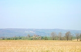
. The population was 2,561 at the 2000 census. The Town of Otisco is in the southwest part of the county. Otisco is situated at the northern edge of the Appalacian Highlands, where an escarpment declines to the Lake Ontario plain and the City of Syracuse
five miles to the north. Extremely hilly terrain affords a sense of spatial grandeur and magnificent views.
. The town was first settled by outsiders around 1798, but permanent settlement began around 1801. The Town of Otisco was formed in 1806 from parts of other towns: Pompey
, Marcellus
, and Tully
. The name, "Otisco," derives from the Native American (Iroquois
), Us-te-ke, meaning "bitter-nut-hickory." The name "Otisco" appeared on an 1825 map. The same Iroquois name referred to Nine Mile Creek. This and alternate suggestions about the origin of the name appear in the Beauchamp article, cited below.
, the town has a total area of 31.2 square miles (80.8 km²), of which, 29.6 square miles (76.7 km²) of it is land and 1.5 square miles (3.9 km²) of it (4.94%) is water.
Otisco is in the Finger Lakes
District of New York and borders Otisco Lake
.
New York State Route 80
is a north-south highway in the town. A short part of US Route 20 crosses the northeast corner of the town.
of 2000, there were 2,561 people, 922 households, and 693 families residing in the town. The population density
was 86.4 people per square mile (33.4/km²). There were 1,200 housing units at an average density of 40.5 per square mile (15.6/km²). The racial makeup of the town was 97.27% White, 0.23% African American, 0.31% Native American, 0.62% Asian, 0.16% from other races
, and 1.41% from two or more races. Hispanic or Latino of any race were 0.47% of the population.
There were 922 households out of which 42.2% had children under the age of 18 living with them, 61.4% were married couples
living together, 8.2% had a female householder with no husband present, and 24.8% were non-families. 18.9% of all households were made up of individuals and 6.3% had someone living alone who was 65 years of age or older. The average household size was 2.78 and the average family size was 3.22.
In the town the population was spread out with 31.2% under the age of 18, 6.4% from 18 to 24, 31.0% from 25 to 44, 21.8% from 45 to 64, and 9.6% who were 65 years of age or older. The median age was 36 years. For every 100 females there were 103.6 males. For every 100 females age 18 and over, there were 102.8 males.
The median income for a household in the town was $44,643, and the median income for a family was $49,318. Males had a median income of $39,656 versus $26,463 for females. The per capita income
for the town was $19,726. About 3.2% of families and 5.7% of the population were below the poverty line, including 8.3% of those under age 18 and 1.6% of those age 65 or over.
Onondaga County, New York
Onondaga County is a county located in the U.S. state of New York. As of the 2010 census, the population was 467,026. The county seat is Syracuse.Onondaga County is part of the Syracuse, NY Metropolitan Statistical Area....
, New York
New York
New York is a state in the Northeastern region of the United States. It is the nation's third most populous state. New York is bordered by New Jersey and Pennsylvania to the south, and by Connecticut, Massachusetts and Vermont to the east...
, United States
United States
The United States of America is a federal constitutional republic comprising fifty states and a federal district...
. The population was 2,561 at the 2000 census. The Town of Otisco is in the southwest part of the county. Otisco is situated at the northern edge of the Appalacian Highlands, where an escarpment declines to the Lake Ontario plain and the City of Syracuse
Syracuse, New York
Syracuse is a city in and the county seat of Onondaga County, New York, United States, the largest U.S. city with the name "Syracuse", and the fifth most populous city in the state. At the 2010 census, the city population was 145,170, and its metropolitan area had a population of 742,603...
five miles to the north. Extremely hilly terrain affords a sense of spatial grandeur and magnificent views.
History
The town was part of the former Central New York Military TractCentral New York Military Tract
The Military Tract of Central New York, also called the New Military Tract, consisted of nearly two million acres of bounty land set aside to compensate New York’s soldiers after their participation in the Revolutionary War....
. The town was first settled by outsiders around 1798, but permanent settlement began around 1801. The Town of Otisco was formed in 1806 from parts of other towns: Pompey
Pompey, New York
Pompey is a town in the southeast part of Onondaga County, New York, United States. The population was 6,159 at the 2000 census. The town was named after the Roman general and political leader Pompey by a late 18th-century clerk interested in the Classics in the new federal republic.- History :The...
, Marcellus
Marcellus (town), New York
Marcellus is a town in Onondaga County, New York, United States. The population was 6,319 at the 2000 census. The town was probably named after Marcus Claudius Marcellus, a Roman general, by a clerk interested in the Classics....
, and Tully
Tully (town), New York
Tully is a town in Onondaga County, New York, USA. The population of the town was 2,709 at the 2000 census. The name of the town is derived from the Roman orator Marcus Tullius Cicero. The town is on the county's south border, south of Syracuse....
. The name, "Otisco," derives from the Native American (Iroquois
Iroquois
The Iroquois , also known as the Haudenosaunee or the "People of the Longhouse", are an association of several tribes of indigenous people of North America...
), Us-te-ke, meaning "bitter-nut-hickory." The name "Otisco" appeared on an 1825 map. The same Iroquois name referred to Nine Mile Creek. This and alternate suggestions about the origin of the name appear in the Beauchamp article, cited below.
Geography
According to the United States Census BureauUnited States Census Bureau
The United States Census Bureau is the government agency that is responsible for the United States Census. It also gathers other national demographic and economic data...
, the town has a total area of 31.2 square miles (80.8 km²), of which, 29.6 square miles (76.7 km²) of it is land and 1.5 square miles (3.9 km²) of it (4.94%) is water.
Otisco is in the Finger Lakes
Finger Lakes
The Finger Lakes are a pattern of lakes in the west-central section of Upstate New York in the United States. They are a popular tourist destination. The lakes are long and thin , each oriented roughly on a north-south axis. The two longest, Cayuga Lake and Seneca Lake, are among the deepest in...
District of New York and borders Otisco Lake
Otisco Lake
Otisco Lake is one of the minor Finger Lakes, located at the eastern end of the Finger Lake District, southwest of Syracuse, New York.Otisco Lake is approximately six miles long. The outflow enters first Onondaga Lake via Nine Mile Creek and then Lake Ontario via the Seneca and Oswego Rivers...
.
New York State Route 80
New York State Route 80
New York State Route 80 is a west–east New York State Route located within Onondaga, Madison, Chenango, Otsego, Herkimer, and Montgomery Counties in New York. Its western terminus is located at a junction with NY 175 in the city of Syracuse in Onondaga County, from which it...
is a north-south highway in the town. A short part of US Route 20 crosses the northeast corner of the town.
Demographics
As of the censusCensus
A census is the procedure of systematically acquiring and recording information about the members of a given population. It is a regularly occurring and official count of a particular population. The term is used mostly in connection with national population and housing censuses; other common...
of 2000, there were 2,561 people, 922 households, and 693 families residing in the town. The population density
Population density
Population density is a measurement of population per unit area or unit volume. It is frequently applied to living organisms, and particularly to humans...
was 86.4 people per square mile (33.4/km²). There were 1,200 housing units at an average density of 40.5 per square mile (15.6/km²). The racial makeup of the town was 97.27% White, 0.23% African American, 0.31% Native American, 0.62% Asian, 0.16% from other races
Race (United States Census)
Race and ethnicity in the United States Census, as defined by the Federal Office of Management and Budget and the United States Census Bureau, are self-identification data items in which residents choose the race or races with which they most closely identify, and indicate whether or not they are...
, and 1.41% from two or more races. Hispanic or Latino of any race were 0.47% of the population.
There were 922 households out of which 42.2% had children under the age of 18 living with them, 61.4% were married couples
Marriage
Marriage is a social union or legal contract between people that creates kinship. It is an institution in which interpersonal relationships, usually intimate and sexual, are acknowledged in a variety of ways, depending on the culture or subculture in which it is found...
living together, 8.2% had a female householder with no husband present, and 24.8% were non-families. 18.9% of all households were made up of individuals and 6.3% had someone living alone who was 65 years of age or older. The average household size was 2.78 and the average family size was 3.22.
In the town the population was spread out with 31.2% under the age of 18, 6.4% from 18 to 24, 31.0% from 25 to 44, 21.8% from 45 to 64, and 9.6% who were 65 years of age or older. The median age was 36 years. For every 100 females there were 103.6 males. For every 100 females age 18 and over, there were 102.8 males.
The median income for a household in the town was $44,643, and the median income for a family was $49,318. Males had a median income of $39,656 versus $26,463 for females. The per capita income
Per capita income
Per capita income or income per person is a measure of mean income within an economic aggregate, such as a country or city. It is calculated by taking a measure of all sources of income in the aggregate and dividing it by the total population...
for the town was $19,726. About 3.2% of families and 5.7% of the population were below the poverty line, including 8.3% of those under age 18 and 1.6% of those age 65 or over.
Communities and locations in Otisco
- Amber – A hamlet in the northwest part of Otisco by Otisco Lake.
- Amber Brook – A streamStreamA stream is a body of water with a current, confined within a bed and stream banks. Depending on its locale or certain characteristics, a stream may be referred to as a branch, brook, beck, burn, creek, "crick", gill , kill, lick, rill, river, syke, bayou, rivulet, streamage, wash, run or...
flowing into Otisco Lake by Amber. - Bay Shores – A lakeside hamlet north of Rice Grove.
- Bear Mountain (the blue hole) – An elevation in the northeast once known for the number of bearBearBears are mammals of the family Ursidae. Bears are classified as caniforms, or doglike carnivorans, with the pinnipeds being their closest living relatives. Although there are only eight living species of bear, they are widespread, appearing in a wide variety of habitats throughout the Northern...
s; the blue hole is a water hole on the mountain that is known for its swift current and waterfalls . - Case – A location in the northeast part of Otisco, south of Maple Grove.
- Gamble Mill – A hamlet between Otisco hamlet and Rice Grove.
- Heath Grove – A location south of Amber.
- Maple Grove – A hamlet in the northeast part of Otisco.
- Otisco – The hamlet of Otisco.
- Otisco Valley – A hamlet near the town line in the southwest part of Otisco.
- Rice Grove – A hamlet in the southwest part of the town, on Otisco Lake, west of Otisco hamlet.
- Williams Grove – A lakeshore hamlet south of Rice Grove.