
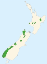
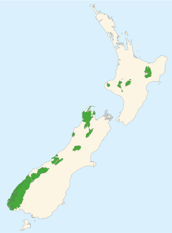
National parks of New Zealand
Encyclopedia
Tongariro National Park
Tongariro National Park is the oldest national park in New Zealand, located in the central North Island. It has been acknowledged by UNESCO as one of the 28 mixed cultural and natural World Heritage Sites....
, in particular, is one of 27 World Heritage Sites that is of both cultural and natural significance, while four of the South Island
South Island
The South Island is the larger of the two major islands of New Zealand, the other being the more populous North Island. It is bordered to the north by Cook Strait, to the west by the Tasman Sea, to the south and east by the Pacific Ocean...
national parks form Te Wahipounamu
Te Wahipounamu
Te Wāhipounamu is a World Heritage site in the south west corner of the South Island of New Zealand.Inscribed on the World Heritage List in 1990 and covering 26,000 km², the site incorporates several National Parks:...
, another World Heritage Site.
National Parks Act
The National Parks Act of 1980 was established in order to codify the purpose, governance and selection of national parks. It begins by establishing the definition of a national park:The National Parks Act goes on to state that the public will have freedom of entry and access to the parks, though this is subject to restrictions to ensure the preservation of native plants and animals and the welfare of the parks in general. Access to specially protected areas (550 km²) constituted under the act is by permit only.
Under the Act, national parks are to be maintained in their natural state as far as possible to retain their value as soil, water and forest conservation areas. Native plants and animals are to be preserved and introduced plants and animals removed if their presence interferes with the natural wildlife. Development in wilderness areas established under the act is restricted to foot tracks and huts used for wild animal control or scientific research.
Services available for public use
The Act allows the Department of Conservation to provide hostels, huts, camping grounds, ski tows and similar facilities, parking areas, roading and tracks within the parks. In addition to these, the department also provides some accommodation, transport and other services at entry points to the parks, but these are also offered by other government agencies, voluntary organisations and private firms. More comprehensive services within the parks, such as guided walks and skiing tutorials, are privately provided with concessions from the department.List of national parks
| National Park | Area | Established | Location | Te Urewera National Park Te Urewera National Park Te Urewera National Park is one of fourteen national parks within New Zealand and is the largest of the four in the North Island. Covering an area of approximately 2,127 km², it is in the north east of the Hawke's Bay region of the North Island.... | 2,127 km² | 1954 | 38°45′"S 117°9′"E | Together with neighbouring Whirinaki Forest Park Whirinaki Forest Park Whirinaki Forest Park is a publicly accessible forest park in the North Island of New Zealand. The park is centered around the town of Minginui and part of the eastern boundary flanks the Urewera National Park.... , Te Urewera is the largest remaining stand of native forest in the North Island North Island The North Island is one of the two main islands of New Zealand, separated from the much less populous South Island by Cook Strait. The island is in area, making it the world's 14th-largest island... . Lake Waikaremoana Lake Waikaremoana Lake Waikaremoana is located in Te Urewera National Park in the North Island of New Zealand, 60 kilometres northwest of Wairoa and 80 kilometres southwest of Gisborne. It covers an area of 54 km². From the Maori Waikaremoana translates as 'sea of rippling waters'The lake lies in the heart of Tuhoe... , within the park, is noted for its scenic shoreline. |
|---|---|---|---|---|---|---|---|---|
| Tongariro National Park Tongariro National Park Tongariro National Park is the oldest national park in New Zealand, located in the central North Island. It has been acknowledged by UNESCO as one of the 28 mixed cultural and natural World Heritage Sites.... * |
796 km² | 1887 | 39°12′"S 175°35′"E | New Zealand's first national park, recognised as one of the 27 World Heritage Sites that are of both outstanding natural and cultural value. Gifted to the Crown by Te Heuheu Tūkino IV Te Heuheu Tukino IV Te Heuheu Tukino IV was paramount chief of the Ngāti Tuwharetoa, a Māori tribe of the central North Island of New Zealand. His birth name was Pataatai but he assumed the name Horonuku - meaning landslide - after the death of his parents in a landslide in 1846... , the park includes several sacred Māori Maori mythology Māori mythology and Māori traditions are the two major categories into which the legends of the Māori of New Zealand may usefully be divided... sites and three active volcano Volcano 2. Bedrock3. Conduit 4. Base5. Sill6. Dike7. Layers of ash emitted by the volcano8. Flank| 9. Layers of lava emitted by the volcano10. Throat11. Parasitic cone12. Lava flow13. Vent14. Crater15... es, Ruapehu Mount Ruapehu Mount Ruapehu, or just Ruapehu, is an active stratovolcano at the southern end of the Taupo Volcanic Zone in New Zealand. It is 23 kilometres northeast of Ohakune and 40 kilometres southwest of the southern shore of Lake Taupo, within Tongariro National Park... , Ngauruhoe and Tongariro. |
||||
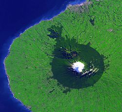
| Egmont National Park Egmont National Park Egmont National Park is located south of New Plymouth, close to the west coast of the North Island of New Zealand. It is named after the mountain which dominates its environs, which itself was named by Captain Cook after John Perceval, 2nd Earl of Egmont, the First Lord of the Admiralty who... |
335 km² | 1900 | 39°16′"S 174°6′"E | This park comprises the land about a nine-kilometre radius of Mount Taranaki/Egmont Mount Taranaki Mount Taranaki, or Mount Egmont, is an active but quiescent stratovolcano in the Taranaki region on the west coast of New Zealand's North Island. Although the mountain is more commonly referred to as Taranaki, it has two official names under the alternative names policy of the New Zealand... and some outlying areas to the north. The symmetrical cone of the dormant volcano is a provincial landmark. |
||||
| Whanganui National Park Whanganui National Park The Whanganui National Park is a national park located in the North Island of New Zealand. Established in 1986, it covers an area of 742 km² bordering the Whanganui River. It incorporates areas of Crown land, former state forest and a number of former reserves. The river itself is not part of the... |
742 km² | 1986 | 39°35′"S 175°5′"E | Bordering the Whanganui River Whanganui River The Whanganui River is a major river in the North Island of New Zealand.Known for many years as the Wanganui River, the river's name reverted to Whanganui in 1991, according with the wishes of local iwi. Part of the reason was also to avoid confusion with the Wanganui River in the South Island... , it incorporates areas of Crown land, former state forest and a number of former reserves. |
||||
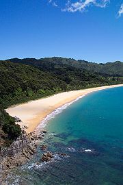
| Abel Tasman National Park Abel Tasman National Park Abel Tasman National Park is a national park located at the north end of the South Island of New Zealand. The park was founded in 1942, largely through the efforts of ornithologist and author Perrine Moncrieff to have land reserved for the purpose. With a coverage of only 225.3 square kilometres,... |
225 km² | 1942 | 40°50′"S 172°54′"E | The smallest national park, this popular tourist destination has numerous tidal inlets and beaches of golden sand along the shores of Tasman Bay Tasman Bay Tasman Bay is a large V-shaped bay at the north end of New Zealand's South Island. Located in the centre of the island's northern coast, it stretches along of coastline and is across at its widest point. It is an arm of the Tasman Sea, lying on the western approach to Cook Strait.At the bay's... . "Doing the Abel Tasman" as a tramping or kayaking Kayaking Kayaking is the use of a kayak for moving across water. Kayaking and canoeing are also known as paddling. Kayaking is distinguished from canoeing by the sitting position of the paddler and the number of blades on the paddle... journey is a popular activity. |
||||
| Kahurangi National Park Kahurangi National Park Kahurangi National Park is a national park in the northwest of the South Island of New Zealand. It was gazetted in 1996 and covers 4,520 km². It is the second largest of New Zealand's fourteen national parks... |
4,520 km² | 1996 | 41°15′"S 172°7′"E | Situated in the north-west of the South Island South Island The South Island is the larger of the two major islands of New Zealand, the other being the more populous North Island. It is bordered to the north by Cook Strait, to the west by the Tasman Sea, to the south and east by the Pacific Ocean... , Kahurangi contains spectacular and remote country, including the well-used Heaphy Track. Ancient landforms and unique flora and fauna add to the value of New Zealand's second largest national park. |
||||
| Nelson Lakes National Park Nelson Lakes National Park Nelson Lakes National Park is located in the South Island of New Zealand.It was formed in 1956 and covers some 1,020 km². It is centered at two large lakes, Rotoiti and Rotoroa. The park also includes surrounding valleys and mountain ranges... |
1,018 km² | 1956 | 41°49′9"S 172°50′15"E | A rugged, mountainous area in Nelson Region. It extends southwards from the forested shores of Lake Rotoiti and Rotoroa to the Lewis Pass National Reserve. | ||||
| Paparoa National Park Paparoa National Park Paparoa National Park is on the west coast of the South Island of New Zealand.It was established in 1987 and encompasses 306 km². The park ranges from on or near the coastline to the peak of the Paparoa Ranges. A separate section of the park is to the north and is centered at Ananui Creek.The... |
306 km² | 1987 | 42°5′"S 171°30′"E | On the West Coast of the South Island between Westport Westport, New Zealand -Economy:Economic activity is based around fishing, coal mining and dairy farming. Historically, gold mining was a major industry, and coal mining was much more extensive than today . However, the region still is home to New Zealand's largest opencast mining operation in Stockton... and Greymouth Greymouth Greymouth is the largest town in the West Coast region in the South Island of New Zealand, and the seat of the Grey District Council. The population of the whole Grey District is , which accounts for % of the West Coast's inhabitants... . It includes the celebrated Pancake Rocks at Punakaiki Punakaiki Punakaiki is a small community on the West Coast of the South Island of New Zealand, between Westport and Greymouth. The community lies on the edge of the Paparoa National Park.... . |
||||
| Arthur's Pass National Park Arthur's Pass National Park Arthur's Pass National Park is located in the South Island of New Zealand.It was established in 1929, becoming the first national park in the South Island and the third in New Zealand. It is bisected by State Highway 73. The road passes through Arthur's Pass village and the mountain pass with the... |
1,144 km² | 1929 | 42°57′"S 171°34′"E | A rugged and mountainous area straddling the main divide of the Southern Alps Southern Alps The Southern Alps is a mountain range extending along much of the length of New Zealand's South Island, reaching its greatest elevations near the island's western side... . |
||||
| Westland Tai Poutini National Park* | 1,175 km² | 1960 | 43°23′"S 170°11′"E | Extends from the highest peaks of the Southern Alps to a wild remote coastline. Included in the park are glacier Glacier A glacier is a large persistent body of ice that forms where the accumulation of snow exceeds its ablation over many years, often centuries. At least 0.1 km² in area and 50 m thick, but often much larger, a glacier slowly deforms and flows due to stresses induced by its weight... s, scenic lakes and dense rainforest Rainforest Rainforests are forests characterized by high rainfall, with definitions based on a minimum normal annual rainfall of 1750-2000 mm... , as well as remains of old gold mining Gold mining Gold mining is the removal of gold from the ground. There are several techniques and processes by which gold may be extracted from the earth.-History:... towns along the coast. |
||||
| Aoraki/Mount Cook National Park Aoraki/Mount Cook National Park Aoraki/Mount Cook National Park is in the South Island of New Zealand near the town of Twizel. Aoraki/Mount Cook, New Zealand's highest mountain and Aoraki/Mount Cook village lie within the park... * |
707 km² | 1953 | 43°44′"S 170°6′"E | An alpine park, containing New Zealand's highest mountain, Aoraki/Mount Cook Aoraki/Mount Cook Aoraki / Mount Cook is the highest mountain in New Zealand, reaching .It lies in the Southern Alps, the mountain range which runs the length of the South Island. A popular tourist destination, it is also a favourite challenge for mountain climbers... (3,754 m) and its longest glacier, Tasman Glacier Tasman Glacier The Tasman Glacier is the largest of several glaciers which flow south and east towards the Mackenzie Basin from the Southern Alps in New Zealand's South Island. It is New Zealand's longest glacier.-Geography:... (29 km). A hotspot for mountaineering Mountaineering Mountaineering or mountain climbing is the sport, hobby or profession of hiking, skiing, and climbing mountains. While mountaineering began as attempts to reach the highest point of unclimbed mountains it has branched into specialisations that address different aspects of the mountain and consists... , ski touring Ski touring Ski touring is a form of backcountry skiing involving traveling over the winter landscape on skis under human power rather than through the assistance of ski lifts or snow vehicles. It can take place in terrain ranging from perfectly flat to extremely steep... and scenic flights, the park is an area of outstanding natural beauty. |
||||
| Mount Aspiring National Park Mount Aspiring National Park Mount Aspiring National Park is located in the Southern Alps of the South Island of New Zealand, north of Fiordland National Park, and between Otago and south Westland. The park forms part of the Te Wahipounamu World Heritage site.-Geography:... * |
3,555 km² | 1964 | 44°23′"S 168°44′"E | A complex of impressively glaciated mountain scenery centred on Mount Aspiring/Tititea (3,036 m), New Zealand's highest peak outside of the main divide. | ||||
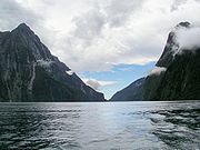
| Fiordland National Park Fiordland National Park Fiordland National Park occupies the southwest corner of the South Island of New Zealand. It is the largest of the 14 national parks in New Zealand, with an area of 12,500 km², and a major part of the Te Wahipounamu World Heritage site... * |
12,519 km² | 1952 | 45°25′"S 167°43′"E | The largest national park in New Zealand and one of the largest in the world, the park covers the southwest corner of the South Island. The grandeur of its scenery, with its deep fiords, its glacial lakes, its mountains and waterfall Waterfall A waterfall is a place where flowing water rapidly drops in elevation as it flows over a steep region or a cliff.-Formation:Waterfalls are commonly formed when a river is young. At these times the channel is often narrow and deep. When the river courses over resistant bedrock, erosion happens... s, make it a popular tourist destination. |
||||
| Rakiura National Park Rakiura National Park Rakiura National Park is a nature reserve park located on Stewart Island/Rakiura, New Zealand. It is the 14th of New Zealand's national parks and was officially opened on 9 March 2002. It covers 1,570 km², which is about 85% of Stewart Island, New Zealand's third-largest island... |
1,500 km² | 2002 | 46°54′"S 168°7′"E | Covering about 85% of Stewart Island/Rakiura Stewart Island/Rakiura Stewart Island/Rakiura is the third-largest island of New Zealand. It lies south of the South Island, across Foveaux Strait. Its permanent population is slightly over 400 people, most of whom live in the settlement of Oban.- History and naming :... , this is the newest of the national parks. |
World Heritage Site
A UNESCO World Heritage Site is a place that is listed by the UNESCO as of special cultural or physical significance...
or part thereof.
Proposed national park
The area centred on Waipoua ForestWaipoua Forest
Waipoua Forest preserves some of the best examples of kauri forest remaining in New Zealand. It is notable for having two of the largest living kauri trees, Tane Mahuta and Te Matua Ngahere.The forest was declared a sanctuary in 1952....
, north of Dargaville, has been proposed as a possible Kauri National Park. The area contains most of New Zealand's remaining kauri, including the largest known kauri, Tāne Mahuta
Tane Mahuta
Tāne Mahuta is a giant kauri tree in the Waipoua Forest of Northland Region, New Zealand. Its age is unknown but is estimated to be between 1,250 and 2,500 years old. It is the largest kauri known to stand today...
. These stands of kauri are also valuable as havens for endangered species including the North Island Brown Kiwi
North Island Brown Kiwi
The North Island Brown Kiwi, Apteryx mantelli, Apteryx australis or Apteryx bulleri before 2000 , is a species of kiwi that is widespread in the northern two-thirds of the North Island of New Zealand and, with about 35000 remaining, is the most common kiwi.-Taxonomy:Until 2000, the Brown Kiwi was...
. This proposal is currently being investigated by the Department of Conservation.
Mining concerns
In 2010 the New Zealand Government proposed removing some national park and conservation areas from Schedule 4 protection of the Crown Minerals Act which prohibits mining in those areas. In July the government abandoned the proposal after receiving a large number of submissions, most of which opposed mining.See also
- Protected areas of New ZealandProtected areas of New ZealandProtected areas of New Zealand are on both public and private land. Nearly 30 percent of the land mass of New Zealand is in public ownership and has some degree of protection...
- List of national parks for other national parks around the world.
- Regional parks of New ZealandRegional parks of New ZealandRegional parks of New Zealand are administered by regional councils, the first tier of local government.-Auckland region:The regional parks in the Auckland region are administered by the Auckland Regional Council.*Ambury Regional Park...
- Forest parks of New ZealandForest parks of New ZealandThe Forest Parks of New Zealand are on public land administered by the Department of Conservation.Forest parks have a less stringent level of protection than National Parks and they are used for a wide variety of recreational and commercial activities....
External links
- National Park information at the Department of Conservation
- Kauri National Park proposal at the Department of Conservation