

Tasman Glacier
Encyclopedia
The Tasman Glacier is the largest of several glacier
s which flow south and east towards the Mackenzie Basin
from the Southern Alps
in New Zealand
's South Island
. It is New Zealand's longest glacier.
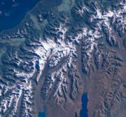
It is as much as 4 kilometres (2.5 mi) wide and 600 metres (1,968.5 ft) thick, and lies entirely within the borders of Aoraki/Mount Cook National Park
. The glacier covers an area of 101 square kilometres (39 sq mi) and starts at a height of 3000 metres (9,842.5 ft) above sea level. Snowfall during the winter and spring seasons accumulates to 50 metres (164 ft). After the summer melt, 7 metres (23 ft) remains.
The Tasman flows south from the southern slopes of the Minarets peak, along the eastern flank of New Zealand's two highest mountains, Mount Tasman
and its higher southern neighbour Aoraki/Mount Cook
.
Although its upper reaches are snow-covered, rocks carried by the glacier are exposed by ablation
along its course, and the lower glacier is entirely rock-covered. It is almost met near its end by the meltwater of the Murchison Glacier
, which approaches from the northeast before turning to flow beside the Tasman Glacier outside the moraine wall.
The waters from both these glaciers pool at the end of the glacier in Lake Tasman, before flowing south to join the outflow from the nearby Hooker
and Mueller Glacier
s in the wide valley of the Tasman River
, whose braided streams flow south into Lake Pukaki. They eventually flow into the Waitaki River
and to the Pacific Ocean
north of Oamaru
.
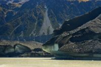
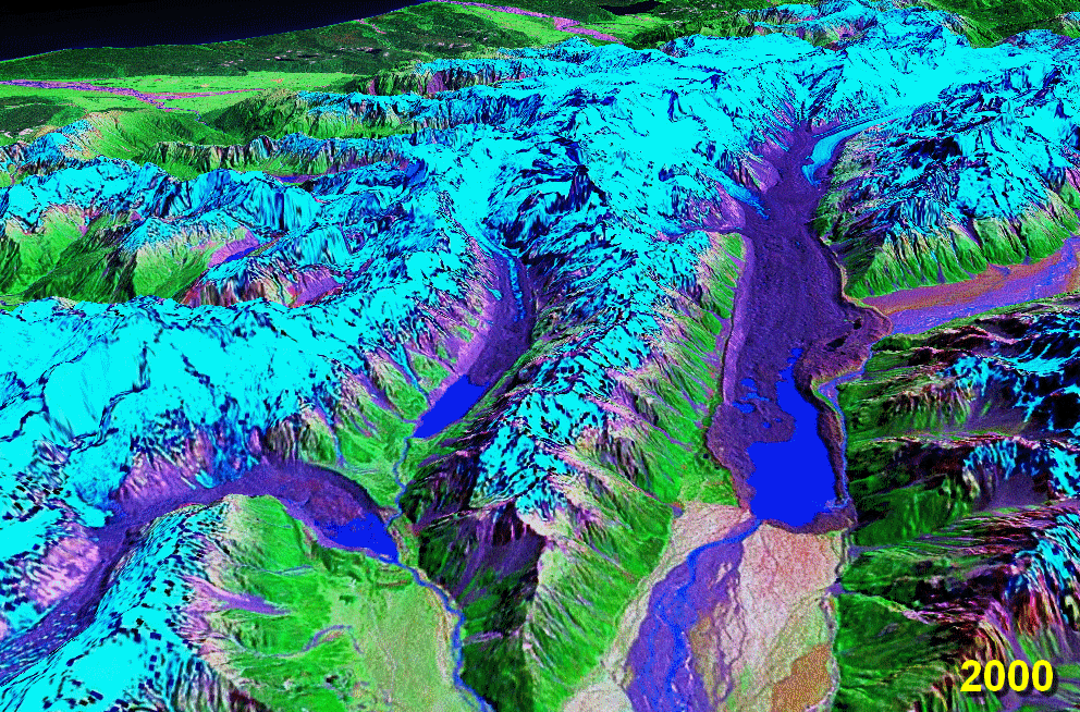 The glacier has retreated about 180 metres (590.6 ft) a year on average since the 1990s and the glacier is now in a period of faster retreat where the rate of retreat is calculated to be between 477 to 822 m (1,565 to 2,696.9 ft) each year. It is estimated that the Tasman Glacier will eventually disappear and the terminal Tasman Lake
will reach a maximum size in 10 to 19 years time. In 1973 Tasman Glacier had no terminal lake and by 2008 Tasman Lake
was 7 kilometres (4.3 mi) long, 2 kilometres (1.2 mi) wide, and 245 metres (803.8 ft) deep.
A large calving event was possibly triggered, or at least contributed to, by the 2011 Canterbury earthquake on 22 February 2011. On this day 30000000 metric tons (33,069,339.3 ST) to 40000000 metric tons (44,092,452.4 ST) of ice dropped from the terminal face of the Tasman Glacier and fell into the Tasman Lake. Boats were hit with tsunami
waves of up to 3.5 metres (11.5 ft) as the ice fell into the Tasman Lake under the glacier. Similar events in the past have been attributed to buoyancy effects, a result of high basal water pressures and increased lake level following heavy rainfall events.
Glacier
A glacier is a large persistent body of ice that forms where the accumulation of snow exceeds its ablation over many years, often centuries. At least 0.1 km² in area and 50 m thick, but often much larger, a glacier slowly deforms and flows due to stresses induced by its weight...
s which flow south and east towards the Mackenzie Basin
Mackenzie Basin
The Mackenzie Basin , is an elliptical intermontane basin, located in the Mackenzie and Waitaki Districts, near the centre of the South Island of New Zealand. It is the largest such basin in New Zealand...
from the Southern Alps
Southern Alps
The Southern Alps is a mountain range extending along much of the length of New Zealand's South Island, reaching its greatest elevations near the island's western side...
in New Zealand
New Zealand
New Zealand is an island country in the south-western Pacific Ocean comprising two main landmasses and numerous smaller islands. The country is situated some east of Australia across the Tasman Sea, and roughly south of the Pacific island nations of New Caledonia, Fiji, and Tonga...
's South Island
South Island
The South Island is the larger of the two major islands of New Zealand, the other being the more populous North Island. It is bordered to the north by Cook Strait, to the west by the Tasman Sea, to the south and east by the Pacific Ocean...
. It is New Zealand's longest glacier.
Geography
At 27 kilometres (16.8 mi) in length, Tasman Glacier is New Zealand's longest glacier.It is as much as 4 kilometres (2.5 mi) wide and 600 metres (1,968.5 ft) thick, and lies entirely within the borders of Aoraki/Mount Cook National Park
Aoraki/Mount Cook National Park
Aoraki/Mount Cook National Park is in the South Island of New Zealand near the town of Twizel. Aoraki/Mount Cook, New Zealand's highest mountain and Aoraki/Mount Cook village lie within the park...
. The glacier covers an area of 101 square kilometres (39 sq mi) and starts at a height of 3000 metres (9,842.5 ft) above sea level. Snowfall during the winter and spring seasons accumulates to 50 metres (164 ft). After the summer melt, 7 metres (23 ft) remains.
The Tasman flows south from the southern slopes of the Minarets peak, along the eastern flank of New Zealand's two highest mountains, Mount Tasman
Mount Tasman
Mount Tasman is New Zealand's second highest mountain, rising to a height of 3497 metres. It is located in the Southern Alps of the South Island, four kilometres to the north of its larger neighbour, Aoraki/Mount Cook...
and its higher southern neighbour Aoraki/Mount Cook
Aoraki/Mount Cook
Aoraki / Mount Cook is the highest mountain in New Zealand, reaching .It lies in the Southern Alps, the mountain range which runs the length of the South Island. A popular tourist destination, it is also a favourite challenge for mountain climbers...
.
Although its upper reaches are snow-covered, rocks carried by the glacier are exposed by ablation
Ablation
Ablation is removal of material from the surface of an object by vaporization, chipping, or other erosive processes. This occurs in spaceflight during ascent and atmospheric reentry, glaciology, medicine, and passive fire protection.-Spaceflight:...
along its course, and the lower glacier is entirely rock-covered. It is almost met near its end by the meltwater of the Murchison Glacier
Murchison Glacier
The Murchison Glacier is an long glacier flowing through Aoraki/Mount Cook National Park in the South Island of New Zealand. Lying to the east of Aoraki/Mount Cook, high in the Southern Alps, it flows southwestwards. The Murchison River, which takes its meltwater, flows under the larger Tasman...
, which approaches from the northeast before turning to flow beside the Tasman Glacier outside the moraine wall.
The waters from both these glaciers pool at the end of the glacier in Lake Tasman, before flowing south to join the outflow from the nearby Hooker
Hooker Glacier
Hooker Glacier is one of several glaciers close to the slopes of Aoraki/Mount Cook in the Southern Alps of New Zealand. Though not as large as its neighbour, the Tasman Glacier, it is still impressive, and is some 11 kilometres in length...
and Mueller Glacier
Mueller Glacier
The Mueller Glacier is a long glacier flowing through Aoraki/Mount Cook National Park in the South Island of New Zealand. It lies to the south of Aoraki/Mount Cook, high in the Southern Alps, and flows north...
s in the wide valley of the Tasman River
Tasman River
The Tasman River is an alpine braided river flowing through Canterbury, in New Zealand's South Island.The river's headwaters are in Aoraki/Mount Cook National Park, where it is the outflow of the Tasman and Murchison Glaciers and also, via a short tributary, of the Hooker and Mueller Glaciers.It...
, whose braided streams flow south into Lake Pukaki. They eventually flow into the Waitaki River
Waitaki River
The Waitaki River is a large river in the South Island of New Zealand, some 110 km long. It is the major river of the Mackenzie Basin.It is a braided river which flows through Lake Benmore, Lake Aviemore and Lake Waitaki. These are ultimately fed by three large glacial lakes, Pukaki, Tekapo,...
and to the Pacific Ocean
Pacific Ocean
The Pacific Ocean is the largest of the Earth's oceanic divisions. It extends from the Arctic in the north to the Southern Ocean in the south, bounded by Asia and Australia in the west, and the Americas in the east.At 165.2 million square kilometres in area, this largest division of the World...
north of Oamaru
Oamaru
Oamaru , the largest town in North Otago, in the South Island of New Zealand, is the main town in the Waitaki District. It is 80 kilometres south of Timaru and 120 kilometres north of Dunedin, on the Pacific coast, and State Highway 1 and the railway Main South Line connects it to both...
.
Recent retreat
Tasman Lake
Tasman Lake is a proglacial lake formed by the recent retreat of the Tasman Glacier in New Zealand's South Island.In the early 1970s, there were several small meltwater ponds on the Tasman Glacier. By 1990, these ponds had merged into Tasman Lake....
will reach a maximum size in 10 to 19 years time. In 1973 Tasman Glacier had no terminal lake and by 2008 Tasman Lake
Tasman Lake
Tasman Lake is a proglacial lake formed by the recent retreat of the Tasman Glacier in New Zealand's South Island.In the early 1970s, there were several small meltwater ponds on the Tasman Glacier. By 1990, these ponds had merged into Tasman Lake....
was 7 kilometres (4.3 mi) long, 2 kilometres (1.2 mi) wide, and 245 metres (803.8 ft) deep.
A large calving event was possibly triggered, or at least contributed to, by the 2011 Canterbury earthquake on 22 February 2011. On this day 30000000 metric tons (33,069,339.3 ST) to 40000000 metric tons (44,092,452.4 ST) of ice dropped from the terminal face of the Tasman Glacier and fell into the Tasman Lake. Boats were hit with tsunami
Tsunami
A tsunami is a series of water waves caused by the displacement of a large volume of a body of water, typically an ocean or a large lake...
waves of up to 3.5 metres (11.5 ft) as the ice fell into the Tasman Lake under the glacier. Similar events in the past have been attributed to buoyancy effects, a result of high basal water pressures and increased lake level following heavy rainfall events.
See also
- List of glaciers
- Retreat of glaciers since 1850 - Oceania
- List of glacier NZ
Further reading
- Satellite Image Atlas of Glaciers of the World, Glaciers of New Zealand, Chinn, T.H., USGS Professional Paper 1386, 1988.
External links
- Department of Conservation - Tasman Valley walking tracks