
.gif)
National Route 12 (Argentina)
Encyclopedia
National Route 12 is a road in Argentina
, connecting the northeast section to the rest of the country. It runs through the provinces of Misiones
, Corrientes
, Entre Ríos
and Buenos Aires
.
Starting south of the city of Zárate in Buenos Aires Province, and crossing the Paraná River
, through the Zárate-Brazo Largo Bridge
, continues to the provincial capitals of Paraná, Corrientes and Posadas
, ending at the Fraternity Bridge
, in the city of Puerto Iguazú
, bordering with Brazil
. The road continues within Brazil as BR-469. Its length of 1580 km (982 mi), is fully paved.
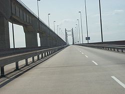
In the Zárate - Ceibas section, the road is a wide, 4-lane highway. Before the opening of the Zárate - Brazo Largo bridgle, on 14 December 1977. cars had to cross the Paraná de las Palmas and Paraná Guazú rivers by barge. The section between the rivers, in Talavera Island, was a treated, unpaved road.
Construction on the second lane (widening) on the 45 km (28 mi) section between Brazo Largo and Ceibas (km markers 115 to 160) was started on May 1997, opening to the public on 12 October 1999.
National Law 25,680 published in the Official Bulletin on 3 January 2003 designates the section from Brazo Largo to Ceibas as David Della Chiesa road.
 Length: 30 km (km marker 82 to 112).
 Length: 678 km (km markers 647 to 1325). RN12 is called John F. Kennedy Highway, between the capital cities of Corrientes and Misiones Provinces, Decree 8012 and Law 16484 of 24 September 1964, and Soberanía Nacional on the section Saladas - Goya, Decree 427 of 10 March 1981.
 Length: 317 km (km 1325 a 1642).
The section between the junction with National Route 9
in Zárate and the junction with National Route 14 in Ceibas is part of Corridor Vial 18, under the management of Caminos del Río Uruguay (CRUSA) with a toll booth in Zárate (km marker 85).
In 1996 the concession was extended to 28 years with the condicion that the bidding company built a highway between the Complejo Unión Nacional and Gualeguaychú. The section between the General Justo José de Urquiza bridge and Ceibas was completed on October 12, 1999. Due to the currency devaluation of 2002, road work in the Ceibas - Gualeguaychú section was delayed.
The Virgen de Itatí Concesionaria de Obras Viales (VICOV) company took control of Corridor Vial 13, including, among others, Route 12 between km markers 871 and 1641, in the provinces of Corrientes and Misiones, from the junction with National Route 123 to the access to the Tancredo Neves International Bridge, excluding the section near the provincial capital city of Posadas (km 1336-1349) installing toll booths in Riachuelo (km 1014), Ituzaingó (km 1262), Santa Ana (km 1374) and Colonia Victoria
(km 1551).
In 2003 the Corredores Viales concession contracts expired, and the numbering system was changed when calling for a new bidding process.
Corridor Vial 6 is now controlled by Empresa Concesionaria Vial (Emcovial) and includes Route 12 in the same section as the previous concession.
The original road started in Buenos Aires
, passing through General Pacheco
, Campana
and Zárate. The section between Zárate's port and Puerto Constanza, in Entre Ríos Province, crossed the Paraná river by barge in a 3-hour crossing.
After the change of route of National Route 9
, in the late 1950s, the section from Avenida General Paz
and Campana was change to RN12. In 2005 the 8 km section between National Route 9 in Campana and the Bartolomé Mitre bridge access over the Paraná de las Palmas river changed to Buenos Aires provincial jurisdiction as a new section of Provincial Route 6. RN12 runs over the ol roadbed of National Route 193 to the bridge over National Route 9 in Zárate.
After Ceibas it followed the present National Route 14, traversing near Gualeguaychú, and the present Provincial Route 20, passing through Urdinarrain
, Basavilbaso
, Villaguay
, Federal (Entre Ríos province)
and San José de Feliciano
.
In Corrientes Province, the road continued through Provincial Route 23 passing by Sauce
and Perugorría, then by the present Provincial Route 24 until the junction with the present National Route 12.
This 580 km (360 mi) old roadbed changed to federal control by National Decree 1595 of 1979 except the National Route 14 section between Ceibas and the junction with Provincial Route 20.
ON the new roadbed the section between General Galarza and Nogoyá, on the south of Entre Ríos Province was still unopened. In 2005, the Dirección Nacional de Vialidad signed an agreement with its provincial counterpart to receive transfer of sections of provincial routes 6 and 39 to complete the missing sections of RN12.
. Emcovial Manages the section between from the National Route 123 junction to Puerto Iguazú
.
Argentina
Argentina , officially the Argentine Republic , is the second largest country in South America by land area, after Brazil. It is constituted as a federation of 23 provinces and an autonomous city, Buenos Aires...
, connecting the northeast section to the rest of the country. It runs through the provinces of Misiones
Misiones Province
Misiones is one of the 23 provinces of Argentina, located in the northeastern corner of the country in the Mesopotamiсa region. It is surrounded by Paraguay to the northwest, Brazil to the north, east and south, and Corrientes Province of Argentina to the southwest.- History :The province was...
, Corrientes
Corrientes Province
Corrientes is a province in northeast Argentina, in the Mesopotamia region. It is surrounded by : Paraguay, the province of Misiones, Brazil, Uruguay, and the provinces of Entre Rios, Santa Fe and Chaco.-History:...
, Entre Ríos
Entre Ríos Province
Entre Ríos is a northeastern province of Argentina, located in the Mesopotamia region. It borders the provinces of Buenos Aires , Corrientes and Santa Fe , and Uruguay in the east....
and Buenos Aires
Buenos Aires Province
The Province of Buenos Aires is the largest and most populous province of Argentina. It takes the name from the city of Buenos Aires, which used to be the provincial capital until it was federalized in 1880...
.
Starting south of the city of Zárate in Buenos Aires Province, and crossing the Paraná River
Paraná River
The Paraná River is a river in south Central South America, running through Brazil, Paraguay and Argentina for some . It is second in length only to the Amazon River among South American rivers. The name Paraná is an abbreviation of the phrase "para rehe onáva", which comes from the Tupi language...
, through the Zárate-Brazo Largo Bridge
Zárate-Brazo Largo Bridge
The Zárate-Brazo Largo Bridges are two cable-stayed road and railway bridges in Argentina, crossing the Paraná River between the cities of Zárate, Buenos Aires Province, and Brazo Largo, Entre Ríos Province....
, continues to the provincial capitals of Paraná, Corrientes and Posadas
Posadas, Misiones
Posadas is the capital city of the Argentine province of Misiones, located at the south of the province, on the left-hand shore of the Paraná River, opposite Encarnación, Paraguay. The city has an area of 965 km² and a population of 323,739 ....
, ending at the Fraternity Bridge
Fraternity Bridge
The Tancredo Neves Bridge, better known as Fraternity Bridge connects the Brazilian city of Foz do Iguaçu with the Argentine Puerto Iguazú, crossing over the Iguassu River....
, in the city of Puerto Iguazú
Puerto Iguazú
Puerto Iguazú is a frontier city in the province of Misiones, Argentina. With a population of 82.227 ,it is the fifth largest city in the Province, after Posadas, Oberá, Eldorado and San Vicente....
, bordering with Brazil
Brazil
Brazil , officially the Federative Republic of Brazil , is the largest country in South America. It is the world's fifth largest country, both by geographical area and by population with over 192 million people...
. The road continues within Brazil as BR-469. Its length of 1580 km (982 mi), is fully paved.
In the Zárate - Ceibas section, the road is a wide, 4-lane highway. Before the opening of the Zárate - Brazo Largo bridgle, on 14 December 1977. cars had to cross the Paraná de las Palmas and Paraná Guazú rivers by barge. The section between the rivers, in Talavera Island, was a treated, unpaved road.
Construction on the second lane (widening) on the 45 km (28 mi) section between Brazo Largo and Ceibas (km markers 115 to 160) was started on May 1997, opening to the public on 12 October 1999.
National Law 25,680 published in the Official Bulletin on 3 January 2003 designates the section from Brazo Largo to Ceibas as David Della Chiesa road.
Cities
The cities with more than 5,000 inhabitants crossed by the road (from South to North) are:Buenos Aires Province
- Zárate PartidoZárate PartidoZárate Partido is a partido of Buenos Aires Province in Argentina.The provincial subdivision has a population of about 101,000 inhabitants in an area of , and its capital city is Zárate, which is located around from Buenos Aires.-External links:...
: Zárate (km 84). - Zárate Partido - Islas Sector: no towns.
- Campana PartidoCampana PartidoCampana Partido is a partido in the north-east of Buenos Aires Province in Argentina.The provincial subdivision has a population of around 84,000 inhabitants in an area of 982 km² , and its capital city is Campana, which is located 75 km from Buenos Aires.-Economy:The economy...
: no towns.
Entre Ríos Province
Length: 535 km (km 112 a 647).- Islas del Ibicuy Department: no towns with more than 5,000 inhabitants.
- Gualeguay Department: GualeguayGualeguayGualeguay may refer to:* Gualeguay, Entre Ríos* Gualeguay Department* Gualeguay River...
(km 231) - Nogoyá Department: NogoyáNogoyáNogoyá is a city in the province of Entre Ríos, Argentina. It has 22,285 inhabitants per the , and is the head town of the Nogoyá Department. It lies in the southwest of the province, by the Nogoyá Stream , about 95 km southeast from the provincial capital Paraná, on National Route 12.The main...
(km 337). - Diamante Department: General RamírezGeneral RamírezGeneral Ramírez is a village and municipality in Entre Ríos Province in northeastern Argentina.-References:...
(km 376) - Paraná Department: CrespoCrespo, Entre RíosCrespo is a city in the Argentine province of Entre Ríos, some 40 km from the provincial capital Paraná. It has around 18,000 inhabitants , most of whom are descendants of Volga Germans who migrated from Russia to Argentina from 1875 onwards. The town's German heritage is reflected in the annual...
(km 401), San Benito and Paraná (km 445). - La Paz DepartmentLa Paz, Entre RíosLa Paz is a city in the province of Entre Ríos in the Argentine Mesopotamia. It has about 25,000 inhabitants as per the , and is the head town of the department of the same name....
: La PazLa Paz, Entre RíosLa Paz is a city in the province of Entre Ríos in the Argentine Mesopotamia. It has about 25,000 inhabitants as per the , and is the head town of the department of the same name....
(km 601).
Corrientes Province
- Esquina DepartmentEsquina DepartmentEsquina Department is a department of Corrientes Province in Argentina.The provincial subdivision has a population of about 30,000 inhabitants in an area of 3,723 km², and its capital city is Esquina, which is located around 760 km from Capital Federal....
: EsquinaEsquina, CorrientesEsquina is a city in Corrientes Province, Argentina. It is the capital of the Esquina Department.-Festivals:In January and February many tourists visit Esquina to enjoy the street carnivals....
(km 684) - Goya DepartmentGoya DepartmentGoya Department is a department of Corrientes Province in Argentina.The provincial subdivision has a population of about 87,349 inhabitants in an area of 4,678 km², and its capital city is Goya, which is the second most populous city in Corrientes Province. It is located around 815 km from Capital...
: GoyaGoya, CorrientesGoya is a city in the south-west of the province of Corrientes in the Argentine Mesopotamia. It has about 87,000 inhabitants as of the .The city lies on the eastern shore of the Paraná River, opposite Reconquista, Santa Fe, 222 kilometres south from the provincial capital and 715 kilometres...
(km 795) - Lavalle DepartmentLavalle Department, CorrientesLavalle Department is a department of Corrientes Province in Argentina.The provincial subdivision has a population of about 26,250 inhabitants in an area of 1,480 km², and its capital city is Lavalle.-Settlements:*Cruz de los Milagros...
: no towns with more than 5,000 inhabitants. - San Roque DepartmentSan Roque DepartmentSan Roque Department is a department of Corrientes Province in Argentina.The provincial subdivision has a population of about 17,951 inhabitants in an area of 2,243 km², its capital city is San Roque.- Settlements :* Nueve de Julio* Chavarría...
: no towns with more than 5,000 inhabitants, but the road passes through the Department seat, San RoqueSan Roque, CorrientesSan Roque is a city in Corrientes Province, Argentina. It is the head town of the San Roque Department.The settlement was established on October 11, 1773....
(km 902) - Bella Vista DepartmentBella Vista DepartmentBella Vista Department is a department of Corrientes Province in Argentina.The provincial subdivision has a population of about 35,350 inhabitants in an area of 1,695 km², and its capital city is Bella Vista, which is located around 891 km from Capital Federal.-External links:*...
: no towns with more than 5,000 inhabitants. - Saladas DepartmentSaladas DepartmentSaladas Department is a department of Corrientes Province in Argentina.The provincial subdivision has a population of about 21,470 inhabitants in an area of 1,981 km², and its capital city is Saladas, which is located around 930km from Capital Federal....
: no towns with more than 5,000 inhabitants. - Empedrado DepartmentEmpedrado DepartmentEmpedrado Department is a department of Corrientes Province in Argentina.The provincial subdivision has a population of about 14,721 inhabitants in an area of 1,958 km², and its capital city is Empedrado, which is located around 1,030 km from Capital Federal.- External links :*...
: EmpedradoEmpedrado, CorrientesEmpedrado is a city in Corrientes Province, Argentina.It is the capital of the Empedrado Department....
(km 977) - Capital Department: CorrientesCorrientesCorrientes is the capital city of the province of Corrientes, Argentina, located on the eastern shore of the Paraná River, about from Buenos Aires and from Posadas, on National Route 12...
(km 1030) - San Cosme DepartmentSan Cosme DepartmentSan Cosme Department is a department of Corrientes Province in Argentina.The provincial subdivision has a population of about 13,189 inhabitants in an area of 595 km², and its capital city is San Cosme.-Settlements:*Paso de la Patria*San Cosme...
: no towns with more than 5,000 inhabitants, but the road passes through the Department seat, San CosmeSan Cosme, CorrientesSan Cosme is a town in Corrientes Province, Argentina. It is the capital of San Cosme Department....
(km 1061) - Itatí DepartmentItatí DepartmentItatí Department is a department of Corrientes Province in Argentina.The provincial subdivision has a population of about 8,774 inhabitants in an area of 890 km², and its capital city is Itatí, which is located around 1,095 km from Capital Federal....
: ItatíItatí, CorrientesItatí is a town in the north of the province of Corrientes, Argentina. It has 7,902 inhabitants as per the . It lies some 60 km east of the provincial capital Corrientes, by the Paraná River, not far upstream from its confluence with the Paraguay River, on the northern provincial border, which...
(km 1089) - Berón de Astrada DepartmentBerón de Astrada DepartmentBerón de Astrada Department is a department of Corrientes Province in Argentina.The provincial subdivision has a population of about 2,294 inhabitants in an area of 804 km², and its capital city is Berón de Astrada, which is located around 1,116 km from Capital Federal....
: no towns with more than 5,000 inhabitants. - General Paz DepartmentGeneral Paz DepartmentGeneral Paz Department is a department of Corrientes Province in Argentina.The provincial subdivision has a population of about 14,725 inhabitants in an area of , and its capital city is Caá Catí.-Settlements:*Caá Catí*Itá Ibaté*Lomas de Vallejos...
: no towns with more than 5,000 inhabitants. - San Miguel DepartmentSan Miguel Department, CorrientesSan Miguel Department is a department of Corrientes Province in Argentina.The provincial subdivision has a population of about 10,252 inhabitants in an area of 2,863 km², and its capital city is San Miguel.-Settlements:*Loreto*San Miguel...
: no towns with more than 5,000 inhabitants. - Ituzaingó DepartmentItuzaingó DepartmentItuzaingó Department is a department of Corrientes Province in Argentina.The provincial subdivision has a population of about 30,565 inhabitants in an area of 8,613 km², and its capital city is Ituzaingó, which is located around 1,070 km from Capital Federal.-Settlements:*Colonia...
: Ituzaingó (km 1256)
Misiones Province
- Capital Department, Misiones: PosadasPosadas, MisionesPosadas is the capital city of the Argentine province of Misiones, located at the south of the province, on the left-hand shore of the Paraná River, opposite Encarnación, Paraguay. The city has an area of 965 km² and a population of 323,739 ....
(km 1344), Miguel Lanús] (km 1347) and Garupá (km 1354). - Candelaria: Candelaria (km 1361). The road also passes through the Department seat Santa Ana (km 1383).
- San Ignacio: San Ignacio (km 1398) and Jardín América (km 1437).
- Libertador General San Martín: Puerto RicoPuerto Rico, MisionesPuerto Rico is the capital city of the Libertador General San Martín Department, in the Misiones Province of Argentina.It is located at 26° 48' south latitude and 55° 01' west longitude, along the Paraná River...
(km 1473). - Montecarlo Department: Montecarlo (km 1521) and Puerto Piray (km 1531).
- Eldorado DepartmentEldorado DepartmentEldorado is a town of about 70,000 people. Located in the north of Misiones, Argentina 1 hours from Iguazú and 2 hours from Posadas , it relied largely on sawmills in the area for its economy, but many independent sawmill operators were put out of business or bought out by a firm called Alto Parana...
: EldoradoEldorado, MisionesEldorado is a city in the center-northeast of the province of Misiones, Argentina. It has 54,189 inhabitants as per the , making it the third most populated city in the province, and is the head town of the Eldorado Department...
(km 1543). - Iguazú: Puerto Esperanza (km 1591), Colonia Wanda] (km 1601), [Puerto Libertad (km 1608) and Puerto IguazúPuerto IguazúPuerto Iguazú is a frontier city in the province of Misiones, Argentina. With a population of 82.227 ,it is the fifth largest city in the Province, after Posadas, Oberá, Eldorado and San Vicente....
(km 1640).
Administration
In 1990 concessions were leased with toll collection on the busiest national roads, dividing the country in zones called "Corredores Viales".The section between the junction with National Route 9
National Route 9 (Argentina)
National Route 9 is a major road in Argentina, which runs from the center-east to the northwest of the country, crossing the provinces of Buenos Aires, Santa Fe, Córdoba, Santiago del Estero, Tucumán, Salta and Jujuy...
in Zárate and the junction with National Route 14 in Ceibas is part of Corridor Vial 18, under the management of Caminos del Río Uruguay (CRUSA) with a toll booth in Zárate (km marker 85).
In 1996 the concession was extended to 28 years with the condicion that the bidding company built a highway between the Complejo Unión Nacional and Gualeguaychú. The section between the General Justo José de Urquiza bridge and Ceibas was completed on October 12, 1999. Due to the currency devaluation of 2002, road work in the Ceibas - Gualeguaychú section was delayed.
The Virgen de Itatí Concesionaria de Obras Viales (VICOV) company took control of Corridor Vial 13, including, among others, Route 12 between km markers 871 and 1641, in the provinces of Corrientes and Misiones, from the junction with National Route 123 to the access to the Tancredo Neves International Bridge, excluding the section near the provincial capital city of Posadas (km 1336-1349) installing toll booths in Riachuelo (km 1014), Ituzaingó (km 1262), Santa Ana (km 1374) and Colonia Victoria
Colonia Victoria
Colonia Victoria is a village and municipality in Misiones Province in northeastern Argentina.-References:...
(km 1551).
In 2003 the Corredores Viales concession contracts expired, and the numbering system was changed when calling for a new bidding process.
Corridor Vial 6 is now controlled by Empresa Concesionaria Vial (Emcovial) and includes Route 12 in the same section as the previous concession.
Old roadbed
Originally National Route 12 had a different layout through the provinces of Buenos Aires, Entre Ríos and Corrientes.The original road started in Buenos Aires
Buenos Aires
Buenos Aires is the capital and largest city of Argentina, and the second-largest metropolitan area in South America, after São Paulo. It is located on the western shore of the estuary of the Río de la Plata, on the southeastern coast of the South American continent...
, passing through General Pacheco
General Pacheco
General Pacheco is a city in Tigre Partido, Buenos Aires Province, Argentina. The city's position inside Tigre significantly sums up to its importance inside the partido...
, Campana
Campana, Buenos Aires
Campana is a city in the Buenos Aires Province, Argentina, in the Campana Partido. It is located about from Buenos Aires City, on the right-hand margin of the Paraná River, Its population is 84,000 inhabitants as per the ....
and Zárate. The section between Zárate's port and Puerto Constanza, in Entre Ríos Province, crossed the Paraná river by barge in a 3-hour crossing.
After the change of route of National Route 9
National Route 9 (Argentina)
National Route 9 is a major road in Argentina, which runs from the center-east to the northwest of the country, crossing the provinces of Buenos Aires, Santa Fe, Córdoba, Santiago del Estero, Tucumán, Salta and Jujuy...
, in the late 1950s, the section from Avenida General Paz
Avenida General Paz
Avenida General Paz is a beltway freeway surrounding the city of Buenos Aires. Roughly following the boundary between the city and Buenos Aires Province, it is one of the few motorways in Argentina that is toll-free...
and Campana was change to RN12. In 2005 the 8 km section between National Route 9 in Campana and the Bartolomé Mitre bridge access over the Paraná de las Palmas river changed to Buenos Aires provincial jurisdiction as a new section of Provincial Route 6. RN12 runs over the ol roadbed of National Route 193 to the bridge over National Route 9 in Zárate.
After Ceibas it followed the present National Route 14, traversing near Gualeguaychú, and the present Provincial Route 20, passing through Urdinarrain
Urdinarrain
Urdinarrain is a city in the center-south of the province of Entre Ríos, Argentina, 240 km southeast from the provincial capital Paraná and 40 km west from Gualeguaychú, on Provincial Route 20. It has 7,992 inhabitants as per the ....
, Basavilbaso
Basavilbaso
Basavilbaso is a town in the center region of the province of Entre Ríos, Argentina, about from Concepción del Uruguay. It has about 9,400 inhabitants as per the . Locals often shorten the name to Basso....
, Villaguay
Villaguay
Villaguay is a city in the province of Entre Ríos in the Argentine Mesopotamia. It has about 48,000 inhabitants as of the , and is the head town of the department of the same name....
, Federal (Entre Ríos province)
Federal, Entre Ríos
Federal is a city in the province of Entre Ríos, Argentina. It had 16,333 inhabitants per the , and is the head town of the Federal Department. It lies in the center-north of the province, by National Route 127, about 190 km northeast of the provincial capital Paraná.The basis of the local economy...
and San José de Feliciano
San José de Feliciano
San José de Feliciano is a city in the north of the province of Entre Ríos, Argentina, near the border with Corrientes. It has 11,137 inhabitants as per the , and is the head town of the Feliciano Department.The city was officially founded on 1818...
.
In Corrientes Province, the road continued through Provincial Route 23 passing by Sauce
Sauce, Corrientes
Sauce is a town in Corrientes Province, Argentina. It is the capital of Sauce Department. It is separated from Entre Ríos Province by the Guayquiraró River....
and Perugorría, then by the present Provincial Route 24 until the junction with the present National Route 12.
This 580 km (360 mi) old roadbed changed to federal control by National Decree 1595 of 1979 except the National Route 14 section between Ceibas and the junction with Provincial Route 20.
ON the new roadbed the section between General Galarza and Nogoyá, on the south of Entre Ríos Province was still unopened. In 2005, the Dirección Nacional de Vialidad signed an agreement with its provincial counterpart to receive transfer of sections of provincial routes 6 and 39 to complete the missing sections of RN12.
External links
Caminos del Río Uruguay Manages the section between Zárate and CeibasCeibas
Ceibas is a village and municipality in Entre Ríos Province in northeastern Argentina.It is split in two halves by Ruta Nacional 12, while Ruta Nacional 14 starts here. The village is totally dominated by this large and important highway junction.Ceibas lies 156 km from Buenos Aires.-References:...
. Emcovial Manages the section between from the National Route 123 junction to Puerto Iguazú
Puerto Iguazú
Puerto Iguazú is a frontier city in the province of Misiones, Argentina. With a population of 82.227 ,it is the fifth largest city in the Province, after Posadas, Oberá, Eldorado and San Vicente....
.