
Maryland Route 235
Encyclopedia
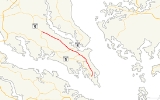
Maryland Route 235 (MD 235) is a state highway
in the U.S. state
of Maryland
. Known as Three Notch Road, the state highway runs 30.63 miles (49.3 km) between its southern intersection with MD 5
in Ridge
and its northern intersection with MD 5 near Mechanicsville
. While the southern part of the state highway is a quiet rural road, the northern part of MD 235 is a four- to six-lane divided highway connecting Naval Air Station Patuxent River
(NAS Patuxent River) and the Washington, D.C.
metro area in conjunction with MD 5. Due to the military base, the state highway is part of the National Highway System
between the main entrance to the facility at MD 246
in Lexington Park
and the northern terminus at MD 5. MD 235 is also the longest state highway in Maryland to run entirely through one county.
Three Notch Road has been the main highway between northern St. Mary's County and Point Lookout
since the colonial era. The highway was reconstructed as the modern MD 235 between 1923 and 1938. The state highway was then completely rebuilt during World War II
to serve the recently established NAS Patuxent River. Between 1960 and 1985, MD 235 was converted into a four-lane divided highway to the west and north of the military base. In the face of increasing activity at the base, the highway adjacent to NAS Patuxent River was expanded to six lanes in the early 2000s.
and to the west of The Elms Wildlife Management Area before meeting MD 489
(Park Hall Road) in Park Hall Estates
. The state highway passes a section of old alignment on the east, then turns northwest and intersects MD 712
(Forest Park Road) and Hermanville Road in the hamlet of Hermanville at the southern edge of NAS Patuxent River. MD 235 expands to a five-lane road with center turn lane as the highway runs along the western edge of the military base. The state highway starts to pass residential subdivisions before reaching the intersection with MD 246 (Great Mills Road) in Lexington Park. MD 235 continues northwest along the boundary of NAS Patuxent River as a six-lane divided highway with continuous right-turn lanes, lined on its southbound side with a commercial strip. Beyond Pegg Road, which heads east to another entrance to the military base, businesses start lining both side of the road. After passing Millstone Landing Road, which leads to St. Richard's Manor
, the state highway enters California
, where the highway intersects MD 237
(Chancellors Run Road). A short distance to the north, MD 235 intersects MD 4
, which heads west as St. Andrew's Church Road and east as Patuxent Beach Road toward the Governor Thomas Johnson Bridge over the Patuxent River to Calvert County
.
Beyond MD 4, MD 235 reduces to a four-lane divided highway and passes to the east of St. Mary's County Regional Airport
. The first of several sections of old alignment, MD 944
(Mervell Dean Road), splits to the north. MD 235 continues past Clarks Landing Road before intersecting MD 245
(Hollywood Road/Sotterley Road) in Hollywood
. Another old alignment, Clover Hill Road, splits to the west as the highway passes through Hillville. Beyond the intersection with MD 472
(North Sandgates Road), MD 235 passes through Oakville, where another old alignment, Oakville Road, splits to the north before the main road intersects MD 247
(Loveville Road). Mt. Zion Church Road, yet another old alignment, splits to the north in the hamlet of Laurel Grove before MD 235 intersects the eastern terminus of MD 6
(New Market–Turner Road) and Morganza–Turner Road in Oraville. The final old alignment of MD 235, Harpers Corner Road, splits to the west shortly before the state highway reaches its northern terminus at MD 5 near Mechanicsville. MD 5 heads southwest as two-lane Point Lookout Road toward Leonardtown
. Northbound MD 5 continues straight on the divided highway as Three Notch Road toward Charlotte Hall
and Waldorf
.
and Chesapeake Bay
. The Patuxent Main Road later became known as the Three Notch Road based on a 1704 law that stated "three notches of equal distance marked on the trees indicated a road leading to a ferry." The whereabouts of the ferry to which this road led are unknown. After 200 years of little improvement, reconstruction of the Three Notch Road by the Maryland State Roads Commission
began in 1923 when the highway was rebuilt as a 15 feet (4.6 m) wide gravel road from MD 5 near Mechanicsville south to MD 472 in Oakville. The gravel road was extended south from Oakville 1 miles (1.6 km) to Friendship School Road in 1924.
Construction on Three Notch Road resumed in 1926 when two sections were placed under construction. A 1 miles (1.6 km) segment of gravel highway was constructed south from MD 246 in Jarboesville (now Lexington Park) toward Hermanville in 1926 and 1927. The northern segment of MD 235 was extended to Hillville in 1928 and to Hollywood in 1929. The southern gravel section of the highway was extended 1 miles (1.6 km) south to Hermanville in 1930. Also in 1930, construction on the 6.5 miles (10.5 km) gap between Hollywood and Jarboesville began and a new segment of MD 235 was started from Ridge north 3 miles (4.8 km) to Dameron. The Ridge–Dameron segment was completed in 1932 and the gravel highway from Hollywood to Jarboesville was finished in 1933. The gravel section constructed from Ridge reached Bay Forest Road by 1935 and Hermanville in 1938, completing MD 235.
Immediately after the beginning of U.S. involvement in World War II, the U.S. Navy made plans to construct a naval air station on the Cedar Point peninsula near Jarboesville. MD 235 was marked for an upgrade from MD 5 to Jarboesville both to connect the new military installation with Washington and to allow the road to handle the heavy military traffic that would travel the highway during the military base's construction and operations. The highway was under construction by the end of 1942. The highway's gravel surface was widened as a first layer and surface treated in autumn 1943 to help heavy traffic during the winter. In spring 1944 the first layer was scarified and the top 4 inches (10.2 cm) were mixed with asphalt
to form a base. This base was covered with a 2 inches (5.1 cm) wearing surface of bituminous concrete
. MD 235 was also reconstructed in this manner from Jarboesville to Hermanville in 1944 and 1945; included in that project was the construction of MD 712 to provide a modern highway to the naval air station's South Gate. During the reconstruction of MD 235, the highway was relocated in many places between Mechanicsville and Hollywood to remove substandard curves and avoid grade crossings with the southern extension of the Washington, Brandywine and Point Lookout Railroad
that the U.S. Navy constructed contemporaneously to provide a rail link to the military base. Many of the bypassed stretches of highway—which included Harpers Corner Road in Oraville, Mount Zion Church Road in Laurel Grove, Oakville Road in Oakville, Clover Hill Road in Hillville, Old Three Notch Road in Hollywood, and the southernmost portion of Mervell Dean Road—were designated as sections of MD 722.
The next major project along MD 235 was the reconstruction of the 1930s gravel highway between Ridge and Hermanville. Construction began in 1957 from Hermanville and was completed south to Park Hall in 1959, with the remainder of the highway completed around 1960. MD 235 was relocated between Park Hall and Hermanville, leaving behind Poplar Ridge Road as an old alignment. Also in 1960, the state highway was expanded to a divided highway from Hermanville to Lexington Park. MD 235 was widened to a divided highway from Hollywood to Hillville in 1968, from Mechanicsville to Oakville in 1969, and from MD 246 in Lexington Park to Town Creek Drive in California in 1973. Two sections of divided highway were completed in 1982: from Town Creek Drive to just north of the newly-constructed MD 4 intersection in California; and from Oakville to Hillville. The final segment of MD 235 between Hermanville and Mechanicsville to be expanded to a divided highway was completed from California to Hollywood in 1985. The portion of the state highway from just north of St. Mary's County Regional Airport to just south of MD 245 in Hollywood was relocated to the west along the right-of-way of the Washington, Brandywine and Point Lookout Railroad, which had earlier been abandoned. The bypassed highway was renamed as a northward extension of Mervell Dean Road and designated MD 944.
MD 235 was widened in Lexington Park and California between 2000 and 2004 due to increased activity at the military base and its supporting industries. The state highway was widened to six lanes from north of Pegg Road to Town Creek Drive in 2000 and from Town Creek Drive to just north of MD 4 in 2001. Expansion to six lanes occurred from FDR Boulevard to north of Pegg Road in 2003. The final section of widening occurred in 2004 when the six-lane section was extended south from FDR Boulevard to MD 246. MD 235 between MD 712 and MD 246 was transformed from a four-lane divided highway to a five-lane road with center turn lane in 2004 as well.
{| class=wikitable
|-
!Location
!Mile
!Destinations
!Notes
|-
|Ridge
|0.00
|
|Southern terminus
|-
|Park Hall
|7.64
|
|
|-
|Hermanville
|9.85
|
|
|-
|Lexington Park
|11.93
|
|
|-
|rowspan=2|California
|14.91
|
|
|-
|16.60
|
|
|-
|rowspan=3|Hollywood
|18.66
|Clarks Landing Road east
|Unsigned MD 944C
; former MD 574
|-
|20.48
|
|Old alignment of MD 235
|-
|20.71
|
|
|-
|rowspan=2|Oakville
|25.85
|
|
|-
|26.60
|
|
|-
|Oraville
|29.25
|
|-
|Mechanicsville
|30.63
|
|Northern terminus
State highway
State highway, state road or state route can refer to one of three related concepts, two of them related to a state or provincial government in a country that is divided into states or provinces :#A...
in the U.S. state
U.S. state
A U.S. state is any one of the 50 federated states of the United States of America that share sovereignty with the federal government. Because of this shared sovereignty, an American is a citizen both of the federal entity and of his or her state of domicile. Four states use the official title of...
of Maryland
Maryland
Maryland is a U.S. state located in the Mid Atlantic region of the United States, bordering Virginia, West Virginia, and the District of Columbia to its south and west; Pennsylvania to its north; and Delaware to its east...
. Known as Three Notch Road, the state highway runs 30.63 miles (49.3 km) between its southern intersection with MD 5
Maryland Route 5
Maryland Route 5 is a long state highway that runs north–south in the U.S. state of Maryland. The highway runs from Point Lookout in St. Mary's County north to the Washington, D.C. border in Suitland, Prince George's County....
in Ridge
Ridge, Maryland
Ridge is an unincorporated community in St. Mary's County, Maryland, United States. Bard's Field was listed on the National Register of Historic Places in 1976. It is near the southernmost tip of the western shore of Maryland, known as Point Lookout, has bodies of water on both sides, and has two...
and its northern intersection with MD 5 near Mechanicsville
Mechanicsville, Maryland
For the Census Designated area in Montgomery County formerly known as Mechanicsville see Olney, MarylandMechanicsville is an unincorporated community in St. Mary's County, Maryland. It is adjacent to the community of Charlotte Hall, which is known for its agriculture, Amish population, large...
. While the southern part of the state highway is a quiet rural road, the northern part of MD 235 is a four- to six-lane divided highway connecting Naval Air Station Patuxent River
Naval Air Station Patuxent River
"Pax River" redirects here. For the river, see Patuxent River.Naval Air Station Patuxent River , also known as NAS Pax River, is a United States Naval Air Station located in St. Mary's County, Maryland on the Chesapeake Bay near the mouth of the Patuxent River. It is home to the U.S...
(NAS Patuxent River) and the Washington, D.C.
Washington, D.C.
Washington, D.C., formally the District of Columbia and commonly referred to as Washington, "the District", or simply D.C., is the capital of the United States. On July 16, 1790, the United States Congress approved the creation of a permanent national capital as permitted by the U.S. Constitution....
metro area in conjunction with MD 5. Due to the military base, the state highway is part of the National Highway System
National Highway System (United States)
The National Highway System is a network of strategic highways within the United States, including the Interstate Highway System and other roads serving major airports, ports, rail or truck terminals, railway stations, pipeline terminals and other strategic transport facilities.Individual states...
between the main entrance to the facility at MD 246
Maryland Route 246
Maryland Route 246 is a state highway in the U.S. state of Maryland. Known as Great Mills Road and Cedar Point Road, the state highway runs from MD 5 in Great Mills east to the entrance to Naval Air Station Patuxent River just east of the highway intersection with MD 235 in Lexington Park...
in Lexington Park
Lexington Park, Maryland
Lexington Park is a census-designated place in St. Mary's County, Maryland, United States, and the principal community of the Lexington Park, Maryland Micropolitan Statistical Area...
and the northern terminus at MD 5. MD 235 is also the longest state highway in Maryland to run entirely through one county.
Three Notch Road has been the main highway between northern St. Mary's County and Point Lookout
Point Lookout, Maryland
Point Lookout is a Maryland state park at the southern tip of St. Mary's County, Maryland. It is a peninsula formed by the confluence of the Chesapeake Bay and the Potomac River....
since the colonial era. The highway was reconstructed as the modern MD 235 between 1923 and 1938. The state highway was then completely rebuilt during World War II
World War II
World War II, or the Second World War , was a global conflict lasting from 1939 to 1945, involving most of the world's nations—including all of the great powers—eventually forming two opposing military alliances: the Allies and the Axis...
to serve the recently established NAS Patuxent River. Between 1960 and 1985, MD 235 was converted into a four-lane divided highway to the west and north of the military base. In the face of increasing activity at the base, the highway adjacent to NAS Patuxent River was expanded to six lanes in the early 2000s.
Route description
MD 235 begins at an intersection with MD 5 (Point Lookout Road) in Ridge. The state highway heads north as a two-lane road through a mix of farmland and forest. MD 235 passes through the community of DameronDameron, Maryland
Dameron is an unincorporated community in St. Mary's County, Maryland, United States. The Point No Point Light Station was listed on the National Register of Historic Places in 2002.-References:...
and to the west of The Elms Wildlife Management Area before meeting MD 489
Maryland Route 489
Maryland Route 489 is a state highway in the U.S. state of Maryland. Known as Park Hall Road, the state highway runs from MD 5 east to MD 235 within Park Hall Estates in southern St. Mary's County...
(Park Hall Road) in Park Hall Estates
Park Hall Estates, Maryland
Park Hall Estates is an unincorporated community in St. Mary's County, Maryland, United States.-References:...
. The state highway passes a section of old alignment on the east, then turns northwest and intersects MD 712
Maryland Route 712
Maryland Route 712 is a state highway in the U.S. state of Maryland. Known as Forest Park Road, the state highway runs from MD 235 in Hermanville north to an entrance to Naval Air Station Patuxent River...
(Forest Park Road) and Hermanville Road in the hamlet of Hermanville at the southern edge of NAS Patuxent River. MD 235 expands to a five-lane road with center turn lane as the highway runs along the western edge of the military base. The state highway starts to pass residential subdivisions before reaching the intersection with MD 246 (Great Mills Road) in Lexington Park. MD 235 continues northwest along the boundary of NAS Patuxent River as a six-lane divided highway with continuous right-turn lanes, lined on its southbound side with a commercial strip. Beyond Pegg Road, which heads east to another entrance to the military base, businesses start lining both side of the road. After passing Millstone Landing Road, which leads to St. Richard's Manor
St. Richard's Manor
St. Richard's Manor is a historic home located at Lexington Park, St. Mary's County, Maryland. It is a -story Flemish bond brick dwelling, with a steeply pitched gable roof, constructed before 1750 on the Patuxent River. Also on the property are two tobacco barns built about 1935, and a small...
, the state highway enters California
California, Maryland
California is a census-designated place and community in St. Mary's County, Maryland, United States. The population was 9,307 at the 2000 census. California continues to grow with the spread of population out from the older adjacent community of Lexington Park and the growth in both...
, where the highway intersects MD 237
Maryland Route 237
Maryland Route 237 is a state highway in the U.S. state of Maryland. Known as Chancellors Run Road, the route runs from Maryland Route 246 in Lexington Park north to Maryland Route 235 in California...
(Chancellors Run Road). A short distance to the north, MD 235 intersects MD 4
Maryland Route 4
Maryland Route 4 is a state highway in the U.S. state of Maryland. The state highway runs from MD 5 in Leonardtown north to Southern Avenue at the Washington, D.C. border, past which the highway continues as Pennsylvania Avenue...
, which heads west as St. Andrew's Church Road and east as Patuxent Beach Road toward the Governor Thomas Johnson Bridge over the Patuxent River to Calvert County
Calvert County, Maryland
Calvert County is a county located in the U.S. state of Maryland. It occupies the Calvert Peninsula which is bordered on the east by the Chesapeake Bay and on the west by the Patuxent River. Calvert County is part of the Southern Maryland region. Calvert County's residents are among the highest...
.
Beyond MD 4, MD 235 reduces to a four-lane divided highway and passes to the east of St. Mary's County Regional Airport
St. Mary's County Regional Airport
St. Mary's County Regional Airport , also known as Captain Walter Francis Duke Regional Airport, is a public airport located in St. Mary's County, Maryland, four miles northeast of the central business district of Leonardtown. The airport is also located west of Naval Air Station Patuxent River....
. The first of several sections of old alignment, MD 944
Maryland Route 944
Maryland Route 944 is a state highway in the U.S. state of Maryland. Known as Mervell Dean Road, the state highway runs from the beginning of state maintenance near California north to MD 235 in Hollywood. MD 944 is part of the old alignment of MD 235 between California and Hollywood...
(Mervell Dean Road), splits to the north. MD 235 continues past Clarks Landing Road before intersecting MD 245
Maryland Route 245
Maryland Route 245 is a state highway in the U.S. state of Maryland. Known for most of its length as Hollywood Road, the state highway runs from MD 5 and MD 5 Business in Leonardtown north to Steer Horn Neck Road near Hollywood. MD 245 connects Leonardtown with MD 235 in Hollywood in central...
(Hollywood Road/Sotterley Road) in Hollywood
Hollywood, Maryland
Hollywood is an unincorporated community located within St. Mary's County, Maryland. It was named in 1867, when a storeowner at Thompson's General Store near the Uniontown section of Hollywood required a name for the post office inside the store...
. Another old alignment, Clover Hill Road, splits to the west as the highway passes through Hillville. Beyond the intersection with MD 472
Maryland Route 472
Maryland Route 472 is a state highway in the U.S. state of Maryland. Known as North Sandgates Road, the state highway runs from MD 235 in Oakville north to Sandgates Creek in Sandgates. MD 472 was built in 1933.-Route description:...
(North Sandgates Road), MD 235 passes through Oakville, where another old alignment, Oakville Road, splits to the north before the main road intersects MD 247
Maryland Route 247
Maryland Route 247 is a state highway in the U.S. state of Maryland. Known as Loveville Road, the state highway runs from MD 5 in Loveville north to Oakville Road in Oakville. MD 247, which serves as a connector between MD 5 and MD 235 in northern St...
(Loveville Road). Mt. Zion Church Road, yet another old alignment, splits to the north in the hamlet of Laurel Grove before MD 235 intersects the eastern terminus of MD 6
Maryland Route 6
Maryland Route 6 is a state highway in the U.S. state of Maryland. The state highway runs from a dead end at the Potomac River in Riverside east to MD 235 in Oraville. MD 6 connects several small communities in southern Charles County and northern St. Mary's County with U.S. Route 301 in La...
(New Market–Turner Road) and Morganza–Turner Road in Oraville. The final old alignment of MD 235, Harpers Corner Road, splits to the west shortly before the state highway reaches its northern terminus at MD 5 near Mechanicsville. MD 5 heads southwest as two-lane Point Lookout Road toward Leonardtown
Leonardtown, Maryland
Leonardtown is a town in and the county seat of St. Mary's County, Maryland, United States. The population was 1,896 at the 2000 census. Leonardtown is perhaps most famous for the national oyster-shucking championship that occurs annually at the St...
. Northbound MD 5 continues straight on the divided highway as Three Notch Road toward Charlotte Hall
Charlotte Hall, Maryland
Charlotte Hall is a census-designated place in St. Mary's County, Maryland, United States. The population was 1,214 at the 2000 census. The Maryland Veterans Home for disabled veterans, including a U.S. Veterans Affairs clinic, is located on the site of the former Charlotte Hall Military Academy...
and Waldorf
Waldorf, Maryland
Waldorf, Maryland is an unincorporated community and census-designated place in Charles County, Maryland, United States. It is south-southeast of Washington, D.C. The population of the census-designated area only was 67,752 at the 2010 census...
.
History
MD 235 follows the path of what was the first major long-distance highway in St. Mary's County, the Patuxent Main Road. The road, established by 1692, connected Point Lookout and northern St. Mary's County along the drainage divide between the Potomac RiverPotomac River
The Potomac River flows into the Chesapeake Bay, located along the mid-Atlantic coast of the United States. The river is approximately long, with a drainage area of about 14,700 square miles...
and Chesapeake Bay
Chesapeake Bay
The Chesapeake Bay is the largest estuary in the United States. It lies off the Atlantic Ocean, surrounded by Maryland and Virginia. The Chesapeake Bay's drainage basin covers in the District of Columbia and parts of six states: New York, Pennsylvania, Delaware, Maryland, Virginia, and West...
. The Patuxent Main Road later became known as the Three Notch Road based on a 1704 law that stated "three notches of equal distance marked on the trees indicated a road leading to a ferry." The whereabouts of the ferry to which this road led are unknown. After 200 years of little improvement, reconstruction of the Three Notch Road by the Maryland State Roads Commission
Maryland State Highway Administration
The Maryland State Highway Administration is the state agency responsible for maintaining Maryland numbered highways outside of Baltimore City...
began in 1923 when the highway was rebuilt as a 15 feet (4.6 m) wide gravel road from MD 5 near Mechanicsville south to MD 472 in Oakville. The gravel road was extended south from Oakville 1 miles (1.6 km) to Friendship School Road in 1924.
Construction on Three Notch Road resumed in 1926 when two sections were placed under construction. A 1 miles (1.6 km) segment of gravel highway was constructed south from MD 246 in Jarboesville (now Lexington Park) toward Hermanville in 1926 and 1927. The northern segment of MD 235 was extended to Hillville in 1928 and to Hollywood in 1929. The southern gravel section of the highway was extended 1 miles (1.6 km) south to Hermanville in 1930. Also in 1930, construction on the 6.5 miles (10.5 km) gap between Hollywood and Jarboesville began and a new segment of MD 235 was started from Ridge north 3 miles (4.8 km) to Dameron. The Ridge–Dameron segment was completed in 1932 and the gravel highway from Hollywood to Jarboesville was finished in 1933. The gravel section constructed from Ridge reached Bay Forest Road by 1935 and Hermanville in 1938, completing MD 235.
Immediately after the beginning of U.S. involvement in World War II, the U.S. Navy made plans to construct a naval air station on the Cedar Point peninsula near Jarboesville. MD 235 was marked for an upgrade from MD 5 to Jarboesville both to connect the new military installation with Washington and to allow the road to handle the heavy military traffic that would travel the highway during the military base's construction and operations. The highway was under construction by the end of 1942. The highway's gravel surface was widened as a first layer and surface treated in autumn 1943 to help heavy traffic during the winter. In spring 1944 the first layer was scarified and the top 4 inches (10.2 cm) were mixed with asphalt
Asphalt
Asphalt or , also known as bitumen, is a sticky, black and highly viscous liquid or semi-solid that is present in most crude petroleums and in some natural deposits, it is a substance classed as a pitch...
to form a base. This base was covered with a 2 inches (5.1 cm) wearing surface of bituminous concrete
Asphalt concrete
Asphalt concrete is a composite material commonly used in construction projects such as road surfaces, airports and parking lots. It consists of asphalt and mineral aggregate mixed together, then laid down in layers and compacted...
. MD 235 was also reconstructed in this manner from Jarboesville to Hermanville in 1944 and 1945; included in that project was the construction of MD 712 to provide a modern highway to the naval air station's South Gate. During the reconstruction of MD 235, the highway was relocated in many places between Mechanicsville and Hollywood to remove substandard curves and avoid grade crossings with the southern extension of the Washington, Brandywine and Point Lookout Railroad
Washington, Brandywine and Point Lookout Railroad
The Washington, Brandywine & Point Lookout Railroad , now defunct, was an American railroad of southern Maryland and Washington, DC built in the 19th century. The troubled WB&PL, originally the Southern Maryland Railroad operated in and out of bankruptcy and changed its name numerous times. It...
that the U.S. Navy constructed contemporaneously to provide a rail link to the military base. Many of the bypassed stretches of highway—which included Harpers Corner Road in Oraville, Mount Zion Church Road in Laurel Grove, Oakville Road in Oakville, Clover Hill Road in Hillville, Old Three Notch Road in Hollywood, and the southernmost portion of Mervell Dean Road—were designated as sections of MD 722.
The next major project along MD 235 was the reconstruction of the 1930s gravel highway between Ridge and Hermanville. Construction began in 1957 from Hermanville and was completed south to Park Hall in 1959, with the remainder of the highway completed around 1960. MD 235 was relocated between Park Hall and Hermanville, leaving behind Poplar Ridge Road as an old alignment. Also in 1960, the state highway was expanded to a divided highway from Hermanville to Lexington Park. MD 235 was widened to a divided highway from Hollywood to Hillville in 1968, from Mechanicsville to Oakville in 1969, and from MD 246 in Lexington Park to Town Creek Drive in California in 1973. Two sections of divided highway were completed in 1982: from Town Creek Drive to just north of the newly-constructed MD 4 intersection in California; and from Oakville to Hillville. The final segment of MD 235 between Hermanville and Mechanicsville to be expanded to a divided highway was completed from California to Hollywood in 1985. The portion of the state highway from just north of St. Mary's County Regional Airport to just south of MD 245 in Hollywood was relocated to the west along the right-of-way of the Washington, Brandywine and Point Lookout Railroad, which had earlier been abandoned. The bypassed highway was renamed as a northward extension of Mervell Dean Road and designated MD 944.
MD 235 was widened in Lexington Park and California between 2000 and 2004 due to increased activity at the military base and its supporting industries. The state highway was widened to six lanes from north of Pegg Road to Town Creek Drive in 2000 and from Town Creek Drive to just north of MD 4 in 2001. Expansion to six lanes occurred from FDR Boulevard to north of Pegg Road in 2003. The final section of widening occurred in 2004 when the six-lane section was extended south from FDR Boulevard to MD 246. MD 235 between MD 712 and MD 246 was transformed from a four-lane divided highway to a five-lane road with center turn lane in 2004 as well.
Junction list
The entire route is in St. Mary's County.{| class=wikitable
|-
!Location
!Mile
!Destinations
!Notes
|-
|Ridge
Ridge, Maryland
Ridge is an unincorporated community in St. Mary's County, Maryland, United States. Bard's Field was listed on the National Register of Historic Places in 1976. It is near the southernmost tip of the western shore of Maryland, known as Point Lookout, has bodies of water on both sides, and has two...
|0.00
|
|Southern terminus
|-
|Park Hall
Park Hall Estates, Maryland
Park Hall Estates is an unincorporated community in St. Mary's County, Maryland, United States.-References:...
|7.64
|
|
|-
|Hermanville
|9.85
|
|
|-
|Lexington Park
Lexington Park, Maryland
Lexington Park is a census-designated place in St. Mary's County, Maryland, United States, and the principal community of the Lexington Park, Maryland Micropolitan Statistical Area...
|11.93
|
|
|-
|rowspan=2|California
California, Maryland
California is a census-designated place and community in St. Mary's County, Maryland, United States. The population was 9,307 at the 2000 census. California continues to grow with the spread of population out from the older adjacent community of Lexington Park and the growth in both...
|14.91
|
|
|-
|16.60
|
|
|-
|rowspan=3|Hollywood
Hollywood, Maryland
Hollywood is an unincorporated community located within St. Mary's County, Maryland. It was named in 1867, when a storeowner at Thompson's General Store near the Uniontown section of Hollywood required a name for the post office inside the store...
|18.66
|Clarks Landing Road east
|Unsigned MD 944C
Maryland Route 944
Maryland Route 944 is a state highway in the U.S. state of Maryland. Known as Mervell Dean Road, the state highway runs from the beginning of state maintenance near California north to MD 235 in Hollywood. MD 944 is part of the old alignment of MD 235 between California and Hollywood...
; former MD 574
|-
|20.48
|
|Old alignment of MD 235
|-
|20.71
|
|
|-
|rowspan=2|Oakville
|25.85
|
|
|-
|26.60
|
|
|-
|Oraville
|29.25
|
|-
|Mechanicsville
Mechanicsville, Maryland
For the Census Designated area in Montgomery County formerly known as Mechanicsville see Olney, MarylandMechanicsville is an unincorporated community in St. Mary's County, Maryland. It is adjacent to the community of Charlotte Hall, which is known for its agriculture, Amish population, large...
|30.63
|
|Northern terminus