
Maritsa
Encyclopedia
Balkans
The Balkans is a geopolitical and cultural region of southeastern Europe...
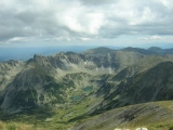
. It has its origin in the Rila Mountains in Western Bulgaria
Bulgaria
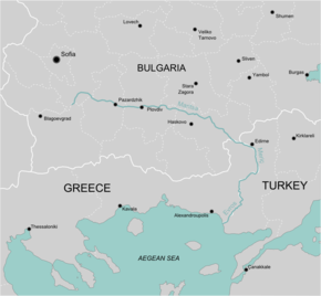
Bulgaria , officially the Republic of Bulgaria , is a parliamentary democracy within a unitary constitutional republic in Southeast Europe. The country borders Romania to the north, Serbia and Macedonia to the west, Greece and Turkey to the south, as well as the Black Sea to the east...
, flowing southeast between the Balkan and Rhodope Mountains
Rhodope Mountains
The Rhodopes are a mountain range in Southeastern Europe, with over 83% of its area in southern Bulgaria and the remainder in Greece. Its highest peak, Golyam Perelik , is the seventh highest Bulgarian mountain...
, past Plovdiv
Plovdiv
Plovdiv is the second-largest city in Bulgaria after Sofia with a population of 338,153 inhabitants according to Census 2011. Plovdiv's history spans some 6,000 years, with traces of a Neolithic settlement dating to roughly 4000 BC; it is one of the oldest cities in Europe...
and Parvomay
Parvomay
Parvomay is a town and the name of a Municipality in Southern Bulgaria. It is located in Plovdiv Province region close to the towns Sadovo and Chirpan. The English translation is sometimes given as Parvomai or Purvomai...
(where the Mechka & Kayaliyka River joins it) to Edirne
Edirne
Edirne is a city in Eastern Thrace, the northwestern part of Turkey, close to the borders with Greece and Bulgaria. Edirne served as the capital city of the Ottoman Empire from 1365 to 1453, before Constantinople became the empire's new capital. At present, Edirne is the capital of the Edirne...
, Turkey
Turkey
Turkey , known officially as the Republic of Turkey , is a Eurasian country located in Western Asia and in East Thrace in Southeastern Europe...
. A small section of the northern branch of the river runs entirely in Turkey; it was handed to Turkey in order to prevent the town of Edirne from facing a Greek bank. The rest of the river to the sea flows along the border, near Kastanies, from where it turns south to enter the Aegean Sea
Aegean Sea
The Aegean Sea[p] is an elongated embayment of the Mediterranean Sea located between the southern Balkan and Anatolian peninsulas, i.e., between the mainlands of Greece and Turkey. In the north, it is connected to the Marmara Sea and Black Sea by the Dardanelles and Bosporus...
near Enez
Enez
Enez is a district of Edirne Province, Turkey, as well as the name of the center-town of the district. Its ancient name was Aenus. The mayor is Ahmet Çayır . The population is 3,826 as of 2010....
, where it forms a delta. The Tundzha
Tundzha
The Tundzha is a river in Bulgaria and Turkey and the most significant tributary of the Maritsa, emptying into it on Turkish territory near Edirne....
is its chief tributary; the Arda
Arda River (Maritsa)
The Arda is a river whose source lies in the Bulgarian Rhodope Mountains near the town of Smolyan, flowing 290 kilometres eastward past Kardzhali and Ivaylovgrad and through Greece in the northern portion of the Evros prefecture including Kastanies. It then enters the Maritsa just west of Edirne,...
is another one. The lower course of the Maritsa/Evros forms part of the Bulgaria
Bulgaria
Bulgaria , officially the Republic of Bulgaria , is a parliamentary democracy within a unitary constitutional republic in Southeast Europe. The country borders Romania to the north, Serbia and Macedonia to the west, Greece and Turkey to the south, as well as the Black Sea to the east...
n-Greek
Greece
Greece , officially the Hellenic Republic , and historically Hellas or the Republic of Greece in English, is a country in southeastern Europe....
border and most of the Greek-Turkish
Turkey
Turkey , known officially as the Republic of Turkey , is a Eurasian country located in Western Asia and in East Thrace in Southeastern Europe...
border. The upper Maritsa valley is a principal east-west route in Bulgaria. The unnavigable river is used for power production and irrigation.
The places that the river flows through include Pazardzhik
Pazardzhik
Pazardzhik is a city situated along the banks of the Maritsa river, Southern Bulgaria. It is the capital of Pazardzhik Province and centre for the homonymous Pazardzhik Municipality...
, Plovdiv
Plovdiv
Plovdiv is the second-largest city in Bulgaria after Sofia with a population of 338,153 inhabitants according to Census 2011. Plovdiv's history spans some 6,000 years, with traces of a Neolithic settlement dating to roughly 4000 BC; it is one of the oldest cities in Europe...
, (next to) Parvomay
Parvomay
Parvomay is a town and the name of a Municipality in Southern Bulgaria. It is located in Plovdiv Province region close to the towns Sadovo and Chirpan. The English translation is sometimes given as Parvomai or Purvomai...
, through Dimitrovgrad
Dimitrovgrad, Bulgaria
Dimitrovgrad is a town in Haskovo Province, South-central Bulgaria, located close to the province capital - Haskovo. It is a newly founded settlement, built in the end of the 1940s. and named after the communist leader Georgi Dimitrov. The town is the administrative centre of the homonymous...
and Svilengrad
Svilengrad
Svilengrad is a town in Haskovo Province, South-central Bulgaria, situated at the border of Turkey and Greece. It is the administrative centre of the homonymous Svilengrad Municipality. As of December 2009, the town has a population of 18,132 inhabitants....
in Bulgaria, Edirne
Edirne
Edirne is a city in Eastern Thrace, the northwestern part of Turkey, close to the borders with Greece and Bulgaria. Edirne served as the capital city of the Ottoman Empire from 1365 to 1453, before Constantinople became the empire's new capital. At present, Edirne is the capital of the Edirne...
in Turkey and Kastanies
Kastanies
Kastanies , older form Kastania, is a town located in northern part of the peripheral unit of Evros, Greece, and is part of the municipal unit of Vyssa. It is situated by the Evros River which forms the border with Turkey.-Geography:...
, Pythio
Pythio
Pythio is a town located in the eastern part of Didymoteicho municipality. It is 16 km ENE of the centre. Turkey is located south and east of the town. The settlement is connected south and east of GR-51 and a road linking to Keşan and south to the Dardanelles. The border crossing is to the...
, Didymoteicho
Didymoteicho
Didymóteicho is a town located in the eastern part of the Evros peripheral unit of Thrace, Greece. It is the seat of the municipality of the same name. The town sits on a plain and located south east of Svilengrad, south of Edirne, Turkey and Orestiada, west of Uzunköprü, about 20 km north...
and Lavara
Lavara
Lavara is a town located in the eastern part of Evros. It was the seat of the municipality of Orfeas . It is located only 2 km from Turkey and the western banks of the Evros....
in Greece. There are a number of bridges over the river, including the one at Svilengrad
Svilengrad
Svilengrad is a town in Haskovo Province, South-central Bulgaria, situated at the border of Turkey and Greece. It is the administrative centre of the homonymous Svilengrad Municipality. As of December 2009, the town has a population of 18,132 inhabitants....
, the one west of Edirne in Turkey and GR-2
Greek National Road 2
The National Road 2 in Greece is a single carriageway with at-grade intersections in the regions of Macedonia and Thrace. It is often confused with the A2 Egnatia Odos, which is a motorway/freeway and is similarly numbered as .Parts of the road belong to european route E86....
with the D110/E90
European route E90
European route E 90 is an A-Class West-East European route, extending from Lisbon in Portugal in the west to the Turkish-Iraqi border in the east.-Itinerary:...
further south and as its border crossings.
History
In ancient times, the Maritsa was known as the Hebros.In 1371, the river was the site of the Battle of Maritsa
Battle of Maritsa
The Battle of Maritsa, or Battle of Chernomen, took place at the Maritsa River near the village of Chernomen on September 26, 1371 between the forces of the Ottoman sultan Murad I's lieutenant Lala Şâhin Paşa and the...
, also known as the battle of Chernomen, an Ottoman
Ottoman Empire
The Ottoman EmpireIt was usually referred to as the "Ottoman Empire", the "Turkish Empire", the "Ottoman Caliphate" or more commonly "Turkey" by its contemporaries...
victory over the Serbs
Serbs
The Serbs are a South Slavic ethnic group of the Balkans and southern Central Europe. Serbs are located mainly in Serbia, Montenegro and Bosnia and Herzegovina, and form a sizable minority in Croatia, the Republic of Macedonia and Slovenia. Likewise, Serbs are an officially recognized minority in...
. Vukašin Mrnjavčević
Vukašin Mrnjavcevic
Vukašin Mrnjavčević was a Serbian ruler in modern-day central and northwestern Macedonia, who ruled from 1365 to 1371. According to 17th-century Ragusan historian Mavro Orbin, his father was a minor noble named Mrnjava from Zachlumia, whose sons Vukašin and Uglješa were born in Livno in western...
and Jovan Uglješa
Jovan Ugljesa
Jovan Uglješa Mrnjavčević was a 14th-century Serbian noble and brother of Serbian ruler Vukašin Mrnjavčević.-Life:Uglješa was the son of Mrnjava, a treasurer of Helen of Anjou, the queen consort of Stephen Uroš I of Serbia....
died in the battle.
February-March 2005
On 18 February 2005, floods devastated much of the low-lying areas of the northeastern part of the Evros prefectureEvros Prefecture
Evros is one of the regional units of Greece. It is part of the region of East Macedonia and Thrace. Its name is derived from the river Evros, which appears to have been a Thracian hydronym. Evros is the northernmost regional unit. It borders Turkey to the east, across the river Evros, and it...
and the Edirne
Edirne
Edirne is a city in Eastern Thrace, the northwestern part of Turkey, close to the borders with Greece and Bulgaria. Edirne served as the capital city of the Ottoman Empire from 1365 to 1453, before Constantinople became the empire's new capital. At present, Edirne is the capital of the Edirne...
area. The flood happened when the area received above average of rainfall and snowfall which caused a dike to burst and flooded beyond its banks and as far inland as 5 to 10 km. The water levels reached as high as 6.5 m above ground, which is 10 cm above the embankment level, indicating danger to nearby residents. Pythio
Pythio
Pythio is a town located in the eastern part of Didymoteicho municipality. It is 16 km ENE of the centre. Turkey is located south and east of the town. The settlement is connected south and east of GR-51 and a road linking to Keşan and south to the Dardanelles. The border crossing is to the...
was flooded. It devastated hydrolines, train tracks and roads, damaged many farms including wheat farms and flooded many villages and houses. Many roads were closed. Teams throughout the prefecture blew up dikes in Pythio, Lavara
Lavara
Lavara is a town located in the eastern part of Evros. It was the seat of the municipality of Orfeas . It is located only 2 km from Turkey and the western banks of the Evros....
and Amorio
Amorio
There are things that have the name Amorio:*Amorio, Amori, or Amorion is a town in the prefecture of Evros, Greece*Amorion or Amorium was an ancient city in Phrygia, near modern Emirdağ, Turkey*Amorio is also a surname...
as flood control conducted 15,000 acres (61 km²) of land. The flood lasted from 17 to 22 February. Three days later, the water level dropped to 5.48 m, below the danger level of 5.70 m. The water level in the Arda dropped to 4.8 m.
Another flood which began from 1 March 2005 flooded several places again and a town which flooded a local school that has a playground leaving the basketball unflooded in Pythio. Several other buildings, roads and streets were also flooded. A day later on 2 March, the flood reached Didymoteicho
Didymoteicho
Didymóteicho is a town located in the eastern part of the Evros peripheral unit of Thrace, Greece. It is the seat of the municipality of the same name. The town sits on a plain and located south east of Svilengrad, south of Edirne, Turkey and Orestiada, west of Uzunköprü, about 20 km north...
and Lavara to the southwest. The rainfall amounts to about 5 m, 4.6 m in some areas including the Arda and as high as 6.5 m. Firemen with boats and workers were rescuing and helping people. The rail link to the northern part of Evros prefecture was closed. The flooding of the valley also flooded the Turkish side.
A third round of floods began near Edirne on the Turkish side and Kastanies
Kastanies
Kastanies , older form Kastania, is a town located in northern part of the peripheral unit of Evros, Greece, and is part of the municipal unit of Vyssa. It is situated by the Evros River which forms the border with Turkey.-Geography:...
on the Greek side on 7 March. The river was flowing at nearly 1,000 m³ per second. Kastanies became a lagoon which flooded the entire community including streets and homes and stranded people in their homes. The flood waters merged with the waters of the Arda causing it to flood Kastanies. Farmlands were underwater. The northern branch of the river also flooded houses and properties in Edirne on the Turkish side and several communities around Edirne. Workers put down sandbags to prevent the flooding of properties. The flood later reached the low lying areas of Pythio, Amorio
Amorio
There are things that have the name Amorio:*Amorio, Amori, or Amorion is a town in the prefecture of Evros, Greece*Amorion or Amorium was an ancient city in Phrygia, near modern Emirdağ, Turkey*Amorio is also a surname...
and Lavara along with Didymoteicho. The water level on 8 March was 5.8 m, 5 m at the Kiprinos Dam.
August 2005
Five months later, another flooding occurred on Thursday, 11 August 2005 in the northeastern part of the Greek prefecture of Evros between OrestiadaOrestiada
Orestiada is the northeasternmost and northernmost city of Greece and the second largest city of the Evros peripheral unit of Thrace. The population is around 25,000. Orestiada is only 2 km west of the banks of the Evros, which forms a natural border between Greece and Turkey...
and Didymoteicho, farmlands of the low-lying areas were flooded and damaged, crops including corn were completely destroyed, and the valley became a lake. The railway connecting Orestiada and Didymoteicho shut down because of the flooding of the tracks. The flood was smaller than the major 2005 flooding. One of the dikes near the river broke and caused the flooding.
March 2006
The flood waters returned in March 2006 as heavy rains with a mixture of heavy snowfalls in the Arda basin contributed to dangerous floods that flooded the low-lying areas of the Maritsa (Evros/Meriç) valley to flood villages including Kastanies, VyssaVyssa
Vyssa is a former municipality in the Evros peripheral unit, East Macedonia and Thrace, Greece. Since the 2011 local government reform it is part of the municipality Orestiada, of which it is a municipal unit. Population 8,184 . The seat of the municipality was in Nea Vyssa. It is named after a...
, Didymoteicho, Pythio, Lavara
Lavara
Lavara is a town located in the eastern part of Evros. It was the seat of the municipality of Orfeas . It is located only 2 km from Turkey and the western banks of the Evros....
, Soufli
Soufli
Soufli is a city in the Evros peripheral unit, Greece, notable for the silk industry that flourished there in the 19th century. The town stands on the eastern slope of the twin hill of Prophet Elias, one of the easternmost spurs on the Rhodope Mountains...
, near Lachyna, Tychero
Tychero
Tycheró is a town and a former municipality in the Evros peripheral unit, East Macedonia and Thrace, Greece. Since the 2011 local government reform it is part of the municipality Soufli, of which it is a municipal unit. Population 4,103 . Tychero is connected and bypassed with the GR-51/E85...
and Feres
Feres
Feres may refer to:*Feres, Evros, a town in the Evros prefecture, Greece*Feres, Magnesia, a town in the Magnesia prefecture, Greece...
in Greece and Edirne
Edirne
Edirne is a city in Eastern Thrace, the northwestern part of Turkey, close to the borders with Greece and Bulgaria. Edirne served as the capital city of the Ottoman Empire from 1365 to 1453, before Constantinople became the empire's new capital. At present, Edirne is the capital of the Edirne...
and Karaağaç in Turkey. The flood stranded people in their homes and one reporter in Lavara saw water up to the second floor of some homes, one of the dikes near these hard-hit areas flooded the area, buildings and bridges were ruined, in Turkey, flooding was slightly enough to see buildings and squares underwater, several cardboard and poorly built homes were ruined.
In Greece, one of the barns almost flooded as high as their roofs, several cows and other cattle were affected, some farms lost some cattle. Roads and railways were closed. Flood waters in the eastern part of the Greek prefecture saw water to rise over 6 m. Days later trucks and bulldozers rebuilt several dikes around the area and received help from the government to rebuilt and prevent any flood waters from entering these areas. The cause of the flood was that heavy snowfalls that amounted to record levels occurred in Bulgaria and caused its three dams to overflow in the Arda basin and flooded into the Maritsa. The flood ended a couple of days later but another low-pressure system brought rain to the areas, but it did not create any floods.
Honour
Maritsa PeakMaritsa Peak
Maritsa Peak rises to 560 m in eastern Bowles Ridge on Livingston Island in the South Shetland Islands, Antarctica. It has precipitous rocky south slopes, and is situated on the west side of Pirdop Gate, surmounting Huron Glacier to the south and Struma Glacier to the north...
on Livingston Island in the South Shetland Islands
South Shetland Islands
The South Shetland Islands are a group of Antarctic islands, lying about north of the Antarctic Peninsula, with a total area of . By the Antarctic Treaty of 1959, the Islands' sovereignty is neither recognized nor disputed by the signatories and they are free for use by any signatory for...
, Antarctica is named after Maritsa River.
La Maritza: song, authors J Renard- P. Delanoe: Singer: Sylvie Vartan, 1968
Hebrus Valles
Hebrus Valles
Hebrus Valles is an ancient system of troughs and valleys in the Amenthes quadrangle of Mars, located at 20.2° north latitude and 233.4° west longitude. It is 317 km long and was named after an ancient river in Greece...
on Mars
Mars
Mars is the fourth planet from the Sun in the Solar System. The planet is named after the Roman god of war, Mars. It is often described as the "Red Planet", as the iron oxide prevalent on its surface gives it a reddish appearance...
is named for this river.