

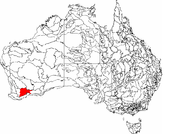
Western Mallee
Encyclopedia
Interim Biogeographic Regionalisation for Australia
The Interim Biogeographic Regionalisation for Australia is a biogeographic regionalisation of Australia developed by the Australian Government's Department of the Environment, Water, Heritage and the Arts...
(IBRA) subregion in southern Western Australia
Western Australia
Western Australia is a state of Australia, occupying the entire western third of the Australian continent. It is bounded by the Indian Ocean to the north and west, the Great Australian Bight and Indian Ocean to the south, the Northern Territory to the north-east and South Australia to the south-east...
. It is a sparsely populated subregion with an area of about 47,000 square kilometres, roughly centred on the town of Newdegate
Newdegate, Western Australia
Newdegate is a townsite in the great southern agricultural region, 399 km south-east of Perth and 52 km east of Lake Grace in Western Australia. The townsite was gazetted in 1925 and honours Sir Francis Newdegate, the Governor of Western Australia from 1920 to 1924...
. Largely cleared for intensive agriculture, it still retains patches of native vegetation, but these are under environmental stress from threats such as rising salinity
Salinity in Australia
Soil salinity and dryland salinity are two problems degrading the environment of Australia. Salinity is a concern in most states, but especially in the south-west of Western Australia....
, and are poorly managed.
Geography
Mallee (biogeographic region)
Mallee, also known as Roe Botanical District, is a biogeographic region in southern Western Australia. Located between the Esperance Plains, Avon Wheatbelt and Coolgardie regions, it has a low, gently undulating topography, a semi-arid mediterranean climate, and extensive Eucalyptus mallee...
biogeographic region. It has an area of 47,636 square kilometres, which is only lightly populated. The main towns are Hyden
Hyden, Western Australia
The town of Hyden is located 339 km east of Perth, Western Australia in the Shire of Kondinin. Hyden is home to Wave Rock and Mulka's Cave, both popular local tourist attractions....
, Gnowangerup
Gnowangerup, Western Australia
Gnowangerup is a town located south east of Katanning in the Great Southern region of Western Australia. The townsite was first gazetted in 1908 under the spelling of Ngowangerupp. Local dissatisfaction with this spelling led to it being altered to Gnowangerup in 1913.A branch railway from...
and Lake Grace
Lake Grace, Western Australia
-Natural disasters:In late 2005 and early 2006, Lake Grace experienced two natural disasters. The first was a hail storm on 16 October 2005, which destroyed 500 hectares of wheat and barley crop and damaged a further 5,500 hectares, with some farmers reporting fields covered by up to...
; lesser towns include Kulin
Kulin, Western Australia
Kulin is a town located in the Eastern Wheatbelt region of Western Australia, approximately 280 km from Perth. It is the main town in the Shire of Kulin.- History :...
, Ongerup
Ongerup, Western Australia
Ongerup is a town located 410 km south-east of Perth and 54 km east of Gnowangerup in the Great Southern region of Western Australia.- History :The name Ongerup means Place of the male kangaroo in the local Noongar language....
, Duggan, Newdegate
Newdegate, Western Australia
Newdegate is a townsite in the great southern agricultural region, 399 km south-east of Perth and 52 km east of Lake Grace in Western Australia. The townsite was gazetted in 1925 and honours Sir Francis Newdegate, the Governor of Western Australia from 1920 to 1924...
, Lake King
Lake King, Western Australia
Lake King is a town located in the Eastern Wheatbelt region of Western Australia, from Perth along State Route 107 between Wagin and Ravensthorpe....
and Kondinin
Kondinin, Western Australia
Kondinin is a town located in the Eastern Wheatbelt region of Western Australia, east of the state capital, Perth via the Brookton Highway and State Route 40 between Corrigin and Hyden. It is the main town in the Shire of Kondinin...
.
The subregion contains a number of ecologically important freshwater wetlands, including the Lake Bryde-East Lake Bryde
Lake Bryde-East Lake Bryde
Lake Bryde-East Lake Bryde is a DIWA-listed freshwater wetland system in Western Australia. It is located at , in the Shire of Kent, 34 kilometres south-west of Newdegate...
wetlands, a DIWA Wetland of National Significance and habitat for a critically endangered
Critically endangered
Version 2010.3 of the IUCN Red List of Threatened Species identified 3744 Critically Endangered species, subspecies and varieties, stocks and subpopulations.Critically Endangered by kingdom:*1993 Animalia*2 Fungi*1745 Plantae*4 Protista-References:...
threatened ecological community
Threatened ecological community
Threatened ecological community is a term used in Australia for ecosystems that are in danger of being lost due to some threatening process. Federally, threatened ecological communities are identified and protected under the Environment Protection and Biodiversity Conservation Act 1999. Some states...
of shrub lake beds; the Lake Grace system of wetlands, also a DIWA Wetland of National Significance; and the Lake Cronin system.
Geology
Western Mallee is situated on south-eastern parts of the Yilgarn CratonYilgarn craton
The Yilgarn Craton is a large craton which constitutes the bulk of the Western Australian land mass. It is bounded by a mixture of sedimentary basins and Proterozoic fold and thrust belts...
. It has a gently undulating landscape, with somewhat more relief than eastern parts of the Mallee region. There are a variety of soils, including clay
Clay
Clay is a general term including many combinations of one or more clay minerals with traces of metal oxides and organic matter. Geologic clay deposits are mostly composed of phyllosilicate minerals containing variable amounts of water trapped in the mineral structure.- Formation :Clay minerals...
s and silt
Silt
Silt is granular material of a size somewhere between sand and clay whose mineral origin is quartz and feldspar. Silt may occur as a soil or as suspended sediment in a surface water body...
s over kankar
Kankar
Kankar is a sedimentological term derived from Hindi occasionally applied in India and the United States to detrital or residual rolled, often nodular calcium carbonate formed in soils of semi-arid regions....
; sand
Sand
Sand is a naturally occurring granular material composed of finely divided rock and mineral particles.The composition of sand is highly variable, depending on the local rock sources and conditions, but the most common constituent of sand in inland continental settings and non-tropical coastal...
; lateritic pavements
Laterite
Laterites are soil types rich in iron and aluminium, formed in hot and wet tropical areas. Nearly all laterites are rusty-red because of iron oxides. They develop by intensive and long-lasting weathering of the underlying parent rock...
; and granite outcrops
Granite outcrops of Western Australia
Granite outcrops of Western Australia are inselbergs and monoliths made from granite that are found across much of Western Australia. Rising abruptly from the surrounding landscape they create a variety of microhabitats for plants, and provide seasonal resources and refuge for a range of animals....
. Gypsum
Gypsum
Gypsum is a very soft sulfate mineral composed of calcium sulfate dihydrate, with the chemical formula CaSO4·2H2O. It is found in alabaster, a decorative stone used in Ancient Egypt. It is the second softest mineral on the Mohs Hardness Scale...
dune
Dune
In physical geography, a dune is a hill of sand built by wind. Dunes occur in different forms and sizes, formed by interaction with the wind. Most kinds of dunes are longer on the windward side where the sand is pushed up the dune and have a shorter "slip face" in the lee of the wind...
s also occur in the area. The subregion has occluded drainage
Drainage
Drainage is the natural or artificial removal of surface and sub-surface water from an area. Many agricultural soils need drainage to improve production or to manage water supplies.-Early history:...
, with a number of lakes, both saline and fresh.
Climate
Western Mallee is semi-arid, with a warm, dry, Mediterranean climateMediterranean climate
A Mediterranean climate is the climate typical of most of the lands in the Mediterranean Basin, and is a particular variety of subtropical climate...
. It has seven to eight dry months, and a winter rainfall typically between 250 and 500 millimetres (10–19 in).
| Jan | Feb | Mar | Apr | May | Jun | Jul | Aug | Sep | Oct | Nov | Dec | Year | ||
|---|---|---|---|---|---|---|---|---|---|---|---|---|---|---|
| Mean daily maximum temperature |
33.5°C Celsius Celsius is a scale and unit of measurement for temperature. It is named after the Swedish astronomer Anders Celsius , who developed a similar temperature scale two years before his death... 92.3°F Fahrenheit Fahrenheit is the temperature scale proposed in 1724 by, and named after, the German physicist Daniel Gabriel Fahrenheit . Within this scale, the freezing of water into ice is defined at 32 degrees, while the boiling point of water is defined to be 212 degrees... |
32.8°C 91.0°F |
29.8°C 85.6°F |
25.5°C 77.9°F |
20.6°C 69.1°F |
17.2°C 63.0°F |
16.3°C 61.3°F |
17.3°C 63.1°F |
20.2°C 68.4°F |
24.4°C 75.9°F |
28.2°C 82.8°F |
31.9°C 89.4°F |
24.8°C 76.6°F |
|
| Mean daily minimum temperature | 15.3°C 59.5°F |
15.7°C 60.3°F |
14.1°C 57.4°F |
11.1°C 52.0°F |
7.7°C 45.9°F |
5.7°C 42.3°F |
4.7°C 40.5°F |
4.7°C 40.5°F |
5.9°C 42.6°F |
8.1°C 46.6°F |
11.4°C 52.5°F |
13.8°C 56.8°F |
9.9°C 49.8°F |
|
| Mean total rainfall | 19.4 mm Millimetre The millimetre is a unit of length in the metric system, equal to one thousandth of a metre, which is the SI base unit of length.... 0.76 in Inch An inch is the name of a unit of length in a number of different systems, including Imperial units, and United States customary units. There are 36 inches in a yard and 12 inches in a foot... |
19.9 mm 0.78 in |
20.6 mm 0.81 in |
24.6 mm 0.97 in |
40.2 mm 1.58 in |
51.2 mm 2.02 in |
47.1 mm 1.85 in |
41.2 mm 1.62 in |
27.6 mm 1.09 in |
20.8 mm 0.82 in |
17.7 mm 0.70 in |
13.5 mm 0.53 in |
334.9 mm 13.19 in |
|
| Mean number of rain days | 2.2 | 2.1 | 2.2 | 3.4 | 5.9 | 8.2 | 9.0 | 7.7 | 5.6 | 3.9 | 2.8 | 2.1 | 55.1 | |
| Source: Bureau of Meteorology | ||||||||||||||
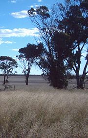
Vegetation

Mallee (habit)
Mallee is the growth habit of certain eucalypt species that grow with multiple stems springing from an underground lignotuber, usually to a height of no more than ten metres...
communities consisting primarily of Eucalyptus
Eucalyptus
Eucalyptus is a diverse genus of flowering trees in the myrtle family, Myrtaceae. Members of the genus dominate the tree flora of Australia...
species. Sands and laterites support scrub-heath of Myrtaceae
Myrtaceae
The Myrtaceae or Myrtle family are a family of dicotyledon plants, placed within the order Myrtales. Myrtle, clove, guava, feijoa, allspice, and eucalyptus belong here. All species are woody, with essential oils, and flower parts in multiples of four or five...
and Proteaceae
Proteaceae
Proteaceae is a family of flowering plants distributed in the Southern Hemisphere. The family comprises about 80 genera with about 1600 species. Together with the Platanaceae and Nelumbonaceae they make up the order Proteales. Well known genera include Protea, Banksia, Embothrium, Grevillea,...
, and the finer-textured soils support Eucalyptus woodland
Woodland
Ecologically, a woodland is a low-density forest forming open habitats with plenty of sunlight and limited shade. Woodlands may support an understory of shrubs and herbaceous plants including grasses. Woodland may form a transition to shrubland under drier conditions or during early stages of...
s; the latter have a particularly high diversity of flora, of which around 25% is rare. Granite outcrops also support a characteristic vegetation.
There are also a number of vegetation communities of lesser extent, including some that are considered endangered or at risk. Most notable is the critically endangered
Critically endangered
Version 2010.3 of the IUCN Red List of Threatened Species identified 3744 Critically Endangered species, subspecies and varieties, stocks and subpopulations.Critically Endangered by kingdom:*1993 Animalia*2 Fungi*1745 Plantae*4 Protista-References:...
community of Muehlenbeckia horrida subsp. abdita
Muehlenbeckia horrida subsp. abdita
Muehlenbeckia horrida subsp. abdita, commonly known as Remote Thorny Lignum, is a critically endangered shrub endemic to Western Australia.-Description:...
and Tecticornia verrucosa that occurs on the lake beds of the Lake Bryde-East Lake Bryde
Lake Bryde-East Lake Bryde
Lake Bryde-East Lake Bryde is a DIWA-listed freshwater wetland system in Western Australia. It is located at , in the Shire of Kent, 34 kilometres south-west of Newdegate...
wetland
Wetland
A wetland is an area of land whose soil is saturated with water either permanently or seasonally. Wetlands are categorised by their characteristic vegetation, which is adapted to these unique soil conditions....
system. Gypsum dunes support a vulnerable
Vulnerable species
On 30 January 2010, the IUCN Red List of Threatened Species identified 9694 Vulnerable species, subspecies and varieties, stocks and sub-populations.-References:...
ecological community of herblands and bunch grasslands, and an at-risk community of Eucalyptus
Eucalyptus
Eucalyptus is a diverse genus of flowering trees in the myrtle family, Myrtaceae. Members of the genus dominate the tree flora of Australia...
aff. incrassata over low scrub; at least 80 plant species are likely to occur only on gypsum dunes, including several threatened species. Some plant communities of the Bremer Range are also considered vulnerable.
Flora and fauna
Information on Western Mallee's flora and fauna is scarce, as the area has not had a thorough biodiversity survey. What information is available has been gathered in the context of conservation assessment:The subregion contains many endemic plant species in the Eucalyptus
Eucalyptus
Eucalyptus is a diverse genus of flowering trees in the myrtle family, Myrtaceae. Members of the genus dominate the tree flora of Australia...
, Acacia
Acacia
Acacia is a genus of shrubs and trees belonging to the subfamily Mimosoideae of the family Fabaceae, first described in Africa by the Swedish botanist Carl Linnaeus in 1773. Many non-Australian species tend to be thorny, whereas the majority of Australian acacias are not...
, Proteaceae
Proteaceae
Proteaceae is a family of flowering plants distributed in the Southern Hemisphere. The family comprises about 80 genera with about 1600 species. Together with the Platanaceae and Nelumbonaceae they make up the order Proteales. Well known genera include Protea, Banksia, Embothrium, Grevillea,...
such as Grevillea
Grevillea
Grevillea is a diverse genus of about 360 species of evergreen flowering plants in the protea family Proteaceae, native to Australia, New Guinea, New Caledonia, and Sulawesi. It was named in honour of Charles Francis Greville. The species range from prostrate shrubs less than 0.5 m tall to trees...
, Hakea
Hakea
Hakea is a genus of 149 species of shrubs and small trees in the Proteaceae, native to Australia. They are found throughout the country, with the highest species diversity being found in the south west of Western Australia....
and Banksia
Banksia
Banksia is a genus of around 170 species in the plant family Proteaceae. These Australian wildflowers and popular garden plants are easily recognised by their characteristic flower spikes and fruiting "cones" and heads. When it comes to size, banksias range from prostrate woody shrubs to trees up...
; and various Asteraceae
Asteraceae
The Asteraceae or Compositae , is an exceedingly large and widespread family of vascular plants. The group has more than 22,750 currently accepted species, spread across 1620 genera and 12 subfamilies...
. It contains numerous rare, endangered and priority flora. It also supports a number of rare or endangered fauna, including some that fall within the critical weight range for predation
Predation
In ecology, predation describes a biological interaction where a predator feeds on its prey . Predators may or may not kill their prey prior to feeding on them, but the act of predation always results in the death of its prey and the eventual absorption of the prey's tissue through consumption...
by fox
Fox
Fox is a common name for many species of omnivorous mammals belonging to the Canidae family. Foxes are small to medium-sized canids , characterized by possessing a long narrow snout, and a bushy tail .Members of about 37 species are referred to as foxes, of which only 12 species actually belong to...
es. The Pig-footed Bandicoot
Pig-footed Bandicoot
The Pig-footed Bandicoot, Chaeropus ecaudatus, was a small marsupial of the arid and semi-arid plains of Australia. The distribution range of the species was later reduced to an inland desert region, where it was last recorded in the 1950s, and is now presumed to be extinct.-Classification:This...
(Chaeropus ecaudatus) and Crescent Nailtail Wallaby (Onychogalea lunata) previously occurred in the subregion, but both are now extinct. The Rufous Hare-wallaby
Rufous Hare-wallaby
The rufous hare-wallaby , also known as the Mala, is a small macropod found in Australia. It was formerly widely distributed across the western half of the continent but is now confined to Bernier Island and Dorre Island Islands off Western Australia...
(Lagorchestes hirsutus) is now extinct in the wild, and a further ten species of mammal are extinct in the subregion. The endangered Red-tailed Phascogale
Red-tailed Phascogale
The Red-tailed Phascogale , also known as the Red-tailed Wambenger, is a small carnivorous marsupial found in central and western Australia...
(Phascogale calura) still occurs in the region, as do the vulnerable Black-flanked Rock-wallaby
Black-flanked Rock-wallaby
The Black-flanked Rock-wallaby , also known as the Black-footed Rock-wallaby or Warru, is a kind of wallaby, one of several rock-wallabies in the genus Petrogale.-Description:...
(Petrogale lateralis) and Heath Rat (Pseudomys shortridgei), and the Western Brush Wallaby
Western Brush Wallaby
The Western Brush Wallaby , also known as the Black-gloved Wallaby, is a species of wallaby found in southwestern Western Australia. The main threat towards it seems to be predation by the introduced Red Fox...
(Macropus irma).
Land use
Around 10% of the subregion is held within nature reserve
Nature reserve
A nature reserve is a protected area of importance for wildlife, flora, fauna or features of geological or other special interest, which is reserved and managed for conservation and to provide special opportunities for study or research...
s for conservation purposes, covering about 25% of the remaining vegetation. There is also a small amount of gypsum
Gypsum
Gypsum is a very soft sulfate mineral composed of calcium sulfate dihydrate, with the chemical formula CaSO4·2H2O. It is found in alabaster, a decorative stone used in Ancient Egypt. It is the second softest mineral on the Mohs Hardness Scale...
mining, and a tourist industry centred on Wave Rock
Wave Rock
Wave Rock is a natural rock formation located east of the small town of Hyden in Western Australia that is shaped like a tall breaking ocean wave.Wave Rock has cultural significance to Aborigines...
near Hyden. The subregion contains populations of Eucalyptus
Eucalyptus
Eucalyptus is a diverse genus of flowering trees in the myrtle family, Myrtaceae. Members of the genus dominate the tree flora of Australia...
and Melaleuca
Melaleuca
Melaleuca is a genus of plants in the myrtle family Myrtaceae known for its natural soothing and cleansing properties. There are well over 200 recognised species, most of which are endemic to Australia...
species that produce commercial quantities of cineole oil, so in future the subregion is likely to support a plantation-based oil mallee industry, at least as a source of breeding material if not also land.
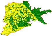
The subregion's nature reserves are poorly managed. Little information is available for management purposes, as the subregion has not had a thorough biodiversity survey, vegetation mapping is available only at 1:250,000 scale, and there are virtually no historical records of fires or other significant events. Other than routine baiting of foxes in some reserves, there is little done to manage threats. The main threat, rising salinity, is completely unmanaged, despite having already caused widespread population declines and extinctions in lowland communities.
The subregion was given a Continental Stress Class
Continental Stress Class
Continental Stress Class is a method of describing the landscape health of biogeographic regions in Australia. There are six Continental Stress Classes with Class 1 containing the most stressed regions and Class 6 the least stressed and therefore most healthy...
of 3 when measured against the criteria, but the authors of that assessment stated that it should more properly be rated at 2 or even 1, because of the poor connectivity of reserves within cleared areas.
Biogeography
Western Mallee was introduced in IBRA Version 6.1. Its region code is MAL2. It is one of two subregions of the MalleeMallee (biogeographic region)
Mallee, also known as Roe Botanical District, is a biogeographic region in southern Western Australia. Located between the Esperance Plains, Avon Wheatbelt and Coolgardie regions, it has a low, gently undulating topography, a semi-arid mediterranean climate, and extensive Eucalyptus mallee...
region, the other being Eastern Mallee
Eastern Mallee
Eastern Mallee is an Interim Biogeographic Regionalisation for Australia subregion in southern Western Australia.-Geography:Eastern Mallee is roughly defined as the eastern half of the Mallee biogeographic region. It has an area of around 46,000 square kilometres, and is very sparsely populated....
. The Mallee, Avon Wheatbelt
Avon Wheatbelt
Avon Wheatbelt is an Interim Biogeographic Regionalisation for Australia region in Western Australia and part of the larger Southwest Australia savanna ecoregion.-Further reading:...
and Geraldton Sandplains
Geraldton Sandplains
Geraldton Sandplains is an Interim Biogeographic Regionalisation for Australia region in Western Australia and part of the larger Southwest Australia savanna ecoregion.It has two sub regions: -* Geraldton Hills sub region* Lesuer sub region...
regions together comprise Hopper
Stephen Hopper
Stephen Donald Hopper is a Western Australian botanist, specialising in conservation biology and vascular plants. He has written eight books, and has over 200 publications to his name. He was Director of Kings Park in Perth for seven years, and CEO of the Botanic Gardens and Parks Authority for five...
's Transitional Rainfall Zone
Transitional Rainfall Zone
The Transitional Rainfall Zone is one of three biogeographic zones into which south west Western Australia is divided, the others being the High Rainfall Zone and the Low Rainfall Zone...
of Beard
John Stanley Beard
John Stanley Beard was a British-born forester and ecologist who resided in Australia. While working with the Forestry Division in Trinidad and Tobago during the 1940s, Beard developed a system of forest classification for Tropical America and described the forests of Trinidad, Tobago, and the...
's South West Botanical Province.
Under the World Wide Fund for Nature
World Wide Fund for Nature
The World Wide Fund for Nature is an international non-governmental organization working on issues regarding the conservation, research and restoration of the environment, formerly named the World Wildlife Fund, which remains its official name in Canada and the United States...
's regionalisation of the world's terrestrial surface into "ecoregions", the Western Mallee subregion falls within the Esperance Mallee
Esperance mallee
Esperance Mallee is a World Wide Fund for Nature ecoregion on the south coast of Western Australia, a coastal strip where the predominant vegetation consists of short eucalyptus trees and shrubs.-Location and description:...
ecoregion, one of 6 ecoregions comprising the Southwest Australia
Southwest Australia
Southwest Australia is a biodiversity hotspot that includes the Mediterranean forests, woodlands, and scrub ecoregions of Western Australia. The region has a wet-winter, dry-summer Mediterranean climate, one of five such regions in the world...
ecozone.
Further reading
- Thackway, R and I D Cresswell (1995) An interim biogeographic regionalisation for Australia : a framework for setting priorities in the National Reserves System Cooperative Program Version 4.0 Canberra : Australian Nature Conservation Agency, Reserve Systems Unit, 1995. ISBN 0642213712