
.gif)
M-20 (Michigan highway)
Encyclopedia
M-20 is a state trunkline highway
in the US state of Michigan
that runs from New Era
to Midland
. It crosses through rural Lower Peninsula
forest land between the two ends. The highway serves the college towns of Big Rapids
and Mt. Pleasant, home of the main campuses of Ferris State University
and Central Michigan University
, both located near the trunkline.
Originally in July 1919, M-20 was routed farther north along a corridor now used by US Highway 10
(US 10). The M-20 designation was shifted south to the corridor it now follows. It previously connected to Bay City
, and in 1958, a freeway was opened from Bay City to Midland. The former M-20 along Midland Road, going through Auburn
, was returned to local control at that time. In 1960, the M-20 freeway became US 10, moving M-20's terminus to Midland. Prior to 1969, M-20 extended on the west end to Muskegon
before it was rerouted from White Cloud
to New Era.
at the US 31
freeway in New Era where it runs east through the Manistee National Forest, crossing the North Branch of the White River near Ferry and the South Branch near Hesperia
on the way to White Cloud
. There it turns south along M-37
and then east along a new routing following Baseline and Newcosta roads north of the Hardy Dam
to meet the US 131
freeway at exit 131 near Stanwood
. M-20 turns north, running concurrently
along the US 131 freeway to Big Rapids
and joins Business US 131 (BUS US 131) at exit 139. The section along the freeway is listed on the National Highway System
(NHS), a system of highways important to the nation's economy, defense and mobility. Together BUS US 131/M-20 runs along the Perry Street commercial corridor to State Street near the main campus of Ferris State University
. The business loop turns north by the campus and at Michigan Street, M-20 turns eastward to cross the Muskegon River
in downtown Big Rapids, north of the campus. M-20 zig-zags southeast of town bypassing the Canadian Lakes
area and turns due east through rural Remus in Isabella County
and the Isabella Indian Reservation
.
In Mt. Pleasant, M-20 runs near the campus of Central Michigan University
crossing the Chippewa River
, and the trunkline joins BUS US 127 along the Mission Street business area to Pickard Road. The highway turns turns east on Pickard and passes under the US 127
freeway near the Soaring Eagle Casino
. From Mt. Pleasant to Midland
, M-20 is designed as a four–lane highway with a continuous center turn lane passing through rural forest land. M-20 picks up inclusion on the NHS from this point east.
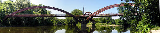
Once M-20 reaches Midland on Jerome Street, it crosses the Tittabawassee River
north of the Tridge
, a three-legged bridge over the confluence of the Tittabawassee and Chippewa rivers. There it joins Business US 10 (BUS US 10) on a pair of one-way streets
: Indian Street (westbound) and Buttles Street (eastbound). The two streets pass by Dow Diamond, home to the Great Lakes Loons
, the city's minor league baseball
team. BUS US 10/M-20 then passes some Dow Chemical Company
buildings and curves into a freeway stub connecting with the US 10 freeway on the east side of town. This short section of business loop freeway has two interchanges
before terminating at one final interchange. At this junction, both BUS US 10 and M-20 have a common eastern terminus. Traffic headed eastbound on the business loop defaults onto eastbound US 10, and traffic destined for the business loop is fed from the westbound direction of the freeway only.
to Bay City, Michigan
by way of Reed City
and Clare
. This routing was redesignated as US 10 on November 11, 1926. M-20 would be moved to a new routing.
. The western terminus was extended to end at Muskegon State Park
in 1932. The last paving would be completed along M-20 in 1957 in Newaygo County
.
The eastern end of M-20 was converted to freeway between Midland and Bay City in 1958. The former alignment along Midland Road, from Midland, going through Auburn, and ending at Euclid Avenue in Bay City, at the junction of what was then US 23
, was returned to local control at the time. US 10 was rerouted along this freeway section and the I-75
/US 23 freeway in 1960. M-20 was truncated back to Midland with the US 10 rerouting. The west end was rerouted through Muskegon to end at US 16 in 1961. The former routing connecting to Muskegon State Park became a new M-213 until it was removed from the trunkline system in 1970. M-20 was completely rerouted on the west end in 1969 from White Cloud
replacing M-82
to US 31 in New Era.
The Michigan Department of Transportation
(MDOT) swapped jurisdiction of M-20 and B-88 with Mecosta
and Newaygo
counties. The swap was finalized on October 1, 1998. M-20 was rerouted south from Big Rapids, along US 131 from exit 139 to exit 131 at Stanwood
. There M-20 replaced B-88 westward to M-37
.
Michigan Highway System
The Michigan State Trunkline Highway System is made up of all the highways designated as Interstates, U.S. Highways and State Highways in the US state of Michigan. The system is maintained by the Michigan Department of Transportation and comprises of trunklines in all 83 counties of Michigan on...
in the US state of Michigan
Michigan
Michigan is a U.S. state located in the Great Lakes Region of the United States of America. The name Michigan is the French form of the Ojibwa word mishigamaa, meaning "large water" or "large lake"....
that runs from New Era
New Era, Michigan
New Era is a village in Shelby Township, Oceana County in the U.S. state of Michigan. The population was 461 at the 2000 census.New Era is the birthplace of Caldecott Medal-winning children's author Verna Aardema...
to Midland
Midland, Michigan
Midland is a city in the U.S. state of Michigan in the Tri-Cities region of the state. It is the county seat of Midland County. The city's population was 41,863 as of the 2010 census. It is the principal city of the Midland Micropolitan Statistical Area....
. It crosses through rural Lower Peninsula
Lower Peninsula of Michigan
The Lower Peninsula of Michigan is the southern of the two major landmasses of the U.S. state of Michigan. It is surrounded by water on all sides except its southern border, which it shares with Ohio and Indiana. Geographically, the Lower Peninsula has a recognizable shape that many people...
forest land between the two ends. The highway serves the college towns of Big Rapids
Big Rapids, Michigan
Big Rapids is a city in the U.S. state of Michigan. As of the 2000 census, the city population was 10,849. It is the county seat of Mecosta County. The city is located within Big Rapids Township, but is politically independent.-Geography:...
and Mt. Pleasant, home of the main campuses of Ferris State University
Ferris State University
Ferris State University is a public university with its main campus in Big Rapids, Michigan, USA. Founded in 1884 as the Big Rapids Industrial School by Woodbridge Nathan Ferris, an educator from New England who later served as governor of the State of Michigan and finally in the US Senate where...
and Central Michigan University
Central Michigan University
Central Michigan University is a public research university located in Mount Pleasant in the U.S. state of Michigan...
, both located near the trunkline.
Originally in July 1919, M-20 was routed farther north along a corridor now used by US Highway 10
U.S. Route 10 in Michigan
US Highway 10 is a part of the United States Numbered Highway System that runs from West Fargo, North Dakota, to the Lower Peninsula of the US state of Michigan. The highway enters the state on the SS Badger crossing Lake Michigan at Ludington and ends at Bay City.US 10 was created as part of...
(US 10). The M-20 designation was shifted south to the corridor it now follows. It previously connected to Bay City
Bay City, Michigan
Bay City is a city in the U.S. state of Michigan located near the base of the Saginaw Bay on Lake Huron. As of the 2010 census, the city's population was 34,932, and is the principal city of the Bay City Metropolitan Statistical Area, which is included in the Saginaw-Bay City-Saginaw Township North...
, and in 1958, a freeway was opened from Bay City to Midland. The former M-20 along Midland Road, going through Auburn
Auburn, Michigan
Auburn is a city in Bay County in the U.S. state of Michigan. The city's population was 2,011 at the 2000 census. It is included in the Bay City, Michigan Metropolitan Statistical Area...
, was returned to local control at that time. In 1960, the M-20 freeway became US 10, moving M-20's terminus to Midland. Prior to 1969, M-20 extended on the west end to Muskegon
Muskegon, Michigan
Muskegon is a city in the U.S. state of Michigan. As of the 2010 census, the city population was 38,401. The city is the county seat of Muskegon County...
before it was rerouted from White Cloud
White Cloud, Michigan
White Cloud is a city in the U.S. state of Michigan. As of the 2010 census, the city population was 1,408. It is the county seat of Newaygo County.-Geography:...
to New Era.
Route description
M-20 starts near Lake MichiganLake Michigan
Lake Michigan is one of the five Great Lakes of North America and the only one located entirely within the United States. It is the second largest of the Great Lakes by volume and the third largest by surface area, after Lake Superior and Lake Huron...
at the US 31
U.S. Route 31 in Michigan
US Highway 31 is a part of the United States Numbered Highway System that runs from Alabama, to the Upper Peninsula of the US state of Michigan. In Michigan, it is a state trunkline highway that runs from the Indiana–Michigan state line at Bertrand Township to its terminus at Interstate 75 south...
freeway in New Era where it runs east through the Manistee National Forest, crossing the North Branch of the White River near Ferry and the South Branch near Hesperia
Hesperia, Michigan
Hesperia is a village in Newaygo and Oceana counties in the U.S. state of Michigan. About half of the village lies in Newfield Township in Oceana County and half in Denver Township in Newaygo County...
on the way to White Cloud
White Cloud, Michigan
White Cloud is a city in the U.S. state of Michigan. As of the 2010 census, the city population was 1,408. It is the county seat of Newaygo County.-Geography:...
. There it turns south along M-37
M-37 (Michigan highway)
M-37 is a north–south state trunkline highway in the US state of Michigan. The southern terminus is near the border between Kalamazoo and Calhoun counties at exit 92 of Interstate 94 southwest of Battle Creek. The northern terminus is at the Mission Point Light on Old Mission Point in Grand...
and then east along a new routing following Baseline and Newcosta roads north of the Hardy Dam
Hardy Dam
Hardy Dam is a dam and powerplant complex on the Muskegon River in Big Prairie Township, Newaygo County, Michigan. At the time of its completion, it was the largest earthen dam in North America east of the Mississippi, and is still the third largest earthen dam in the world and the largest east of...
to meet the US 131
U.S. Route 131
US Highway 131 is a north–south United States Highway, of which all but 0.67 miles of its 266.82 miles are within the state of Michigan. The highway starts in rural Indiana south of the state line as a state road connection to the Indiana Toll Road...
freeway at exit 131 near Stanwood
Stanwood, Michigan
Stanwood is a village in Mecosta County of the U.S. state of Michigan. As of the 2000 census, the village population was 204. The village is within Mecosta Township.-Geography:...
. M-20 turns north, running concurrently
Concurrency (road)
A concurrency, overlap, or coincidence in a road network is an instance of one physical road bearing two or more different highway, motorway, or other route numbers...
along the US 131 freeway to Big Rapids
Big Rapids, Michigan
Big Rapids is a city in the U.S. state of Michigan. As of the 2000 census, the city population was 10,849. It is the county seat of Mecosta County. The city is located within Big Rapids Township, but is politically independent.-Geography:...
and joins Business US 131 (BUS US 131) at exit 139. The section along the freeway is listed on the National Highway System
National Highway System (United States)
The National Highway System is a network of strategic highways within the United States, including the Interstate Highway System and other roads serving major airports, ports, rail or truck terminals, railway stations, pipeline terminals and other strategic transport facilities.Individual states...
(NHS), a system of highways important to the nation's economy, defense and mobility. Together BUS US 131/M-20 runs along the Perry Street commercial corridor to State Street near the main campus of Ferris State University
Ferris State University
Ferris State University is a public university with its main campus in Big Rapids, Michigan, USA. Founded in 1884 as the Big Rapids Industrial School by Woodbridge Nathan Ferris, an educator from New England who later served as governor of the State of Michigan and finally in the US Senate where...
. The business loop turns north by the campus and at Michigan Street, M-20 turns eastward to cross the Muskegon River
Muskegon River
The Muskegon River is a river in the western portion of the lower peninsula of the U.S. state of Michigan. The river has its headwaters in Houghton Lake in Roscommon County, flowing out of the North Bay into neighboring Missaukee County. From there it flows mostly southwest to Muskegon, Michigan,...
in downtown Big Rapids, north of the campus. M-20 zig-zags southeast of town bypassing the Canadian Lakes
Canadian Lakes, Michigan
Canadian Lakes is an unincorporated resort community in Mecosta County in the U.S. state of Michigan. The area is mostly within the southwest portion of Morton Township, southwest of Mecosta and east of Stanwood....
area and turns due east through rural Remus in Isabella County
Isabella County, Michigan
-Demographics:As of the census of 2000, there were 63,351 people, 22,425 households, and 13,006 families residing in the county. The population density was 110 people per square mile . There were 24,528 housing units at an average density of 43 per square mile...
and the Isabella Indian Reservation
Isabella Indian Reservation
The Isabella Indian Reservation is the land base of the Saginaw Chippewa Tribal Council, located in Isabella County in the central part of the U.S. state of Michigan. There are also some small parcels of off-reservation trust land in Standish Township, Arenac County, near Saginaw Bay, southeast of...
.
In Mt. Pleasant, M-20 runs near the campus of Central Michigan University
Central Michigan University
Central Michigan University is a public research university located in Mount Pleasant in the U.S. state of Michigan...
crossing the Chippewa River
Chippewa River (Michigan)
The Chippewa River is a stream in the U.S. state of Michigan that runs through the central Lower Peninsula. The Chippewa is a tributary of the Tittabawassee River and is thus part of the Saginaw River drainage basin...
, and the trunkline joins BUS US 127 along the Mission Street business area to Pickard Road. The highway turns turns east on Pickard and passes under the US 127
U.S. Route 127 in Michigan
US Highway 127 is a part of the United States Numbered Highway System that runs from Chattanooga, Tennessee, to the Lower Peninsula of the US state of Michigan. In Michigan, it is a state trunkline highway that runs for , entering from Ohio south of Hudson and ending at a partial interchange with...
freeway near the Soaring Eagle Casino
Soaring Eagle Casino
The Soaring Eagle Casino and Resort is a casino, hotel and entertainment venue owned and operated by the Saginaw Chippewa Indian Tribe, located just outside of Mt. Pleasant, Michigan. It is considered to be the largest casino in the Midwest...
. From Mt. Pleasant to Midland
Midland, Michigan
Midland is a city in the U.S. state of Michigan in the Tri-Cities region of the state. It is the county seat of Midland County. The city's population was 41,863 as of the 2010 census. It is the principal city of the Midland Micropolitan Statistical Area....
, M-20 is designed as a four–lane highway with a continuous center turn lane passing through rural forest land. M-20 picks up inclusion on the NHS from this point east.
Once M-20 reaches Midland on Jerome Street, it crosses the Tittabawassee River
Tittabawassee River
The Tittabawassee River is a stream which flows in a generally southeasterly direction through the Lower Peninsula of the U.S. state of Michigan. The river begins at Secord Lake in Clement Township, at the confluence of the East Branch and the Middle Branch...
north of the Tridge
The Tridge
The Tridge is the formal name of a three-way footbridge above the confluence of the Chippewa and Tittabawassee Rivers near downtown Midland, Michigan, in the Tri-Cities. The bridge was constructed in 1981 at a cost of $732,000 and took 6,400 hours of labor....
, a three-legged bridge over the confluence of the Tittabawassee and Chippewa rivers. There it joins Business US 10 (BUS US 10) on a pair of one-way streets
One-way traffic
One-way traffic is traffic that moves in a single direction. A one-way street is a street either facilitating only one-way traffic, or designed to direct vehicles to move in one direction.-General signs:...
: Indian Street (westbound) and Buttles Street (eastbound). The two streets pass by Dow Diamond, home to the Great Lakes Loons
Great Lakes Loons
The Great Lakes Loons, based in Midland, Michigan, is a Low Class A minor league baseball team, affiliated with the Los Angeles Dodgers. The team plays in the Midwest League and their home park is Dow Diamond, which opened in April 2007.-History:...
, the city's minor league baseball
Minor league baseball
Minor league baseball is a hierarchy of professional baseball leagues in the Americas that compete at levels below Major League Baseball and provide opportunities for player development. All of the minor leagues are operated as independent businesses...
team. BUS US 10/M-20 then passes some Dow Chemical Company
Dow Chemical Company
The Dow Chemical Company is a multinational corporation headquartered in Midland, Michigan, United States. As of 2007, it is the second largest chemical manufacturer in the world by revenue and as of February 2009, the third-largest chemical company in the world by market capitalization .Dow...
buildings and curves into a freeway stub connecting with the US 10 freeway on the east side of town. This short section of business loop freeway has two interchanges
Interchange (road)
In the field of road transport, an interchange is a road junction that typically uses grade separation, and one or more ramps, to permit traffic on at least one highway to pass through the junction without directly crossing any other traffic stream. It differs from a standard intersection, at which...
before terminating at one final interchange. At this junction, both BUS US 10 and M-20 have a common eastern terminus. Traffic headed eastbound on the business loop defaults onto eastbound US 10, and traffic destined for the business loop is fed from the westbound direction of the freeway only.
Previous designation
On July 1, 1919, M-20 was routed from LudingtonLudington, Michigan
Ludington is a city in the U.S. state of Michigan. As of the 2000 census, the city population was 8,357. It is the county seat of Mason County.Ludington is a harbor town located on Lake Michigan at the mouth of the Pere Marquette River...
to Bay City, Michigan
Bay City, Michigan
Bay City is a city in the U.S. state of Michigan located near the base of the Saginaw Bay on Lake Huron. As of the 2010 census, the city's population was 34,932, and is the principal city of the Bay City Metropolitan Statistical Area, which is included in the Saginaw-Bay City-Saginaw Township North...
by way of Reed City
Reed City, Michigan
Reed City is a city in the U.S. state of Michigan. As of the 2000 census, the city population was 2,430. It is the county seat of Osceola County.It is the home town of author Timothy James Bazzett.-Geography:...
and Clare
Clare, Michigan
Clare is a city in Clare and Isabella counties in the U.S. state of Michigan. Located primarily in Clare County, the city had a population of 3,173 at the 2000 census....
. This routing was redesignated as US 10 on November 11, 1926. M-20 would be moved to a new routing.
Current designation
The M-20 designation was moved to a new alignment, roughly today's current routing from Midland through Mt. Pleasant, Big Rapids and White Cloud continuing to MuskegonMuskegon, Michigan
Muskegon is a city in the U.S. state of Michigan. As of the 2010 census, the city population was 38,401. The city is the county seat of Muskegon County...
. The western terminus was extended to end at Muskegon State Park
Muskegon State Park
Muskegon State Park is a state park along Lake Michigan and Muskegon Lake near North Muskegon, Michigan in Muskegon County, Michigan. The park, located four miles west of North Muskegon, has two miles of sand beach on Lake Michigan and one mile on Muskegon Lake.-Facilities and attractions:The...
in 1932. The last paving would be completed along M-20 in 1957 in Newaygo County
Newaygo County, Michigan
Newaygo County is a county in the U.S. state of Michigan. It is part of the Grand Rapids–Wyoming, MI, Metropolitan Statistical Area. As of the 2010 census, the population was 48,460. The county seat is White Cloud. Newaygo County was either named for an Ojibwe leader who signed the Saginaw...
.
The eastern end of M-20 was converted to freeway between Midland and Bay City in 1958. The former alignment along Midland Road, from Midland, going through Auburn, and ending at Euclid Avenue in Bay City, at the junction of what was then US 23
U.S. Route 23 in Michigan
US Highway 23 is a United States Numbered Highway that runs from Jacksonville, Florida to Mackinaw City, Michigan. In the US state of Michigan, it is a major north–south state trunkline highway that runs through the Lower Peninsula...
, was returned to local control at the time. US 10 was rerouted along this freeway section and the I-75
Interstate 75 in Michigan
Interstate 75 is a part of the Interstate Highway System and runs from Miami, Florida to Sault Ste. Marie in the Upper Peninsula of Michigan. I-75 enters the state from Ohio in the south, just to the north of Toledo. It runs generally north through Detroit, Pontiac and Bay City, crossing the...
/US 23 freeway in 1960. M-20 was truncated back to Midland with the US 10 rerouting. The west end was rerouted through Muskegon to end at US 16 in 1961. The former routing connecting to Muskegon State Park became a new M-213 until it was removed from the trunkline system in 1970. M-20 was completely rerouted on the west end in 1969 from White Cloud
White Cloud, Michigan
White Cloud is a city in the U.S. state of Michigan. As of the 2010 census, the city population was 1,408. It is the county seat of Newaygo County.-Geography:...
replacing M-82
M-82 (Michigan highway)
M-82 is a state trunkline in the Lower Peninsula in the US state of Michigan that travels between Fremont and Howard City. The section between Newaygo and Howard City travels through Fremont and along the southern edge of Manistee National Forest. The current version of M-82 is actually the second...
to US 31 in New Era.
The Michigan Department of Transportation
Michigan Department of Transportation
The Michigan Department of Transportation is a constitutional government agency in the US state of Michigan. The primary purpose of MDOT is to maintain the Michigan State Trunkline Highway System which includes all Interstate, US and state highways in Michigan with the exception of the Mackinac...
(MDOT) swapped jurisdiction of M-20 and B-88 with Mecosta
Mecosta County, Michigan
Mecosta County is a county in the U.S. state of Michigan. The county is named after Chief Mecosta, the leader of the Potawatomi Native American tribe that once traveled the local waterways in search of fish and game. Chief Mecosta was one of the signers the Treaty of Washington in 1836. The easily...
and Newaygo
Newaygo County, Michigan
Newaygo County is a county in the U.S. state of Michigan. It is part of the Grand Rapids–Wyoming, MI, Metropolitan Statistical Area. As of the 2010 census, the population was 48,460. The county seat is White Cloud. Newaygo County was either named for an Ojibwe leader who signed the Saginaw...
counties. The swap was finalized on October 1, 1998. M-20 was rerouted south from Big Rapids, along US 131 from exit 139 to exit 131 at Stanwood
Stanwood, Michigan
Stanwood is a village in Mecosta County of the U.S. state of Michigan. As of the 2000 census, the village population was 204. The village is within Mecosta Township.-Geography:...
. There M-20 replaced B-88 westward to M-37
M-37 (Michigan highway)
M-37 is a north–south state trunkline highway in the US state of Michigan. The southern terminus is near the border between Kalamazoo and Calhoun counties at exit 92 of Interstate 94 southwest of Battle Creek. The northern terminus is at the Mission Point Light on Old Mission Point in Grand...
.