

Chippewa River (Michigan)
Encyclopedia
The Chippewa River is a stream in the U.S. state of Michigan
that runs 91.8 miles (147.7 km) through the central Lower Peninsula
. The Chippewa is a tributary of the Tittabawassee River
and is thus part of the Saginaw River
drainage basin. The river is named after the Chippewa people (the Saginaw Chippewa Tribal Nation is located in Isabella County).
The main stem of the river begins in northeast Mecosta County
in the village of Barryton
at 43°44′49"N 85°08′26"W where the north and west branches are impounded. The North Branch Chippewa River, also known as Chippewa Creek (there is a second North Branch Chippewa River further east), rises at 43°52′55"N 85°02′37"W as the outflow of Big Cranberry Lake in Garfield Township
in southwest Clare County
. The West Branch Chippewa River rises as the outflow of Tubbs Lake, part of a complex of lakes formed by Winchester Dam several miles southwest of Barryton.
The Winchester Dam, built in 1954, impounds 1420 acres (574.7 ha) and forms the Martiny Lake Flooding. The dam, which is owned by the State of Michigan, is identified as a "significant hazard due to its proximity to the Village of Barryton." An 1879 atlas of Mecosta County gives an indication of the area's geography before the dam was built. Several of the lakes that now form lobes in a continuous body of water are clearly seen as separate lakes, some with different names or spellings. Tubbs Lake is called "Tebbs Lake" and Diamond Lake is "Dimon Lake".
The "second" North Branch Chippewa River rises as the outflow of Grass Lake near the boundary between Isabella and Clare counties at 43°48′37"N 84°55′33"W and flows south through into the Chippewa River at 43°35′11"N 84°49′50"W a few miles west of Mount Pleasant
.
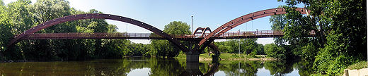
The river flows east into Midland County
where it joins the Tittabawassee River
in downtown Midland
under The Tridge
. The river flows through Mt. Pleasant
and is the focal point of five parks in the city: Riverside Park, Millpond Park, Nelson Park, Chipp-A-Water, and Island Park. In Island Park, the river flows completely around the park and creates a natural island in the center of the city. Three additional Isabella County parks utilize the river for recreation: Meridian Park, Deerfield Nature Park, and Majeski Landing.
The river flows with a mean discharge rate of 254 ft³/s (7.19 m³/s) at its gauge near Mount Pleasant. It is locally known for bass
fishing. Chubs and redhorses
are also abundant. There are two canoe liveries on the river: Chippewa River Outfitters and Buckley's Mountainside Canoe Livery. The liveries offer canoe, kayak, and tubing trips for a few hours to all day, even an overnight camping trip. The river flows through a gravel pit named Hubsher Gravel Pit. The river is a main water source for the city of Mount Pleasant.
Michigan
Michigan is a U.S. state located in the Great Lakes Region of the United States of America. The name Michigan is the French form of the Ojibwa word mishigamaa, meaning "large water" or "large lake"....
that runs 91.8 miles (147.7 km) through the central Lower Peninsula
Lower Peninsula of Michigan
The Lower Peninsula of Michigan is the southern of the two major landmasses of the U.S. state of Michigan. It is surrounded by water on all sides except its southern border, which it shares with Ohio and Indiana. Geographically, the Lower Peninsula has a recognizable shape that many people...
. The Chippewa is a tributary of the Tittabawassee River
Tittabawassee River
The Tittabawassee River is a stream which flows in a generally southeasterly direction through the Lower Peninsula of the U.S. state of Michigan. The river begins at Secord Lake in Clement Township, at the confluence of the East Branch and the Middle Branch...
and is thus part of the Saginaw River
Saginaw River
The Saginaw River is a river in the U.S. state of Michigan. It is formed by the confluence of the Tittabawassee and Shiawassee rivers southwest of Saginaw. It flows northward into the Saginaw Bay of Lake Huron just northeast of Bay City. The watershed area is .The river is an important shipping...
drainage basin. The river is named after the Chippewa people (the Saginaw Chippewa Tribal Nation is located in Isabella County).
The main stem of the river begins in northeast Mecosta County
Mecosta County, Michigan
Mecosta County is a county in the U.S. state of Michigan. The county is named after Chief Mecosta, the leader of the Potawatomi Native American tribe that once traveled the local waterways in search of fish and game. Chief Mecosta was one of the signers the Treaty of Washington in 1836. The easily...
in the village of Barryton
Barryton, Michigan
Barryton is a village in Mecosta County in the U.S. state of Michigan. The population was 381 at the 2000 census. The village is located in Fork Township on M-66...
at 43°44′49"N 85°08′26"W where the north and west branches are impounded. The North Branch Chippewa River, also known as Chippewa Creek (there is a second North Branch Chippewa River further east), rises at 43°52′55"N 85°02′37"W as the outflow of Big Cranberry Lake in Garfield Township
Garfield Township, Clare County, Michigan
Garfield Township is a civil township of Clare County in the U.S. state of Michigan. The population was 1,968 at the 2000 census.-Communities:...
in southwest Clare County
Clare County, Michigan
- Demographics :As of the census of 2000, there were 31,252 people, 12,686 households, and 8,753 families residing in the county. The population density was 55 people per square mile . There were 22,229 housing units at an average density of 39 per square mile...
. The West Branch Chippewa River rises as the outflow of Tubbs Lake, part of a complex of lakes formed by Winchester Dam several miles southwest of Barryton.
The Winchester Dam, built in 1954, impounds 1420 acres (574.7 ha) and forms the Martiny Lake Flooding. The dam, which is owned by the State of Michigan, is identified as a "significant hazard due to its proximity to the Village of Barryton." An 1879 atlas of Mecosta County gives an indication of the area's geography before the dam was built. Several of the lakes that now form lobes in a continuous body of water are clearly seen as separate lakes, some with different names or spellings. Tubbs Lake is called "Tebbs Lake" and Diamond Lake is "Dimon Lake".
The "second" North Branch Chippewa River rises as the outflow of Grass Lake near the boundary between Isabella and Clare counties at 43°48′37"N 84°55′33"W and flows south through into the Chippewa River at 43°35′11"N 84°49′50"W a few miles west of Mount Pleasant
Mount Pleasant, Michigan
Mount Pleasant is a city in the U.S. state of Michigan and the county seat of Isabella County. As of the 2000 census, the city population was 25,946. The 2008 census estimate places the population at 26,675....
.
The river flows east into Midland County
Midland County, Michigan
-Demographics:As of the census of 2000, there were 82,874 people, 31,769 households, and 22,683 families residing in the county. The population density was 159 people per square mile . There were 33,796 housing units at an average density of 65 per square mile...
where it joins the Tittabawassee River
Tittabawassee River
The Tittabawassee River is a stream which flows in a generally southeasterly direction through the Lower Peninsula of the U.S. state of Michigan. The river begins at Secord Lake in Clement Township, at the confluence of the East Branch and the Middle Branch...
in downtown Midland
Midland, Michigan
Midland is a city in the U.S. state of Michigan in the Tri-Cities region of the state. It is the county seat of Midland County. The city's population was 41,863 as of the 2010 census. It is the principal city of the Midland Micropolitan Statistical Area....
under The Tridge
The Tridge
The Tridge is the formal name of a three-way footbridge above the confluence of the Chippewa and Tittabawassee Rivers near downtown Midland, Michigan, in the Tri-Cities. The bridge was constructed in 1981 at a cost of $732,000 and took 6,400 hours of labor....
. The river flows through Mt. Pleasant
Mount Pleasant, Michigan
Mount Pleasant is a city in the U.S. state of Michigan and the county seat of Isabella County. As of the 2000 census, the city population was 25,946. The 2008 census estimate places the population at 26,675....
and is the focal point of five parks in the city: Riverside Park, Millpond Park, Nelson Park, Chipp-A-Water, and Island Park. In Island Park, the river flows completely around the park and creates a natural island in the center of the city. Three additional Isabella County parks utilize the river for recreation: Meridian Park, Deerfield Nature Park, and Majeski Landing.
The river flows with a mean discharge rate of 254 ft³/s (7.19 m³/s) at its gauge near Mount Pleasant. It is locally known for bass
Black bass
Micropterus , is a genus of freshwater fish in the sunfish family of order Perciformes. The type species is M. dolomieu, the smallmouth bass...
fishing. Chubs and redhorses
Moxostoma
Moxostoma is a genus of ray-finned fish in the Catostomidae family.- Species :* Moxostoma albidum * Moxostoma anisurum * Moxostoma ariommum C. R...
are also abundant. There are two canoe liveries on the river: Chippewa River Outfitters and Buckley's Mountainside Canoe Livery. The liveries offer canoe, kayak, and tubing trips for a few hours to all day, even an overnight camping trip. The river flows through a gravel pit named Hubsher Gravel Pit. The river is a main water source for the city of Mount Pleasant.
Tributaries and features
From the mouth:- (left) Pine RiverPine River (Chippewa River)The Pine River is a river in the Lower Peninsula of the U.S. state of Michigan. The Pine River is a tributary of the Chippewa River and is thus part of the Saginaw River drainage basin....
- See Pine RiverPine River (Chippewa River)The Pine River is a river in the Lower Peninsula of the U.S. state of Michigan. The Pine River is a tributary of the Chippewa River and is thus part of the Saginaw River drainage basin....
for tributaries of the Pine River
- See Pine River
- (right) Dice Drain
- (left) Wilson Drain
- (right) Huber Drain
- (left) Baker Drain
- (left) Hoxie Drain
- (left) Little Salt Creek, also known as Little Salt River
- (left) Turkey Creek
- (right) Frost Drain
- (left) Salt Creek, also known as Little Salt Creek, Little Salt River, Salt River
- (left) Kirch Drain
- (right) Thrasher Creek
- (right) Black Creek
- (right) Potter Creek
- (right) Onion Creek
- (right) Childs Creek
- (left) LaStrange Lake
- Lyons Lake
- (left) Mud Lake
- (left) Figg Drain
- (left) Parcher Drain
- (right) Wyant Drain
- (right) Mission Creek
- (right) North Branch Chippewa River
- (left) Hogg Creek
- (left) Hagerman Drain
- (left) Schofield Creek
- (right) Stevenson Lake
- Owens Lake
- Deadman Swamp
- Grass Lake
- (left)Johnson Creek
- Peas Lake
- Wing Lake
- Peas Lake
- (left) Cedar Creek
- (left) Stony Brook
- Woodruff Lake
- (right) Coldwater RiverColdwater River (Isabella County)Coldwater River is a stream in the U.S. state of Michigan. Located in Isabella County, the river rises as the outflow of Littlefield Lake in western Gilmore Township...
- See Coldwater RiverColdwater River (Isabella County)Coldwater River is a stream in the U.S. state of Michigan. Located in Isabella County, the river rises as the outflow of Littlefield Lake in western Gilmore Township...
for tributaries of the Coldwater River
- See Coldwater River
- Lake Isabella
- (left) Squaw Creek
- Long Pond
- (left) Indian Creek
- Indian Lake
- (left) Six Lakes
- Long Lake
- Round Lake
- Hoffman Lake
- Strong Lake
- Bamber Creek
- Hannah Lake
- Moiles Lake
- Bamber Creek
- Markel Lake
- Randall Lake
- (left) Tanner Creek
- (right) Sherman Creek
- (left) West Branch Chippewa River
- (right) Brown Creek
- (right) Helmer Creek
- Winchester Dam forming the Martiny Lake Flooding
- Tubbs Lake
- Lost Lake
- Diamond Lake
- Big Evans Lake
- Roundy Branch
- Hills Lake
- Pine Lake
- Roundy Branch
- Upper Evans Lake
- Manake Lake
- Lower Evans Lake
- Chippewa Creek
- Chippewa Lake
- Long Lake
- Chippewa Lake
- Chippewa Creek
- Saddlebag Lake
- Bullhead Lake
- Boom Lake
- Bass Lake
- Dogfish Lake
- Halfmoon Lake
- Mud Lake
- (right) North Branch Chippewa River
- (left) Rattail Creek
- Rattail Lakes
- (right) Butts Creek
- (right) Benjamin Creek
- (left) Merrill Lake
- (right) Tubs Lake
- (right) Atkinson Creek
- Big Cranberry Lake
- Mystic Lake
- Crooked Lake
- Three Lake Creek
- Three Lake
- Mystic Lake
- (left) Rattail Creek
- (left) Squaw Creek
Drainage basin
(Including the Pine River)- Clare CountyClare County, Michigan- Demographics :As of the census of 2000, there were 31,252 people, 12,686 households, and 8,753 families residing in the county. The population density was 55 people per square mile . There were 22,229 housing units at an average density of 39 per square mile...
- Garfield TownshipGarfield Township, Clare County, MichiganGarfield Township is a civil township of Clare County in the U.S. state of Michigan. The population was 1,968 at the 2000 census.-Communities:...
- Surrey TownshipSurrey Township, MichiganSurrey Township is a civil township of Clare County in the U.S. state of Michigan. The population was 3,555 at the 2000 census. Lake 13 is located in the township.-Geography:...
- Garfield Township
- Gratiot CountyGratiot County, Michigan-US Highways:* US-127 routes north to I-75 and south to Lansing.* BUS US-127 is a loop route through downtown Alma.* BUS US-127 is a loop route through downtown Ithaca.* BUS US-127 is a loop route through downtown St. Louis....
- City of AlmaAlma, MichiganAlma is the largest city in Gratiot County in the U.S. state of Michigan. The population was 9,275 at the 2000 census. It was incorporated as the Village of Alma in 1872 and became a city in 1905....
- Arcada TownshipArcada Township, MichiganArcada Township is a civil township of Gratiot County in the U.S. state of Michigan. As of the 2000 census, the township population was 1,708.-Communities:*The city of Alma is on the northern edge of the township, but is administratively autonomous....
- Bethany TownshipBethany Township, MichiganBethany Township is a civil township of Gratiot County in the U.S. state of Michigan. As of the 2000 census, the township population was 3,492.-Communities:*The city of St...
- Emerson TownshipEmerson Township, MichiganEmerson Township is a civil township of Gratiot County in the U.S. state of Michigan. The population was 966 at the 2000 census.-Communities:*The city of Ithaca is at the southeast corner of the township, but is administratively autonomous....
- Pine River TownshipPine River Township, MichiganPine River Township is a civil township of Gratiot County in the U.S. state of Michigan. The population was 2,451 at the 2000 census.-Communities:*The City of Alma is at the south side of the township, but is administratively autonomous.*The City of St...
- City of St. LouisSt. Louis, MichiganSt. Louis is a city in Gratiot County in the U.S. state of Michigan. As of the 2000 census, the city population was 4,494. The 2010 census estimate places the population at 7,482.-Geography:...
- Seville TownshipSeville Township, MichiganSeville Township is a civil township of Gratiot County in the U.S. state of Michigan. The population was 2,375 at the 2000 census.-Communities:*Elwell is an unincorporated community in the township at . The FIPS place code is 25800....
- Sumner TownshipSumner Township, MichiganSumner Township is a civil township of Gratiot County in the U.S. state of Michigan. The population was 1,911 at the 2000 census.-Communities:...
- New Haven TownshipNew Haven Township, Gratiot County, MichiganNew Haven Township is a civil township of Gratiot County in the U.S. state of Michigan. The population was 1,016 at the 2000 census.-Communities:...
- Newark TownshipNewark Township, MichiganNewark Township is a civil township of Gratiot County in the U.S. state of Michigan. The population was 1,149 at the 2000 census.-Communities:*The city of Ithaca is at the northeast corner of the township, but is administratively autonomous....
- Wheeler TownshipWheeler Township, MichiganWheeler Township is a civil township of Gratiot County in the U.S. state of Michigan. As of the 2000 census, the township population was 2,785. Inside the township is the Village of Breckenridge.-Communities:...
- City of Alma
- Isabella CountyIsabella County, Michigan-Demographics:As of the census of 2000, there were 63,351 people, 22,425 households, and 13,006 families residing in the county. The population density was 110 people per square mile . There were 24,528 housing units at an average density of 43 per square mile...
- Broomfield TownshipBroomfield Township, MichiganBroomfield Township is a civil township of Isabella County in the U.S. state of Michigan. As of the 2000 census, the township population was 1,620.- Communities :...
- Chippewa TownshipChippewa Township, Isabella County, MichiganChippewa Township is a civil township of Isabella County in the U.S. state of Michigan. As of the 2000 census, the township population was 4,617.- Communities :There are no incorporated municipalities within the township....
- Coe TownshipCoe Township, MichiganCoe Township is a civil township of Isabella County in the U.S. state of Michigan. The population was 2,993 at the 2000 census.- Communities :...
- Coldwater TownshipColdwater Township, Isabella County, MichiganColdwater Township is a civil township of Isabella County in the U.S. state of Michigan. The population was 737 at the 2000 census.- Communities :...
- Deerfield TownshipDeerfield Township, Isabella County, MichiganDeerfield Township is a civil township of Isabella County in the U.S. state of Michigan. The population was 3,081 at the 2000 census.-Geography:...
- Fremont TownshipFremont Township, Isabella County, MichiganFremont Township is a civil township of Isabella County in the U.S. state of Michigan. The population was 1,358 at the 2000 census.-Communities:...
- Gilmore TownshipGilmore Township, Isabella County, MichiganGilmore Township is a civil township of Isabella County in the U.S. state of Michigan. The population was 1,376 at the 2000 census.-Geography:...
- Isabella TownshipIsabella Township, MichiganIsabella Township is a civil township of Isabella County in the U.S. state of Michigan. The population was 2,145 at the 2000 census.- Communities :...
- Lincoln TownshipLincoln Township, Isabella County, MichiganLincoln Township is a civil township of Isabella County in the U.S. state of Michigan. The population was 1,936 at the 2000 census.-Geography:...
- City of Mount PleasantMount Pleasant, MichiganMount Pleasant is a city in the U.S. state of Michigan and the county seat of Isabella County. As of the 2000 census, the city population was 25,946. The 2008 census estimate places the population at 26,675....
- Nottawa TownshipNottawa Township, Isabella County, MichiganNottawa Township is a civil township of Isabella County in the U.S. state of Michigan. The population was 2,278 at the 2000 census. The township is named for a local Chippewa chief who lived from 1781 to 1881.- Communities :...
- Rolland TownshipRolland Township, MichiganRolland Township is a civil township of Isabella County in the U.S. state of Michigan. The population was 1,210 at the 2000 census.-Communities:...
- Village of ShepherdShepherd, MichiganShepherd is a village in Isabella County in the U.S. state of Michigan. The population was 1,536 at the 2000 census. The village is within Coe Township.-Geography:According to the United States Census Bureau, the village has a total area of , all land....
- Sherman TownshipSherman Township, Isabella County, MichiganSherman Township is a civil township of Isabella County in the U.S. state of Michigan. The population was 2,616 at the 2000 census.-Communities:There are no incorporated communities within the township. Mt...
- Union Township
- Vernon TownshipVernon Township, Isabella County, MichiganVernon Township is a civil township of Isabella County in the U.S. state of Michigan. The population was 1,342 at the 2000 census.- Communities :...
- Broomfield Township
- Mecosta CountyMecosta County, MichiganMecosta County is a county in the U.S. state of Michigan. The county is named after Chief Mecosta, the leader of the Potawatomi Native American tribe that once traveled the local waterways in search of fish and game. Chief Mecosta was one of the signers the Treaty of Washington in 1836. The easily...
- Chippewa TownshipChippewa Township, Mecosta County, MichiganChippewa Township is a civil township of Mecosta County in the U.S. state of Michigan. As of the 2000 census, the township population was 1,239.-Communities:*Chippewa Lake is a small community within the township on Chippewa Lake and Lake Street...
- Fork TownshipFork Township, MichiganFork Township is a civil township of Mecosta County in the U.S. state of Michigan. The population was 1,678 at the 2000 census.-Geography:According to the United States Census Bureau, the township has a total area of , of which, of it is land and of it is water.-Demographics:As of the census of...
- Martiny TownshipMartiny Township, MichiganMartiny Township is a civil township of Mecosta County in the U.S. state of Michigan. The population was 1,606 at the 2000 census.-Geography:...
- Millbrook TownshipMillbrook Township, MichiganMillbrook Township is a civil township of Mecosta County in the U.S. state of Michigan. The population was 1,081 at the 2000 census.-Geography:...
- Sheridan TownshipSheridan Township, Mecosta County, MichiganSheridan Township is a civil township of Mecosta County in the U.S. state of Michigan. The population was 1,357 at the 2000 census.-Geography:...
- Wheatland TownshipWheatland Township, Mecosta County, MichiganWheatland Township is a civil township of Mecosta County in the U.S. state of Michigan. The population was 1,474 at the 2000 census.- Communities :...
- Chippewa Township
- Midland CountyMidland County, Michigan-Demographics:As of the census of 2000, there were 82,874 people, 31,769 households, and 22,683 families residing in the county. The population density was 159 people per square mile . There were 33,796 housing units at an average density of 65 per square mile...
- Greendale TownshipGreendale Township, MichiganGreendale Township is a civil township of Midland County in the U.S. state of Michigan. As of the 2000 census, the township population was 1,788.-Communities:...
- Homer TownshipHomer Township, Midland County, MichiganHomer Township is a civil township of Midland County in the U.S. state of Michigan. As of the 2000 census, the township population was 3,924.-Geography:...
- Jasper TownshipJasper Township, MichiganJasper Township is a civil township of Midland County in the U.S. state of Michigan. The population was 1,145 at the 2000 census.- Communities :* Pleasant Valley is an unincorporated community in the township at...
- Lee TownshipLee Township, Midland County, MichiganLee Township is a civil township of Midland County in the U.S. state of Michigan. The population was 4,411 at the 2000 census. Lee Township is third in population of the county, after Jerome and Larkin townships.-Geography:...
- City of MidlandMidland, MichiganMidland is a city in the U.S. state of Michigan in the Tri-Cities region of the state. It is the county seat of Midland County. The city's population was 41,863 as of the 2010 census. It is the principal city of the Midland Micropolitan Statistical Area....
- Midland TownshipMidland Township, MichiganMidland Charter Township is a charter township of Midland County in the U.S. state of Michigan. The population was 2,297 at the 2000 census. The largest portion of the City of Midland is located within the boundaries of the survey township, but is administratively autonomous of the civil township...
- Mount Haley TownshipMount Haley Township, MichiganMount Haley Township is a civil township of Midland County in the U.S. state of Michigan. The population was 1,654 at the 2000 census.-Geography:...
- Porter TownshipPorter Township, Midland County, MichiganPorter Township is a civil township of Midland County in the U.S. state of Michigan. The population was 1,270 at the 2000 census.-Geography:...
- Greendale Township
- Montcalm CountyMontcalm County, Michigan-Michigan State Highways:* M-46* M-57* M-66* M-82* M-91-Demographics:As of the census of 2000, there were 61,266 people, 22,079 households, and 16,183 families residing in the county. The population density was 86 people per square mile . There were 25,900 housing units at an average density...
- Ferris TownshipFerris Township, MichiganFerris Township is a civil township of Montcalm County in the U.S. state of Michigan. The population was 1,379 at the 2000 census.-Geography:...
- Home TownshipHome Township, Montcalm County, MichiganHome Township is a civil township of Montcalm County in the U.S. state of Michigan. As of the 2000 census, the township population was 2,708.-Communities:...
- Richland TownshipRichland Township, Montcalm County, MichiganRichland Township is a civil township of Montcalm County in the U.S. state of Michigan. The population was 2,868 at the 2000 census.- Communities :...
- Ferris Township
- Osceola CountyOsceola County, Michigan-Demographics:As of the census of 2000, there were 23,197 people, 8,861 households, and 6,415 families residing in the county. The population density was 41 people per square mile . There were 12,853 housing units at an average density of 23 per square mile...
- Orient TownshipOrient Township, MichiganOrient Township is a civil township of Osceola County in the U.S. state of Michigan. The population was 803 at the 2000 census.-Communities:There are no incorporated municipalities in the township...
- Orient Township