

Interstate 75 in Michigan
Encyclopedia
Interstate 75 is a part of the Interstate Highway System
and runs from Miami, Florida
to Sault Ste. Marie
in the Upper Peninsula
of Michigan
. I-75 enters the state from Ohio
in the south, just to the north of Toledo
. It runs generally north through Detroit
, Pontiac
and Bay City
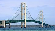
, crossing the Mackinac Bridge
and ending at the Canadian
border in Sault Ste. Marie. On the Canadian side, drivers must use a series of city streets in Sault Ste. Marie, Ontario
to reach Highway 17
, the local route of the Trans-Canada Highway
. The total length in Michigan is 395 miles (635.7 km).
 I-75 connects Michigan's Upper
and Lower
Peninsulas via the 5 miles (8 km) long suspension Mackinac Bridge
.
At the northern end of I-75, at Sault Ste. Marie, Michigan
, the Sault Ste. Marie International Bridge
leads into Canada
, into Sault Ste. Marie, Ontario
. This is the closest connection of any Interstate to the Trans-Canada Highway
.
In Detroit
, the spur route I-375
is the shortest signed spur of I-75 at 1.06 miles (1.71 km). Interstate 375 is the shortest signed Interstate Highway. In addition, at that same junction, the I-75 curve where it shifts from the Fisher Freeway to the Chrysler Freeway
is one of the sharpest on a mainline route in the entire Interstate system, with a 25 mph (40 km/h) advisory speed.
being designated as part of Interstate 75
various sections of it had been constructed.
Between the mid and late 1950s the following sections were constructed:
, a Bascule bridge
across the Saginaw River
was constructed.
In the 1960s, I-75 had several discontiguous segments connected with roads with "TO I-75" signs in addition to US 10 doubling as "TEMP I-75".
The section between Grayling, Michigan
and M-32
was built in 1961. Between Higgins Lake
and Grayling, it was built by converting the northbound lanes of U.S. Route 27
to southbound lanes and building a new set of northbound lanes leaving the former southbound lanes as a strip of grass. The terminus of the freeway near downtown Grayling was converted to a partial interchange for what would become BL I-75. Alongside that, the former segment of US 27 between Grayling and Gaylord, Michigan
was turned back to local control. After this individual segment of freeway was completed, it left a gap between Gaylord and Indian River
which was filled in a year later. While the gap was being filled in, a special "TO I-75" designation was applied to the former segment of US 27. Around that time, US 27's northern terminus was scaled back to 5 miles (8 km) south of Grayling until it was redesignated as an extension of US 127
in 2001.
A 12 miles (19 km) section of I-75 was opened between Gaylord and Waters in July 1962.
In Detroit the Fisher Freeway was built in 'the early 1960s' and then the Chrysler Freeway in 1967.
Until the early 1970s, I-75 between Bay City
and Grayling was routed west to Clare
(along US-10
then north along then-US-27
, and was signed as "TEMP I-75". This freeway segment had some at-grade intersections at the time. In 2002 the portion between Clare and Grayling was redesignated as an extension of US 127
, although it was posted as US 127 on a National Geographic road atlas in the year 2000.
The section between Alger
and Roscommon
was completed in 1973, and the temporary section reverted to U.S. routes, although of freeway quality.
Until the completion of I-75 in 1973, the stretch of freeway between Standish
and West Branch
had the designation of M-76
. When the I-75 signs were erected along the freeway, M-76 vanished from the state road map after 53 years of existence.
In the 1988 the original bascule
Zilwaukee Bridge
across the Saginaw River
was replaced by a much higher structure slightly north of the former bridge.
Until 1987, US 10 and I-75 were the same road between Bay City and Clarkston
. Both also overlapped US 23 between Bay City and Flint. Now, Bay City serves as the eastern terminus of US 10.
As late as 1990, US 31 and US 23 both had their northern termini on I-75's southern approach to the Mackinac Bridge. Even though US 27 was scaled back 94 miles (from Mackinaw City to south of Grayling) in 1961, a lone sign assembly showed all three US highways ending at the same place as late as 1971.
to I-275
and local detours were posted. The freeway re-opened to through traffic in July 2009, hence about all of the signs on I-75 within Detroit's city limits are in the Clearview
typeface.
Interstate Highway System
The Dwight D. Eisenhower National System of Interstate and Defense Highways, , is a network of limited-access roads including freeways, highways, and expressways forming part of the National Highway System of the United States of America...
and runs from Miami, Florida
Miami, Florida
Miami is a city located on the Atlantic coast in southeastern Florida and the county seat of Miami-Dade County, the most populous county in Florida and the eighth-most populous county in the United States with a population of 2,500,625...
to Sault Ste. Marie
Sault Ste. Marie, Michigan
Sault Ste. Marie is a city in and the county seat of Chippewa County in the U.S. state of Michigan. It is in the north-eastern end of Michigan's Upper Peninsula, on the Canadian border, separated from its twin city of Sault Ste. Marie, Ontario, by the St. Marys River...
in the Upper Peninsula
Upper Peninsula of Michigan
The Upper Peninsula of Michigan is the northern of the two major land masses that make up the U.S. state of Michigan. It is commonly referred to as the Upper Peninsula, the U.P., or Upper Michigan. It is also known as the land "above the Bridge" linking the two peninsulas. The peninsula is bounded...
of Michigan
Michigan
Michigan is a U.S. state located in the Great Lakes Region of the United States of America. The name Michigan is the French form of the Ojibwa word mishigamaa, meaning "large water" or "large lake"....
. I-75 enters the state from Ohio
Ohio
Ohio is a Midwestern state in the United States. The 34th largest state by area in the U.S.,it is the 7th‑most populous with over 11.5 million residents, containing several major American cities and seven metropolitan areas with populations of 500,000 or more.The state's capital is Columbus...
in the south, just to the north of Toledo
Toledo, Ohio
Toledo is the fourth most populous city in the U.S. state of Ohio and is the county seat of Lucas County. Toledo is in northwest Ohio, on the western end of Lake Erie, and borders the State of Michigan...
. It runs generally north through Detroit
Detroit, Michigan
Detroit is the major city among the primary cultural, financial, and transportation centers in the Metro Detroit area, a region of 5.2 million people. As the seat of Wayne County, the city of Detroit is the largest city in the U.S. state of Michigan and serves as a major port on the Detroit River...
, Pontiac
Pontiac, Michigan
Pontiac is a city in the U.S. state of Michigan named after the Ottawa Chief Pontiac, located within the Detroit metropolitan area. As of the 2010 census, the city had a total population of 59,515. It is the county seat of Oakland County...
and Bay City
Bay City, Michigan
Bay City is a city in the U.S. state of Michigan located near the base of the Saginaw Bay on Lake Huron. As of the 2010 census, the city's population was 34,932, and is the principal city of the Bay City Metropolitan Statistical Area, which is included in the Saginaw-Bay City-Saginaw Township North...
, crossing the Mackinac Bridge
Mackinac Bridge
The Mackinac Bridge is a suspension bridge spanning the Straits of Mackinac to connect the non-contiguous Upper and Lower peninsulas of the U.S. state of Michigan. Opened in 1957, the bridge is the third longest in total suspension in the world and the longest suspension bridge between anchorages...
and ending at the Canadian
Canada
Canada is a North American country consisting of ten provinces and three territories. Located in the northern part of the continent, it extends from the Atlantic Ocean in the east to the Pacific Ocean in the west, and northward into the Arctic Ocean...
border in Sault Ste. Marie. On the Canadian side, drivers must use a series of city streets in Sault Ste. Marie, Ontario
Sault Ste. Marie, Ontario
Sault Ste. Marie is a city on the St. Marys River in Algoma District, Ontario, Canada. It is the third largest city in Northern Ontario, after Sudbury and Thunder Bay, with a population of 74,948. The community was founded as a French religious mission: Sault either means "jump" or "rapids" in...
to reach Highway 17
Highway 17 (Ontario)
King's Highway 17, more commonly known as Highway 17, is a provincially maintained highway and the primary route of the Trans-Canada Highway through the Canadian province of Ontario. It begins at the Manitoba border west of Kenora and ends south of Arnprior at the western terminus of Highway 417, ...
, the local route of the Trans-Canada Highway
Trans-Canada Highway
The Trans-Canada Highway is a federal-provincial highway system that joins the ten provinces of Canada. It is, along with the Trans-Siberian Highway and Australia's Highway 1, one of the world's longest national highways, with the main route spanning 8,030 km...
. The total length in Michigan is 395 miles (635.7 km).
Route description
Upper Peninsula of Michigan
The Upper Peninsula of Michigan is the northern of the two major land masses that make up the U.S. state of Michigan. It is commonly referred to as the Upper Peninsula, the U.P., or Upper Michigan. It is also known as the land "above the Bridge" linking the two peninsulas. The peninsula is bounded...
and Lower
Lower Peninsula of Michigan
The Lower Peninsula of Michigan is the southern of the two major landmasses of the U.S. state of Michigan. It is surrounded by water on all sides except its southern border, which it shares with Ohio and Indiana. Geographically, the Lower Peninsula has a recognizable shape that many people...
Peninsulas via the 5 miles (8 km) long suspension Mackinac Bridge
Mackinac Bridge
The Mackinac Bridge is a suspension bridge spanning the Straits of Mackinac to connect the non-contiguous Upper and Lower peninsulas of the U.S. state of Michigan. Opened in 1957, the bridge is the third longest in total suspension in the world and the longest suspension bridge between anchorages...
.
At the northern end of I-75, at Sault Ste. Marie, Michigan
Sault Ste. Marie, Michigan
Sault Ste. Marie is a city in and the county seat of Chippewa County in the U.S. state of Michigan. It is in the north-eastern end of Michigan's Upper Peninsula, on the Canadian border, separated from its twin city of Sault Ste. Marie, Ontario, by the St. Marys River...
, the Sault Ste. Marie International Bridge
Sault Ste. Marie International Bridge
The Sault Ste. Marie International Bridge, often known just as the International Bridge, spans the St. Marys River between the United States and Canada connecting the twin cities of Sault Ste. Marie, Michigan and Sault Ste. Marie, Ontario. It serves as the northern terminus of Interstate 75...
leads into Canada
Canada
Canada is a North American country consisting of ten provinces and three territories. Located in the northern part of the continent, it extends from the Atlantic Ocean in the east to the Pacific Ocean in the west, and northward into the Arctic Ocean...
, into Sault Ste. Marie, Ontario
Sault Ste. Marie, Ontario
Sault Ste. Marie is a city on the St. Marys River in Algoma District, Ontario, Canada. It is the third largest city in Northern Ontario, after Sudbury and Thunder Bay, with a population of 74,948. The community was founded as a French religious mission: Sault either means "jump" or "rapids" in...
. This is the closest connection of any Interstate to the Trans-Canada Highway
Trans-Canada Highway
The Trans-Canada Highway is a federal-provincial highway system that joins the ten provinces of Canada. It is, along with the Trans-Siberian Highway and Australia's Highway 1, one of the world's longest national highways, with the main route spanning 8,030 km...
.
In Detroit
Detroit, Michigan
Detroit is the major city among the primary cultural, financial, and transportation centers in the Metro Detroit area, a region of 5.2 million people. As the seat of Wayne County, the city of Detroit is the largest city in the U.S. state of Michigan and serves as a major port on the Detroit River...
, the spur route I-375
Interstate 375 (Michigan)
The unsigned Business Spur Interstate 375 , which is long, continues west on Jefferson Avenue from the southern end of I-375, ending at the entrance to the Detroit–Windsor Tunnel at Randolph Street . Jefferson Avenue past that intersection is M-10, quickly becoming the Lodge Freeway. BS I-375 runs...
is the shortest signed spur of I-75 at 1.06 miles (1.71 km). Interstate 375 is the shortest signed Interstate Highway. In addition, at that same junction, the I-75 curve where it shifts from the Fisher Freeway to the Chrysler Freeway
Chrysler Freeway
The Chrysler Freeway is the name given to a freeway in the Detroit area. It is composed of:*Interstate 375 south of the junction with the Fisher Freeway*Interstate 75 in Michigan north of the junction with the Fisher Freeway...
is one of the sharpest on a mainline route in the entire Interstate system, with a 25 mph (40 km/h) advisory speed.
Names
- The section in Cheboygan CountyCheboygan County, Michigan-Commercial Airline:There are no commercial airline airports in Cheboygan County but the nearest ones are Alpena County Regional Airport, Chippewa County International Airport , and Cherry Capital Airport...
from the southern end of the Mackinac BridgeMackinac BridgeThe Mackinac Bridge is a suspension bridge spanning the Straits of Mackinac to connect the non-contiguous Upper and Lower peninsulas of the U.S. state of Michigan. Opened in 1957, the bridge is the third longest in total suspension in the world and the longest suspension bridge between anchorages...
to the south is known as the G. Mennen Williams Freeway. - The section from the northern end of the Mackinac BridgeMackinac BridgeThe Mackinac Bridge is a suspension bridge spanning the Straits of Mackinac to connect the non-contiguous Upper and Lower peninsulas of the U.S. state of Michigan. Opened in 1957, the bridge is the third longest in total suspension in the world and the longest suspension bridge between anchorages...
in Mackinac CountyMackinac County, Michigan-Local Airports:*Mackinac County Airport *Mackinac Island Airport -Airline service:The nearest airports with scheduled passenger service are:*Chippewa County International Airport in Sault Ste...
proceeding north is known as the Prentiss M. Brown Freeway. - The section between downtown Detroit and Pontiac is known as the (Walter P.) Chrysler Freeway. It is one of busiest segments of I-75 and hosts one of the perennially busiest segments of freeways in Michigan. The Chrysler Freeway continues south as I-375.
- The section through Southern and central Detroit to the Chrysler Freeway is known as the Fisher Freeway
- The section south of the Fisher Freeway is called the Detroit–Toledo Freeway south to the Ohio state line.
Pre designation
Prior to any segment of freeway in MichiganMichigan
Michigan is a U.S. state located in the Great Lakes Region of the United States of America. The name Michigan is the French form of the Ojibwa word mishigamaa, meaning "large water" or "large lake"....
being designated as part of Interstate 75
Interstate 75
Interstate 75 is a major north–south Interstate Highway in the Great Lakes and Southeastern regions of the United States. It travels from State Road 826 and State Road 924 in Hialeah, Florida to Sault Ste. Marie, Michigan, at the Ontario, Canada, border...
various sections of it had been constructed.
Between the mid and late 1950s the following sections were constructed:
- US 2U.S. Route 2U.S. Route 2 is an east–west U.S. Highway spanning across the northern continental United States. US 2 consists of two segments connected by various roadways in southern Canada...
between what is now known as BL I-75 in St. IgnaceSt. Ignace, MichiganSaint Ignace, usually written as St. Ignace, is a city in the U.S. state of Michigan. As of the 2000 census, the city population was 2,678. It is the county seat of Mackinac County. From the Lower Peninsula, St. Ignace is the gateway to the Upper Peninsula.St...
and M-123M-123 (Michigan highway)M-123 is a state trunkline highway in the eastern Upper Peninsula of the U.S. state of Michigan. It is one of only a few highways in Michigan that curve around and form a U-shape. In fact, M-123 has three intersections with only two state trunklines. It meets M-28 twice as a result of its U-shaped...
was the Upper PeninsulaUpper Peninsula of MichiganThe Upper Peninsula of Michigan is the northern of the two major land masses that make up the U.S. state of Michigan. It is commonly referred to as the Upper Peninsula, the U.P., or Upper Michigan. It is also known as the land "above the Bridge" linking the two peninsulas. The peninsula is bounded...
's first segment. - Alt US 24U.S. Route 24U.S. Route 24 is one of the original United States highways of 1926. It originally ran from Pontiac, Michigan, in the east to Kansas City, Missouri, in the west. Today, the highway's eastern terminus is west of Clarkston, Michigan, at an intersection with I-75 and its western terminus is near...
between OhioOhioOhio is a Midwestern state in the United States. The 34th largest state by area in the U.S.,it is the 7th‑most populous with over 11.5 million residents, containing several major American cities and seven metropolitan areas with populations of 500,000 or more.The state's capital is Columbus...
border and US 25U.S. Route 25U.S. Route 25 is a north–south United States highway that runs for from Brunswick, Georgia to the Ohio state line in Covington, Kentucky.-Georgia:...
(now M-125M-125 (Michigan highway)M-125 Connector is a connector route running through Erie. It connects I-75 with M-125. It is a four lane divided highway for its entire length, named "Summit Street" in Erie. It is known internally to the Michigan Department of Transportation as "Connector 2"...
) was the first segment of Michigan's I-75 to cross the state border; and the only freeway to cross the border until the early 1960s. - Mackinac BridgeMackinac BridgeThe Mackinac Bridge is a suspension bridge spanning the Straits of Mackinac to connect the non-contiguous Upper and Lower peninsulas of the U.S. state of Michigan. Opened in 1957, the bridge is the third longest in total suspension in the world and the longest suspension bridge between anchorages...
(on what was then US 27U.S. Route 27U.S. Route 27 is a north–south United States highway in the southern and midwestern United States. The southern terminus is at US 1 in Miami, Florida. The northern terminus is at Interstate 69 in Fort Wayne, Indiana...
) was completed in 1957. - M-20M-20 (Michigan highway)M-20 is a state trunkline highway in the US state of Michigan that runs from New Era to Midland. It crosses through rural Lower Peninsula forest land between the two ends. The highway serves the college towns of Big Rapids and Mt...
(now part of US 10U.S. Route 10U.S. Route 10 is an east–west United States highway formed in 1926. Though it never became the cross-country highway suggested by the "0" as the last digit of its route number, U.S...
) - when this segment became US 10; it carried the temporary Interstate 75 designation.
Post designation
In 1960 the Zilwaukee BridgeZilwaukee Bridge
The Zilwaukee Bridge is a high-level, segmental concrete bridge spanning the Saginaw River in Zilwaukee, Michigan, approximately north of Saginaw, Michigan, United States. The current eight-lane structure, completed in 1988, is the second such bridge at this location, replacing a four-lane bascule...
, a Bascule bridge
Bascule bridge
A bascule bridge is a moveable bridge with a counterweight that continuously balances the span, or "leaf," throughout the entire upward swing in providing clearance for boat traffic....
across the Saginaw River
Saginaw River
The Saginaw River is a river in the U.S. state of Michigan. It is formed by the confluence of the Tittabawassee and Shiawassee rivers southwest of Saginaw. It flows northward into the Saginaw Bay of Lake Huron just northeast of Bay City. The watershed area is .The river is an important shipping...
was constructed.
In the 1960s, I-75 had several discontiguous segments connected with roads with "TO I-75" signs in addition to US 10 doubling as "TEMP I-75".
The section between Grayling, Michigan
Grayling, Michigan
Grayling is a city in the U.S. state of Michigan and the county seat of Crawford County. The population was 1,952 at the 2000 census. Grayling takes its name from the Grayling fish that was once prevalent in its lakes and streams....
and M-32
M-32 (Michigan highway)
M-32 is a state trunkline highway in the Lower Peninsula of the U.S. state of Michigan. It is an east–west route running from M-66 in East Jordan to US Highway 23 in Alpena. It runs via Gaylord and Atlanta through forested terrain...
was built in 1961. Between Higgins Lake
Higgins Lake, Michigan
Higgins Lake is a small unincorporated community along the southern and western shores of Higgins Lake, a recreational and fishing lake in Roscommon County, in the U.S. state of Michigan. Higgins Lake is the name of the post office for the area, with ZIP code 48627...
and Grayling, it was built by converting the northbound lanes of U.S. Route 27
U.S. Route 27
U.S. Route 27 is a north–south United States highway in the southern and midwestern United States. The southern terminus is at US 1 in Miami, Florida. The northern terminus is at Interstate 69 in Fort Wayne, Indiana...
to southbound lanes and building a new set of northbound lanes leaving the former southbound lanes as a strip of grass. The terminus of the freeway near downtown Grayling was converted to a partial interchange for what would become BL I-75. Alongside that, the former segment of US 27 between Grayling and Gaylord, Michigan
Gaylord, Michigan
Gaylord is a city in the U.S. state of Michigan. As of the 2000 census, the city population was 3,681. It is the county seat of Otsego County. The city is also the seat of the Roman Catholic Diocese of Gaylord; it is by far the smallest settlement serving as the location of an active Roman...
was turned back to local control. After this individual segment of freeway was completed, it left a gap between Gaylord and Indian River
Indian River, Michigan
Indian River is an unincorporated community in Cheboygan County in the U.S. state of Michigan. It is a census-designated place for statistical purposes and is not legally recognized as a municipality. The population was 2,008 at the 2000 census....
which was filled in a year later. While the gap was being filled in, a special "TO I-75" designation was applied to the former segment of US 27. Around that time, US 27's northern terminus was scaled back to 5 miles (8 km) south of Grayling until it was redesignated as an extension of US 127
U.S. Route 127
U.S. Route 127 is a long north–south United States highway in the eastern half of the United States. The southern terminus of the route is at U.S. Route 27 in Chattanooga, Tennessee. The northern terminus is at Interstate 75 near Grayling, Michigan...
in 2001.
A 12 miles (19 km) section of I-75 was opened between Gaylord and Waters in July 1962.
In Detroit the Fisher Freeway was built in 'the early 1960s' and then the Chrysler Freeway in 1967.
Until the early 1970s, I-75 between Bay City
Bay City, Michigan
Bay City is a city in the U.S. state of Michigan located near the base of the Saginaw Bay on Lake Huron. As of the 2010 census, the city's population was 34,932, and is the principal city of the Bay City Metropolitan Statistical Area, which is included in the Saginaw-Bay City-Saginaw Township North...
and Grayling was routed west to Clare
Clare, Michigan
Clare is a city in Clare and Isabella counties in the U.S. state of Michigan. Located primarily in Clare County, the city had a population of 3,173 at the 2000 census....
(along US-10
U.S. Route 10
U.S. Route 10 is an east–west United States highway formed in 1926. Though it never became the cross-country highway suggested by the "0" as the last digit of its route number, U.S...
then north along then-US-27
U.S. Route 27
U.S. Route 27 is a north–south United States highway in the southern and midwestern United States. The southern terminus is at US 1 in Miami, Florida. The northern terminus is at Interstate 69 in Fort Wayne, Indiana...
, and was signed as "TEMP I-75". This freeway segment had some at-grade intersections at the time. In 2002 the portion between Clare and Grayling was redesignated as an extension of US 127
U.S. Route 127
U.S. Route 127 is a long north–south United States highway in the eastern half of the United States. The southern terminus of the route is at U.S. Route 27 in Chattanooga, Tennessee. The northern terminus is at Interstate 75 near Grayling, Michigan...
, although it was posted as US 127 on a National Geographic road atlas in the year 2000.
The section between Alger
Moffatt Township, Michigan
Moffatt Township is a civil township of Arenac County in the U.S. state of Michigan. The population was 1,121 at the 2000 census.-Communities:...
and Roscommon
Roscommon, Michigan
Roscommon is a village in the U.S. state of Michigan. As of the 2000 census, the village population was 1,133. It is the county seat of Roscommon County....
was completed in 1973, and the temporary section reverted to U.S. routes, although of freeway quality.
Until the completion of I-75 in 1973, the stretch of freeway between Standish
Standish, Michigan
Standish is a city in the U.S. state of Michigan. As of the 2000 census, the city population was 1,581. It is the county seat of Arenac County.The town was platted by John D. Standish in 1871...
and West Branch
West Branch, Michigan
West Branch is a city in the U.S. state of Michigan. As of the 2000 census, the city population was 1,926. It is the county seat of Ogemaw County. The city is located within West Branch Township, but is politically independent.-History:...
had the designation of M-76
M-76 (Michigan highway)
M-76 is a former state trunkline highway designation in the Lower Peninsula of the US state of Michigan. The highway's designation was decommissioned when the last section of it was converted to freeway as a part of the present-day Interstate 75 . At that time, M-76 extended from US Highway 23 ...
. When the I-75 signs were erected along the freeway, M-76 vanished from the state road map after 53 years of existence.
In the 1988 the original bascule
Bascule bridge
A bascule bridge is a moveable bridge with a counterweight that continuously balances the span, or "leaf," throughout the entire upward swing in providing clearance for boat traffic....
Zilwaukee Bridge
Zilwaukee Bridge
The Zilwaukee Bridge is a high-level, segmental concrete bridge spanning the Saginaw River in Zilwaukee, Michigan, approximately north of Saginaw, Michigan, United States. The current eight-lane structure, completed in 1988, is the second such bridge at this location, replacing a four-lane bascule...
across the Saginaw River
Saginaw River
The Saginaw River is a river in the U.S. state of Michigan. It is formed by the confluence of the Tittabawassee and Shiawassee rivers southwest of Saginaw. It flows northward into the Saginaw Bay of Lake Huron just northeast of Bay City. The watershed area is .The river is an important shipping...
was replaced by a much higher structure slightly north of the former bridge.
Until 1987, US 10 and I-75 were the same road between Bay City and Clarkston
Clarkston, Michigan
Clarkston, known officially by the name City of the Village of Clarkston, is a small city located within Independence Charter Township in Oakland County in the U.S. state of Michigan. The population was 882 at the 2010 census.-Overview:...
. Both also overlapped US 23 between Bay City and Flint. Now, Bay City serves as the eastern terminus of US 10.
As late as 1990, US 31 and US 23 both had their northern termini on I-75's southern approach to the Mackinac Bridge. Even though US 27 was scaled back 94 miles (from Mackinaw City to south of Grayling) in 1961, a lone sign assembly showed all three US highways ending at the same place as late as 1971.
Late 2000s
Beginning on February 25, 2008, the Interstate closed completely to traffic in both directions from Rosa Parks Boulevard (Exit 49) to Clark Street (Exit 47) in Detroit. This facilitated the complete rebuilding of the road as part of the Gateway Project to better connect Interstates 75 and 96 to the Ambassador Bridge. Through traffic on 75 was instructed to take I-94Interstate 94
Interstate 94 is the northernmost east–west Interstate Highway, connecting the Great Lakes and Intermountain regions of the United States. I-94's western terminus is in Billings, Montana at a junction with Interstate 90; its eastern terminus is the U.S...
to I-275
Interstate 275 (Michigan)
Interstate 275 in the US state of Michigan is an Interstate Highway that functions as a western bypass of the Detroit metropolitan area. The Michigan Department of Transportation maintains it as a component of the larger state trunkline highway system. The freeway runs through the western suburbs...
and local detours were posted. The freeway re-opened to through traffic in July 2009, hence about all of the signs on I-75 within Detroit's city limits are in the Clearview
Clearview (typeface)
Clearview, also known as Clearview Hwy, is the name of a humanist sans-serif typeface family for guide signs on roads in the United States. It was developed by independent researchers with the help of the Texas Transportation Institute and the Pennsylvania Transportation Institute, under the...
typeface.
Spur routes
- I-275Interstate 275 (Michigan)Interstate 275 in the US state of Michigan is an Interstate Highway that functions as a western bypass of the Detroit metropolitan area. The Michigan Department of Transportation maintains it as a component of the larger state trunkline highway system. The freeway runs through the western suburbs...
- Begins as a loop from Northern Monroe County and continues to connect up with Interstate 696. Was going to connect back up with I-75 north of Pontiac. Serves the Western population of Wayne County and Detroit Metro Airport.
- I-375Interstate 375 (Michigan)The unsigned Business Spur Interstate 375 , which is long, continues west on Jefferson Avenue from the southern end of I-375, ending at the entrance to the Detroit–Windsor Tunnel at Randolph Street . Jefferson Avenue past that intersection is M-10, quickly becoming the Lodge Freeway. BS I-375 runs...
- Is the shortest signed Interstate in the nation. It serves the immediate downtown Detroit area.
- I-475Interstate 475 (Michigan)Interstate 475 is an Interstate Highway in the US state of Michigan. I-475 is a bypass route that serves the downtown area of Flint while its parent, I-75, passes through the west side of the city...
- Known as the U.A.W. Freeway. Serves Flint's downtown areas as I-75 goes to the west side of the city.
- I-675Interstate 675 (Michigan)Interstate 675 is an Interstate Highway in the US state of Michigan. I-675 is a loop route through downtown Saginaw as I-75 passes on the east side of the city....
- A loop into the city of Saginaw and back out north of the city. Served as an alternate to I-75 when the drawbridge over the Saginaw River was still operating.