
London E1
Encyclopedia
The E postcode area, also known as the London E postcode area, is the part of the London
post town covering part of east London
, England
and also Sewardstone
in Essex
.
The Eastern District Office is located on Whitechapel Road
and was the eastern terminus for the former London Post Office Railway
, which has been mothballed since 2003. The railway ran 6.5 miles (10.5 km) to the Paddington
Head District Sorting Office.
The E20 postcode has been used fictionally as the postcode on the series Eastenders
. However, E20 became a real postcode in 2011, being created for the new Olympic Park in Stratford, site of the 2012 Summer Olympics
, from within the E15 postcode.
|-
! E1
| LONDON
| Eastern head district: Aldgate
(part), Bishopsgate
(part), Whitechapel
, Shoreditch
(part), Spitalfields
, Shadwell
, Stepney
, Mile End
(part), Portsoken
| Tower Hamlets, Hackney, City of London
|-
! E1W
| LONDON
| Wapping
| Tower Hamlets
|-
! E2
| LONDON
| Bethnal Green district: Bethnal Green
, Haggerston
, Shoreditch
(part), Cambridge Heath
| Tower Hamlets, Hackney
|-
! E3
| LONDON
| Bow district: Bow
, Bromley-by-Bow
, Old Ford, Mile End
, Three Mills
, London Gas Museum
| Tower Hamlets, Newham
|-
! E4
| LONDON
| Chingford district: Chingford
, Sewardstone
, Highams Park
, Upper Edmonton
(part)
| Waltham Forest, Enfield
|-
! E5
| LONDON
| Clapton district: Upper Clapton
, Lower Clapton
, Stoke Newington
(part)
|Hackney
|-
! E6
| LONDON
| East Ham district: East Ham
, Beckton
, Upton Park (part), Barking
(part)
| Newham, Barking and Dagenham
|-
! E7
| LONDON
| Forest Gate district: Forest Gate
, Stratford
(part)
| Newham, Waltham Forest
|-
! E8
| LONDON
| Hackney district: Hackney Central
, Dalston
, London Fields
| Hackney
|-
! E9
| LONDON
| Homerton district: Homerton
, Hackney Wick
, South Hackney
, Hackney Marshes
, Victoria Park
| Hackney, Tower Hamlets
|-
! E10
| LONDON
| Leyton district: Leyton
, Temple Mills
, Hackney Marshes
(part) Upper Clapton
(part), Walthamstow Marshes
| Waltham Forest, Hackney
|-
! E11
| LONDON
| Leytonstone district: Leytonstone
, Wanstead
, Aldersbrook
(part), Snaresbrook
, Cann Hall
| Waltham Forest, Redbridge
|-
! E12
| LONDON
| Manor Park district: Manor Park
, Little Ilford
, Aldersbrook
(part)
| Newham, Redbridge
|-
! E13
| LONDON
| Plaistow district: Plaistow
, West Ham
(part), Upton Park (part)
| Newham
|-
! E14
| LONDON
| Poplar district: Poplar
, Isle of Dogs
, Limehouse
, Canary Wharf
, Blackwall
, Cubitt Town
| Tower Hamlets
|-
! E15
| LONDON
| Stratford district: Stratford
, West Ham
(part), Maryland
, Leyton
(part), Leytonstone
(part) Temple Mills
(part), Hackney Wick
(part), Bow
(part)
| Newham, Waltham Forest, Hackney, Tower Hamlets
|-
! E16
| LONDON
| Victoria Docks district: Silvertown
, North Woolwich
, Canning Town
, Custom House
, London City Airport
| Newham
|-
! E17
| LONDON
| Walthamstow district: Walthamstow
, Upper Walthamstow
| Waltham Forest
|-
! E18
| LONDON
| Woodford district: Woodford, South Woodford
| Redbridge
|-
! E20
| LONDON
| Olympic Park district: Olympic Park
Stratford
, Homerton
, Leyton
, Bow
and, fictionally, Eastenders
| Newham, Waltham Forest, Hackney, Tower Hamlets
|-
! E77
| LONDON
| Non-geographic postcode district (NatWest, located in E1)
| Tower Hamlets
|-
! E98
| LONDON
| Non-geographic postcode district (News International
, located in E1W)
| Tower Hamlets
|}
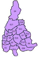
frontage to the south and is central to London. Postcode districts E6, E14 and E16 also have river frontages in the south. The River Roding
and the North Circular Road
form part of the boundary in the east. The postcode area maps roughly to the combined area of the London Borough of Tower Hamlets
, London Borough of Newham
and London Borough of Waltham Forest
. The eastern part of the London Borough of Hackney
, western sections of the London Borough of Redbridge
(E11, E12, E18) and London Borough of Barking and Dagenham
(E6), and a small part of the Epping Forest
district of Essex
(E4) are within the postcode area.
.
London postal district
The London postal district is the area in England, currently of , to which mail addressed to the LONDON post town is delivered. The area was initially devised in 1856 and throughout its history has been subject to periodic reorganisation, contraction and division into increasingly smaller postal...
post town covering part of east London
London
London is the capital city of :England and the :United Kingdom, the largest metropolitan area in the United Kingdom, and the largest urban zone in the European Union by most measures. Located on the River Thames, London has been a major settlement for two millennia, its history going back to its...
, England
England
England is a country that is part of the United Kingdom. It shares land borders with Scotland to the north and Wales to the west; the Irish Sea is to the north west, the Celtic Sea to the south west, with the North Sea to the east and the English Channel to the south separating it from continental...
and also Sewardstone
Sewardstone
Sewardstone is a place in the Epping Forest district of Essex, England.It is located 11.6 miles north north-east of Charing Cross and is the only area outside Greater London to be covered by a London postcode district . The area consists of scattered development with large sections of open land...
in Essex
Essex
Essex is a ceremonial and non-metropolitan county in the East region of England, and one of the home counties. It is located to the northeast of Greater London. It borders with Cambridgeshire and Suffolk to the north, Hertfordshire to the west, Kent to the South and London to the south west...
.
Postal administration
The current E postcode area was originally formed in 1866 as a merger of the E and NE areas created in 1858. In 1917 the postal districts were numbered alphabetically by their location; the districts usually cover a wider area than their names might suggest. As of 2004, the district names do not form part of the postal address. Due to high demand, sector 9 of the E1 postcode district was split and recoded in 1999 to create an E1W postcode district around Wapping; the rest of the district did not gain an additional character. Where districts are used for purposes other than the sorting of mail, such as use as a geographic reference and on street signs, E1 and E1W continue to be classed as one 'district'. The E postcode area contains two non-geographic postcode districts for high-volume business users, E77 and E98.The Eastern District Office is located on Whitechapel Road
Whitechapel Road
Whitechapel Road is a major arterial road in the East End of London, England. It connects Whitechapel High Street to the west with Mile End Road to the east and forms part of the A11 road. It is a main shopping street in the Whitechapel area of Tower Hamlets and has a street market...
and was the eastern terminus for the former London Post Office Railway
London Post Office Railway
The Post Office Railway, also known as Mail Rail, was a narrow-gauge driverless private underground railway in London built by the Post Office with assistance from the Underground Electric Railways Company of London to move mail between sorting offices...
, which has been mothballed since 2003. The railway ran 6.5 miles (10.5 km) to the Paddington
Paddington
Paddington is a district within the City of Westminster, in central London, England. Formerly a metropolitan borough, it was integrated with Westminster and Greater London in 1965...
Head District Sorting Office.
The E20 postcode has been used fictionally as the postcode on the series Eastenders
EastEnders
EastEnders is a British television soap opera, first broadcast in the United Kingdom on BBC One on 19 February 1985 and continuing to today. EastEnders storylines examine the domestic and professional lives of the people who live and work in the fictional London Borough of Walford in the East End...
. However, E20 became a real postcode in 2011, being created for the new Olympic Park in Stratford, site of the 2012 Summer Olympics
2012 Summer Olympics
The 2012 Summer Olympic Games, officially known as the "London 2012 Olympic Games", are scheduled to take place in London, England, United Kingdom from 27 July to 12 August 2012...
, from within the E15 postcode.
List of postcode districts
The approximate coverage of the postcode districts, with the historic postal district names shown in italics:|-
! E1
| LONDON
| Eastern head district: Aldgate
Aldgate
Aldgate was the eastern most gateway through London Wall leading from the City of London to Whitechapel and the east end of London. Aldgate gives its name to a ward of the City...
(part), Bishopsgate
Bishopsgate
Bishopsgate is a road and ward in the northeast part of the City of London, extending north from Gracechurch Street to Norton Folgate. It is named after one of the original seven gates in London Wall...
(part), Whitechapel
Whitechapel
Whitechapel is a built-up inner city district in the London Borough of Tower Hamlets, London, England. It is located east of Charing Cross and roughly bounded by the Bishopsgate thoroughfare on the west, Fashion Street on the north, Brady Street and Cavell Street on the east and The Highway on the...
, Shoreditch
Shoreditch
Shoreditch is an area of London within the London Borough of Hackney in England. It is a built-up part of the inner city immediately to the north of the City of London, located east-northeast of Charing Cross.-Etymology:...
(part), Spitalfields
Spitalfields
Spitalfields is a former parish in the borough of Tower Hamlets, in the East End of London, near to Liverpool Street station and Brick Lane. The area straddles Commercial Street and is home to many markets, including the historic Old Spitalfields Market, founded in the 17th century, Sunday...
, Shadwell
Shadwell
Shadwell is an inner-city district situated within the London Borough of Tower Hamlets located on the north bank of the Thames between Wapping to the south and Ratcliff to the east...
, Stepney
Stepney
Stepney is a district of the London Borough of Tower Hamlets in London's East End that grew out of a medieval village around St Dunstan's church and the 15th century ribbon development of Mile End Road...
, Mile End
Mile End
Mile End is an area within the East End of London, England, and part of the London Borough of Tower Hamlets. It is located east-northeast of Charing Cross...
(part), Portsoken
Portsoken
Portsoken is a historical district in the City of London, located outside the former London Wall, on the eastern part of the City, near Aldgate. It is one of the 25 wards of the City....
| Tower Hamlets, Hackney, City of London
City of London
The City of London is a small area within Greater London, England. It is the historic core of London around which the modern conurbation grew and has held city status since time immemorial. The City’s boundaries have remained almost unchanged since the Middle Ages, and it is now only a tiny part of...
|-
! E1W
| LONDON
| Wapping
Wapping
Wapping is a place in the London Borough of Tower Hamlets which forms part of the Docklands to the east of the City of London. It is situated between the north bank of the River Thames and the ancient thoroughfare simply called The Highway...
| Tower Hamlets
|-
! E2
| LONDON
| Bethnal Green district: Bethnal Green
Bethnal Green
Bethnal Green is a district of the East End of London, England and part of the London Borough of Tower Hamlets, with the far northern parts falling within the London Borough of Hackney. Located northeast of Charing Cross, it was historically an agrarian hamlet in the ancient parish of Stepney,...
, Haggerston
Haggerston
Haggerston is an area and a electoral ward in the London Borough of Hackney, in northeast London, UK. It is bounded by Hackney Road on the south, Kingsland Road on the west, Middleton Road on the north with London Fields and Broadway Market on the east...
, Shoreditch
Shoreditch
Shoreditch is an area of London within the London Borough of Hackney in England. It is a built-up part of the inner city immediately to the north of the City of London, located east-northeast of Charing Cross.-Etymology:...
(part), Cambridge Heath
Cambridge Heath
Cambridge Heath is a place in the London Borough of Tower Hamlets. The earliest recorded use of the name is as Camprichthesheth in 1275.It forms part of the East End of London and is located north of Bethnal Green. The area is the location, at Patriot Square, of the former Bethnal Green Town Hall...
| Tower Hamlets, Hackney
|-
! E3
| LONDON
| Bow district: Bow
Bow, London
Bow is an area of London, England, United Kingdom in the London Borough of Tower Hamlets. It is a built-up, mostly residential district located east of Charing Cross, and is a part of the East End.-Bridges at Bowe:...
, Bromley-by-Bow
Bromley-by-Bow
Bromley-by-Bow, historically and officially Bromley, is a place in the London Borough of Tower Hamlets. It is an inner-city district situated east north-east of Charing Cross.-Toponymy:...
, Old Ford, Mile End
Mile End
Mile End is an area within the East End of London, England, and part of the London Borough of Tower Hamlets. It is located east-northeast of Charing Cross...
, Three Mills
Three Mills
The Three Mills are former working mills on the River Lea in the East End of London, one of London’s oldest extant industrial centres. The largest and most powerful of the four remaining tidal mills is possibly the largest tidal mill in the world...
, London Gas Museum
London Gas Museum
The London Gas Museum was a museum in the London Borough of Newham in east London, England.It was situated on Twelvetrees Crescent, on the eastern side of the River Lea and near to Bromley-by-Bow tube station...
| Tower Hamlets, Newham
|-
! E4
| LONDON
| Chingford district: Chingford
Chingford
Chingford is a district of north east London, bordering on Enfield and Edmonton to the west, Woodford to the east, Walthamstow and Stratford to the south and Essex to the north. It is situated northeast of Charing Cross and forms part of the London Borough of Waltham Forest...
, Sewardstone
Sewardstone
Sewardstone is a place in the Epping Forest district of Essex, England.It is located 11.6 miles north north-east of Charing Cross and is the only area outside Greater London to be covered by a London postcode district . The area consists of scattered development with large sections of open land...
, Highams Park
Highams Park
Highams Park is a district in the London Borough of Waltham Forest, England, adjacent to Epping Forest. The forest at Highams Park contains a boating lake formed by Humphry Repton after damming the River Ching. There are parks and basic shopping facilities such as Budgens, but no major supermarket...
, Upper Edmonton
Upper Edmonton
Upper Edmonton is a part of Edmonton, which is located in the eastern part of the London Borough of Enfield, England. The main shopping area of Upper Edmonton is often referred to as "The Angel" by locals and is...
(part)
| Waltham Forest, Enfield
|-
! E5
| LONDON
| Clapton district: Upper Clapton
Upper Clapton
Upper Clapton is a district in the London Borough of Hackney. It is bounded by the Hackney districts of Stamford Hill to the west, Lower Clapton and Lea Bridge to the south and the Haringey district of South Tottenham to the north...
, Lower Clapton
Lower Clapton
Lower Clapton is a district within the London Borough of Hackney.It is immediately adjacent to central Hackney - bounded, roughly, by the western side of Hackney Downs , the Lea Valley , Clifden Road and the Lea Bridge Road...
, Stoke Newington
Stoke Newington
Stoke Newington is a district in the London Borough of Hackney. It is north-east of Charing Cross.-Boundaries:In modern terms, Stoke Newington can be roughly defined by the N16 postcode area . Its southern boundary with Dalston is quite ill-defined too...
(part)
|Hackney
|-
! E6
| LONDON
| East Ham district: East Ham
East Ham
East Ham is a suburban district of London, England, and part of the London Borough of Newham. It is a built-up district located 8 miles east-northeast of Charing Cross...
, Beckton
Beckton
Beckton is part of the London Borough of Newham, England, located east of Charing Cross.Its boundaries are the A13 trunk road to the north, Barking Creek to the east, the Royal Docks to the south, and Prince Regent Lane to the west. The area around Prince Regent Lane is also known as Custom House...
, Upton Park (part), Barking
Barking
Barking is a suburban town in the London Borough of Barking and Dagenham, in East London, England. A retail and commercial centre situated in the west of the borough, it lies east of Charing Cross. Barking was in the historic county of Essex until it was absorbed by Greater London. The area is...
(part)
| Newham, Barking and Dagenham
|-
! E7
| LONDON
| Forest Gate district: Forest Gate
Forest Gate
Forest Gate is a residential area in the London Borough of Newham, 7 miles northeast of Charing Cross. It is bordered by Manor Park to the east and and to the west lies Stratford town centre. The northern half of the busy Green Street runs through it.-History:...
, Stratford
Stratford, London
Stratford is a place in the London Borough of Newham, England. It is located east northeast of Charing Cross and is one of the major centres identified in the London Plan. It was historically an agrarian settlement in the ancient parish of West Ham, which transformed into an industrial suburb...
(part)
| Newham, Waltham Forest
|-
! E8
| LONDON
| Hackney district: Hackney Central
Hackney Central
Hackney Central is the central district of the London Borough of Hackney in London, England. It comprises the area roughly surrounding, and extending north from Mare Street. It is situated north east of Charing Cross...
, Dalston
Dalston
Dalston is a district of north-east London, England, located in the London Borough of Hackney. It is situated northeast of Charing Cross. The area is identified in the London Plan as one of 35 major centres in Greater London...
, London Fields
London Fields
London Fields is a park and the name of an area of London, situated in the eastern borough of Hackney. The park itself was first recorded in 1540. At this time it was common ground and was used by drovers to pasture their livestock before taking them to market in London.London Fields is just over ...
| Hackney
|-
! E9
| LONDON
| Homerton district: Homerton
Homerton
Homerton is a place in the London Borough of Hackney. It is bordered to the west by Hackney Central, to the north by Lower Clapton, in the east by Hackney Wick, Leyton and by South Hackney to the south.-Origins:...
, Hackney Wick
Hackney Wick
Hackney Wick is an area straddling the boundary between the London Borough of Hackney and the London Borough of Tower Hamlets in east London. It is an inner-city development situated 5 miles northeast of Charing Cross...
, South Hackney
South Hackney
South Hackney is a district in the London Borough of Hackney situated north east of Charing Cross.It is immediately north of Victoria Park and the area centred on Victoria Park Road and Lauriston Road...
, Hackney Marshes
Hackney Marshes
Hackney Marshes is an area of grassland on the western bank of the River Lea in the London Borough of Hackney. It was incorporated into the Lee Valley Park in 1967...
, Victoria Park
Victoria Park, East London
Victoria Park is 86.18 hectares of open space that stretches out across part of the East End of London, England bordering parts of Bethnal Green, Hackney, and Bow, such as along Old Ford Road, London E3 and Victoria Park Road E9. The park is entirely within the London Borough of Tower Hamlets...
| Hackney, Tower Hamlets
|-
! E10
| LONDON
| Leyton district: Leyton
Leyton
Leyton is an area of north-east London and part of the London Borough of Waltham Forest, located north east of Charing Cross. It borders Walthamstow and Leytonstone; Stratford in Newham; and Homerton and Lower Clapton in the London Borough of Hackney....
, Temple Mills
Temple Mills
Temple Mills is a northerly part of Stratford, south of Leyton, located within the London borough of Newham in east LondonToday, Temple Mills is surrounded at present by former railway tracks and works belonging to the Great Eastern Railway...
, Hackney Marshes
Hackney Marshes
Hackney Marshes is an area of grassland on the western bank of the River Lea in the London Borough of Hackney. It was incorporated into the Lee Valley Park in 1967...
(part) Upper Clapton
Upper Clapton
Upper Clapton is a district in the London Borough of Hackney. It is bounded by the Hackney districts of Stamford Hill to the west, Lower Clapton and Lea Bridge to the south and the Haringey district of South Tottenham to the north...
(part), Walthamstow Marshes
Walthamstow Marshes
Walthamstow Marshes, located in the London Borough of Waltham Forest, is a designated Site of Special Scientific Interest SSSI. It was once an area of lammas land — strips of meadow used for growing crops and grazing cattle....
| Waltham Forest, Hackney
|-
! E11
| LONDON
| Leytonstone district: Leytonstone
Leytonstone
Leytonstone is an area of east London and part of the London Borough of Waltham Forest. It is a high density suburban area, located seven miles north east of Charing Cross in the ceremonial county of Greater London and the historic county of Essex...
, Wanstead
Wanstead
Wanstead is a suburban area in the London Borough of Redbridge, North-East London. The main road going through Wanstead is the A12. The name is from the Anglo-Saxon words wænn and stede, meaning "settlement on a small hill"....
, Aldersbrook
Aldersbrook
Aldersbrook is the name given to an Edwardian housing estate in North-East London. It is named after the , a small tributary of the River Roding. It is bound by Aldersbrook Road to the south, Bush Wood to the west, Wanstead Park to the north, and the City of London Cemetery and Crematorium to the...
(part), Snaresbrook
Snaresbrook
Snaresbrook is an area of north-east London, mostly in the London Borough of Redbridge. A small part falls within the London Borough of Waltham Forest...
, Cann Hall
Cann Hall
Cann Hall is a ward, and former civil parish, in the London Borough of Waltham Forest. It is north of Stratford and Forest Gate, east of Leyton, and west of Wanstead Flats, the southernmost tip of Epping Forest.-History:...
| Waltham Forest, Redbridge
|-
! E12
| LONDON
| Manor Park district: Manor Park
Manor Park, London
Manor Park is the name of an area in the London Borough of Newham, as well as of the local railway station and cemetery. There is another railway station - Woodgrange Park...
, Little Ilford
Little Ilford
Little Ilford is a district of London, England in the London Borough of Newham and the name of a ward in that borough.-Locale:It is located near to Ilford in the London Borough of Redbridge...
, Aldersbrook
Aldersbrook
Aldersbrook is the name given to an Edwardian housing estate in North-East London. It is named after the , a small tributary of the River Roding. It is bound by Aldersbrook Road to the south, Bush Wood to the west, Wanstead Park to the north, and the City of London Cemetery and Crematorium to the...
(part)
| Newham, Redbridge
|-
! E13
| LONDON
| Plaistow district: Plaistow
Plaistow, Newham
Plaistow is a place in the London Borough of Newham in east London. It formed part of the County Borough of West Ham in Essex until 1965.Plaistow is a mainly residential area, including several council estates; the main road is the A112 - Plaistow Road, High Street, Broadway, Greengate Street and...
, West Ham
West Ham
West Ham is in the London Borough of Newham in London, England. In the west it is a post-industrial neighbourhood abutting the site of the London Olympic Park and in the east it is mostly residential, consisting of Victorian terraced housing interspersed with higher density post-War social housing...
(part), Upton Park (part)
| Newham
|-
! E14
| LONDON
| Poplar district: Poplar
Poplar, London
Poplar is a historic, mainly residential area of the East End of London in the London Borough of Tower Hamlets. It is about east of Charing Cross. Historically a hamlet in the parish of Stepney, Middlesex, in 1817 Poplar became a civil parish. In 1855 the Poplar District of the Metropolis was...
, Isle of Dogs
Isle of Dogs
The Isle of Dogs is a former island in the East End of London that is bounded on three sides by one of the largest meanders in the River Thames.-Etymology:...
, Limehouse
Limehouse
Limehouse is a place in the London Borough of Tower Hamlets. It is on the northern bank of the River Thames opposite Rotherhithe and between Ratcliff to the west and Millwall to the east....
, Canary Wharf
Canary Wharf
Canary Wharf is a major business district located in London, United Kingdom. It is one of London's two main financial centres, alongside the traditional City of London, and contains many of the UK's tallest buildings, including the second-tallest , One Canada Square...
, Blackwall
Blackwall, London
Blackwall is an area of the East End of London, situated in the London Borough of Tower Hamlets on the north bank of the River Thames.The district around Blackwall Stairs was known as Blackwall by at least the 14th century. This presumably derives from the colour of the river wall, constructed in...
, Cubitt Town
Cubitt Town
Cubitt Town is an area on the Isle of Dogs in Tower Hamlets in London, England. It is on the east of the Isle, facing Greenwich across the River Thames. To the west is Millwall, to the northwest Canary Wharf and to the north, across the Blue Bridge, Blackwall...
| Tower Hamlets
|-
! E15
| LONDON
| Stratford district: Stratford
Stratford, London
Stratford is a place in the London Borough of Newham, England. It is located east northeast of Charing Cross and is one of the major centres identified in the London Plan. It was historically an agrarian settlement in the ancient parish of West Ham, which transformed into an industrial suburb...
, West Ham
West Ham
West Ham is in the London Borough of Newham in London, England. In the west it is a post-industrial neighbourhood abutting the site of the London Olympic Park and in the east it is mostly residential, consisting of Victorian terraced housing interspersed with higher density post-War social housing...
(part), Maryland
Maryland, London
Maryland is a location in east London. It forms the northeastern part of Stratford in the London Borough of Newham. The area borders Leytonstone to the north, Stratford New Town to the west and Forest Gate to the east, with the centre of Stratford to the south-west.-History:Maryland's earliest...
, Leyton
Leyton
Leyton is an area of north-east London and part of the London Borough of Waltham Forest, located north east of Charing Cross. It borders Walthamstow and Leytonstone; Stratford in Newham; and Homerton and Lower Clapton in the London Borough of Hackney....
(part), Leytonstone
Leytonstone
Leytonstone is an area of east London and part of the London Borough of Waltham Forest. It is a high density suburban area, located seven miles north east of Charing Cross in the ceremonial county of Greater London and the historic county of Essex...
(part) Temple Mills
Temple Mills
Temple Mills is a northerly part of Stratford, south of Leyton, located within the London borough of Newham in east LondonToday, Temple Mills is surrounded at present by former railway tracks and works belonging to the Great Eastern Railway...
(part), Hackney Wick
Hackney Wick
Hackney Wick is an area straddling the boundary between the London Borough of Hackney and the London Borough of Tower Hamlets in east London. It is an inner-city development situated 5 miles northeast of Charing Cross...
(part), Bow
Bow, London
Bow is an area of London, England, United Kingdom in the London Borough of Tower Hamlets. It is a built-up, mostly residential district located east of Charing Cross, and is a part of the East End.-Bridges at Bowe:...
(part)
| Newham, Waltham Forest, Hackney, Tower Hamlets
|-
! E16
| LONDON
| Victoria Docks district: Silvertown
Silvertown
Silvertown is an industrialised district on the north bank of the Thames in the London Borough of Newham. It was named after Samuel Winkworth Silver's former rubber factory which opened in 1852, and is now dominated by the Tate & Lyle sugar refinery and the John Knight ABP animal rendering...
, North Woolwich
North Woolwich
North Woolwich is a place in the London Borough of Newham. It is located north of Woolwich proper which is on the south bank of the River Thames. The two places are linked by the Woolwich Ferry and the Woolwich foot tunnel.-History:...
, Canning Town
Canning Town
Canning Town is an area of east London, England. It is part of the London Borough of Newham and is situated in the area of the former London docks on the north side of the River Thames. It is the location of Rathbone Market...
, Custom House
Custom House, London
Custom House is an area in the London Borough of Newham in London, England.The area is named after the custom house of Royal Victoria Dock.The first Custom House in London was built in 1275 and was located near Billingsgate Market in the City of London....
, London City Airport
London City Airport
London City Airport is a single-runway airport. It principally serves the financial district of London and is located on a former Docklands site, east of the City of London, opposite the London Regatta Centre, in the London Borough of Newham in east London. It was developed by the engineering...
| Newham
|-
! E17
| LONDON
| Walthamstow district: Walthamstow
Walthamstow
Walthamstow is a district of northeast London, England, located in the London Borough of Waltham Forest. It is situated north-east of Charing Cross...
, Upper Walthamstow
Upper Walthamstow
Upper Walthamstow is the easterly part of Walthamstow, London.It occupies an area of about 0.5 square kilometers, bounded by Forest Road , Wood Street and the railway track , an Epping Forest vestige , and Lea Bridge Road .Overall it has the appearance of the general architecture of medium-small...
| Waltham Forest
|-
! E18
| LONDON
| Woodford district: Woodford, South Woodford
South Woodford
South Woodford is a suburb of north-east London in the London Borough of Redbridge, situated north-east of Charing Cross. Together with Woodford Green, Woodford Bridge and Woodford Wells it forms the area known as Woodford, the origins of which date back at least to the Saxon period...
| Redbridge
|-
! E20
| LONDON
| Olympic Park district: Olympic Park
Olympic Park, London
The Olympic Park in London is a new sporting complex currently under construction, adjacent to the Stratford City development in Stratford, Bow, Leyton & Homerton in East London for the 2012 Summer Olympics and Paralympics....
Stratford
Stratford, London
Stratford is a place in the London Borough of Newham, England. It is located east northeast of Charing Cross and is one of the major centres identified in the London Plan. It was historically an agrarian settlement in the ancient parish of West Ham, which transformed into an industrial suburb...
, Homerton
Homerton
Homerton is a place in the London Borough of Hackney. It is bordered to the west by Hackney Central, to the north by Lower Clapton, in the east by Hackney Wick, Leyton and by South Hackney to the south.-Origins:...
, Leyton
Leyton
Leyton is an area of north-east London and part of the London Borough of Waltham Forest, located north east of Charing Cross. It borders Walthamstow and Leytonstone; Stratford in Newham; and Homerton and Lower Clapton in the London Borough of Hackney....
, Bow
Bow, London
Bow is an area of London, England, United Kingdom in the London Borough of Tower Hamlets. It is a built-up, mostly residential district located east of Charing Cross, and is a part of the East End.-Bridges at Bowe:...
and, fictionally, Eastenders
EastEnders
EastEnders is a British television soap opera, first broadcast in the United Kingdom on BBC One on 19 February 1985 and continuing to today. EastEnders storylines examine the domestic and professional lives of the people who live and work in the fictional London Borough of Walford in the East End...
| Newham, Waltham Forest, Hackney, Tower Hamlets
|-
! E77
| LONDON
| Non-geographic postcode district (NatWest, located in E1)
| Tower Hamlets
|-
! E98
| LONDON
| Non-geographic postcode district (News International
News International
News International Ltd is the United Kingdom newspaper publishing division of News Corporation. Until June 2002, it was called News International plc....
, located in E1W)
| Tower Hamlets
|}
Boundaries
The E1 postcode district has a River ThamesRiver Thames
The River Thames flows through southern England. It is the longest river entirely in England and the second longest in the United Kingdom. While it is best known because its lower reaches flow through central London, the river flows alongside several other towns and cities, including Oxford,...
frontage to the south and is central to London. Postcode districts E6, E14 and E16 also have river frontages in the south. The River Roding
River Roding
The River Roding is a river in England that rises near Dunmow, flows through Essex and forms Barking Creek as it reaches the River Thames in London....
and the North Circular Road
A406 road
The A406 or the North Circular Road is a road which crosses North London, UK, linking West and East London. It, together with the South Circular Road, forms a ring road through the inner part of Outer London...
form part of the boundary in the east. The postcode area maps roughly to the combined area of the London Borough of Tower Hamlets
London Borough of Tower Hamlets
The London Borough of Tower Hamlets is a London borough to the east of the City of London and north of the River Thames. It is in the eastern part of London and covers much of the traditional East End. It also includes much of the redeveloped Docklands region of London, including West India Docks...
, London Borough of Newham
London Borough of Newham
The London Borough of Newham is a London borough formed from the towns of West Ham and East Ham, within East London.It is situated east of the City of London, and is north of the River Thames. According to 2006 estimates, Newham has one of the highest ethnic minority populations of all the...
and London Borough of Waltham Forest
London Borough of Waltham Forest
The London Borough of Waltham Forest is in northeast London, England. Officially, it forms part of Outer London as it borders Essex. However, it can be seen that the NE London boundary does not extend far compared to elsewhere in the city...
. The eastern part of the London Borough of Hackney
London Borough of Hackney
The London Borough of Hackney is a London borough of North/North East London, and forms part of inner London. The local authority is Hackney London Borough Council....
, western sections of the London Borough of Redbridge
London Borough of Redbridge
The London Borough of Redbridge is a London borough in outer north-east London. Its administrative headquarters is at Redbridge Town Hall in Ilford. The local authority is Redbridge London Borough Council.-Etymology:...
(E11, E12, E18) and London Borough of Barking and Dagenham
London Borough of Barking and Dagenham
In 1801, the civil parishes that form the modern borough had a total population of 1,937; and the area was characterised by farming, woodland and the fishing fleet at Barking. This last industry employed 1,370 men and boys by 1850, but by the end of the century had ceased to exist; replaced by...
(E6), and a small part of the Epping Forest
Epping Forest (district)
Epping Forest is a local government district of the county of Essex, England. It is named after Epping Forest, of which the district contains a large part...
district of Essex
Essex
Essex is a ceremonial and non-metropolitan county in the East region of England, and one of the home counties. It is located to the northeast of Greater London. It borders with Cambridgeshire and Suffolk to the north, Hertfordshire to the west, Kent to the South and London to the south west...
(E4) are within the postcode area.
Adjacent areas
The postcode area does not cover all of east London; the remainder is covered by the RM (Romford) and IG postcode areas. Some parts of Hackney are in the N postcode areaN postcode area
The N postcode area, also known as the London N postcode area, is the part of the London post town covering part of North London, England....
.
See also
- North East (London sub region)North East (London sub region)The North East is a sub-region of the London Plan corresponding to the London Boroughs of Tower Hamlets, Newham, Waltham Forest, Redbridge, Havering, Barking and Dagenham, and the City of London. The sub region was established in 2008 and replaced the larger East sub region that had been...
- The fictional E20 postcode district in Eastenders.