
London Borough of Hackney
Unanswered Questions
Encyclopedia
The London Borough of Hackney is a London borough
of North/North East London, and forms part of inner London
. The local authority is Hackney London Borough Council
.
The south western tip of the borough is adjacent to the City
and Broadgate
. The Borough of Hackney attracted some office development within its boundary. Also in the south west is Hoxton
and Shoreditch
which are central to the London arts scene and home to numerous clubs, bars, shops and restaurants, much of which is centred on Hoxton Square
. The development of Shoreditch and Hoxton caused land value to increase in the area such that developers looked to other parts of the borough for development. Much of Hackney has maintained its inner-city character and in places like Dalston
large housing estates
now sit side-by-side with gated communities
.
The historical and administrative heart of Hackney is the area roughly extending north from Mare Street and surrounding the Church of St John-at-Hackney
; known as Hackney Central
. Hackney Town Hall Square has been funded to develop as a new 'creative quarter'. Surrounding the public square itself is the now bankrupt Ocean music venue [being refurbished as a four screen cinema complex in late 2011], a new Library, Technology and Learning Centre, Hackney Museum and the refurbished Hackney Empire
. A new Town Hall complex has been built out of the public purse behind the original building. South Hackney
abuts Victoria Park
(which is in neighbouring Tower Hamlets
) and terraced Victorian
and Edwardian housing has survived to this day.
To the north of the borough are Upper
and Lower Clapton
, Stamford Hill
and Stoke Newington
. To the east is the large open space of the Hackney Marshes
and the districts of Hackney Wick
and Homerton
. Light industries employing over 3,000 people have been designated in this area to allow the land around the River Lea (the eastern boundary) to be used for the 2012 Summer Olympics
, making the area one of the Host Boroughs for the London 2012 Games.
There are 1,300 listed buildings in Hackney, including the iconic grade II* Hackney Empire, Tudor
Sutton House, and the grade I medieval St Augustine's tower
. The Borough contains 25 conservation area
s including Clapton Square
, and many urban open-spaces
including Clapton Common and Clissold Park
. Conservation areas also protect large areas of Georgian
and Victorian housing
, and areas of industrial heritage.
 The borough was formed in 1965 from the area of the former metropolitan borough
s of Hackney
, Shoreditch
and Stoke Newington
. The new council adopted elements of its constituents in the new coat of arms; Shoreditch by three bells from Shoreditch Church
(recalled in the rhyme Oranges and Lemons
), Stoke Newington by two trees bearing fruit, and Hackney by the eight-pointed Maltese Cross
of the principal landowners of the parish
in the Middle Ages
, the Order of St John of Jerusalem
. The shield is surmounted by a representation of St Augustin's Tower
, the remains of Hackney's former parish church in the historical centre of Hackney
. The motto is Justitia turris nostra, translated as Being fair is what makes us strong. The Queen's
portrait hangs in the Council Chamber, wearing the robes of the Most Venerable Order of St John of Jerusalem
of which she is the Sovereign Head.
Parts of the borough have a rich history. The Roman
road, Ermine Street
forms the western edge of the borough. Much of the rest of the land was covered with open oak and hazel woodlands, with marshland around the rivers and streams that crossed the area. Hackney lay in the Catuvellauni
tribal territory. The eastern boundary of the borough is formed by the River Lea. This was an ancient boundary between pre-Roman tribes, and in the Roman era, was tidal as far as Hackney Wick
and continued as the boundary between the historic counties
of Middlesex
and Essex
.
 In the Tudor period the lands of the religious order were seized
and Hackney became a retreat for nobility around Hackney Central
and Homerton
, including Henry VIII
's palace by the Lea Bridge roundabout
, where BSix Sixth Form College
stands today. Sutton House, on Homerton High Street, is the oldest surviving dwelling in Hackney, originally built as Bryck Place for Tudor diplomat Sir Ralph Sadleir in 1535. The village of Hackney flourished from the Tudor to late Georgian periods as a rural retreat – brought to an end by the construction of the railway in the 1850s. Notable residents have included Robert Aske
, Samuel Courtauld
, Joseph Priestly Governor of the Bank of England
and the founding director of the Honourable East India Company, and Thomas Sutton
.
 London's first Tudor theatres
were built in Shoreditch
and the Gunpowder Plot
was first exposed at nearby Hoxton
. Many grand houses stood in Stoke Newington
and Stamford Hill
, with the latter providing a haven for Hackney's many orthodox Jewish residents from the 1930s. Alfred Hitchcock
made many of his first films in Hoxton at the Gainsborough Studios in Poole Street.
After industrialisation, extensive post-war development and immigration, the area's many Georgian and Victorian terraces are being gentrified, warehouses are being converted and new apartments are being built. It was inner London's 'greenest borough' and London Transport's 'best bike borough 2006', with 62 parks and open spaces
, covering 815 acres (3.3 km²). Seven Hackney parks have now achieved Green Flag
status. One, Abney Park
, became scheduled in 2009 as one of Britain's historic park and garden at risk from neglect and decay. Hackney Marshes
play host to the largest collection of football pitches in Europe; and will be the site of part of the 2012 Summer Olympics
.
 The borough consists of two parliamentary constituencies: Hackney North and Stoke Newington (represented by Diane Abbott MP
) and Hackney South and Shoreditch (represented by Meg Hillier MP
); both are Labour Party
Members of Parliament
. The borough is in the North East
London Assembly
constituency returning Jennette Arnold AM
, as the directly elected Assembly Member. Hackney is part of the London constituency
in the European Parliament
.
Unlike most other English local authorities, the Borough is now governed by a directly-elected Mayor
who is also the political leader of the council. The Mayor – currently Jules Pipe
CBE
– is supported by a cabinet
, councillor
s and a Speaker
, currently Councillor Sally Mulready, who fulfils the civic and ceremonial duties previously undertaken by the (non-political) mayor.
At the Hackney Council election
on 6 May 2010
the Labour Party
were returned with 50 councillors; winning six additional seats. The Conservative Party
forms the largest opposition party on the council with four councillors; and the Liberal Democrats
have three.
Between 1999 and 2001 serious concerns were expressed about Hackney's performance as a Council by the Audit Commission
, and many aspects of council services were failing. This led to considerable negative press coverage that still colours perceptions of the area, but is at odds with the changing realities of the borough nowadays. In 2005, MORI
identified that residents were significantly more satisfied than they had been in 2002, and in 2007 the Audit Commission showed that improvements continue to be made in council performance, with the council now achieving 'three stars', and described as 'improving strongly'. Every ward remains among the 10% most deprived in the country, with 47% of children living in low income households.
Hackney has a reputation as one of the most crime-affected London boroughs, and some of its streets have even been called "Murder Mile", but cooperation between local police and council has resulted in the borough experiencing a bigger drop in crime than in any other London borough in the four year period up to 2007 (28% reduction).
Borough
within Greater London
. It is to the north-east of the City of London
; and neighboured by the London Boroughs of Tower Hamlets
, to the south; Islington
to the west at Southgate Road
; Haringey
to the north. On the east, the River Lea forms the boundary with Waltham Forest
; and to the south-east is Newham
. Historically, this river has formed a boundary between the former counties of Middlesex
and Essex
.
Hackney Town Hall is about 5 miles (8 km) north-east of Charing Cross
; and 3.8 miles (6.1 km) from the GLA
City Hall
near Tower Bridge
.

The most southerly district in the borough is Shoreditch
, adjacent to the City. To the north-west, bordering Islington, the City, and north of Old Street
is Hoxton
. To the north of Shoreditch is Haggerston
, north of the Regents Canal. Bethnal Green also forms of the southern parts of the borough, also this is formally and majoritised within neighbouring Tower Hamlets.
Settlements to the west of the borough followed the line of the former Ermine Street
, with De Beauvoir Town
— a Victorian
estate to the west of the (now) Kingsland Road
. Further north, lie Dalston
, Stoke Newington
and Stamford Hill
— where the borough meets Haringey.
A further group of settlements follow another north-south radial road, with South Hackney
to the east of Cambridge Heath Road — north of Victoria Park
; and Hackney Central
commencing where this street becomes Mare Street. London Fields
was common land
to the west of this point, but now forms a district in its own right. To the north, Homerton
lies immediately east of the centre of Hackney. The borough boundary to the east is formed by the River Lea. Hackney Wick
, the Hackney Marshes
, Lower
and Upper Clapton
all lie along the this eastern boundary.
Postal districts
were assigned to the former parts of the borough in 1857/8. Most of the borough would originally have been covered by a planned 'NE' postal district, but this was abolished in 1866. Most of the borough is covered by the eastern postal district, but Shoreditch benefits from five separate postcodes. Areas to the west of Kingsland Road and in the north of the borough are predominantly covered by the northern postal district
.
Traditionally, much of the borough was considered a part of east London, with Hoxton and Shoreditch being part of the East End of London
. In the 2008 revision of the London Plan
, the borough was reassigned to the north London sub-region
.
, which passes through Hackney Cut
— an artificial channel of the Lea built in 1770 across the Hackney Marshes
to straighten a meander of the natural river. A tributary of the Lea, Hackney Brook
was fully culverted in 1860 by the Metropolitan Board of Works
.
The New River
passes through the Borough from near Finsbury Park
, and flows towards Islington. The Regents Canal also crosses the Borough below De Beauvoir Town in the west, joining the Hertford Union Canal
below Victoria Park.
Within the Borough, the land rises westward from the Lea reaching 30 metres (98.4 ft) above sea level at Clapton Common and Stamford Hill
. The area around Victoria Park, in the south of the borough lies about 15 metres (49.2 ft) above sea level. At Spring Hill, in Upper Clapton
the road descends sharply from 25 metres (82 ft) to only 10 metres (32.8 ft) at High Hill Ferry, on the Lee Navigation.
; and the higher ground between Homerton and Stamford Hill is formed on a widening bed of London Clay
. Brickearth
deposits are within tongues of clay extending beneath Clapton Common, Stamford Hill and Stoke Newington High Street. The centre and south western districts lie on river terrace deposits of Taplow Gravel. Victoria Park and Well Street Common are on flood plain gravel.
; around 7 miles (11.3 km) south of Hackney Town hall:
increased — reaching nearly 374,000 by the turn of the century. This increase in population peaked before World War I
, falling slowly in the aftermath until World War II
began an exodus from London towards the new towns
under the Abercrombie Plan for London
(1944). The population is now rising again, and the 2001 census
gives Hackney a population of 202,824.
The population is ethnically diverse. Of the resident population, 89,490 (40%) people describe themselves as White British. 30,978 (15%) are in other White ethnic group
s, 63,009 (30%) are Black or Black British, 20,000 (9.4%) are Asian or Asian British, 8,501 (4%) describe themselves as 'Mixed', and 6,432 (3%) as Chinese or Other.
There is also a large Turkish and Kurdish population in Hackney. Turkish and Kurdish communities are located in all parts of the Borough, though there is a greater concentration in the north and in central Hackney. Stoke Newington
, Newington Green
(London Borough of Islington) and Dalston
have the greatest concentration of population and in particular Stoke Newington Road and Green Lanes have a high concentration of businesses and shops.
132,931 (66%) of the resident population were born in the UK. A further 10,095 (5%) were born in other parts of Europe, and the remaining 59,798 (29%) born elsewhere in the world.
The 2001 census also shows Christianity is the biggest religion in Hackney, with (44%) Christian; (18%) Muslim; (4%) Jewish; and (3%) belong to other religions. A further (19%) stated no religion, and (12%) did not state a religion.
32% of householders are owner–occupiers.
the Learning Trust, an independent collaborative body that organises education for Hackney's 27,000 pupils in over 70 schools, nurseries and play centres. The trust was set up in response to an OFSTED
report that identified failings in the then existing system. Two of London's most successful City Academies are in Hackney with another two in development and plans to rebuild or renovate every other Hackney school by 2016.
services: Manor House
which is located in the Borough, on its extreme north-western fringe on the boundary with Haringey
. Old Street sits only a few yards south-west of the Borough in Islington
.
Two London Overground
lines serve the borough. North London Line
crosses from west to east while East London Line
starts from Highbury & Islington and passes through Dalston Junction
and en route south through Haggerston, Hoxton, Shoreditch and on south of the river to Lewisham. The Lea Valley Lines
also pass through Hackney. The Liverpool Street to Enfield line passes through the borough and stops in Hackney at Cambridge Heath, London Fields, Hackney Downs, Rectory Road, Stoke Newington and Stamford Hill
Crossrail 2 would provide a direct Underground line to serve Hackney, Dalston and Homerton although it is currently undecided whether this would be operated by London Underground or as a main line.
Travelling west to east — nearest London Overground stations
are Dalston Kingsland
, Hackney Central
, Homerton
and Hackney Wick
East London Line
Travelling north to south — nearest London Overground stations
are Dalston Junction
, Haggerston
, Hoxton
and Shoreditch High Street
arrangements with:
And an informal twinning with
The borough also has informal links with South Africa
, Turkey
, and Saint Vincent and the Grenadines
. The Homerton University Hospital
has its own twinning arrangements with the Rambam Medical Centre (Haifa, Israel) and St George's Hospital
(Grenada). Schools are encouraged to pursue links with specific schools abroad – such as the arrangement between Our Lady's
and a school in Hangzhou
, South West China.
London borough
The administrative area of Greater London contains thirty-two London boroughs. Inner London comprises twelve of these boroughs plus the City of London. Outer London comprises the twenty remaining boroughs of Greater London.-Functions:...
of North/North East London, and forms part of inner London
Inner London
Inner London is the name for the group of London boroughs which form the interior part of Greater London and are surrounded by Outer London. The area was first officially defined in 1965 and for purposes such as statistics, the definition has changed over time. The terms Inner London and Central...
. The local authority is Hackney London Borough Council
Hackney London Borough Council
Hackney London Borough Council is the local authority for the London Borough of Hackney in Greater London, England. It is a London borough council, one of 32 in the United Kingdom capital of London. The council is unusual in the United Kingdom local government system in that its executive function...
.
The south western tip of the borough is adjacent to the City
City of London
The City of London is a small area within Greater London, England. It is the historic core of London around which the modern conurbation grew and has held city status since time immemorial. The City’s boundaries have remained almost unchanged since the Middle Ages, and it is now only a tiny part of...
and Broadgate
Broadgate
Broadgate is a large, office and retail estate in the City of London, owned by British Land and the Blackstone Group and managed by Broadgate Estates...
. The Borough of Hackney attracted some office development within its boundary. Also in the south west is Hoxton
Hoxton
Hoxton is an area in the London Borough of Hackney, immediately north of the financial district of the City of London. The area of Hoxton is bordered by Regent's Canal on the north side, Wharf Road and City Road on the west, Old Street on the south, and Kingsland Road on the east.Hoxton is also a...
and Shoreditch
Shoreditch
Shoreditch is an area of London within the London Borough of Hackney in England. It is a built-up part of the inner city immediately to the north of the City of London, located east-northeast of Charing Cross.-Etymology:...
which are central to the London arts scene and home to numerous clubs, bars, shops and restaurants, much of which is centred on Hoxton Square
Hoxton Square
Hoxton Square is a garden square situated in Hoxton in the London Borough of Hackney, in London's East End. Formerly home to industrial premises, since the 1990s it has become the heart of the Hoxton arts and media scene, as well as being a hub of the thriving local entertainment district...
. The development of Shoreditch and Hoxton caused land value to increase in the area such that developers looked to other parts of the borough for development. Much of Hackney has maintained its inner-city character and in places like Dalston
Dalston
Dalston is a district of north-east London, England, located in the London Borough of Hackney. It is situated northeast of Charing Cross. The area is identified in the London Plan as one of 35 major centres in Greater London...
large housing estates
Council house
A council house, otherwise known as a local authority house, is a form of public or social housing. The term is used primarily in the United Kingdom and the Republic of Ireland. Council houses were built and operated by local councils to supply uncrowded, well-built homes on secure tenancies at...
now sit side-by-side with gated communities
Gated community
In its modern form, a gated community is a form of residential community or housing estate containing strictly-controlled entrances for pedestrians, bicycles, and automobiles, and often characterized by a closed perimeter of walls and fences. Gated communities usually consist of small residential...
.
The historical and administrative heart of Hackney is the area roughly extending north from Mare Street and surrounding the Church of St John-at-Hackney
Church of St John-at-Hackney
The Church of St John at Hackney is situated in the London Borough of Hackney. It was built in 1792, in an open field, north east of Hackney's medieval parish church, of which only St Augustine's Tower remains...
; known as Hackney Central
Hackney Central
Hackney Central is the central district of the London Borough of Hackney in London, England. It comprises the area roughly surrounding, and extending north from Mare Street. It is situated north east of Charing Cross...
. Hackney Town Hall Square has been funded to develop as a new 'creative quarter'. Surrounding the public square itself is the now bankrupt Ocean music venue [being refurbished as a four screen cinema complex in late 2011], a new Library, Technology and Learning Centre, Hackney Museum and the refurbished Hackney Empire
Hackney Empire
The Hackney Empire is a theatre on Mare Street, in the London Borough of Hackney, built in 1901 as a music hall.-History:Hackney Empire is a grade II* listed building...
. A new Town Hall complex has been built out of the public purse behind the original building. South Hackney
South Hackney
South Hackney is a district in the London Borough of Hackney situated north east of Charing Cross.It is immediately north of Victoria Park and the area centred on Victoria Park Road and Lauriston Road...
abuts Victoria Park
Victoria Park, East London
Victoria Park is 86.18 hectares of open space that stretches out across part of the East End of London, England bordering parts of Bethnal Green, Hackney, and Bow, such as along Old Ford Road, London E3 and Victoria Park Road E9. The park is entirely within the London Borough of Tower Hamlets...
(which is in neighbouring Tower Hamlets
London Borough of Tower Hamlets
The London Borough of Tower Hamlets is a London borough to the east of the City of London and north of the River Thames. It is in the eastern part of London and covers much of the traditional East End. It also includes much of the redeveloped Docklands region of London, including West India Docks...
) and terraced Victorian
Victorian era
The Victorian era of British history was the period of Queen Victoria's reign from 20 June 1837 until her death on 22 January 1901. It was a long period of peace, prosperity, refined sensibilities and national self-confidence...
and Edwardian housing has survived to this day.
To the north of the borough are Upper
Upper Clapton
Upper Clapton is a district in the London Borough of Hackney. It is bounded by the Hackney districts of Stamford Hill to the west, Lower Clapton and Lea Bridge to the south and the Haringey district of South Tottenham to the north...
and Lower Clapton
Lower Clapton
Lower Clapton is a district within the London Borough of Hackney.It is immediately adjacent to central Hackney - bounded, roughly, by the western side of Hackney Downs , the Lea Valley , Clifden Road and the Lea Bridge Road...
, Stamford Hill
Stamford Hill
Stamford Hill is a place in the north of the London Borough of Hackney, England, near the border with Haringey. It is home to Europe's largest Hasidic Jewish and Adeni Jewish community.Stamford Hill is NNE of Charing Cross.-History:...
and Stoke Newington
Stoke Newington
Stoke Newington is a district in the London Borough of Hackney. It is north-east of Charing Cross.-Boundaries:In modern terms, Stoke Newington can be roughly defined by the N16 postcode area . Its southern boundary with Dalston is quite ill-defined too...
. To the east is the large open space of the Hackney Marshes
Hackney Marshes
Hackney Marshes is an area of grassland on the western bank of the River Lea in the London Borough of Hackney. It was incorporated into the Lee Valley Park in 1967...
and the districts of Hackney Wick
Hackney Wick
Hackney Wick is an area straddling the boundary between the London Borough of Hackney and the London Borough of Tower Hamlets in east London. It is an inner-city development situated 5 miles northeast of Charing Cross...
and Homerton
Homerton
Homerton is a place in the London Borough of Hackney. It is bordered to the west by Hackney Central, to the north by Lower Clapton, in the east by Hackney Wick, Leyton and by South Hackney to the south.-Origins:...
. Light industries employing over 3,000 people have been designated in this area to allow the land around the River Lea (the eastern boundary) to be used for the 2012 Summer Olympics
2012 Summer Olympics
The 2012 Summer Olympic Games, officially known as the "London 2012 Olympic Games", are scheduled to take place in London, England, United Kingdom from 27 July to 12 August 2012...
, making the area one of the Host Boroughs for the London 2012 Games.
There are 1,300 listed buildings in Hackney, including the iconic grade II* Hackney Empire, Tudor
Tudor period
The Tudor period usually refers to the period between 1485 and 1603, specifically in relation to the history of England. This coincides with the rule of the Tudor dynasty in England whose first monarch was Henry VII...
Sutton House, and the grade I medieval St Augustine's tower
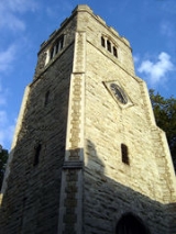
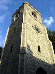
St Augustine's Tower Hackney
St Augustine's Tower stands in St John's Church Gardens, in Hackney Central, in the London Borough of Hackney, just off the southern end of the Narrow Way . It is all that remains of the early 16th century parish church of Hackney of St Augustine, which replaced the 13th century medieval church...
. The Borough contains 25 conservation area
Conservation area
A conservation areas is a tract of land that has been awarded protected status in order to ensure that natural features, cultural heritage or biota are safeguarded...
s including Clapton Square
Clapton Square
The Clapton Square Conservation Area, Hackney, was designated in 1969 and extended in 1991 & 2000. It is protected by Acts of Parliament as a London Square. It is dominated by the Church of St John-at-Hackney built in 1792-97, and St John’s Gardens. Its made up of listed late Georgian terraces on...
, and many urban open-spaces
Hackney parks and open spaces
The London Borough of Hackney, one of the inner London boroughs, has 62 parks, gardens and open spaces within its boundaries, totalling 330 ha. These provide the "green lungs" for leisure activities...
including Clapton Common and Clissold Park
Clissold Park
Clissold Park is a community park in Stoke Newington within the London Borough of Hackney. Facilities include a children's playground, sports fields, a bowling green, tennis courts, a cafe and some animal attractions including terrapins in its lakes...
. Conservation areas also protect large areas of Georgian
Georgian era
The Georgian era is a period of British history which takes its name from, and is normally defined as spanning the reigns of, the first four Hanoverian kings of Great Britain : George I, George II, George III and George IV...
and Victorian housing
Victorian era
The Victorian era of British history was the period of Queen Victoria's reign from 20 June 1837 until her death on 22 January 1901. It was a long period of peace, prosperity, refined sensibilities and national self-confidence...
, and areas of industrial heritage.
History
Metropolitan borough
A metropolitan borough is a type of local government district in England, and is a subdivision of a metropolitan county. Created in 1974 by the Local Government Act 1972, metropolitan boroughs are defined in English law as metropolitan districts, however all of them have been granted or regranted...
s of Hackney
Metropolitan Borough of Hackney
The Metropolitan Borough of Hackney was a Metropolitan borough of the County of London from 1900 to 1965. Its area became part of the London Borough of Hackney.-Formation and boundaries:...
, Shoreditch
Metropolitan Borough of Shoreditch
The Metropolitan Borough of Shoreditch was a Metropolitan borough of the County of London between 1900 and 1965, when it was merged with the Metropolitan Borough of Stoke Newington and the Metropolitan Borough of Hackney to form the London Borough of Hackney....
and Stoke Newington
Metropolitan Borough of Stoke Newington
The Metropolitan Borough of Stoke Newington was a metropolitan borough in the County of London between 1900 and 1965 when it became part of the London Borough of Hackney.-Predecessor authorities:...
. The new council adopted elements of its constituents in the new coat of arms; Shoreditch by three bells from Shoreditch Church
St Leonard's, Shoreditch
St Leonard's, Shoreditch is the ancient parish church of Shoreditch, often known simply as Shoreditch Church. It is located at the intersection of Shoreditch High Street with Hackney Road, within the London Borough of Hackney. The current building dates from about 1740...
(recalled in the rhyme Oranges and Lemons
Oranges and Lemons
"Oranges and Lemons" is an English nursery rhyme and singing game which refers to the bells of several churches, all within or close to the City of London. It is listed in the Roud Folk Song Index as #3190.-Lyrics:Common modern versions include:...
), Stoke Newington by two trees bearing fruit, and Hackney by the eight-pointed Maltese Cross
Maltese cross
The Maltese cross, also known as the Amalfi cross, is identified as the symbol of an order of Christian warriors known as the Knights Hospitaller or Knights of Malta and through them came to be identified with the Mediterranean island of Malta and is one of the National symbols of Malta...
of the principal landowners of the parish
Hackney (parish)
Hackney was a parish in the historic county of Middlesex. The parish church of St John-at-Hackney was built in 1789, replacing the nearby former 16th century parish church dedicated to St Augustine . The original tower of that church was retained to hold the bells until the new church could be...
in the Middle Ages
Middle Ages
The Middle Ages is a periodization of European history from the 5th century to the 15th century. The Middle Ages follows the fall of the Western Roman Empire in 476 and precedes the Early Modern Era. It is the middle period of a three-period division of Western history: Classic, Medieval and Modern...
, the Order of St John of Jerusalem
Knights Hospitaller
The Sovereign Military Hospitaller Order of Saint John of Jerusalem of Rhodes and of Malta , also known as the Sovereign Military Order of Malta , Order of Malta or Knights of Malta, is a Roman Catholic lay religious order, traditionally of military, chivalrous, noble nature. It is the world's...
. The shield is surmounted by a representation of St Augustin's Tower
St Augustine's Tower Hackney
St Augustine's Tower stands in St John's Church Gardens, in Hackney Central, in the London Borough of Hackney, just off the southern end of the Narrow Way . It is all that remains of the early 16th century parish church of Hackney of St Augustine, which replaced the 13th century medieval church...
, the remains of Hackney's former parish church in the historical centre of Hackney
Hackney Central
Hackney Central is the central district of the London Borough of Hackney in London, England. It comprises the area roughly surrounding, and extending north from Mare Street. It is situated north east of Charing Cross...
. The motto is Justitia turris nostra, translated as Being fair is what makes us strong. The Queen's
Elizabeth II of the United Kingdom
Elizabeth II is the constitutional monarch of 16 sovereign states known as the Commonwealth realms: the United Kingdom, Canada, Australia, New Zealand, Jamaica, Barbados, the Bahamas, Grenada, Papua New Guinea, the Solomon Islands, Tuvalu, Saint Lucia, Saint Vincent and the Grenadines, Belize,...
portrait hangs in the Council Chamber, wearing the robes of the Most Venerable Order of St John of Jerusalem
Venerable Order of Saint John
The Most Venerable Order of the Hospital of Saint John of Jerusalem , is a royal order of chivalry established in 1831 and found today throughout the Commonwealth of Nations, Hong Kong, Ireland and the United States of America, with the world-wide mission "to prevent and relieve sickness and...
of which she is the Sovereign Head.
Parts of the borough have a rich history. The Roman
Roman Britain
Roman Britain was the part of the island of Great Britain controlled by the Roman Empire from AD 43 until ca. AD 410.The Romans referred to the imperial province as Britannia, which eventually comprised all of the island of Great Britain south of the fluid frontier with Caledonia...
road, Ermine Street
Ermine Street
Ermine Street is the name of a major Roman road in England that ran from London to Lincoln and York . The Old English name was 'Earninga Straete' , named after a tribe called the Earningas, who inhabited a district later known as Armingford Hundred, around Arrington, Cambridgeshire and Royston,...
forms the western edge of the borough. Much of the rest of the land was covered with open oak and hazel woodlands, with marshland around the rivers and streams that crossed the area. Hackney lay in the Catuvellauni
Catuvellauni
The Catuvellauni were a tribe or state of south-eastern Britain before the Roman conquest.The fortunes of the Catuvellauni and their kings before the conquest can be traced through numismatic evidence and scattered references in classical histories. They are mentioned by Dio Cassius, who implies...
tribal territory. The eastern boundary of the borough is formed by the River Lea. This was an ancient boundary between pre-Roman tribes, and in the Roman era, was tidal as far as Hackney Wick
Hackney Wick
Hackney Wick is an area straddling the boundary between the London Borough of Hackney and the London Borough of Tower Hamlets in east London. It is an inner-city development situated 5 miles northeast of Charing Cross...
and continued as the boundary between the historic counties
Historic counties of England
The historic counties of England are subdivisions of England established for administration by the Normans and in most cases based on earlier Anglo-Saxon kingdoms and shires...
of Middlesex
Middlesex
Middlesex is one of the historic counties of England and the second smallest by area. The low-lying county contained the wealthy and politically independent City of London on its southern boundary and was dominated by it from a very early time...
and Essex
Essex
Essex is a ceremonial and non-metropolitan county in the East region of England, and one of the home counties. It is located to the northeast of Greater London. It borders with Cambridgeshire and Suffolk to the north, Hertfordshire to the west, Kent to the South and London to the south west...
.
Dissolution of the Monasteries
The Dissolution of the Monasteries, sometimes referred to as the Suppression of the Monasteries, was the set of administrative and legal processes between 1536 and 1541 by which Henry VIII disbanded monasteries, priories, convents and friaries in England, Wales and Ireland; appropriated their...
and Hackney became a retreat for nobility around Hackney Central
Hackney Central
Hackney Central is the central district of the London Borough of Hackney in London, England. It comprises the area roughly surrounding, and extending north from Mare Street. It is situated north east of Charing Cross...
and Homerton
Homerton
Homerton is a place in the London Borough of Hackney. It is bordered to the west by Hackney Central, to the north by Lower Clapton, in the east by Hackney Wick, Leyton and by South Hackney to the south.-Origins:...
, including Henry VIII
Henry VIII of England
Henry VIII was King of England from 21 April 1509 until his death. He was Lord, and later King, of Ireland, as well as continuing the nominal claim by the English monarchs to the Kingdom of France...
's palace by the Lea Bridge roundabout
Lower Clapton
Lower Clapton is a district within the London Borough of Hackney.It is immediately adjacent to central Hackney - bounded, roughly, by the western side of Hackney Downs , the Lea Valley , Clifden Road and the Lea Bridge Road...
, where BSix Sixth Form College
BSix Sixth Form College
BSix Sixth Form College: Brooke House is a sixth form college located in Upper Clapton, London in the United Kingdom. It officially opened in September 2002, giving students in Hackney the opportunity to study at a college close to where they live. Brooke House has previously been the site of other...
stands today. Sutton House, on Homerton High Street, is the oldest surviving dwelling in Hackney, originally built as Bryck Place for Tudor diplomat Sir Ralph Sadleir in 1535. The village of Hackney flourished from the Tudor to late Georgian periods as a rural retreat – brought to an end by the construction of the railway in the 1850s. Notable residents have included Robert Aske
Robert Aske (merchant)
Robert Aske was a merchant in the City of London. He is chiefly remembered from the charitable foundation created from his estate, which operates two schools in Hertfordshire, Haberdashers' Aske's Boys' School and Haberdashers' Aske's School for Girls.Aske was the son of an affluent draper...
, Samuel Courtauld
Samuel Courtauld (industrialist)
Samuel Courtauld was an industrialist and Unitarian, chiefly remembered as the driving force behind the rapid growth of the Courtauld textile business in Britain....
, Joseph Priestly Governor of the Bank of England
Bank of England
The Bank of England is the central bank of the United Kingdom and the model on which most modern central banks have been based. Established in 1694, it is the second oldest central bank in the world...
and the founding director of the Honourable East India Company, and Thomas Sutton
Thomas Sutton
Thomas Sutton was an English civil servant and businessman as well as being the founder of Charterhouse School. He was the son of an official of the city of Lincoln, and was educated at Eton College and probably at Cambridge...
.
English Renaissance theatre
English Renaissance theatre, also known as early modern English theatre, refers to the theatre of England, largely based in London, which occurred between the Reformation and the closure of the theatres in 1642...
were built in Shoreditch
Shoreditch
Shoreditch is an area of London within the London Borough of Hackney in England. It is a built-up part of the inner city immediately to the north of the City of London, located east-northeast of Charing Cross.-Etymology:...
and the Gunpowder Plot
Gunpowder Plot
The Gunpowder Plot of 1605, in earlier centuries often called the Gunpowder Treason Plot or the Jesuit Treason, was a failed assassination attempt against King James I of England and VI of Scotland by a group of provincial English Catholics led by Robert Catesby.The plan was to blow up the House of...
was first exposed at nearby Hoxton
Hoxton
Hoxton is an area in the London Borough of Hackney, immediately north of the financial district of the City of London. The area of Hoxton is bordered by Regent's Canal on the north side, Wharf Road and City Road on the west, Old Street on the south, and Kingsland Road on the east.Hoxton is also a...
. Many grand houses stood in Stoke Newington
Stoke Newington
Stoke Newington is a district in the London Borough of Hackney. It is north-east of Charing Cross.-Boundaries:In modern terms, Stoke Newington can be roughly defined by the N16 postcode area . Its southern boundary with Dalston is quite ill-defined too...
and Stamford Hill
Stamford Hill
Stamford Hill is a place in the north of the London Borough of Hackney, England, near the border with Haringey. It is home to Europe's largest Hasidic Jewish and Adeni Jewish community.Stamford Hill is NNE of Charing Cross.-History:...
, with the latter providing a haven for Hackney's many orthodox Jewish residents from the 1930s. Alfred Hitchcock
Alfred Hitchcock
Sir Alfred Joseph Hitchcock, KBE was a British film director and producer. He pioneered many techniques in the suspense and psychological thriller genres. After a successful career in British cinema in both silent films and early talkies, Hitchcock moved to Hollywood...
made many of his first films in Hoxton at the Gainsborough Studios in Poole Street.
After industrialisation, extensive post-war development and immigration, the area's many Georgian and Victorian terraces are being gentrified, warehouses are being converted and new apartments are being built. It was inner London's 'greenest borough' and London Transport's 'best bike borough 2006', with 62 parks and open spaces
Hackney parks and open spaces
The London Borough of Hackney, one of the inner London boroughs, has 62 parks, gardens and open spaces within its boundaries, totalling 330 ha. These provide the "green lungs" for leisure activities...
, covering 815 acres (3.3 km²). Seven Hackney parks have now achieved Green Flag
Green Flag award
The Green Flag Award is the benchmark national standard for parks and green spaces in the United Kingdom. The scheme was set up in 1996 to recognise and reward green spaces in England and Wales that met the laid down high standards...
status. One, Abney Park
Abney Park Cemetery
Abney Park in Stoke Newington, in the London Borough of Hackney, is a historic parkland originally laid out in the early 18th century by Lady Mary Abney and Dr. Isaac Watts, and the neighbouring Hartopp family. In 1840 it became a non-denominational garden cemetery, semi-public park arboretum, and...
, became scheduled in 2009 as one of Britain's historic park and garden at risk from neglect and decay. Hackney Marshes
Hackney Marshes
Hackney Marshes is an area of grassland on the western bank of the River Lea in the London Borough of Hackney. It was incorporated into the Lee Valley Park in 1967...
play host to the largest collection of football pitches in Europe; and will be the site of part of the 2012 Summer Olympics
2012 Summer Olympics
The 2012 Summer Olympic Games, officially known as the "London 2012 Olympic Games", are scheduled to take place in London, England, United Kingdom from 27 July to 12 August 2012...
.
Governance
Diane Abbott
Diane Julie Abbott is a British Labour Party politician who has been the Member of Parliament for Hackney North and Stoke Newington since 1987, when she became the first black woman to be elected to the House of Commons...
) and Hackney South and Shoreditch (represented by Meg Hillier MP
Meg Hillier
Margaret Olivia Hillier is a British Labour Co-operative politician who has been the Member of Parliament for Hackney South and Shoreditch since 2005, and was a junior Minister in HM Government from 2007 to 2010...
); both are Labour Party
Labour Party (UK)
The Labour Party is a centre-left democratic socialist party in the United Kingdom. It surpassed the Liberal Party in general elections during the early 1920s, forming minority governments under Ramsay MacDonald in 1924 and 1929-1931. The party was in a wartime coalition from 1940 to 1945, after...
Members of Parliament
Member of Parliament
A Member of Parliament is a representative of the voters to a :parliament. In many countries with bicameral parliaments, the term applies specifically to members of the lower house, as upper houses often have a different title, such as senate, and thus also have different titles for its members,...
. The borough is in the North East
North East (London Assembly constituency)
North East is a constituency of the London Assembly. It is represented by Jennette Arnold who was directly elected at the 2004 London Assembly election after previously being elected by the Labour Party list in the 2000 London Assembly election....
London Assembly
London Assembly
The London Assembly is an elected body, part of the Greater London Authority, that scrutinises the activities of the Mayor of London and has the power, with a two-thirds majority, to amend the mayor's annual budget. The assembly was established in 2000 and is headquartered at City Hall on the south...
constituency returning Jennette Arnold AM
Jennette Arnold
Jennette Arnold is a Labour Party politician and member of the London Assembly representing the London Boroughs of Hackney, Islington and Waltham Forest....
, as the directly elected Assembly Member. Hackney is part of the London constituency
London (European Parliament constituency)
London is a constituency of the European Parliament. It currently elects 8 MEPs using the d'Hondt method of party-list proportional representation.- Boundaries :The constituency corresponds to Greater London, in the south east of the United Kingdom....
in the European Parliament
European Parliament
The European Parliament is the directly elected parliamentary institution of the European Union . Together with the Council of the European Union and the Commission, it exercises the legislative function of the EU and it has been described as one of the most powerful legislatures in the world...
.
Unlike most other English local authorities, the Borough is now governed by a directly-elected Mayor
Elected mayors in the United Kingdom
Directly elected mayors are council leaders elected by the general electorate of a council area for local government, instead of being appointed by members of a local authority, which is common in the United Kingdom. The Elected Mayor is elected from a number of candidates who put themselves up for...
who is also the political leader of the council. The Mayor – currently Jules Pipe
Jules Pipe
Julian Benjamin Pipe CBE is the first directly elected Mayor of the London Borough of Hackney since his election in October 2002.He worked as a journalist until taking on the full-time position as Mayor....
CBE
CBE
CBE and C.B.E. are abbreviations for "Commander of the Order of the British Empire", a grade in the Order of the British Empire.Other uses include:* Chemical and Biochemical Engineering...
– is supported by a cabinet
Cabinet-style council
A Cabinet-style Council is a type of local government which has been introduced in the United Kingdom for Local Councils following the introduction of the Local Government Act 2000....
, councillor
Councillor
A councillor or councilor is a member of a local government council, such as a city council.Often in the United States, the title is councilman or councilwoman.-United Kingdom:...
s and a Speaker
Speaker (politics)
The term speaker is a title often given to the presiding officer of a deliberative assembly, especially a legislative body. The speaker's official role is to moderate debate, make rulings on procedure, announce the results of votes, and the like. The speaker decides who may speak and has the...
, currently Councillor Sally Mulready, who fulfils the civic and ceremonial duties previously undertaken by the (non-political) mayor.
At the Hackney Council election
Hackney Council election, 2010
Elections for London Borough of Hackney Council were held on Thursday 6 May 2010. The whole council was up for election. Hackney is split up into 19 wards, each electing 3 councillors, so a total of 57 seats were up for election.-Summary results:...
on 6 May 2010
London local elections, 2010
Local government elections took place in London, and some other parts of the United Kingdom on Thursday 6 May 2010. Polling stations were open between 7am and 10pm....
the Labour Party
Labour Party (UK)
The Labour Party is a centre-left democratic socialist party in the United Kingdom. It surpassed the Liberal Party in general elections during the early 1920s, forming minority governments under Ramsay MacDonald in 1924 and 1929-1931. The party was in a wartime coalition from 1940 to 1945, after...
were returned with 50 councillors; winning six additional seats. The Conservative Party
Conservative Party (UK)
The Conservative Party, formally the Conservative and Unionist Party, is a centre-right political party in the United Kingdom that adheres to the philosophies of conservatism and British unionism. It is the largest political party in the UK, and is currently the largest single party in the House...
forms the largest opposition party on the council with four councillors; and the Liberal Democrats
Liberal Democrats
The Liberal Democrats are a social liberal political party in the United Kingdom which supports constitutional and electoral reform, progressive taxation, wealth taxation, human rights laws, cultural liberalism, banking reform and civil liberties .The party was formed in 1988 by a merger of the...
have three.
Between 1999 and 2001 serious concerns were expressed about Hackney's performance as a Council by the Audit Commission
Audit Commission
The Audit Commission is a public corporation in the United Kingdom.The Commission’s primary objective is to improve economy, efficiency and effectiveness in local government, housing and the health service, directly through the audit and inspection process and also through value for money...
, and many aspects of council services were failing. This led to considerable negative press coverage that still colours perceptions of the area, but is at odds with the changing realities of the borough nowadays. In 2005, MORI
MORI
Ipsos MORI is the second largest market research organisation in the United Kingdom, formed by a merger of Ipsos UK and MORI, two of the Britain's leading survey companies in October 2005...
identified that residents were significantly more satisfied than they had been in 2002, and in 2007 the Audit Commission showed that improvements continue to be made in council performance, with the council now achieving 'three stars', and described as 'improving strongly'. Every ward remains among the 10% most deprived in the country, with 47% of children living in low income households.
Hackney has a reputation as one of the most crime-affected London boroughs, and some of its streets have even been called "Murder Mile", but cooperation between local police and council has resulted in the borough experiencing a bigger drop in crime than in any other London borough in the four year period up to 2007 (28% reduction).
Location
The London Borough of Hackney is an Inner LondonInner London
Inner London is the name for the group of London boroughs which form the interior part of Greater London and are surrounded by Outer London. The area was first officially defined in 1965 and for purposes such as statistics, the definition has changed over time. The terms Inner London and Central...
Borough
London borough
The administrative area of Greater London contains thirty-two London boroughs. Inner London comprises twelve of these boroughs plus the City of London. Outer London comprises the twenty remaining boroughs of Greater London.-Functions:...
within Greater London
Greater London
Greater London is the top-level administrative division of England covering London. It was created in 1965 and spans the City of London, including Middle Temple and Inner Temple, and the 32 London boroughs. This territory is coterminate with the London Government Office Region and the London...
. It is to the north-east of the City of London
City of London
The City of London is a small area within Greater London, England. It is the historic core of London around which the modern conurbation grew and has held city status since time immemorial. The City’s boundaries have remained almost unchanged since the Middle Ages, and it is now only a tiny part of...
; and neighboured by the London Boroughs of Tower Hamlets
London Borough of Tower Hamlets
The London Borough of Tower Hamlets is a London borough to the east of the City of London and north of the River Thames. It is in the eastern part of London and covers much of the traditional East End. It also includes much of the redeveloped Docklands region of London, including West India Docks...
, to the south; Islington
London Borough of Islington
The London Borough of Islington is a London borough in Inner London. It was formed in 1965 by merging the former metropolitan boroughs of Islington and Finsbury. The borough contains two Westminster parliamentary constituencies, Islington North and Islington South & Finsbury...
to the west at Southgate Road
Southgate Road
Southgate Road is a street that runs from Baring Street in the south to the junction with Mildmay Park and Ball's Pond Road in the north. The street forms a part of the B102 road, leading from Newington Green to The City. The west side of Southgate Road is in the London Borough of Islington; and...
; Haringey
London Borough of Haringey
The London Borough of Haringey is a London borough, in North London, classified by some definitions as part of Inner London, and by others as part of Outer London. It was created in 1965 by the amalgamation of three former boroughs. It shares borders with six other London boroughs...
to the north. On the east, the River Lea forms the boundary with Waltham Forest
London Borough of Waltham Forest
The London Borough of Waltham Forest is in northeast London, England. Officially, it forms part of Outer London as it borders Essex. However, it can be seen that the NE London boundary does not extend far compared to elsewhere in the city...
; and to the south-east is Newham
London Borough of Newham
The London Borough of Newham is a London borough formed from the towns of West Ham and East Ham, within East London.It is situated east of the City of London, and is north of the River Thames. According to 2006 estimates, Newham has one of the highest ethnic minority populations of all the...
. Historically, this river has formed a boundary between the former counties of Middlesex
Middlesex
Middlesex is one of the historic counties of England and the second smallest by area. The low-lying county contained the wealthy and politically independent City of London on its southern boundary and was dominated by it from a very early time...
and Essex
Essex
Essex is a ceremonial and non-metropolitan county in the East region of England, and one of the home counties. It is located to the northeast of Greater London. It borders with Cambridgeshire and Suffolk to the north, Hertfordshire to the west, Kent to the South and London to the south west...
.
Hackney Town Hall is about 5 miles (8 km) north-east of Charing Cross
Charing Cross
Charing Cross denotes the junction of Strand, Whitehall and Cockspur Street, just south of Trafalgar Square in central London, England. It is named after the now demolished Eleanor cross that stood there, in what was once the hamlet of Charing. The site of the cross is now occupied by an equestrian...
; and 3.8 miles (6.1 km) from the GLA
Greater London Authority
The Greater London Authority is the top-tier administrative body for Greater London, England. It consists of a directly elected executive Mayor of London, currently Boris Johnson, and an elected 25-member London Assembly with scrutiny powers...
City Hall
City Hall (London)
City Hall is the headquarters of the Greater London Authority which comprises the Mayor of London and London Assembly. It is located in Southwark, on the south bank of the River Thames near Tower Bridge...
near Tower Bridge
Tower Bridge
Tower Bridge is a combined bascule and suspension bridge in London, England, over the River Thames. It is close to the Tower of London, from which it takes its name...
.
Districts and postcodes
The most southerly district in the borough is Shoreditch
Shoreditch
Shoreditch is an area of London within the London Borough of Hackney in England. It is a built-up part of the inner city immediately to the north of the City of London, located east-northeast of Charing Cross.-Etymology:...
, adjacent to the City. To the north-west, bordering Islington, the City, and north of Old Street
Old Street
Old Street is a street in east London that runs west to east from Goswell Road in Clerkenwell, in the London Borough of Islington, to the crossroads where it intersects with Shoreditch High Street , Kingsland Road and Hackney Road in Shoreditch in the London Borough of Hackney.The nearest...
is Hoxton
Hoxton
Hoxton is an area in the London Borough of Hackney, immediately north of the financial district of the City of London. The area of Hoxton is bordered by Regent's Canal on the north side, Wharf Road and City Road on the west, Old Street on the south, and Kingsland Road on the east.Hoxton is also a...
. To the north of Shoreditch is Haggerston
Haggerston
Haggerston is an area and a electoral ward in the London Borough of Hackney, in northeast London, UK. It is bounded by Hackney Road on the south, Kingsland Road on the west, Middleton Road on the north with London Fields and Broadway Market on the east...
, north of the Regents Canal. Bethnal Green also forms of the southern parts of the borough, also this is formally and majoritised within neighbouring Tower Hamlets.
Settlements to the west of the borough followed the line of the former Ermine Street
Ermine Street
Ermine Street is the name of a major Roman road in England that ran from London to Lincoln and York . The Old English name was 'Earninga Straete' , named after a tribe called the Earningas, who inhabited a district later known as Armingford Hundred, around Arrington, Cambridgeshire and Royston,...
, with De Beauvoir Town
De Beauvoir Town
De Beauvoir Town is a district of the London Borough of Hackney that partly falls within the London Borough of Islington. Its borders are Kingsland Road in the east, Southgate Road to the west, the Regent's Canal in the south and Tottenham Road to the north...
— a Victorian
Victorian era
The Victorian era of British history was the period of Queen Victoria's reign from 20 June 1837 until her death on 22 January 1901. It was a long period of peace, prosperity, refined sensibilities and national self-confidence...
estate to the west of the (now) Kingsland Road
Kingsland Road
Kingsland Road is the name of a road, part of the A10, in the London Borough of Hackney in England. It runs from the junction with Old Street and Hackney Road north to the junction with Balls Pond Road and Dalston Lane, where it changes its name to Kingsland High Street...
. Further north, lie Dalston
Dalston
Dalston is a district of north-east London, England, located in the London Borough of Hackney. It is situated northeast of Charing Cross. The area is identified in the London Plan as one of 35 major centres in Greater London...
, Stoke Newington
Stoke Newington
Stoke Newington is a district in the London Borough of Hackney. It is north-east of Charing Cross.-Boundaries:In modern terms, Stoke Newington can be roughly defined by the N16 postcode area . Its southern boundary with Dalston is quite ill-defined too...
and Stamford Hill
Stamford Hill
Stamford Hill is a place in the north of the London Borough of Hackney, England, near the border with Haringey. It is home to Europe's largest Hasidic Jewish and Adeni Jewish community.Stamford Hill is NNE of Charing Cross.-History:...
— where the borough meets Haringey.
A further group of settlements follow another north-south radial road, with South Hackney
South Hackney
South Hackney is a district in the London Borough of Hackney situated north east of Charing Cross.It is immediately north of Victoria Park and the area centred on Victoria Park Road and Lauriston Road...
to the east of Cambridge Heath Road — north of Victoria Park
Victoria Park, East London
Victoria Park is 86.18 hectares of open space that stretches out across part of the East End of London, England bordering parts of Bethnal Green, Hackney, and Bow, such as along Old Ford Road, London E3 and Victoria Park Road E9. The park is entirely within the London Borough of Tower Hamlets...
; and Hackney Central
Hackney Central
Hackney Central is the central district of the London Borough of Hackney in London, England. It comprises the area roughly surrounding, and extending north from Mare Street. It is situated north east of Charing Cross...
commencing where this street becomes Mare Street. London Fields
London Fields
London Fields is a park and the name of an area of London, situated in the eastern borough of Hackney. The park itself was first recorded in 1540. At this time it was common ground and was used by drovers to pasture their livestock before taking them to market in London.London Fields is just over ...
was common land
Common land
Common land is land owned collectively or by one person, but over which other people have certain traditional rights, such as to allow their livestock to graze upon it, to collect firewood, or to cut turf for fuel...
to the west of this point, but now forms a district in its own right. To the north, Homerton
Homerton
Homerton is a place in the London Borough of Hackney. It is bordered to the west by Hackney Central, to the north by Lower Clapton, in the east by Hackney Wick, Leyton and by South Hackney to the south.-Origins:...
lies immediately east of the centre of Hackney. The borough boundary to the east is formed by the River Lea. Hackney Wick
Hackney Wick
Hackney Wick is an area straddling the boundary between the London Borough of Hackney and the London Borough of Tower Hamlets in east London. It is an inner-city development situated 5 miles northeast of Charing Cross...
, the Hackney Marshes
Hackney Marshes
Hackney Marshes is an area of grassland on the western bank of the River Lea in the London Borough of Hackney. It was incorporated into the Lee Valley Park in 1967...
, Lower
Lower Clapton
Lower Clapton is a district within the London Borough of Hackney.It is immediately adjacent to central Hackney - bounded, roughly, by the western side of Hackney Downs , the Lea Valley , Clifden Road and the Lea Bridge Road...
and Upper Clapton
Upper Clapton
Upper Clapton is a district in the London Borough of Hackney. It is bounded by the Hackney districts of Stamford Hill to the west, Lower Clapton and Lea Bridge to the south and the Haringey district of South Tottenham to the north...
all lie along the this eastern boundary.
Postal districts
London postal district
The London postal district is the area in England, currently of , to which mail addressed to the LONDON post town is delivered. The area was initially devised in 1856 and throughout its history has been subject to periodic reorganisation, contraction and division into increasingly smaller postal...
were assigned to the former parts of the borough in 1857/8. Most of the borough would originally have been covered by a planned 'NE' postal district, but this was abolished in 1866. Most of the borough is covered by the eastern postal district, but Shoreditch benefits from five separate postcodes. Areas to the west of Kingsland Road and in the north of the borough are predominantly covered by the northern postal district
N postcode area
The N postcode area, also known as the London N postcode area, is the part of the London post town covering part of North London, England....
.
Traditionally, much of the borough was considered a part of east London, with Hoxton and Shoreditch being part of the East End of London
East End of London
The East End of London, also known simply as the East End, is the area of London, England, United Kingdom, east of the medieval walled City of London and north of the River Thames. Although not defined by universally accepted formal boundaries, the River Lea can be considered another boundary...
. In the 2008 revision of the London Plan
London Plan
The London Plan is a planning document written by the Mayor of London, England in the United Kingdom and published by the Greater London Authority. The plan was first published in final form on 10 February 2004 and has since been amended. The current version was published in February 2008...
, the borough was reassigned to the north London sub-region
North (London sub region)
The North is a sub-region of the London Plan corresponding to the London Boroughs of Barnet, Camden, Enfield, Hackney, Haringey, Islington and Westminster. The sub region was established in 2004, consisting of Barnet, Enfield, Haringey and Waltham Forest...
.
Topography
The London Borough of Hackney covers an area of 19.06 square kilometres (7.4 sq mi). Its primary geographic feature is the course of the River Lea; and the associated River Lee NavigationRiver Lee Navigation
The Lee Navigation is a canalised river incorporating the River Lea . Its course runs from Hertford Castle Weir all the way to the River Thames at Bow Creek. The first lock of the navigation is Hertford Lock the last being Bow Locks....
, which passes through Hackney Cut
Hackney Cut
The Hackney Cut is an artificial channel of the River Lee Navigation built in 1770 by the River Lea Trustees to straighten and improve the Navigation. It begins at by the Middlesex Filter Beds Weir, below Lea Bridge...
— an artificial channel of the Lea built in 1770 across the Hackney Marshes
Hackney Marshes
Hackney Marshes is an area of grassland on the western bank of the River Lea in the London Borough of Hackney. It was incorporated into the Lee Valley Park in 1967...
to straighten a meander of the natural river. A tributary of the Lea, Hackney Brook
Hackney Brook
The Hackney Brook is one of the subterranean rivers of London. It crossed the northern parts of the current London boroughs of Hackney and Islington, emptying into the River Lea at Hackney Wick, with its source in Holloway.- Course of the River :...
was fully culverted in 1860 by the Metropolitan Board of Works
Metropolitan Board of Works
The Metropolitan Board of Works was the principal instrument of London-wide government from 1855 until the establishment of the London County Council in 1889. Its principal responsibility was to provide infrastructure to cope with London's rapid growth, which it successfully accomplished. The MBW...
.
The New River
New River (England)
The New River is an artificial waterway in England, opened in 1613 to supply London with fresh drinking water taken from the River Lea and from Amwell Springs , and other springs and wells along its course....
passes through the Borough from near Finsbury Park
Finsbury Park
Finsbury Park is a 46 hectare public park in the London Borough of Haringey. Officially part of the London area of Harringay, it is also adjacent to Stroud Green, the Finsbury Park district and Manor House. It was one of the first of the great London parks laid out in the Victorian...
, and flows towards Islington. The Regents Canal also crosses the Borough below De Beauvoir Town in the west, joining the Hertford Union Canal
Hertford Union Canal
The Hertford Union Canal or Duckett's Canal is a short stretch of canal in the London Borough of Tower Hamlets in east London. It connects the Regent's Canal to the Lee Navigation. It was opened in 1830 but quickly proved to be a commercial failure...
below Victoria Park.
Within the Borough, the land rises westward from the Lea reaching 30 metres (98.4 ft) above sea level at Clapton Common and Stamford Hill
Stamford Hill
Stamford Hill is a place in the north of the London Borough of Hackney, England, near the border with Haringey. It is home to Europe's largest Hasidic Jewish and Adeni Jewish community.Stamford Hill is NNE of Charing Cross.-History:...
. The area around Victoria Park, in the south of the borough lies about 15 metres (49.2 ft) above sea level. At Spring Hill, in Upper Clapton
Upper Clapton
Upper Clapton is a district in the London Borough of Hackney. It is bounded by the Hackney districts of Stamford Hill to the west, Lower Clapton and Lea Bridge to the south and the Haringey district of South Tottenham to the north...
the road descends sharply from 25 metres (82 ft) to only 10 metres (32.8 ft) at High Hill Ferry, on the Lee Navigation.
Geology
The Lea and Hackney Marsh are underlain by alluvium soilsAlluvium
Alluvium is loose, unconsolidated soil or sediments, eroded, deposited, and reshaped by water in some form in a non-marine setting. Alluvium is typically made up of a variety of materials, including fine particles of silt and clay and larger particles of sand and gravel...
; and the higher ground between Homerton and Stamford Hill is formed on a widening bed of London Clay
London Clay
The London Clay Formation is a marine geological formation of Ypresian age which crops out in the southeast of England. The London Clay is well known for the fossils it contains. The fossils from the Lower Eocene indicate a moderately warm climate, the flora being tropical or subtropical...
. Brickearth
Brickearth
Brickearth is a term used in southeast England for loess, a wind-blown dust deposited under extremely cold, dry, peri- or postglacial conditions. The name arises from its use in making house bricks. The Brickearth is normally represented on 1:50,000 solid and drift edition geological maps...
deposits are within tongues of clay extending beneath Clapton Common, Stamford Hill and Stoke Newington High Street. The centre and south western districts lie on river terrace deposits of Taplow Gravel. Victoria Park and Well Street Common are on flood plain gravel.
Climate
This data was taken between 1971 and 2000 at the nearest national weather station in GreenwichGreenwich
Greenwich is a district of south London, England, located in the London Borough of Greenwich.Greenwich is best known for its maritime history and for giving its name to the Greenwich Meridian and Greenwich Mean Time...
; around 7 miles (11.3 km) south of Hackney Town hall:
Demography
In 1801, the civil parishes that form the modern borough had a total population of 14,609. This rose steadily throughout the 19th century, as the district became built up; reaching 95,000 in the middle of the century. When the railways arrived the rate of population growthPopulation growth
Population growth is the change in a population over time, and can be quantified as the change in the number of individuals of any species in a population using "per unit time" for measurement....
increased — reaching nearly 374,000 by the turn of the century. This increase in population peaked before World War I
World War I
World War I , which was predominantly called the World War or the Great War from its occurrence until 1939, and the First World War or World War I thereafter, was a major war centred in Europe that began on 28 July 1914 and lasted until 11 November 1918...
, falling slowly in the aftermath until World War II
World War II
World War II, or the Second World War , was a global conflict lasting from 1939 to 1945, involving most of the world's nations—including all of the great powers—eventually forming two opposing military alliances: the Allies and the Axis...
began an exodus from London towards the new towns
New towns in the United Kingdom
Below is a list of some of the new towns in the United Kingdom created under the various New Town Acts of the 20th century. Some earlier towns were developed as Garden Cities or overspill estates early in the twentieth century. The New Towns proper were planned to disperse population following the...
under the Abercrombie Plan for London
Patrick Abercrombie
Sir Leslie Patrick Abercrombie ) was an English town planner. Educated at Uppingham School, Rutland; brother of Lascelles Abercrombie, poet and literary critic.-Career:...
(1944). The population is now rising again, and the 2001 census
United Kingdom Census 2001
A nationwide census, known as Census 2001, was conducted in the United Kingdom on Sunday, 29 April 2001. This was the 20th UK Census and recorded a resident population of 58,789,194....
gives Hackney a population of 202,824.
The population is ethnically diverse. Of the resident population, 89,490 (40%) people describe themselves as White British. 30,978 (15%) are in other White ethnic group
Ethnic group
An ethnic group is a group of people whose members identify with each other, through a common heritage, often consisting of a common language, a common culture and/or an ideology that stresses common ancestry or endogamy...
s, 63,009 (30%) are Black or Black British, 20,000 (9.4%) are Asian or Asian British, 8,501 (4%) describe themselves as 'Mixed', and 6,432 (3%) as Chinese or Other.
There is also a large Turkish and Kurdish population in Hackney. Turkish and Kurdish communities are located in all parts of the Borough, though there is a greater concentration in the north and in central Hackney. Stoke Newington
Stoke Newington
Stoke Newington is a district in the London Borough of Hackney. It is north-east of Charing Cross.-Boundaries:In modern terms, Stoke Newington can be roughly defined by the N16 postcode area . Its southern boundary with Dalston is quite ill-defined too...
, Newington Green
Newington Green
Newington Green is an open space in north London which straddles the border between Islington and Hackney. It gives its name to the surrounding area, roughly bounded by Ball's Pond Road to the south, Petherton Road to the west, the southern section of Stoke Newington with Green Lanes-Matthias Road...
(London Borough of Islington) and Dalston
Dalston
Dalston is a district of north-east London, England, located in the London Borough of Hackney. It is situated northeast of Charing Cross. The area is identified in the London Plan as one of 35 major centres in Greater London...
have the greatest concentration of population and in particular Stoke Newington Road and Green Lanes have a high concentration of businesses and shops.
132,931 (66%) of the resident population were born in the UK. A further 10,095 (5%) were born in other parts of Europe, and the remaining 59,798 (29%) born elsewhere in the world.
The 2001 census also shows Christianity is the biggest religion in Hackney, with (44%) Christian; (18%) Muslim; (4%) Jewish; and (3%) belong to other religions. A further (19%) stated no religion, and (12%) did not state a religion.
32% of householders are owner–occupiers.
Education
In 2002, the borough entered into a ten year contract withthe Learning Trust, an independent collaborative body that organises education for Hackney's 27,000 pupils in over 70 schools, nurseries and play centres. The trust was set up in response to an OFSTED
Ofsted
The Office for Standards in Education, Children's Services and Skills is the non-ministerial government department of Her Majesty's Chief Inspector of Schools In England ....
report that identified failings in the then existing system. Two of London's most successful City Academies are in Hackney with another two in development and plans to rebuild or renovate every other Hackney school by 2016.
Transport
Hackney is currently served by London UndergroundLondon Underground
The London Underground is a rapid transit system serving a large part of Greater London and some parts of Buckinghamshire, Hertfordshire and Essex in England...
services: Manor House
Manor House tube station
Manor House tube station is a station on the Piccadilly line of the London Underground, on the boundary between Travelcard Zone 2 and Zone 3. It straddles the border between the London Boroughs of Hackney and Haringey, the postal address and three of the entrances being in the former, and one...
which is located in the Borough, on its extreme north-western fringe on the boundary with Haringey
London Borough of Haringey
The London Borough of Haringey is a London borough, in North London, classified by some definitions as part of Inner London, and by others as part of Outer London. It was created in 1965 by the amalgamation of three former boroughs. It shares borders with six other London boroughs...
. Old Street sits only a few yards south-west of the Borough in Islington
London Borough of Islington
The London Borough of Islington is a London borough in Inner London. It was formed in 1965 by merging the former metropolitan boroughs of Islington and Finsbury. The borough contains two Westminster parliamentary constituencies, Islington North and Islington South & Finsbury...
.
Two London Overground
London Overground
London Overground is a suburban rail network in London and Hertfordshire. It has been operated by London Overground Rail Operations since 2007 as part of the National Rail network, under the franchise control and branding of Transport for London...
lines serve the borough. North London Line
North London Line
The North London Line is a railway line which passes through the inner suburbs of north London, England. Its route is a rough semicircle from the south west to the north east, avoiding central London. The line is owned and maintained by Network Rail...
crosses from west to east while East London Line
East London Line
The East London Line is a London Overground line which runs north to south through the East End, Docklands and South areas of London.Built in 1869 by the East London Railway Company, which reused the Thames Tunnel, originally intended for horse-drawn carriages, the line became part of the London...
starts from Highbury & Islington and passes through Dalston Junction
Dalston Junction railway station
Dalston Junction railway station is in the Dalston area of the London Borough of Hackney at the crossroad of Dalston Lane, Kingsland Road and Balls Pond Road...
and en route south through Haggerston, Hoxton, Shoreditch and on south of the river to Lewisham. The Lea Valley Lines
Lea Valley Lines
The Lea Valley Lines are three commuter lines and two branches in North East London, so named because they run along the valley of the River Lea...
also pass through Hackney. The Liverpool Street to Enfield line passes through the borough and stops in Hackney at Cambridge Heath, London Fields, Hackney Downs, Rectory Road, Stoke Newington and Stamford Hill
Crossrail 2 would provide a direct Underground line to serve Hackney, Dalston and Homerton although it is currently undecided whether this would be operated by London Underground or as a main line.
London Overground
North London LineNorth London Line
The North London Line is a railway line which passes through the inner suburbs of north London, England. Its route is a rough semicircle from the south west to the north east, avoiding central London. The line is owned and maintained by Network Rail...
Travelling west to east — nearest London Overground stations
London Overground
London Overground is a suburban rail network in London and Hertfordshire. It has been operated by London Overground Rail Operations since 2007 as part of the National Rail network, under the franchise control and branding of Transport for London...
are Dalston Kingsland
Dalston Kingsland railway station
Dalston Kingsland railway station is a railway station on the North London Line in London, England. It is in the Dalston area of the London Borough of Hackney, on the western side of Kingsland High Street and opposite Ridley Road Market. The station and all trains serving it are operated by London...
, Hackney Central
Hackney Central railway station
Hackney Central railway station is a railway station on the North London Line in an area of the London Borough of Hackney known as Hackney Central in east London. It is between and , in Travelcard Zone 2. The station and all trains serving it are operated by London Overground.The station is a...
, Homerton
Homerton railway station
Homerton railway station is in the London Borough of Hackney in east London. It is on the North London Line, and the station and all trains serving it are operated by London Overground...
and Hackney Wick
Hackney Wick railway station
Hackney Wick railway station is on the North London Line in the London Borough of Hackney, on the northern side of the boundary between Hackney and the London Borough of Tower Hamlets, in east London. It is in Travelcard Zone 2. The station and all trains serving it are operated by London Overground...
East London Line
East London Line
The East London Line is a London Overground line which runs north to south through the East End, Docklands and South areas of London.Built in 1869 by the East London Railway Company, which reused the Thames Tunnel, originally intended for horse-drawn carriages, the line became part of the London...
Travelling north to south — nearest London Overground stations
London Overground
London Overground is a suburban rail network in London and Hertfordshire. It has been operated by London Overground Rail Operations since 2007 as part of the National Rail network, under the franchise control and branding of Transport for London...
are Dalston Junction
Dalston Junction railway station
Dalston Junction railway station is in the Dalston area of the London Borough of Hackney at the crossroad of Dalston Lane, Kingsland Road and Balls Pond Road...
, Haggerston
Haggerston railway station
Haggerston railway station is in the London Borough of Hackney, in London. The station is located on the Kingsland Viaduct in the Haggerston district at the junction of Arbutus Street and Frederick Terrace, near Kingsland Road. The main entrance is in Lee Street...
, Hoxton
Hoxton railway station
Hoxton railway station is in the Hoxton district of the London Borough of Hackney. The station is located on the Kingsland Viaduct and is served by London Overground trains on the extended East London Line, under the control of the London Rail division of Transport for London...
and Shoreditch High Street
Shoreditch High Street railway station
Shoreditch High Street is a railway station in Shoreditch, London. The station is located on Bethnal Green Road close to Shoreditch High Street and is served by London Overground services running on the extended East London Line under the control of the London Rail division of Transport for London...
Lea Valley Lines
These stations are served by National Express East Anglia:- Stamford Hill railway stationStamford Hill railway stationStamford Hill is a railway station in Stamford Hill, in the London Borough of Hackney, east London.The entrance hall of Stamford Hill railway station on Amhurst Park lies within the London Borough of Hackney, but the platform area lies within Tottenham in the London Borough of Haringey in north...
- Stoke Newington railway stationStoke Newington railway stationStoke Newington railway station links Stoke Newington to Liverpool Street in central London, and to Cheshunt and Enfield Town further north. Trains generally run every fifteen minutes....
- Rectory Road railway stationRectory Road railway stationRectory Road railway station is a railway station in Stoke Newington in the London Borough of Hackney, North London, United Kingdom.It is located on the Seven Sisters branch of the Lea Valley Lines, between Stoke Newington and Hackney Downs...
- Clapton railway stationClapton railway stationClapton railway station is on a suburban line operated by National Express East Anglia located on Upper Clapton Road.It links Upper Clapton to Liverpool Street in central London and Chingford....
- Hackney Downs railway stationHackney Downs railway stationHackney Downs railway station is in the London Borough of Hackney in east London. The station, and all trains serving it, is operated by National Express East Anglia, on the West Anglia route, and it is in Travelcard Zone 2....
- London Fields railway stationLondon Fields railway stationLondon Fields railway station is in the London Borough of Hackney in east London. It is 4 km north east of London Liverpool Street on the West Anglia route...
Notable attractions and institutions
- Arcola TheatreArcola TheatreArcola Theatre is a studio theatre in Dalston, in the London Borough of Hackney. The theatre's ambition is to create and present high-quality theatre with a social and political relevance to its multicultural local community as well as a wider audience....
- studio theatre - The Circus SpaceThe Circus SpaceThe Circus Space in the Hoxton area of London offers the UK's only university degree programme in circus. It supports the professional development of circus performers and circus companies and runs youth and adult evening classes every week...
- circus school - Geffrye MuseumGeffrye MuseumFounded in 1914, the Geffrye Museum is a museum specialising in the history of the English domestic interior. Named after Sir Robert Geffrye, former Lord Mayor of London and Master of the Ironmongers' Company, it is located on Kingsland Road in London...
- decorative arts museum - Hackney EmpireHackney EmpireThe Hackney Empire is a theatre on Mare Street, in the London Borough of Hackney, built in 1901 as a music hall.-History:Hackney Empire is a grade II* listed building...
- theatre - Hoxton HallHoxton HallHoxton Hall is a community centre and performance space in Hoxton, at 130 Hoxton Street, in the London Borough of Hackney.A grade II* listed building, the theatre was first built as a Music hall in 1863, as MacDonald's Music hall. It is an unrestored example of the saloon-style...
- community centre and performance space - Newington Green Unitarian ChurchNewington Green Unitarian ChurchNewington Green Unitarian Church in north London is one of England's oldest Unitarian churches. It has had strong ties to political radicalism for over 300 years, and is London's oldest Nonconformist place of worship still in use...
- London's oldest nonconformist place of worship - St John the Baptist, HoxtonSt John the Baptist, HoxtonThe Church of St John the Baptist, Hoxton, usually known as St John's Hoxton, is an urban Anglican church in Hoxton, Hackney, a host borough of London2012....
- Anglican church (from where "Amazing GraceAmazing Grace"Amazing Grace" is a Christian hymn with words written by the English poet and clergyman John Newton , published in 1779. With a message that forgiveness and redemption are possible regardless of the sins people commit and that the soul can be delivered from despair through the mercy of God,...
" derived) - Sutton House - Heritage house and museum
- Transition GalleryTransition GalleryTransition Gallery is a contemporary art project space in Hackney, East London. It is run by artists Cathy Lomax and Alex Michon. Transition Editions the gallery's publishing arm produces publications to accompany shows as well as two bi-annual magazines Arty and Garageland.-History:Transition...
- contemporary art project space - Victoria Miro GalleryVictoria Miro GalleryThe Victoria Miro Gallery is a leading British contemporary art gallery in London, with an international reputation, run by Victoria Miro, one of the "grandes dames of the Britart scene", who first exhibited Chris Ofili and the Chapman Brothers...
- contemporary art gallery - Vortex Jazz ClubVortex Jazz ClubThe Vortex Jazz Club is a London venue that primarily features live contemporary jazz. The club's official website features book reviews and jazz CD reviews by critic Chris Parker....
- live jazz venue - White CubeWhite CubeWhite Cube is a contemporary art gallery designed by MRJ Rundell & Associates in Hoxton Square in the East End of London Mason's Yard, in central London and White Cube Bermondsey in South East London...
- contemporary commercial art gallery - [Abney Park Cemetry]- fine overgrown Victorian cemetry and Nature Reserve
Twinned towns
The London Borough of Hackney has formal twinningTown twinning
Twin towns and sister cities are two of many terms used to describe the cooperative agreements between towns, cities, and even counties in geographically and politically distinct areas to promote cultural and commercial ties.- Terminology :...
arrangements with:
| Flag | Country | Town | Region |
|---|---|---|---|
 Barbados Barbados |
Barbados Barbados Barbados is an island country in the Lesser Antilles. It is in length and as much as in width, amounting to . It is situated in the western area of the North Atlantic and 100 kilometres east of the Windward Islands and the Caribbean Sea; therein, it is about east of the islands of Saint... |
Bridgetown Bridgetown The city of Bridgetown , metropolitan pop 96,578 , is the capital and largest city of the nation of Barbados. Formerly, the Town of Saint Michael, the Greater Bridgetown area is located within the parish of Saint Michael... |
Caribbean Caribbean The Caribbean is a crescent-shaped group of islands more than 2,000 miles long separating the Gulf of Mexico and the Caribbean Sea, to the west and south, from the Atlantic Ocean, to the east and north... |
 France France |
France | Suresnes Suresnes Suresnes is a commune in the western suburbs of Paris, France. It is located from the center of Paris. The nearest communes are Neuilly-sur-Seine, Puteaux, Rueil-Malmaison, Saint-Cloud and Boulogne-Billancourt... |
Western Paris Paris Paris is the capital and largest city in France, situated on the river Seine, in northern France, at the heart of the Île-de-France region... |
 Germany Germany |
Germany | Göttingen Göttingen Göttingen is a university town in Lower Saxony, Germany. It is the capital of the district of Göttingen. The Leine river runs through the town. In 2006 the population was 129,686.-General information:... |
Lower Saxony Lower Saxony Lower Saxony is a German state situated in north-western Germany and is second in area and fourth in population among the sixteen states of Germany... |
 Grenada Grenada |
Grenada Grenada Grenada is an island country and Commonwealth Realm consisting of the island of Grenada and six smaller islands at the southern end of the Grenadines in the southeastern Caribbean Sea... |
St George's St. George's, Grenada St. George's, population 89,018 , with an agglomeration of 4,500 people , is the capital of Grenada, . The city is surrounded by a hillside of an old volcano crater and is on a horseshoe-shaped harbor.... |
Caribbean Caribbean The Caribbean is a crescent-shaped group of islands more than 2,000 miles long separating the Gulf of Mexico and the Caribbean Sea, to the west and south, from the Atlantic Ocean, to the east and north... |
 Israel Israel |
Israel Israel The State of Israel is a parliamentary republic located in the Middle East, along the eastern shore of the Mediterranean Sea... |
Haifa Haifa Haifa is the largest city in northern Israel, and the third-largest city in the country, with a population of over 268,000. Another 300,000 people live in towns directly adjacent to the city including the cities of the Krayot, as well as, Tirat Carmel, Daliyat al-Karmel and Nesher... |
Northern Israel |
 Russia Russia |
Russia Russia Russia or , officially known as both Russia and the Russian Federation , is a country in northern Eurasia. It is a federal semi-presidential republic, comprising 83 federal subjects... |
Presnensky District | Moscow suburb Moscow Moscow is the capital, the most populous city, and the most populous federal subject of Russia. The city is a major political, economic, cultural, scientific, religious, financial, educational, and transportation centre of Russia and the continent... |
And an informal twinning with
 South Africa Alexandra, South Africa.
The borough also has informal links with South Africa
South Africa
The Republic of South Africa is a country in southern Africa. Located at the southern tip of Africa, it is divided into nine provinces, with of coastline on the Atlantic and Indian oceans...
, Turkey
Turkey
Turkey , known officially as the Republic of Turkey , is a Eurasian country located in Western Asia and in East Thrace in Southeastern Europe...
, and Saint Vincent and the Grenadines
Saint Vincent and the Grenadines
Saint Vincent and the Grenadines is an island country in the Lesser Antilles chain, namely in the southern portion of the Windward Islands, which lie at the southern end of the eastern border of the Caribbean Sea where the latter meets the Atlantic Ocean....
. The Homerton University Hospital
Homerton University Hospital
Homerton University Hospital is an NHS-run University Hospital in Homerton, Hackney- East London.-Overview:The hospital is run by the Homerton University Hospital NHS Foundation Trust, which was established on 1 April 2004 and is one among the first ten foundation trusts established in England...
has its own twinning arrangements with the Rambam Medical Centre (Haifa, Israel) and St George's Hospital
St George's Hospital
Founded in 1733, St George’s Hospital is one of the UK's largest teaching hospitals. It shares its main hospital site in Tooting, England with the St George's, University of London which trains NHS staff and carries out advanced medical research....
(Grenada). Schools are encouraged to pursue links with specific schools abroad – such as the arrangement between Our Lady's
Our Lady's Convent RC High School
Our Lady's Convent RC Modern Languages College High School, is a Roman Catholic secondary school situated in Stamford Hill, in the London Borough of Hackney.-History:...
and a school in Hangzhou
Hangzhou
Hangzhou , formerly transliterated as Hangchow, is the capital and largest city of Zhejiang Province in Eastern China. Governed as a sub-provincial city, and as of 2010, its entire administrative division or prefecture had a registered population of 8.7 million people...
, South West China.
External links
- Official site of Hackney council
- Hackney Conservative Party Links to Conservative Councillors, London Assembly Members and MEPs
- Hackney Labour Party Links to Labour Councillors, London Assembly Members and MEPs
- Hackney Liberal Democrats Links to Liberal Democrat Councillors, London Assembly Members and MEP
- Hackney Green Party Links to Green Councillor, London Assembly Members and MEP
- Hackney Independent Link to Hackney Independent Party
- Hackney Rugby Football Club
- The Hackney Society (Heritage Conservation)
- Hackney Walks
- Tudor Life in Hackney (National Archives)
- Hackney Silver Surfers
- Timeline Educational site presenting Hackney history.
- The Hackney Podcast
- The Hackney Citizen A local newspaper based in Hackney