

List of roads in Hamilton, Ontario
Encyclopedia

Loyalist (American Revolution)
Loyalists were American colonists who remained loyal to the Kingdom of Great Britain during the American Revolutionary War. At the time they were often called Tories, Royalists, or King's Men. They were opposed by the Patriots, those who supported the revolution...
families who arrived to Hamilton
Hamilton, Ontario
Hamilton is a port city in the Canadian province of Ontario. Conceived by George Hamilton when he purchased the Durand farm shortly after the War of 1812, Hamilton has become the centre of a densely populated and industrialized region at the west end of Lake Ontario known as the Golden Horseshoe...
after the British lost the American Revolutionary War
American Revolutionary War
The American Revolutionary War , the American War of Independence, or simply the Revolutionary War, began as a war between the Kingdom of Great Britain and thirteen British colonies in North America, and ended in a global war between several European great powers.The war was the result of the...
. These names include Hess, Hughson, Herkimer, Land, Beasley, Gage, Doan, Davis, Mills, Carpenter, and Brant. The Loyalists were the pioneers of Hamilton and area.
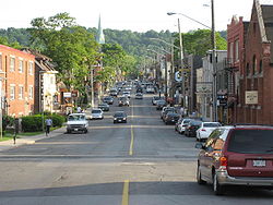
Many of the street names in Hamilton have changed over the years. James Street south of King was called Jarvis, Jackson Street was Maiden Lane, John Street was Mountain Street, Main Street east of James was Brougham Street, Hunter Street east of James was called Peel Street, Charlton Avenue West was Anderson Street, Charlton Avenue was Hannah Street, Park Street was Bond Street, Bay Street South was Bowry Street, Cannon Street was known as Henry Street, Barton Street West was Concession and Upper James Street on the mountain was known as Caledonia Road.
The following is a list of streets found in Hamilton, Ontario
Hamilton, Ontario
Hamilton is a port city in the Canadian province of Ontario. Conceived by George Hamilton when he purchased the Durand farm shortly after the War of 1812, Hamilton has become the centre of a densely populated and industrialized region at the west end of Lake Ontario known as the Golden Horseshoe...
:
Lower City (below Escarpment)
- 50 Road
- Aberdeen AvenueAberdeen Avenue (Hamilton, Ontario)Aberdeen Avenue is a Lower City arterial road in Hamilton, Ontario, Canada. It starts off just West of Longwood Road South and East of Highway 403 as a two-way thoroughfare up to Queen Street South where it then switches over to a one-way collector road to Bay Street South and then to another...
, named after Lord Aberdeen (John Hamilton-Gordon, 1st Marquess of Aberdeen and Temair)John Hamilton-Gordon, 1st Marquess of Aberdeen and TemairJohn Campbell Hamilton-Gordon, 1st Marquess of Aberdeen and Temair, KT, GCMG, GCVO, PC , known as The Earl of Aberdeen from 1870 to 1916, was a Scottish politician...
and Lady Aberdeen (Ishbel Hamilton-Gordon, Marchioness of Aberdeen and Temair)Ishbel Hamilton-Gordon, Marchioness of Aberdeen and TemairIshbel Maria Hamilton-Gordon, Marchioness of Aberdeen and Temair, GBE was a Scottish author, philanthropist and an advocate of woman's interests.-Family:...
who both lived in Hamilton on Bay Street South (1890–1898) with their four children. They presided over the opening of the Hamilton Public Library on September 16, 1890. Lord Aberdeen was appointed Governor General of CanadaGovernor General of CanadaThe Governor General of Canada is the federal viceregal representative of the Canadian monarch, Queen Elizabeth II...
in 1893. - Augusta StreetAugusta Street (Hamilton, Ontario)Augusta Street is a Lower City collector road in Hamilton, Ontario, Canada. A two-way collector road that starts off on James Street South and ends 4-blocks East at Shamrock Park just past Walnut Street South.-History:thumb|Augusta Street, landmark...
, originally, between Catharine StreetCatharine Street (Hamilton, Ontario)Catharine Street, is a Lower City collector road in Hamilton, Ontario, Canada. It starts off at Charlton Avenue East at Woolverton Park in the Corktown neighbourhood as a one-way street , tunnels underneath the Hunter Street Railway bridge and stretches up to Barton Street East where it then turns...
and Ferguson AvenueFerguson Avenue (Hamilton, Ontario)Ferguson Avenue, is a Lower City collector road in Hamilton, Ontario, Canada. Is a two-way street throughout that starts off at the base of the Mountain on Foster Street. It's interrupted 3-blocks north at Corktown Park where Canadian Pacific Railway lines passes through it...
was known as O'Reilly Street. - Barton StreetBarton Street (Hamilton, Ontario)Barton Street is an arterial road in the Lower City of Hamilton, Ontario, Canada. It's also the longest street in the city. It starts off at the Western end of town at Locke Street North and is a two-way street that stretches eastward through a number of different and varied communities in the...
, In the early days Hamilton was known as Barton township, named after a township in Lincoln County, England. Barton Street is all that remains of the township. - Bay StreetBay Street (Hamilton)Bay Street is a Lower City arterial road in Hamilton, Ontario, Canada. It starts at Inglewood Drive, just South of Aberdeen Avenue, as a collector road with only two lanes, then eventually becomes a six lane thoroughfare at its peak. Bay Street also passes through Downtown Hamilton, where many...
, derives its name from its proximity to Hamilton Harbour, which was once Burlington Bay. - Beach BoulevardBeach Boulevard (Hamilton, Ontario)Beach Boulevard is a Lower city street in Hamilton, Ontario, Canada, north of the Hamilton Harbour on a thin piece of land that crosses over Lake Ontario and stretches from where Woodward Avenue becomes Eastport Drive in the east to near the Lift Bridge in the west at Eastport Drive . It runs...
, road that runs parallel with the Burlington Bay Skyway Bridge. - Burlington Street, original name was Industrial Road. It derives its name from its proximity to Hamilton Harbour, which used to be called Burlington BayBurlington BayBurlington Bay, known more commonly as Hamilton Harbour, lies on the western tip of Lake Ontario, bounded on the northwest by the City of Burlington, on the south by the City of Hamilton, and on the east by Hamilton Beach and Burlington Beach...
. - Cannon StreetCannon Street (Hamilton, Ontario)Cannon Street, is a Lower City collector road in Hamilton, Ontario, Canada. It starts off at Queen Street North as a one-way street up to Sherman Avenue North where it then switches over to a two-way street the rest of the way Eastward and ends just past Kenilworth Avenue North on Barons Avenue...
, was originally called Henry Street. The section between BayBay Street (Hamilton)Bay Street is a Lower City arterial road in Hamilton, Ontario, Canada. It starts at Inglewood Drive, just South of Aberdeen Avenue, as a collector road with only two lanes, then eventually becomes a six lane thoroughfare at its peak. Bay Street also passes through Downtown Hamilton, where many...
and James StreetsJames Street (Hamilton, Ontario)James Street is a Lower City arterial road in Hamilton, Ontario, Canada. It starts off at the base of the Niagara Escarpment from James Mountain Road, a mountain-access road in the city, originally was a one-way street going south throughout but now has sections of it that are two-way...
was called Miles Street. The origins of the Cannon street name remains a mystery for local historians. - Caroline Street named after one of Peter HessPeter HessPeter Hess was a farmer and landowner. Peter Street and Hess Street in the city of Hamilton, Ontario are named after him as well as Caroline Street after one of his daughters....
's daughters. - Catharine StreetCatharine Street (Hamilton, Ontario)Catharine Street, is a Lower City collector road in Hamilton, Ontario, Canada. It starts off at Charlton Avenue East at Woolverton Park in the Corktown neighbourhood as a one-way street , tunnels underneath the Hunter Street Railway bridge and stretches up to Barton Street East where it then turns...
, named after Nathaniel HughsonNathaniel HughsonNathaniel Hughson, born: 16 July 1755 at New York. died: 1 November 1837 at Hamilton, Ontario. Farmer and hotel owner, Loyalist who moved to Canada following the American Revolution, one of the city founders of Hamilton, Ontario. Married to Rebecca Land...
's daughter. (Hughson was one of the city founders of Hamilton). Other streets in the city were named after him and his family members. Hughson, Rebecca (wife) and James (son). - Centennial ParkwayCentennial Parkway (Hamilton, Ontario)Centennial Parkway, is a Lower City arterial road in Hamilton, Ontario, Canada. It is best known as the western terminus of former King's Highway 20, now maintained by the City of Hamilton...
- Charlton AvenueCharlton Avenue (Hamilton, Ontario)Charlton Avenue, is a Lower City collector road in Hamilton, Ontario, Canada. This collector road starts of just West of Dundurn Street as a one-way street up to James Street South where it then switches over to a two-way street the rest of the way eastward and ends at Wentworth Street South right...
, named after Benjamin Ernest CharltonBenjamin Ernest CharltonBenjamin Ernest Charlton was the mayor of Hamilton, Ontario from 1867 and 1873-1874...
, (1835–1901), teacher, manufacturer, politician and mayor of Hamilton. Originally Charlton Street was named Hannah Street. - Cochrane RoadCochrane Road (Hamilton, Ontario)Cochrane Road is a two-way Lower City collector road in Hamilton, Ontario, Canada. It starts off at the Queenston Traffic Circle and travels South between the Bartonville and Glenview neighbourhoods right through to the Rosedale neighbourhood where it ends at Greenhill Avenue in front of Rosedale...
, road that leads to King's Forest Park from the Queenston Traffic Circle. - Cootes DriveCootes DriveCootes Drive, formerly known as the Dundas Diversion, is a city street in Hamilton, Ontario. The route connects York Boulevard and King Street in Dundas with Highway 2 and Highway 8 to the southeast, and is considered the first divided highway in Canada....
- Dundurn StreetDundurn Street (Hamilton, Ontario)Dundurn Street, is a Lower City arterial road in Hamilton, Ontario, Canada. It is a two-way street that starts off at Mountain Face Park, Niagara Escarpment in front of the Bruce Trail as a collector road, right behind Hillcrest Avenue and then turns into a four lane thoroughfare from Aberdeen...
, originated with Sir Allan MacNabAllan MacNabSir Allan Napier MacNab, 1st Baronet was a Canadian political leader and Premier of the Province of Canada before Canadian Confederation .-Biography:...
who named his home Dundurn CastleDundurn CastleDundurn Castle is a historic neoclassical mansion on York Boulevard in Hamilton, Ontario, Canada. The house took three years and $175,000.00 to build, and was completed in 1835....
and its landscaped grounds Dundurn Park. Originally Dundurn Street, South of King Street West was known as Garth Street up to 1913. Dundurn is a GaelicGoidelic languagesThe Goidelic languages or Gaelic languages are one of the two branches of the Insular Celtic languages, the other consisting of the Brythonic languages. Goidelic languages historically formed a dialect continuum stretching from the south of Ireland through the Isle of Man to the north of Scotland...
word meaning "the fort on the water." - Ferguson AvenueFerguson Avenue (Hamilton, Ontario)Ferguson Avenue, is a Lower City collector road in Hamilton, Ontario, Canada. Is a two-way street throughout that starts off at the base of the Mountain on Foster Street. It's interrupted 3-blocks north at Corktown Park where Canadian Pacific Railway lines passes through it...
, site of Ferguson Station (historic site)- defunct train station. Summertime Mustard Festival held here. Ferguson Avenue south of Main Street use to be called, Cherry Street. - Fruitland Road
- Gage AvenueGage Avenue (Hamilton, Ontario)thumb|right|350px|Gage Park WaterfountainGage Avenue, is a Lower City arterial road in Hamilton, Ontario, Canada. It starts off at Lawrence Road at the base of the Niagara Escarpment at the south end of Gage Park...
, and Upper Gage Street are named after James GageJames GageJames Gage was born in Greenbush, New York. Lumber merchant, miller. His father, a private in the New York militia, was killed fighting the British in 1777. His mother moved with the family to Canada in 1790 and they began farming in the Stoney Creek area. James gradually took responsibility...
, a lumber merchant and his uncle William Gage, a farmer. Together James and William had a farm that was the site of the Battle of Stoney CreekBattle of Stoney CreekThe Battle of Stoney Creek was fought on 6 June 1813 during the War of 1812 near present day Stoney Creek, Ontario. British units made a night attack on an American encampment...
during the War of 1812War of 1812The War of 1812 was a military conflict fought between the forces of the United States of America and those of the British Empire. The Americans declared war in 1812 for several reasons, including trade restrictions because of Britain's ongoing war with France, impressment of American merchant...
. The wounded were treated inside their home and they were both awarded compensation for it by the government. - Governor's Road,
- Gray Road
- Green Road
- Herkimer Street, Herkimer Street was named after Mary Herkimer, the daughter of United Empire Loyalist Johan Host Herkimer. Mary Herkimer married Robert Hamilton of Queenston and thereby became the stepmother of John George Hamilton, the founder of the city of Hamilton, Ontario. When George Hamilton was building the city that bears his name in the early 1800s, he named one of the new streets Herkimer Street in her honor.[1]
- Hess StreetHess Street (Hamilton, Ontario)Hess Street, is a Lower City collector road in Hamilton, Ontario, Canada. It starts off at the base of the Niagara Escarpment right before Aberdeen Avenue, and is a one-way street going north past the Durand and Central neighbourhoods. Between Main and King Street West is where you will find Hess...
, named after Peter HessPeter Hess (Hamilton, Ontario)Peter Hess was a farmer and landowner. Peter Street and Hess Street in the city of Hamilton, Ontario are named after him as well as Caroline Street after one of his daughters....
, (1779–1855), farmer, landowner. Peter Street in Hamilton also named after him as well as Caroline Street named after one of his daughters. also the site of Hess Village. - Hughson StreetHughson Street (Hamilton, Ontario)Hughson Street is a Lower City collector road in Hamilton, Ontario, Canada. It starts at Charlton Avenue East at St. Joseph's hospital and runs north to Haymarket Street in the downtown where it's cut off by the Hamilton GO Transit station. Up to this point it is a two-way street...
, named after Nathaniel HughsonNathaniel HughsonNathaniel Hughson, born: 16 July 1755 at New York. died: 1 November 1837 at Hamilton, Ontario. Farmer and hotel owner, Loyalist who moved to Canada following the American Revolution, one of the city founders of Hamilton, Ontario. Married to Rebecca Land...
, (1755–1837), Farmer & hotel owner, Loyalist who moved to Canada following the American RevolutionAmerican RevolutionThe American Revolution was the political upheaval during the last half of the 18th century in which thirteen colonies in North America joined together to break free from the British Empire, combining to become the United States of America...
, one of the city founders. Other Streets in the city were named after his family members: James, Rebecca and Catharine. - Hunter StreetHunter Street (Hamilton, Ontario)Hunter Street is a Lower City collector road in Hamilton, Ontario, Canada. It is a one-way street that starts West of Locke Street at Hill Street Park and ends two blocks East of Victoria Avenue at Emerald Street...
, named after Peter Hunter HamiltonPeter Hunter HamiltonPeter Hunter Hamilton, born: 1800 at Queenston Heights, Upper Canada. died: 1857 at Hamilton, Ontario. Buried in Hamilton Cemetery. Landowner and businessman + half brother of city founder George Hamilton...
, (1800–1857), landowner and businessman + half brother of city founder George HamiltonGeorge Hamilton (politician)George Hamilton was a Canadian merchant and politician, who founded the city of Hamilton, Ontario.Hamiliton was born on October 1788 in Queenston Heights...
. Originally, sections of Hunter Street were called William Street after King William IV and Peel Street after the British PM, Sir Robert Peel. - Jackson StreetJackson Street (Hamilton, Ontario)Jackson Street, is a Lower City collector road in Hamilton, Ontario, Canada. It starts off West of Locke Street South at Jackson Playground as a one-way street up to Queen Street South where it then switches over to a two-way street and is interrupted at Bay Street South the site of the Hamilton...
, named after Edward JacksonEdward Jackson (manufacturer)Edward Jackson, born: 20 April 1799 at Redding, Connecticut. died: 14 July 1872 at Hamilton, Ontario. Tinware manufacturer. Edward came to Canada with his wife in 1826 and settled at Niagara , where he opened a tinware business. Two years later moved to Ancaster, Ontario and opened up a similar firm...
, (1799–1872), tinware manufacturer. Originally Jackson Street was called Tyburn Street and later Maiden Lane. It is now named after Edward Jackson. - James StreetJames Street (Hamilton, Ontario)James Street is a Lower City arterial road in Hamilton, Ontario, Canada. It starts off at the base of the Niagara Escarpment from James Mountain Road, a mountain-access road in the city, originally was a one-way street going south throughout but now has sections of it that are two-way...
, named after one of Nathaniel HughsonNathaniel HughsonNathaniel Hughson, born: 16 July 1755 at New York. died: 1 November 1837 at Hamilton, Ontario. Farmer and hotel owner, Loyalist who moved to Canada following the American Revolution, one of the city founders of Hamilton, Ontario. Married to Rebecca Land...
's sons. Hughson was one of the City founders of Hamilton along with George HamiltonGeorge Hamilton (politician)George Hamilton was a Canadian merchant and politician, who founded the city of Hamilton, Ontario.Hamiliton was born on October 1788 in Queenston Heights...
and James DurandJames DurandJames Durand was a businessman and political figure in Upper Canada.He was born in Abergavenny, Wales in 1775 and came to Upper Canada in 1802 to deal with delinquent accounts on behalf of a group of London merchants. Having seized the Bridgewater Works at Chippawa, Durand purchased the operation...
. Originally, James Street was called Lake Road because it was the road that led to Lake Ontario to the north. Then it was renamed to Jarvis Street after city founder George HamiltonGeorge Hamilton (politician)George Hamilton was a Canadian merchant and politician, who founded the city of Hamilton, Ontario.Hamiliton was born on October 1788 in Queenston Heights...
's wife (Maria Jarvis) and then finally changed to its present-day James. - John StreetJohn Street (Hamilton, Ontario)John Street, is a Lower City arterial road in Hamilton, Ontario, Canada. Originally it was known as Mountain Road or Ancaster Road. It starts off at the base of Arkledun Avenue, a Mountain-access road in the city, just east of St.Joseph's Hospital where it's a one-way street going north and tunnels...
, originally known as Mountain Road. - Kenilworth AvenueKenilworth Avenue (Hamilton, Ontario)Kenilworth Avenue, is a Lower City arterial road in Hamilton, Ontario, Canada. It starts off at the Kenilworth Traffic Circle and Kenilworth Access, a mountain-access road at the base of the Niagara Escarpment and is a two-way street throughout stretching northward through the city's North End...
- King Street (Hamilton), follows the path of an old Indian Trail and was named after King George III.
- King Street (Dundas)King Street (Dundas, Hamilton, Ontario)King Street starts off as a collector road in the east-end of town in Dundas, Hamilton, Ontario, Canada beside Cootes Paradise and the Desjardins Canal at Olympic Drive and switches to an arterial road at York Street and cuts through the town of Dundas where it ends in the west-end by the CN...
, - King William StreetKing William Street (Hamilton, Ontario)400px|thumb|Theatre AquariusKing William Street is a Lower City collector road in Hamilton, Ontario, Canada. It starts off at the western-end at James Street North and is a one-way street until Mary Street, where it becomes a two-way street that ends at Wentworth Street North.-History:In 1922,...
- Lake Avenue, the hub of early Stoney CreekStoney Creek, OntarioStoney Creek is a community in Ontario, Canada.Note: This article will only deal with matters up to its amalgamation with Hamilton.-Geography and population:...
was the intersection of Lake Avenue and King Street. - http://www.lockestreet.com/ Locke Street, antique shops and cafes. Origins of street name as early as 1840 when it was spelled as L-o-c-k and by 1870 the spelling was standardized to "Locke". North of King Street West was known as Railway Street because it ran to the Great Western RailwayGreat Western RailwayThe Great Western Railway was a British railway company that linked London with the south-west and west of England and most of Wales. It was founded in 1833, received its enabling Act of Parliament in 1835 and ran its first trains in 1838...
yards. - MacNab StreetMacNab Street (Hamilton, Ontario)MacNab Street, is a Lower City collector road in Hamilton, Ontario, Canada. It starts in the Durand neighbourhood on Markland Street, as a one-way street going north to Bold Street, where it becomes two-way for one block until Hurst Place where it's cut off by a wall for the Hunter Street railway...
, named after Allan McNab, (1798–1862), Sir. Allan Napier McNab soldier, lawyer, businessman, knight and former Prime Minister of Upper Canada. - Main StreetMain Street (Hamilton, Ontario)Main Street, is a Lower City arterial road in Hamilton, Ontario, Canada. It starts east of Wilson Street in Ancaster at White Chapel Cemetery as a two-way street and switches over to a one-way street at Paradise Road South, in Westdale, where it continues up to the Delta where it once again...
, originally called Court Street, after the first courthouse that stood on it. It is now called Main Street because it formed the "main" concession line of Barton Township. - Nash RoadNash Road (Hamilton, Ontario)Nash Road is a Lower City street in Hamilton, Ontario, Canada. It starts off at King Street East in front of the Father Sean O'Sullivan Memorial Park and is a two-way collector road throughout that extends north to the Nashdale neighbourhood past Bancroft Street where it then hangs a right and...
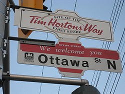
- Ottawa StreetOttawa Street (Hamilton, Ontario)Ottawa street, is a Lower City arterial road in Hamilton, Ontario, Canada. It starts off at Lawrence Road at the base of the Niagara Escarpment and is a two-way street throughout cutting through the Delta and Crown Point neighbourhoods and the City's North End industrial neighbourhood...
B.I.A, also known as Hamilton's "Textile District." - Parkdale AvenueParkdale Avenue (Hamilton, Ontario)Parkdale Avenue, is a Lower City arterial road in Hamilton, Ontario, Canada. It starts off just South of Lawrence Road at Hixon Road and is a two-way street throughout, stretching northward through the city's North End industrial neighbourhood and ends just north of the Burlington Street East...
- Quigley Road
- Queen StreetQueen Street (Hamilton, Ontario)Queen Street, is a Lower City arterial road in Hamilton, Ontario, Canada. It starts off at Beckett Drive, a mountain-access road in the city and is a two-way street up to Herkimer Street and a one-way street the rest of the way north up to the Canadian National Railway Yard where the road turns...
, was named after Queen Caroline of BrunswickCaroline of BrunswickCaroline of Brunswick-Wolfenbüttel was the Queen consort of King George IV of the United Kingdom from 29 January 1820 until her death...
, wife of King George IV. - Queenston RoadQueenston Road (Hamilton, Ontario)Queenston Road is a two-way Lower City arterial road in Hamilton, Ontario, Canada. Also known as Highway 8. It starts off at the Queenston Traffic Circle and travels eastward over the Red Hill Valley Parkway and into Stoney Creek past the Fruitland and Winona communities and into Niagara Region as...
, the original "Hamilton & Queenston Provincial Highway", no. 8. - Sherman AvenueSherman Avenue (Hamilton, Ontario)Sherman Avenue, is a Lower City collector road in Hamilton, Ontario, Canada. It starts off at the base of the Niagara Escarpment just south of Cumberland Avenue and is a one-way street northbound that cuts through the city's North End industrial neighbourhood and ends at Ship Street, the site of...
, originally called Shearman Avenue which was named after the first land assessor of the district, nothing more is known of Shearman who remains a man of mystery in Hamilton's history books. Later the name was changed from Shearman to Sherman Avenue in honour of brothers Clifton Sherman, (1872–1955) and Frank Sherman, (1887–1967), who both founded Dominion Foundries and Steel (later called DofascoDofascoDofasco is a steel company based in Hamilton, Ontario, Canada, which is also home to longtime Canadian rival Stelco. Dofasco is currently a standalone subsidiary of ArcelorMittal, the world's largest steel producer. Previously ordered by the U.S...
) in 1912, creating a giant that would bring prosperity and identity to the city. - Victoria AvenueVictoria Avenue (Hamilton, Ontario)Victoria Avenue, is a Lower City arterial road in Hamilton, Ontario, Canada. It starts off as a ramp and part of a Mountain-access road, the Claremont Access, on Hunter Street East in the Stinson neighbourhood...
, named after Queen Victoria. - Wentworth StreetWentworth Street (Hamilton, Ontario)Wentworth Street, is a Lower City arterial road in Hamilton, Ontario, Canada. It starts off at the base of the Niagara Escarpment on Charlton Avenue East just before the CP lines as a two-way street for 2-blocks up past Cumberland Avenue up to Rutherford Avenue where it then switches over to a...
, named after Sir John WentworthJohn Wentworth (governor)Sir John Wentworth, 1st Baronet was the British colonial governor of New Hampshire at the time of the American Revolution. He was later also Lieutenant-Governor of Nova Scotia.-Early life:...
, lieutenant-governor of Nova ScotiaNova ScotiaNova Scotia is one of Canada's three Maritime provinces and is the most populous province in Atlantic Canada. The name of the province is Latin for "New Scotland," but "Nova Scotia" is the recognized, English-language name of the province. The provincial capital is Halifax. Nova Scotia is the...
, from 1792 to 1808. - Wellington StreetWellington Street (Hamilton, Ontario)Wellington Street, is a Lower City arterial road in Hamilton, Ontario, Canada. It starts off at Charlton Avenue East as a two-way street for only one block where it's then blocked off by the Corktown Park and a couple of Canadian National Railway lines that cut through it...
, originally Wellington Street was called Lovers' Lane. - Wilson Street (Hamilton)Wilson Street (Hamilton, Ontario)Wilson Street is a Lower City collector road in Hamilton, Ontario, Canada. It starts off at James Street North and works its way East and ends at Sherman Avenue North...
, Wilson Street between James StreetJames Street (Hamilton, Ontario)James Street is a Lower City arterial road in Hamilton, Ontario, Canada. It starts off at the base of the Niagara Escarpment from James Mountain Road, a mountain-access road in the city, originally was a one-way street going south throughout but now has sections of it that are two-way...
and Mary Street was originally called Gore Street after the District of Gore. Wilson Street was named after Hugh B. Wilson, a local landowner who opened a survey on the street. - Woodward AvenueWoodward Avenue (Hamilton, Ontario)Woodward Avenue is an arterial road in Hamilton, Ontario, Canada. It starts in the north-end as Eastport Drive and the road changes its name south of Burlington Street beside the Museum of Steam & Technology to Woodward Avenue and extends southward and ends at Melvin Avenue...
, - York BoulevardYork Boulevard (Hamilton, Ontario)York Boulevard is a Lower City arterial road in Hamilton, Ontario, Canada. Formerly known as Highway 2 and Highway 6,starts off in Burlington, Ontario at Plains Road West as a two-way arterial road that wraps around and over the Hamilton Harbour and enters the city of Hamilton in the West-end past...
, was part of the military road that connected the chain stations lying between Kingston and the Niagara River, this road was the main route to York (TorontoTorontoToronto is the provincial capital of Ontario and the largest city in Canada. It is located in Southern Ontario on the northwestern shore of Lake Ontario. A relatively modern city, Toronto's history dates back to the late-18th century, when its land was first purchased by the British monarchy from...
). As a result, it became known as York Street. In 1976, the road was closed for construction, widened and renamed York Boulevard November 29, 1976.
Mountain (Escarpment)
- Airport Road
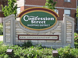
- http://www.concessionstreet.com/ Concession StreetConcession Street (Hamilton, Ontario)Concession Street is an Upper City arterial road in Hamilton, Ontario, Canada. It starts at Belvidere Avenue, just West of Sam Lawrence Park, and extends eastward past Mountain Drive Park on Upper Gage Avenue and ends shortly thereafter at East 43rd Street.Note: East of East 43rd Street the road...
, (oldest settlement area on the mountain, once an African American neighbourhood settled by slaves escaping the U.S. via the underground railroadUnderground RailroadThe Underground Railroad was an informal network of secret routes and safe houses used by 19th-century black slaves in the United States to escape to free states and Canada with the aid of abolitionists and allies who were sympathetic to their cause. The term is also applied to the abolitionists,...
Underground RailroadUnderground RailroadThe Underground Railroad was an informal network of secret routes and safe houses used by 19th-century black slaves in the United States to escape to free states and Canada with the aid of abolitionists and allies who were sympathetic to their cause. The term is also applied to the abolitionists,...
). Originally known as Stone Road and changed to Concession Street in 1909. Originally was a separate community from the Lower city HamiltonHamilton, OntarioHamilton is a port city in the Canadian province of Ontario. Conceived by George Hamilton when he purchased the Durand farm shortly after the War of 1812, Hamilton has become the centre of a densely populated and industrialized region at the west end of Lake Ontario known as the Golden Horseshoe...
and known as "Mount Hamilton" but by 1891, properties north of Concession Street were annexed by the city and were serviced with water, sewers and sidewalks. Note: Aberdeen Avenue in the Lower City was originally known as Concession Street. - Dartnall Road
- Dickenson Road, named after John Dickenson, politician and one of the "Five John's" of the Cataract Power Company who first brought electricity from DeCew Falls to Hamilton. Although was one of the country's electrical pioneers, he never had electric power in his home. John's great grandson Herb DickensonHerb DickensonJohn Herbert Dickenson is a retired Canadian ice hockey left winger. He played in the NHL for the New York Rangers.-External links:...
played for the New York RangersNew York RangersThe New York Rangers are a professional ice hockey team based in the borough of Manhattan in New York, New York, USA. They are members of the Atlantic Division of the Eastern Conference of the National Hockey League . Playing their home games at Madison Square Garden, the Rangers are one of the...
in the NHL. - Fennell AvenueFennell Avenue (Hamilton, Ontario)Fennell Avenue, is an Upper City arterial road in Hamilton, Ontario, Canada. It starts of just West Garth Street on the West mountain and is a two-way street throughout that extends eastward and ends at Mountain Brow Boulevard, a road that wraps around the edge of the Niagara Escarpment on...
, named after Joseph FennellJoseph FennellJoseph Fennell, born: 16 March, 1835 at Cobourg, Upper Canada. died: February, 1919. Anglican priest. Graduated from Victoria College, Cobourg, and from Trinity College, Toronto. Excellent horseman and involved himself with the farm activities of his parishioners. He knew crops and livestock....
, (1835–1919), Anglican priest. - Fiddlers Green Road, named after a legend that talks about a group of fiddlers that would gather nearby Fiddler's Green Inn with their violins for much music and dancing.
- Garner Road, named after William B. Garner (blacksmith) who operated a blacksmith shop on the intersection with Southcote Road.
- Garth StreetGarth Street (Hamilton, Ontario)Garth Street is an Upper City arterial road in Hamilton, Ontario, Canada. It starts off at Beckett Drive, a mountain-access road in the north, and extends southward where it ends at Twenty Road just east of the Glancaster Golf and Country Club...
- Glancaster Road
- Golf Links Road
- Greenhill Avenue
- Highland Park
- Limeridge RoadLimeridge Road (Hamilton, Ontario)Limeridge Road is a two-way Upper City collector road in Hamilton, Ontario, Canada. It starts off just West of Garth Street/William McCulloch Park as Limeridge Court and cuts across the Hamilton mountain eastward running parallel with the Lincoln M...
, named after a limestone ridge that can be seen today in the rock cuts running parallel to the Lincoln M. Alexander ParkwayLincoln M. Alexander ParkwayThe Lincoln Alexander Parkway, officially nicknamed "The Linc", is a municipal expressway in the Canadian city of Hamilton, Ontario. Located on the Hamilton mountain, atop the Niagara Escarpment...
. - Mohawk RoadMohawk Road (Hamilton, Ontario)Mohawk Road, is an Upper City arterial road in Hamilton, Ontario, Canada. It is a two-way street throughout that starts just West of Highway 403 & Meadowlands and travels eastward linking up with the Lincoln M. Alexander Parkway. Mohawk Road east of Highway 403 resumes again in front of Iroquoia...
, the road follows the route of an ancient Indian TrailIndian TrailIndian Trail can refer to:*A part of or the whole of the Great Trail created by Native Americans*Indian Trail, North Carolina*A junior high in Olathe, Kansas -- Indian Trail Junior High...
. Indians walked this path from upper New York State. - Mount Albion Road
- Mountain Brow Boulevard
- Mud Street, the name originates from the 18th century and is descriptive of the road when the horse and buggy reigned.
- Nebo RoadNebo Road (Hamilton, Ontario)Nebo Road is an Upper City road in Hamilton, Ontario, Canada. It starts off at Stone Church Road East and extends southward where it ends at Chippewa Road East, just north of Lake Niapenco at the Binbrook Conservation Area....
- Ridge Road
- Rymal Road, named after William RymalWilliam RymalWilliam Rymal, born: November 19, 1759 at Upper Bethel Township, Northampton County, Pennsylvania. died: May 25, 1852 in Hamilton, Ontario, buried at Barton Union Cemetery. Farmer and one of earliest settlers on the Hamilton, Ontario mountain....
, (1759–1852), farmer and one of earliest settlers on the Hamilton mountain. - Sanatorium Road,
- Scenic Drive,
- Stone Church RoadStone Church Road (Hamilton, Ontario)Stone Church Road, is a two-way Upper City east-west arterial road in Hamilton, Ontario, Canada. It starts at Golf Links Road, just east of Meadowlands, and goes across the Escarpment and ends at Upper Mount Albion Road....
, named after the Barton Stone Church on the corner of Upper James Street. - Trinity Church Road
- Twenty Road, takes its name from Twenty Mile Creek in the northwest part of Glanbrook.
- Upper Centennial ParkwayUpper Centennial Parkway (Hamilton, Ontario)Upper Centennial Parkway is a mountain-access road in Hamilton, Ontario, Canada. Also known as Hamilton Highway 20, the road starts off at Centennial Parkway in the Lower City beside Battlefield Park and extends south up the Niagara Escarpment and southward across the mountain where it ends at...
- Upper Gage AvenueUpper Gage Avenue (Hamilton, Ontario)Upper Gage Avenue is an Upper City arterial road in Hamilton, Ontario, Canada. It starts off at Concession Street in front of Mountain Drive Park and works its way southward and ends just past Rymal Road beside Broughton West Park 2...
, Upper Gage Avenue and Gage AvenueGage Avenue (Hamilton, Ontario)thumb|right|350px|Gage Park WaterfountainGage Avenue, is a Lower City arterial road in Hamilton, Ontario, Canada. It starts off at Lawrence Road at the base of the Niagara Escarpment at the south end of Gage Park...
are named after James GageJames GageJames Gage was born in Greenbush, New York. Lumber merchant, miller. His father, a private in the New York militia, was killed fighting the British in 1777. His mother moved with the family to Canada in 1790 and they began farming in the Stoney Creek area. James gradually took responsibility...
, a lumber merchant and his uncle William Gage, a farmer. Together James and William had a farm that was the site of the Battle of Stoney CreekBattle of Stoney CreekThe Battle of Stoney Creek was fought on 6 June 1813 during the War of 1812 near present day Stoney Creek, Ontario. British units made a night attack on an American encampment...
during the War of 1812War of 1812The War of 1812 was a military conflict fought between the forces of the United States of America and those of the British Empire. The Americans declared war in 1812 for several reasons, including trade restrictions because of Britain's ongoing war with France, impressment of American merchant...
. The wounded were treated inside their homes and they were both awarded compensation for it by the government. - Upper James StreetUpper James Street (Hamilton, Ontario)Upper James Street, is an Upper City arterial road in Hamilton, Ontario, Canada. It starts at the Claremont Access, a mountain-access road in the north, and extends southward towards the John C. Munro Hamilton International Airport where it then changes its name to the Hamilton Port Dover Plain...
, (See James StreetJames Street (Hamilton, Ontario)James Street is a Lower City arterial road in Hamilton, Ontario, Canada. It starts off at the base of the Niagara Escarpment from James Mountain Road, a mountain-access road in the city, originally was a one-way street going south throughout but now has sections of it that are two-way...
), Originally was called the Caledonia Road because it was the road that led to Caledonia, OntarioCaledonia, OntarioCaledonia is a small riverside community and former town located on the Grand River in Haldimand County, Ontario, Canada. Haldimand County is in the western part of the Niagara Peninsula, and had a population of 43,280 in 2001. The current mayor of Haldimand County is Ken Hewitt; Caledonia is...
. - Upper Kenilworth AvenueUpper Kenilworth Avenue (Hamilton, Ontario)Upper Kenilworth Avenue is an Upper City arterial road in Hamilton, Ontario, Canada. It starts off at Fennell Avenue in the north and extends southward just past Limeridge Road where it ends north of the Lincoln M...
- Upper Paradise RoadUpper Paradise Road (Hamilton, Ontario)Upper Paradise Road is an Upper City collector road in Hamilton, Ontario, Canada. It starts off just north of Scenic Drive by Cliffview Park and extends southward where it ends just south of Rymal Road beside Carpenter Park...
- Upper Ottawa StreetUpper Ottawa Street (Hamilton, Ontario)Upper Ottawa Street is an Upper City arterial road in Hamilton, Ontario, Canada. It starts off at Mountain Brow Boulevard in the north and extends southward where it ends just past Rymal Road at the South Hamilton Industrial Park...
- Upper Sherman AvenueUpper Sherman Avenue (Hamilton, Ontario)Upper Sherman Avenue is an Upper City arterial road in Hamilton, Ontario, Canada. It starts off north of Concession Street at Mountain Brow Avenue and extends southward where it ends at Rymal Road. It is a two-way street throughout.-History:...
(See Sherman AvenueSherman Avenue (Hamilton, Ontario)Sherman Avenue, is a Lower City collector road in Hamilton, Ontario, Canada. It starts off at the base of the Niagara Escarpment just south of Cumberland Avenue and is a one-way street northbound that cuts through the city's North End industrial neighbourhood and ends at Ship Street, the site of...
) - Upper Wentworth StreetUpper Wentworth Street (Hamilton, Ontario)Upper Wentworth Street is an Upper City arterial road in Hamilton, Ontario, Canada. It starts off at Concession Street in the north and extends southward past Rymal Road. It is a two-way street throughout.-History:...
(See Wentworth StreetWentworth Street (Hamilton, Ontario)Wentworth Street, is a Lower City arterial road in Hamilton, Ontario, Canada. It starts off at the base of the Niagara Escarpment on Charlton Avenue East just before the CP lines as a two-way street for 2-blocks up past Cumberland Avenue up to Rutherford Avenue where it then switches over to a...
) - Upper Wellington StreetUpper Wellington Street (Hamilton, Ontario)Upper Wellington Street is an Upper City arterial road in Hamilton, Ontario, Canada. It starts at the Jolley Cut, a mountain-access road to the north, beside Sam Lawrence Park and extends southward past Rymal Road where it ends at the Mount Hamilton Cemetery...
(See Wellington StreetWellington Street (Hamilton, Ontario)Wellington Street, is a Lower City arterial road in Hamilton, Ontario, Canada. It starts off at Charlton Avenue East as a two-way street for only one block where it's then blocked off by the Corktown Park and a couple of Canadian National Railway lines that cut through it...
) - West 5th StreetWest 5th Street (Hamilton, Ontario)West 5th Street is an Upper City arterial road in Hamilton, Ontario, Canada. It starts off in the north at James Mountain Road, a mountain-access road, and extends southward past Rymal Road where it ends just south of Christopher Drive...
- Whitechurch Road
- Wilson Street (Ancaster)