
Cootes Drive
Encyclopedia
Cootes Drive, formerly known as the Dundas Diversion, is a city street in Hamilton, Ontario
. The route connects York Boulevard and King Street in Dundas
with Highway 2
and Highway 8
to the southeast, and is considered the first divided highway in Canada
.
and Highway 8
), past McMaster University
, through Cootes Paradise
to the former town Dundas, where it feeds into King Street
.
There is a shared pedestrian and bicycle path
along its length, and GO Transit
operate two regional coach routes from their McMaster University GO Bus Terminal on the east side of Cootes Drive, at the edge of the university’s campus.
built in Canada; completed in 1936, it predates the nearby Queen Elizabeth Way
, which was still under construction at the time, with the name of ‘Middle Road’.
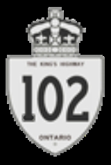
Cootes Drive is now signed as Hamilton Road 8. It was originally designated 8D (indicating that it was a diversion of Highway 8), then changed to the designation of Highway 102 in 1947, before being turned back to local authorities in 1964. The Highway 102 designation has since been reused on a different highway
near Thunder Bay
.
Hamilton, Ontario
Hamilton is a port city in the Canadian province of Ontario. Conceived by George Hamilton when he purchased the Durand farm shortly after the War of 1812, Hamilton has become the centre of a densely populated and industrialized region at the west end of Lake Ontario known as the Golden Horseshoe...
. The route connects York Boulevard and King Street in Dundas
Dundas, Ontario
Dundas is a formerly independent town and now constituent community in the city of Hamilton in Ontario, Canada. It's nickname is the Valley Town. The population has been stable for decades at about twenty thousand, largely because it has not annexed rural land from the protected Dundas Valley...
with Highway 2
Ontario Highway 2
King's Highway 2, usually referred to simply as Highway 2 is a provincially maintained highway in Ontario. Once the primary east–west route across the southern end of the province, Highway 2 became mostly redundant in the 1960s following the completion of Highway 401, which more or less...
and Highway 8
Ontario Highway 8
Provincial Highway 8 is a provincially maintained highway in the Canadian province of Ontario. Its total length is 138.5 km, though it was once much longer, running farther east from Hamilton to Niagara Falls, before the Queen Elizabeth Way replaced its role.- History :Highway 8 is one of the...
to the southeast, and is considered the first divided highway in Canada
Canada
Canada is a North American country consisting of ten provinces and three territories. Located in the northern part of the continent, it extends from the Atlantic Ocean in the east to the Pacific Ocean in the west, and northward into the Arctic Ocean...
.
Route description
Cootes Drive travels from Main Street West (former Highway 2Ontario Highway 2
King's Highway 2, usually referred to simply as Highway 2 is a provincially maintained highway in Ontario. Once the primary east–west route across the southern end of the province, Highway 2 became mostly redundant in the 1960s following the completion of Highway 401, which more or less...
and Highway 8
Ontario Highway 8
Provincial Highway 8 is a provincially maintained highway in the Canadian province of Ontario. Its total length is 138.5 km, though it was once much longer, running farther east from Hamilton to Niagara Falls, before the Queen Elizabeth Way replaced its role.- History :Highway 8 is one of the...
), past McMaster University
McMaster University
McMaster University is a public research university whose main campus is located in Hamilton, Ontario, Canada. The main campus is located on of land in the residential neighbourhood of Westdale, adjacent to Hamilton's Royal Botanical Gardens...
, through Cootes Paradise
Cootes Paradise
Cootes Paradise is the largest wetland at the western end of Lake Ontario, on the west side of Hamilton Harbour. It is bordered by the cities of Hamilton and Burlington, Ontario, Canada. It is owned and managed by the Royal Botanical Gardens , a private charitable status organization. These lands...
to the former town Dundas, where it feeds into King Street
King Street (Dundas, Hamilton, Ontario)
King Street starts off as a collector road in the east-end of town in Dundas, Hamilton, Ontario, Canada beside Cootes Paradise and the Desjardins Canal at Olympic Drive and switches to an arterial road at York Street and cuts through the town of Dundas where it ends in the west-end by the CN...
.
There is a shared pedestrian and bicycle path
Bicycle Path
Bicycle Path is a historic road in Central Suffolk County on Long Island, New York, built in the late 19th Century in order to capitalize on the bicycle craze of that period...
along its length, and GO Transit
GO Transit
GO Transit is an inter-regional public transit system in Southern Ontario, Canada. It primarily serves the Greater Toronto and Hamilton Area conurbation, with operations extending to several communities beyond the GTHA proper in the Greater Golden Horseshoe...
operate two regional coach routes from their McMaster University GO Bus Terminal on the east side of Cootes Drive, at the edge of the university’s campus.
History
The Dundas Diversion was the first divided dual-carriageway roadDual carriageway
A dual carriageway is a class of highway with two carriageways for traffic travelling in opposite directions separated by a central reservation...
built in Canada; completed in 1936, it predates the nearby Queen Elizabeth Way
Queen Elizabeth Way
The Queen Elizabeth Way, commonly abbreviated as the QEW, is a 400-Series highway in the Canadian province of Ontario. The freeway links Buffalo, New York and the Niagara Peninsula with Toronto. It begins at the Peace Bridge in Fort Erie and travels around the western shore of Lake Ontario, ending...
, which was still under construction at the time, with the name of ‘Middle Road’.
Cootes Drive is now signed as Hamilton Road 8. It was originally designated 8D (indicating that it was a diversion of Highway 8), then changed to the designation of Highway 102 in 1947, before being turned back to local authorities in 1964. The Highway 102 designation has since been reused on a different highway
Highway 102 (Ontario)
King's Highway 102, commonly referred to as Highway 102, formerly as Highway 11A and Highway 17A and historically as the Dawson Road, is a provincially maintained highway in the Canadian province of Ontario, serving as a northern bypass to the city of Thunder Bay.Both the western and eastern...
near Thunder Bay
Thunder Bay
-In Canada:Thunder Bay is the name of three places in the province of Ontario, Canada along Lake Superior:*Thunder Bay District, Ontario, a district in Northwestern Ontario*Thunder Bay, a city in Thunder Bay District*Thunder Bay, Unorganized, Ontario...
.