

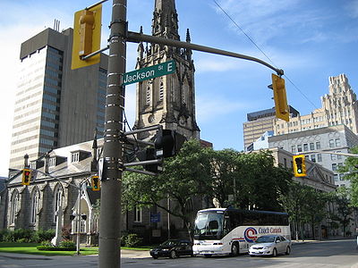
Jackson Street (Hamilton, Ontario)
Encyclopedia
Hamilton, Ontario
Hamilton is a port city in the Canadian province of Ontario. Conceived by George Hamilton when he purchased the Durand farm shortly after the War of 1812, Hamilton has become the centre of a densely populated and industrialized region at the west end of Lake Ontario known as the Golden Horseshoe...
, Canada
Canada
Canada is a North American country consisting of ten provinces and three territories. Located in the northern part of the continent, it extends from the Atlantic Ocean in the east to the Pacific Ocean in the west, and northward into the Arctic Ocean...
. It starts off West of Locke Street South
Locke Street (Hamilton, Ontario)
Locke Street, is a Lower City collector road in Hamilton, Ontario, Canada. It starts off at Aberdeen Avenue as a two-way street going through the Locke Street shopping district up to Main Street where it then becomes a one-way street until it crosses King Street and becomes two-way again going...
at Jackson Playground as a one-way street (Westbound) up to Queen Street South
Queen Street (Hamilton, Ontario)
Queen Street, is a Lower City arterial road in Hamilton, Ontario, Canada. It starts off at Beckett Drive, a mountain-access road in the city and is a two-way street up to Herkimer Street and a one-way street the rest of the way north up to the Canadian National Railway Yard where the road turns...
where it then switches over to a two-way street and is interrupted at Bay Street South
Bay Street (Hamilton)
Bay Street is a Lower City arterial road in Hamilton, Ontario, Canada. It starts at Inglewood Drive, just South of Aberdeen Avenue, as a collector road with only two lanes, then eventually becomes a six lane thoroughfare at its peak. Bay Street also passes through Downtown Hamilton, where many...
the site of the Hamilton City Hall
Hamilton City Hall
Hamilton City Hall is located in downtown Hamilton, Ontario, Canada. It is an 8-storey building , located at the corner of Main Street West and Bay Street South, across the street from the Ronald V. Joyce Centre for the Performing Arts and the Hamilton Art Gallery. It was officially opened on...
and the Canadian Football Hall of Fame
Canadian Football Hall of Fame
The Canadian Football Hall of Fame is a not-for-profit corporation, located in Hamilton, Ontario, that celebrates great achievements in Canadian football. It is an open to the public institution. It includes displays about the Canadian Football League, Canadian university football and Canadian...
(museum), resumes again East of the property on MacNab Street South
MacNab Street (Hamilton, Ontario)
MacNab Street, is a Lower City collector road in Hamilton, Ontario, Canada. It starts in the Durand neighbourhood on Markland Street, as a one-way street going north to Bold Street, where it becomes two-way for one block until Hurst Place where it's cut off by a wall for the Hunter Street railway...
and then ends at Wellington Street South
Wellington Street (Hamilton, Ontario)
Wellington Street, is a Lower City arterial road in Hamilton, Ontario, Canada. It starts off at Charlton Avenue East as a two-way street for only one block where it's then blocked off by the Corktown Park and a couple of Canadian National Railway lines that cut through it...
.
History
Jackson Street is named after Edward JacksonEdward Jackson (manufacturer)
Edward Jackson, born: 20 April 1799 at Redding, Connecticut. died: 14 July 1872 at Hamilton, Ontario. Tinware manufacturer. Edward came to Canada with his wife in 1826 and settled at Niagara , where he opened a tinware business. Two years later moved to Ancaster, Ontario and opened up a similar firm...
, (1799-1872), tinware manufacturer. Originally Jackson Street was called Tyburn Street and later Maiden Lane. It is now named after Edward Jackson.
CHCH TV 11 began broadcasting in 1954 as a CBC
Canadian Broadcasting Corporation
The Canadian Broadcasting Corporation, commonly known as CBC and officially as CBC/Radio-Canada, is a Canadian crown corporation that serves as the national public radio and television broadcaster...
affiliate from a transmitter located at 481 First Road West in Stoney Creek
Stoney Creek, Ontario
Stoney Creek is a community in Ontario, Canada.Note: This article will only deal with matters up to its amalgamation with Hamilton.-Geography and population:...
. At the time, all private stations were required to be CBC affiliates. The CHCH Television Tower
CHCH Television Tower
The CHCH Television Tower is a 357.5 metre-high guyed TV mast located at 481 First Road West in Stoney Creek, Ontario, Canada. It is the primary transmitter for television station CHCH-TV. It is also currently the third-tallest structure in Canada....
is a 357.5 metre-high guyed TV mast which is the primary transmitter for television station CHCH-TV. When it was built in 1960, the CHCH Television Tower became the tallest structure in Canada. In 1961, CHCH disaffiliated from the CBC
Canadian Broadcasting Corporation
The Canadian Broadcasting Corporation, commonly known as CBC and officially as CBC/Radio-Canada, is a Canadian crown corporation that serves as the national public radio and television broadcaster...
and became an independent TV station. In 1974, CHCH TV 11 was first in the world with the television premiere of The Godfather
The Godfather
The Godfather is a 1972 American epic crime film directed by Francis Ford Coppola, based on the 1969 novel by Mario Puzo. With a screenplay by Puzo, Coppola and an uncredited Robert Towne, the film stars Marlon Brando, Al Pacino, James Caan, Robert Duvall, Sterling Hayden, John Marley, Richard...
.
Hamilton is also home to the Canadian Football Hall of Fame
Canadian Football Hall of Fame
The Canadian Football Hall of Fame is a not-for-profit corporation, located in Hamilton, Ontario, that celebrates great achievements in Canadian football. It is an open to the public institution. It includes displays about the Canadian Football League, Canadian university football and Canadian...
museum. The museum hosts an annual induction event in a week-long celebration that includes school visits, a golf tournament, a formal induction dinner and concludes with the Hall of Fame game involving the local CFL
Canadian Football League
The Canadian Football League or CFL is a professional sports league located in Canada. The CFL is the highest level of competition in Canadian football, a form of gridiron football closely related to American football....
Hamilton Tiger-Cats
Hamilton Tiger-Cats
The Hamilton Tiger-Cats are a Canadian Football League team based in Hamilton, Ontario, founded in 1950 with the merger of the Hamilton Tigers and the Hamilton Wildcats. The Tiger-Cats play their home games at Ivor Wynne Stadium...
at Ivor Wynne Stadium.
Landmarks
- Jackson Playground
- Locke Street Shopping district (Antique shops, Art galleries, Cafes & fine dining Restaurants)
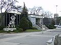
- CHCH-TVCHCH-TVCHCH-DT, channel 11, is a television station originating in Hamilton, Ontario, Canada, with transmitters located throughout Ontario. CHCH currently operates as an independent station, having previously served as a CBC Television affiliate, and more recently as the flagship station of the...
11 Studios - old Bell TelephoneBell TelephoneBell Telephone may refer to:* Bell Telephone Company, several telephone companies with similar names* Bell Telephone Building , various* The Bell Telephone Hour, a long-running radio and television concert program...
building converted to lofts. - Bay 200, residential apartment building (Hamilton's 10th-tallest building)
- Hamilton City HallHamilton City HallHamilton City Hall is located in downtown Hamilton, Ontario, Canada. It is an 8-storey building , located at the corner of Main Street West and Bay Street South, across the street from the Ronald V. Joyce Centre for the Performing Arts and the Hamilton Art Gallery. It was officially opened on...
(back end) - Canadian Football Hall of FameCanadian Football Hall of FameThe Canadian Football Hall of Fame is a not-for-profit corporation, located in Hamilton, Ontario, that celebrates great achievements in Canadian football. It is an open to the public institution. It includes displays about the Canadian Football League, Canadian university football and Canadian...
(museum) - Downtown YWCAYWCAThe YWCA USA is the United States branch of a women's membership movement that strives to create opportunities for women's growth, leadership and power in order to attain a common vision—to eliminate racism and empower women. The YWCA is a non-profit organization, the first of which was founded in...
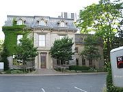
- WhitehernWhitehernWhitehern Historic House and Garden in Hamilton, Ontario, Canada, built shortly before 1850, is a Late Classical house that is now a historic house museum....
(museum) - Downtown YMCAYMCAThe Young Men's Christian Association is a worldwide organization of more than 45 million members from 125 national federations affiliated through the World Alliance of YMCAs...
- James Street South Shopping District
- Hamilton Courthouse (back-end)
- United International Laborers Union of North America building
- New Horizon Office Building (Tailgate Charlie's restaurant/ bar)
Communities
Note: Listing of neighbourhoods from West to East.- Kirkendall
- Durand
- Corktown
Parallel roads
Lower City Roads:- Burlington StreetBurlington StreetBurlington Street is a road in Hamilton, Ontario, stretching along the south shore of Hamilton Harbour in Lake Ontario. Burlington Street has four different statuses along the route. In its western terminus, it is a collector route ending at Bay Street North...
, West/East - Barton StreetBarton Street (Hamilton, Ontario)Barton Street is an arterial road in the Lower City of Hamilton, Ontario, Canada. It's also the longest street in the city. It starts off at the Western end of town at Locke Street North and is a two-way street that stretches eastward through a number of different and varied communities in the...
, West/East - Cannon StreetCannon Street (Hamilton, Ontario)Cannon Street, is a Lower City collector road in Hamilton, Ontario, Canada. It starts off at Queen Street North as a one-way street up to Sherman Avenue North where it then switches over to a two-way street the rest of the way Eastward and ends just past Kenilworth Avenue North on Barons Avenue...
, West/East - Wilson StreetWilson Street (Hamilton, Ontario)Wilson Street is a Lower City collector road in Hamilton, Ontario, Canada. It starts off at James Street North and works its way East and ends at Sherman Avenue North...
- King William StreetKing William Street (Hamilton, Ontario)400px|thumb|Theatre AquariusKing William Street is a Lower City collector road in Hamilton, Ontario, Canada. It starts off at the western-end at James Street North and is a one-way street until Mary Street, where it becomes a two-way street that ends at Wentworth Street North.-History:In 1922,...
- King Street, West/East
- Main StreetMain Street (Hamilton, Ontario)Main Street, is a Lower City arterial road in Hamilton, Ontario, Canada. It starts east of Wilson Street in Ancaster at White Chapel Cemetery as a two-way street and switches over to a one-way street at Paradise Road South, in Westdale, where it continues up to the Delta where it once again...
, West/East; - Queenston RoadQueenston Road (Hamilton, Ontario)Queenston Road is a two-way Lower City arterial road in Hamilton, Ontario, Canada. Also known as Highway 8. It starts off at the Queenston Traffic Circle and travels eastward over the Red Hill Valley Parkway and into Stoney Creek past the Fruitland and Winona communities and into Niagara Region as... - Jackson Street, West/East
- Hunter StreetHunter Street (Hamilton, Ontario)Hunter Street is a Lower City collector road in Hamilton, Ontario, Canada. It is a one-way street that starts West of Locke Street at Hill Street Park and ends two blocks East of Victoria Avenue at Emerald Street...
, West/East - Augusta StreetAugusta Street (Hamilton, Ontario)Augusta Street is a Lower City collector road in Hamilton, Ontario, Canada. A two-way collector road that starts off on James Street South and ends 4-blocks East at Shamrock Park just past Walnut Street South.-History:thumb|Augusta Street, landmark...
- Charlton AvenueCharlton Avenue (Hamilton, Ontario)Charlton Avenue, is a Lower City collector road in Hamilton, Ontario, Canada. This collector road starts of just West of Dundurn Street as a one-way street up to James Street South where it then switches over to a two-way street the rest of the way eastward and ends at Wentworth Street South right...
, West/East - Aberdeen AvenueAberdeen Avenue (Hamilton, Ontario)Aberdeen Avenue is a Lower City arterial road in Hamilton, Ontario, Canada. It starts off just West of Longwood Road South and East of Highway 403 as a two-way thoroughfare up to Queen Street South where it then switches over to a one-way collector road to Bay Street South and then to another...
Niagara Escarpment (Mountain) Roads:
- Concession StreetConcession Street (Hamilton, Ontario)Concession Street is an Upper City arterial road in Hamilton, Ontario, Canada. It starts at Belvidere Avenue, just West of Sam Lawrence Park, and extends eastward past Mountain Drive Park on Upper Gage Avenue and ends shortly thereafter at East 43rd Street.Note: East of East 43rd Street the road...
- Queensdale Avenue West/ East
- Scenic Drive - Fennell AvenueFennell Avenue (Hamilton, Ontario)Fennell Avenue, is an Upper City arterial road in Hamilton, Ontario, Canada. It starts of just West Garth Street on the West mountain and is a two-way street throughout that extends eastward and ends at Mountain Brow Boulevard, a road that wraps around the edge of the Niagara Escarpment on...
, West/East - Sanatorium Road
- Mohawk RoadMohawk Road (Hamilton, Ontario)Mohawk Road, is an Upper City arterial road in Hamilton, Ontario, Canada. It is a two-way street throughout that starts just West of Highway 403 & Meadowlands and travels eastward linking up with the Lincoln M. Alexander Parkway. Mohawk Road east of Highway 403 resumes again in front of Iroquoia...
, West/East - Limeridge RoadLimeridge Road (Hamilton, Ontario)Limeridge Road is a two-way Upper City collector road in Hamilton, Ontario, Canada. It starts off just West of Garth Street/William McCulloch Park as Limeridge Court and cuts across the Hamilton mountain eastward running parallel with the Lincoln M...
West/East - Lincoln M. Alexander ParkwayLincoln M. Alexander ParkwayThe Lincoln Alexander Parkway, officially nicknamed "The Linc", is a municipal expressway in the Canadian city of Hamilton, Ontario. Located on the Hamilton mountain, atop the Niagara Escarpment...
- Mud Street, (Hamilton City Road 11) - Stone Church RoadStone Church Road (Hamilton, Ontario)Stone Church Road, is a two-way Upper City east-west arterial road in Hamilton, Ontario, Canada. It starts at Golf Links Road, just east of Meadowlands, and goes across the Escarpment and ends at Upper Mount Albion Road....
, West/East  ; Rymal Road, West/East
- Twenty Road
Intersecting roads
Note: Listing of streets from West to East.- Locke Street, South
- Queen StreetQueen Street (Hamilton, Ontario)Queen Street, is a Lower City arterial road in Hamilton, Ontario, Canada. It starts off at Beckett Drive, a mountain-access road in the city and is a two-way street up to Herkimer Street and a one-way street the rest of the way north up to the Canadian National Railway Yard where the road turns...
, South - Hess StreetHess Street (Hamilton, Ontario)Hess Street, is a Lower City collector road in Hamilton, Ontario, Canada. It starts off at the base of the Niagara Escarpment right before Aberdeen Avenue, and is a one-way street going north past the Durand and Central neighbourhoods. Between Main and King Street West is where you will find Hess...
, South - Bay StreetBay Street (Hamilton)Bay Street is a Lower City arterial road in Hamilton, Ontario, Canada. It starts at Inglewood Drive, just South of Aberdeen Avenue, as a collector road with only two lanes, then eventually becomes a six lane thoroughfare at its peak. Bay Street also passes through Downtown Hamilton, where many...
, South - MacNab StreetMacNab Street (Hamilton, Ontario)MacNab Street, is a Lower City collector road in Hamilton, Ontario, Canada. It starts in the Durand neighbourhood on Markland Street, as a one-way street going north to Bold Street, where it becomes two-way for one block until Hurst Place where it's cut off by a wall for the Hunter Street railway...
, South - James StreetJames Street (Hamilton, Ontario)James Street is a Lower City arterial road in Hamilton, Ontario, Canada. It starts off at the base of the Niagara Escarpment from James Mountain Road, a mountain-access road in the city, originally was a one-way street going south throughout but now has sections of it that are two-way...
, South - Hughson StreetHughson Street (Hamilton, Ontario)Hughson Street is a Lower City collector road in Hamilton, Ontario, Canada. It starts at Charlton Avenue East at St. Joseph's hospital and runs north to Haymarket Street in the downtown where it's cut off by the Hamilton GO Transit station. Up to this point it is a two-way street...
, South - John StreetJohn Street (Hamilton, Ontario)John Street, is a Lower City arterial road in Hamilton, Ontario, Canada. Originally it was known as Mountain Road or Ancaster Road. It starts off at the base of Arkledun Avenue, a Mountain-access road in the city, just east of St.Joseph's Hospital where it's a one-way street going north and tunnels...
, South - Catharine StreetCatharine Street (Hamilton, Ontario)Catharine Street, is a Lower City collector road in Hamilton, Ontario, Canada. It starts off at Charlton Avenue East at Woolverton Park in the Corktown neighbourhood as a one-way street , tunnels underneath the Hunter Street Railway bridge and stretches up to Barton Street East where it then turns...
, South - Ferguson AvenueFerguson Avenue (Hamilton, Ontario)Ferguson Avenue, is a Lower City collector road in Hamilton, Ontario, Canada. Is a two-way street throughout that starts off at the base of the Mountain on Foster Street. It's interrupted 3-blocks north at Corktown Park where Canadian Pacific Railway lines passes through it...
, South - Wellington StreetWellington Street (Hamilton, Ontario)Wellington Street, is a Lower City arterial road in Hamilton, Ontario, Canada. It starts off at Charlton Avenue East as a two-way street for only one block where it's then blocked off by the Corktown Park and a couple of Canadian National Railway lines that cut through it...
, South