
Lincoln M. Alexander Parkway
Encyclopedia
The Lincoln Alexander Parkway, officially nicknamed "The Linc", is a municipal expressway in the Canadian
city of Hamilton, Ontario
. Located on the Hamilton mountain
, atop the Niagara Escarpment
. It is named after the former Progressive Conservative
MP
and first black Lieutenant Governor of Ontario
, Lincoln Alexander
, even though he has never held a driver's license of his own.
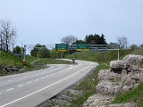
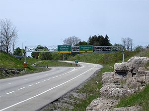
Opened on October 15, 1997, the expressway currently runs along the south of Hamilton between Highway 403 and Mud Street, and is connected to the Queen Elizabeth Way
via the Red Hill Valley Parkway
, which opened on November 17, 2007. The speed limit on the parkway is 90 km/h.
The road was once unofficially designated as part of Highway 6 up to Upper James Street; the designation has since been moved to a new alignment that passes south of Hamilton International Airport.
 The Lincoln M. Alexander Parkway begins in the west end of Hamilton at a large turbine interchange with Highway 403, which also provides access to Mohawk Road from Westbound Highway 403 and The Linc. Travelling eastbound, the expressway descends into a ditch, which it travels along approximately 200 metres (656.2 ft) south of the concession road
which it replaced.
.
Canada
Canada is a North American country consisting of ten provinces and three territories. Located in the northern part of the continent, it extends from the Atlantic Ocean in the east to the Pacific Ocean in the west, and northward into the Arctic Ocean...
city of Hamilton, Ontario
Hamilton, Ontario
Hamilton is a port city in the Canadian province of Ontario. Conceived by George Hamilton when he purchased the Durand farm shortly after the War of 1812, Hamilton has become the centre of a densely populated and industrialized region at the west end of Lake Ontario known as the Golden Horseshoe...
. Located on the Hamilton mountain
Hamilton Mountain
Hamilton Mountain is a federal electoral district in Ontario, Canada, that has been represented in the Canadian House of Commons since 1968. The riding is located in the Hamilton, Ontario region....
, atop the Niagara Escarpment
Niagara Escarpment
The Niagara Escarpment is a long escarpment, or cuesta, in the United States and Canada that runs westward from New York State, through Ontario, Michigan, Wisconsin and Illinois...
. It is named after the former Progressive Conservative
Progressive Conservative Party of Canada
The Progressive Conservative Party of Canada was a Canadian political party with a centre-right stance on economic issues and, after the 1970s, a centrist stance on social issues....
MP
Member of Parliament
A Member of Parliament is a representative of the voters to a :parliament. In many countries with bicameral parliaments, the term applies specifically to members of the lower house, as upper houses often have a different title, such as senate, and thus also have different titles for its members,...
and first black Lieutenant Governor of Ontario
Lieutenant Governor of Ontario
The Lieutenant Governor of Ontario is the viceregal representative in Ontario of the Canadian monarch, Queen Elizabeth II, who operates distinctly within the province but is also shared equally with the ten other jurisdictions of Canada and resides predominantly in her oldest realm, the United...
, Lincoln Alexander
Lincoln Alexander
-External links:* * *...
, even though he has never held a driver's license of his own.
Opened on October 15, 1997, the expressway currently runs along the south of Hamilton between Highway 403 and Mud Street, and is connected to the Queen Elizabeth Way
Queen Elizabeth Way
The Queen Elizabeth Way, commonly abbreviated as the QEW, is a 400-Series highway in the Canadian province of Ontario. The freeway links Buffalo, New York and the Niagara Peninsula with Toronto. It begins at the Peace Bridge in Fort Erie and travels around the western shore of Lake Ontario, ending...
via the Red Hill Valley Parkway
Red Hill Valley Parkway
The Red Hill Valley Parkway , referred to as the Red Hill Creek Expressway during planning is a municipal expressway in the Canadian city of Hamilton, Ontario. The route connects the Lincoln M. Alexander Parkway, Hamilton's second municipal expressway, to the Queen Elizabeth Way near Hamilton...
, which opened on November 17, 2007. The speed limit on the parkway is 90 km/h.
The road was once unofficially designated as part of Highway 6 up to Upper James Street; the designation has since been moved to a new alignment that passes south of Hamilton International Airport.
Route description
Concession road
In Upper and Lower Canada, concession roads were laid out by the colonial government through undeveloped land to define lots to be developed; the name comes from a Lower Canadian French term for a row of lots. Concession roads are straight, and follow an approximately square grid, usually oriented...
which it replaced.
Exit list
The entirety of the Lincoln M. Alexander Parkway is located within the city of HamiltonHamilton, Ontario
Hamilton is a port city in the Canadian province of Ontario. Conceived by George Hamilton when he purchased the Durand farm shortly after the War of 1812, Hamilton has become the centre of a densely populated and industrialized region at the west end of Lake Ontario known as the Golden Horseshoe...
.
| Location | km | Destinations | Notes |
|---|---|---|---|
| 0.0 | |||
| 2 | Golf Links Road / Mohawk Road Mohawk Road (Hamilton, Ontario) Mohawk Road, is an Upper City arterial road in Hamilton, Ontario, Canada. It is a two-way street throughout that starts just West of Highway 403 & Meadowlands and travels eastward linking up with the Lincoln M. Alexander Parkway. Mohawk Road east of Highway 403 resumes again in front of Iroquoia... (Hamilton Road 260) |
||
| 4 | Garth Street Garth Street (Hamilton, Ontario) Garth Street is an Upper City arterial road in Hamilton, Ontario, Canada. It starts off at Beckett Drive, a mountain-access road in the north, and extends southward where it ends at Twenty Road just east of the Glancaster Golf and Country Club... |
||
| 6 | Upper James Street Upper James Street (Hamilton, Ontario) Upper James Street, is an Upper City arterial road in Hamilton, Ontario, Canada. It starts at the Claremont Access, a mountain-access road in the north, and extends southward towards the John C. Munro Hamilton International Airport where it then changes its name to the Hamilton Port Dover Plain... |
||
| 8 | Upper Wentworth Street Upper Wentworth Street (Hamilton, Ontario) Upper Wentworth Street is an Upper City arterial road in Hamilton, Ontario, Canada. It starts off at Concession Street in the north and extends southward past Rymal Road. It is a two-way street throughout.-History:... |
||
| 10 | Upper Gage Avenue Upper Gage Avenue (Hamilton, Ontario) Upper Gage Avenue is an Upper City arterial road in Hamilton, Ontario, Canada. It starts off at Concession Street in front of Mountain Drive Park and works its way southward and ends just past Rymal Road beside Broughton West Park 2... |
||
| 12 | Dartnell Road | ||
| 13 | Mud Street |