
List of rivers of Antarctica
Encyclopedia
This is a list of rivers of Antarctica. Although they are variously named river
, creek or stream
, those listed are technically all meltwater streams.
River
A river is a natural watercourse, usually freshwater, flowing towards an ocean, a lake, a sea, or another river. In a few cases, a river simply flows into the ground or dries up completely before reaching another body of water. Small rivers may also be called by several other names, including...
, creek or stream
Stream
A stream is a body of water with a current, confined within a bed and stream banks. Depending on its locale or certain characteristics, a stream may be referred to as a branch, brook, beck, burn, creek, "crick", gill , kill, lick, rill, river, syke, bayou, rivulet, streamage, wash, run or...
, those listed are technically all meltwater streams.
| Name of River | GPS Coordinates | Comments |
|---|---|---|
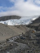
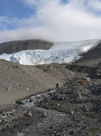
| Adams Stream | 78°6′S 163°45′E | A glacial meltwater Meltwater Meltwater is the water released by the melting of snow or ice, including glacial ice and ice shelfs over oceans. Meltwater is often found in the ablation zone of glaciers, where the rate of snow cover is reducing... stream Stream A stream is a body of water with a current, confined within a bed and stream banks. Depending on its locale or certain characteristics, a stream may be referred to as a branch, brook, beck, burn, creek, "crick", gill , kill, lick, rill, river, syke, bayou, rivulet, streamage, wash, run or... , 0.5 mile long. It flows from the snout of Adams Glacier Adams Glacier (Victoria Land) Adams Glacier is a small glacier immediately south of Miers Glacier in Victoria Land. The heads of Adams and Miers glaciers, both located in the Miers Valley, are separated by a low ridge, and the east end of this ridge is almost completely surrounded by the snouts of the two glaciers, which... into Lake Miers Lake Miers Lake Miers is a small lake in Miers Valley, lying east of the snouts of Miers and Adams Glaciers, and filled by meltwater from these glaciers. A stream from the lake flows down the valley in the warmest weather to reach the coast of Victoria Land. Named after Miers Glacier in 1957 by the New... in Miers Valley Miers Valley Miers Valley is a valley in the McMurdo Dry Valleys located just south of Marshall Valley and west of Koettlitz Glacier, on the coast of Victoria Land. The valley is ice-free in the Austral summer except for Miers Glacier and Adams Glacier in its upper part, and Lake Miers near its center... , Denton Hills Denton Hills The Denton Hills are a group of rugged foothills, 24 nautical miles long SW-NE and 9 nautical miles wide, to the east of Royal Society Range on Scott Coast, Victoria Land. The feature comprises a series of E-trending ridges and valleys circumscribed by Howchin Glacier, Armitage Saddle, Blue... , Scott Coast Scott Coast Scott Coast is that portion of the coast of Victoria Land between Cape Washington and Minna Bluff. Named by New Zealand Antarctic Place-Names Committee in 1961 after Captain Robert Falcon Scott, Royal Navy, leader of the Discovery expedition and the British Antarctic Expedition , who lost his... . Named in association with Adams Glacier. |
| Aiken Creek | 77°36′S 163°17′E | A glacial meltwater Meltwater Meltwater is the water released by the melting of snow or ice, including glacial ice and ice shelfs over oceans. Meltwater is often found in the ablation zone of glaciers, where the rate of snow cover is reducing... stream Stream A stream is a body of water with a current, confined within a bed and stream banks. Depending on its locale or certain characteristics, a stream may be referred to as a branch, brook, beck, burn, creek, "crick", gill , kill, lick, rill, river, syke, bayou, rivulet, streamage, wash, run or... in Taylor Valley Taylor Valley Taylor Valley is the southern one of the three large Dry Valleys in the Transantarctic Mountains, Victoria Land, located west of McMurdo Sound at approximately . The valley extends from Taylor Glacier in the west to McMurdo Sound at Explorers Cove at the northwest head of New Harbour in the east... , Victoria Land Victoria Land Victoria Land is a region of Antarctica bounded on the east by the Ross Ice Shelf and the Ross Sea and on the west by Oates Land and Wilkes Land. It was discovered by Captain James Clark Ross in January 1841 and named after the UK's Queen Victoria... , which flows north from the unnamed glacier Glacier A glacier is a large persistent body of ice that forms where the accumulation of snow exceeds its ablation over many years, often centuries. At least 0.1 km² in area and 50 m thick, but often much larger, a glacier slowly deforms and flows due to stresses induced by its weight... west of Wales Glacier Wales Glacier Wales Glacier is a short alpine glacier just west of Mount Barnes at the east end of the Kukri Hills. It drains north into Taylor Valley in Victoria Land. Named by the British Antarctic Expedition under Scott.... to Many Glaciers Pond Many Glaciers Pond Many Glaciers Pond is a pond, 0.3 nautical miles long, located 0.5 nautical miles south of the snout of Commonwealth Glacier in Taylor Valley, Victoria Land. The pond is part of the Aiken Creek system and receives drainage from several glaciers including Commonwealth Glacier, Wales Glacier and... , then west to Lake Fryxell Lake Fryxell Lake Fryxell is a lake long, between Canada Glacier and Commonwealth Glaciers at the lower end of Taylor Valley in Victoria Land, Antarctica. Mapped by the British Antarctic Expedition under Robert Falcon Scott, 1910-13, the lake was visited by Professor T.L. Péwé during USN Operation Deep Freeze,... . The feature is 4 miles (6 km) long and receives some tributary Tributary A tributary or affluent is a stream or river that flows into a main stem river or a lake. A tributary does not flow directly into a sea or ocean... flow from Wales Glacier. The name was suggested by hydrologist Diane McKnight, leader of the United States Geological Survey United States Geological Survey The United States Geological Survey is a scientific agency of the United States government. The scientists of the USGS study the landscape of the United States, its natural resources, and the natural hazards that threaten it. The organization has four major science disciplines, concerning biology,... (USGS) team which made extensive studies of the hydrology Hydrology Hydrology is the study of the movement, distribution, and quality of water on Earth and other planets, including the hydrologic cycle, water resources and environmental watershed sustainability... and geochemistry Geochemistry The field of geochemistry involves study of the chemical composition of the Earth and other planets, chemical processes and reactions that govern the composition of rocks, water, and soils, and the cycles of matter and energy that transport the Earth's chemical components in time and space, and... of streams and pond Pond A pond is a body of standing water, either natural or man-made, that is usually smaller than a lake. A wide variety of man-made bodies of water are classified as ponds, including water gardens, water features and koi ponds; all designed for aesthetic ornamentation as landscape or architectural... s in the Lake Fryxell basin, 1987-94. Named after USGS hydrologist George R. Aiken, a member of the field team in three summer seasons, 1987-91, who assisted in establishing stream gauging stations on the streams flowing into Lake Fryxell in the 1990-91 season. |
| Alph River Alph River Alph River is a small river of Antarctica, running into Walcott Bay, Victoria Land. It is located in an ice-free region at the west of the Koettlitz Glacier, Scott Coast. The Alph emerges from Trough Lake, and flows through Walcott Lake, Howchin Lake, and Alph Lake... |
A glacial meltwater Meltwater Meltwater is the water released by the melting of snow or ice, including glacial ice and ice shelfs over oceans. Meltwater is often found in the ablation zone of glaciers, where the rate of snow cover is reducing... stream Stream A stream is a body of water with a current, confined within a bed and stream banks. Depending on its locale or certain characteristics, a stream may be referred to as a branch, brook, beck, burn, creek, "crick", gill , kill, lick, rill, river, syke, bayou, rivulet, streamage, wash, run or... |
|
| Lawson Creek | 77°43′S 162°16′E | A glacial meltwater Meltwater Meltwater is the water released by the melting of snow or ice, including glacial ice and ice shelfs over oceans. Meltwater is often found in the ablation zone of glaciers, where the rate of snow cover is reducing... stream Stream A stream is a body of water with a current, confined within a bed and stream banks. Depending on its locale or certain characteristics, a stream may be referred to as a branch, brook, beck, burn, creek, "crick", gill , kill, lick, rill, river, syke, bayou, rivulet, streamage, wash, run or... , 400 m long, flowing southeast from the southwest tip of Rhone Glacier (Antarctica) Rhone Glacier (Antarctica) Rhone Glacier is a glacier lying west of Matterhorn Glacier and flowing south toward the junction of Lake Bonney and Taylor Glacier in Victoria Land. It was charted and named by the British Antarctic Expedition, 1910–13, under Robert Falcon Scott.... to the northwest corner of Lake Chad Lake Chad (Antarctica) Lake Chad is a small lake lying east of the mouth of Suess Glacier in the Taylor Valley of Victoria Land. It was charted by the British Antarctic Expedition, 1910–13, under Robert Falcon Scott, and named by them after the Lake Chad in Africa.... in Taylor Valley Taylor Valley Taylor Valley is the southern one of the three large Dry Valleys in the Transantarctic Mountains, Victoria Land, located west of McMurdo Sound at approximately . The valley extends from Taylor Glacier in the west to McMurdo Sound at Explorers Cove at the northwest head of New Harbour in the east... , Victoria Land Victoria Land Victoria Land is a region of Antarctica bounded on the east by the Ross Ice Shelf and the Ross Sea and on the west by Oates Land and Wilkes Land. It was discovered by Captain James Clark Ross in January 1841 and named after the UK's Queen Victoria... . Named by Advisory Committee on Antarctic Names Advisory Committee on Antarctic Names The Advisory Committee on Antarctic Names is an advisory committee of the United States Board on Geographic Names responsible for recommending names for features in Antarctica... (US-ACAN) in 1996 after Wendy Julia Lawson, glaciologist Glaciology Glaciology Glaciology Glaciology (from Middle French dialect (Franco-Provençal): glace, "ice"; or Latin: glacies, "frost, ice"; and Greek: λόγος, logos, "speech" lit... , University of Canterbury, New Zealand New Zealand New Zealand is an island country in the south-western Pacific Ocean comprising two main landmasses and numerous smaller islands. The country is situated some east of Australia across the Tasman Sea, and roughly south of the Pacific island nations of New Caledonia, Fiji, and Tonga... , leader of an expedition that studied glacial processes on Taylor Glacier Taylor Glacier The Taylor Glacier is an Antarctic glacier about long, flowing from the plateau of Victoria Land into the western end of Taylor Valley, north of the Kukri Hills, south of the Asgard Range... during the 1992 and 1993 summer seasons. |
| Onyx River Onyx River The Onyx River is a meltwater stream which flows westward through the Wright Valley from Wright Lower Glacier and Lake Brownworth at the foot of the glacier to Lake Vanda, during a few months of the Antarctic summer.... |
A glacial meltwater Meltwater Meltwater is the water released by the melting of snow or ice, including glacial ice and ice shelfs over oceans. Meltwater is often found in the ablation zone of glaciers, where the rate of snow cover is reducing... stream Stream A stream is a body of water with a current, confined within a bed and stream banks. Depending on its locale or certain characteristics, a stream may be referred to as a branch, brook, beck, burn, creek, "crick", gill , kill, lick, rill, river, syke, bayou, rivulet, streamage, wash, run or... |
|
| Priscu Stream | 77°39′S 162°45′E | A glacial meltwater Meltwater Meltwater is the water released by the melting of snow or ice, including glacial ice and ice shelfs over oceans. Meltwater is often found in the ablation zone of glaciers, where the rate of snow cover is reducing... stream Stream A stream is a body of water with a current, confined within a bed and stream banks. Depending on its locale or certain characteristics, a stream may be referred to as a branch, brook, beck, burn, creek, "crick", gill , kill, lick, rill, river, syke, bayou, rivulet, streamage, wash, run or... , 3.8 long, flowing southwest from southeast end of Lacroix Glacier Lacroix Glacier Lacroix Glacier is a glacier between Suess and Matterhorn Glaciers, which flows southeast into Taylor Valley in Victoria Land. It was mapped by the British Antarctic Expedition under Scott, 1910–13, and named after Alfred Lacroix, as was Mount Lacroix.... to the northeast end of East Lake Bonney Lake Bonney (Antarctica) Lake Bonney is a saline lake with permanent ice cover at the western end of Taylor Valley in the McMurdo Dry Valleys of Victoria Land, Antarctica.It is long and up to wide... in Taylor Valley Taylor Valley Taylor Valley is the southern one of the three large Dry Valleys in the Transantarctic Mountains, Victoria Land, located west of McMurdo Sound at approximately . The valley extends from Taylor Glacier in the west to McMurdo Sound at Explorers Cove at the northwest head of New Harbour in the east... , Victoria Land Victoria Land Victoria Land is a region of Antarctica bounded on the east by the Ross Ice Shelf and the Ross Sea and on the west by Oates Land and Wilkes Land. It was discovered by Captain James Clark Ross in January 1841 and named after the UK's Queen Victoria... . It is also fed from Solls Glacier (via Bohner Stream Bohner Stream Bohner Stream is a meltwater stream, long, flowing north from the south end of Sollas Glacier to Priscu Stream in Taylor Valley, Victoria Land. It was named by the Advisory Committee on Antarctic Names in 1996 after Lieutenant Commander Robert T. Bohner, U.S... ), and by Doran Stream Doran Stream Doran Stream is a meltwater stream, 3,000 m long, flowing north from an unnamed alpine glacier east of Sollas Glacier to Priscu Stream in Taylor Valley, Victoria Land. Named by Advisory Committee on Antarctic Names in 1996 after Peter T... (3 km), and flows through Spiegel Pond. Named by Advisory Committee on Antarctic Names Advisory Committee on Antarctic Names The Advisory Committee on Antarctic Names is an advisory committee of the United States Board on Geographic Names responsible for recommending names for features in Antarctica... (US-ACAN) in 1996 after John C. Priscu, ecologist, Montana State University Montana State University - Bozeman Montana State University – Bozeman is a public university located in Bozeman, Montana. It is the state's land-grant university and primary campus in the Montana State University System, which is part of the Montana University System... ; principal investigator from 1984 on numerous studies of marine and fresh water systems in the McMurdo region and the author of numerous papers on the ecology of this area; led first WINFLY expedition (1991) into the McMurdo Dry Valleys McMurdo Dry Valleys The McMurdo Dry Valleys are a row of snow-free valleys in Antarctica located within Victoria Land west of McMurdo Sound. The region is one of the world's most extreme deserts, and includes many interesting features including Lake Vida and the Onyx River, Antarctica's longest river.-Climate:The Dry... . |
| Rezovski Creek Rezovski Creek Rezovski Creek is a melt-water stream located on Livingston Island, Antarctica.The 500 m long melt-water stream draining that portion of the northwestern slope of Balkan Snowfield located between Hesperides Hill, Atlantic Club Ridge, Krum Rock and Sinemorets Hill on Hurd Peninsula in eastern... |
62°38′28"S 60°21′57"W | A glacial meltwater Meltwater Meltwater is the water released by the melting of snow or ice, including glacial ice and ice shelfs over oceans. Meltwater is often found in the ablation zone of glaciers, where the rate of snow cover is reducing... stream Stream A stream is a body of water with a current, confined within a bed and stream banks. Depending on its locale or certain characteristics, a stream may be referred to as a branch, brook, beck, burn, creek, "crick", gill , kill, lick, rill, river, syke, bayou, rivulet, streamage, wash, run or... , 500 m long, draining that portion of the northwestern slope of Balkan Snowfield Balkan Snowfield Balkan Snowfield is an ice-covered plateau ranging from 150 to 280 m in eastern Livingston Island in the South Shetland Islands, Western Antarctica... located between Hesperides Hill Hesperides Hill Hesperides Hill is a ridge linked by a saddle of elevation 52 m with the northern slopes of Atlantic Club Ridge on Hurd Peninsula, eastern Livingston Island in the South Shetland Islands, Antarctica... , Atlantic Club Ridge Atlantic Club Ridge The Atlantic Club Ridge is a ridge rising to 161 m on Hurd Peninsula in Eastern Livingston Island, Antarctica... , Krum Rock Krum Rock Krum Rock is a small nunatak rising to 208 metres on the southwest edge of Balkan Snowfield just north of Contell Glacier on Hurd Peninsula in eastern Livingston Island, one of the South Shetland Islands in Western Antarctica. The rock projects slightly above the ice sheet with some 3,000 square... and Sinemorets Hill Sinemorets Hill Sinemorets Hill is the second most prominent in the chain of hills surmounting Bulgarian Beach in eastern Livingston Island in the South Shetland Islands, Antarctica.... in eastern Livingston Island. The arms of Rezovski Creek encompass the old buildings of the Bulgarian Base St. Kliment Ohridski Base St. Kliment Ohridski Base is a Bulgarian Antarctic base on Livingston Island in the South Shetland Islands.The base, originally known as Sofia University Refuge, was named in 1993 "for St... . Its lower course forms the Grand Lagoon Grand Lagoon Grand Lagoon is a freshwater lagoon of elevation on Bulgarian Beach, Hurd Peninsula in eastern Livingston Island, in the South Shetland Islands, Antarctica. Formed by Rezovski Creek and separated from sea by a moraine of elevation near . Surmounted by Pesyakov Hill... , and has its mouth at the southwest extremity of Bulgarian Beach Bulgarian Beach Bulgarian Beach is a coast in the north part of Hurd Peninsula, eastern Livingston Island, extending 2.3 km from Hespérides Point to the southwest to Perunika Glacier to the northeast, and forming the southeast coast of Emona Anchorage.The beach comprises four predominantly boulder beaches,... used as embarkation place servicing St. Kliment Ohridski Base St. Kliment Ohridski Base St. Kliment Ohridski Base is a Bulgarian Antarctic base on Livingston Island in the South Shetland Islands.The base, originally known as Sofia University Refuge, was named in 1993 "for St... . Named on 29 October 1996 after Rezovska River in southeastern Bulgaria; the name was established in use at the time of approval. |
| Surko Stream | 77°25′S 163°44′E | A glacial meltwater Meltwater Meltwater is the water released by the melting of snow or ice, including glacial ice and ice shelfs over oceans. Meltwater is often found in the ablation zone of glaciers, where the rate of snow cover is reducing... stream Stream A stream is a body of water with a current, confined within a bed and stream banks. Depending on its locale or certain characteristics, a stream may be referred to as a branch, brook, beck, burn, creek, "crick", gill , kill, lick, rill, river, syke, bayou, rivulet, streamage, wash, run or... , 1 mile (1.6 km) south of Gneiss Point Gneiss Point Gneiss Point is a rocky point 2 nautical miles north of Marble Point, on the coast of Victoria Land. First mapped by the British Antarctic Expedition under Scott and so named because of gneissic granite found here.... on the coast of Victoria Land Victoria Land Victoria Land is a region of Antarctica bounded on the east by the Ross Ice Shelf and the Ross Sea and on the west by Oates Land and Wilkes Land. It was discovered by Captain James Clark Ross in January 1841 and named after the UK's Queen Victoria... . It issues from the front of Wilson Piedmont Glacier Wilson Piedmont Glacier Wilson Piedmont Glacier is a large piedmont glacier extending from Granite Harbour to Marble Point on the coast of Victoria Land. Discovered by the Discovery expedition, 1901-04. The British Antarctic Expedition, 1910–13, named the feature for Dr. Edward A. Wilson, surgeon and artist with Scott's... and flows eastward to Arnold Cove Arnold Cove Arnold Cove is a cove along the west margin of McMurdo Sound between Gneiss Point and Marble Point, Victoria Land. It was named by the Advisory Committee on Antarctic Names for Charles L. Arnold, leader of a United States Antarctic Research Program party that made an engineering study of Marble... . The stream was studied by Robert L. Nichols, geologist for Metcalf and Eddy, Engineers, Boston, MA, which made engineering studies here under contract to the U.S. Navy in the 1960-61 season. Named by Nichols for Lieutenant Alexander Surko, U.S. Navy, second-in-command of the Navy party that worked on the aircraft landing strip close north of this stream. |