

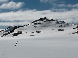
Sinemorets Hill
Encyclopedia
Hesperides Hill
Hesperides Hill is a ridge linked by a saddle of elevation 52 m with the northern slopes of Atlantic Club Ridge on Hurd Peninsula, eastern Livingston Island in the South Shetland Islands, Antarctica...
) in the chain of hills surmounting Bulgarian Beach
Bulgarian Beach
Bulgarian Beach is a coast in the north part of Hurd Peninsula, eastern Livingston Island, extending 2.3 km from Hespérides Point to the southwest to Perunika Glacier to the northeast, and forming the southeast coast of Emona Anchorage.The beach comprises four predominantly boulder beaches,...
in eastern Livingston Island in the South Shetland Islands
South Shetland Islands
The South Shetland Islands are a group of Antarctic islands, lying about north of the Antarctic Peninsula, with a total area of . By the Antarctic Treaty of 1959, the Islands' sovereignty is neither recognized nor disputed by the signatories and they are free for use by any signatory for...
, Antarctica.
Sinemorets Hill is 380 m long in east-west direction and 230 m wide, with twin heights, the west-southwestern one being 64 m and the east-northeastern one 62 m, sheltering a small pool between them. It is snow free in the summer months and overlooks the Bulgarian base
St. Kliment Ohridski Base
St. Kliment Ohridski Base is a Bulgarian Antarctic base on Livingston Island in the South Shetland Islands.The base, originally known as Sofia University Refuge, was named in 1993 "for St...
to the southwest. Relics of an old encampment were still discernible at its eastern slope in 1996.
Sinemorets
Sinemorets
Sinemorets is a village and seaside resort on the Black Sea coast of Bulgaria, located in the very southeast of the country close to the border with Turkey, where the river Veleka flows into the sea. Sinemorets is part of Tsarevo municipality, Burgas Province, and has a population of 216...
is the name of a village and a cape on the Black Sea
Black Sea
The Black Sea is bounded by Europe, Anatolia and the Caucasus and is ultimately connected to the Atlantic Ocean via the Mediterranean and the Aegean seas and various straits. The Bosphorus strait connects it to the Sea of Marmara, and the strait of the Dardanelles connects that sea to the Aegean...
coast. The hill was named by the United Kingdom Antarctic Place-Names Committee (UK-APC) in 1994 at the request of the Second Bulgarian Antarctic Expedition (1993/94).
Location
The peak is located at 62°38′25"S 60°21′42"W which is 820 m east-northeast of Hespérides PointHespérides Point
Hespérides Point is a rocky point of land projecting into South Bay north-northwest of Johnsons Dock, Livingston Island in the South Shetland Islands, Antarctica and forming the southwest side of the entrance to Emona Anchorage. Surmounted by Hesperides Hill...
, 220 m inland from Greenpeace Rock, 1.2 km northwest of Krum Rock
Krum Rock
Krum Rock is a small nunatak rising to 208 metres on the southwest edge of Balkan Snowfield just north of Contell Glacier on Hurd Peninsula in eastern Livingston Island, one of the South Shetland Islands in Western Antarctica. The rock projects slightly above the ice sheet with some 3,000 square...
and 970 m north-northeast of Atlantic Club Ridge
Atlantic Club Ridge
The Atlantic Club Ridge is a ridge rising to 161 m on Hurd Peninsula in Eastern Livingston Island, Antarctica...
. Mapped in detail by the Spanish Servicio Geográfico del Ejército in 1991, Bulgarian mapping in 1996, 2005 and 2009. Co-ordinates, elevation and distances given according to a 1995-96 Bulgarian topographic survey.
Maps
- Isla Livingston: Península Hurd. Mapa topográfico de escala 1:25 000. Madrid: Servicio Geográfico del Ejército, 1991.
- L.L. Ivanov. Livingston Island: Central-Eastern Region. Scale 1:25000 topographic map. Sofia: Antarctic Place-names Commission of Bulgaria, 1996.
- L.L. Ivanov et al. Antarctica: Livingston Island and Greenwich Island, South Shetland Islands. Scale 1:100000 topographic map. Sofia: Antarctic Place-names Commission of Bulgaria, 2005.
- L.L. Ivanov. Antarctica: Livingston Island and Greenwich, Robert, Snow and Smith Islands. Scale 1:120000 topographic map. Troyan: Manfred Wörner Foundation, 2009. ISBN 978-954-92032-6-4