

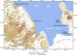
McMurdo Dry Valleys
Encyclopedia
- "Dry Valleys" redirects here. For other uses, see dry valleyDry valleyA dry valley is a valley found in either karst or chalk terrain that no longer has a surface flow of water.There are many examples of the latter along the North and South Downs in southern England...
Antarctic oasis
An Antarctic oasis is a large area naturally free of snow and ice in the otherwise ice-covered continent of Antarctica.-Geology:In Antarctica there are, in addition to mountain tops and nunataks, other natural snow- and ice-free areas often referred to as "Antarctic oases" or "dry valleys"...
valleys in Antarctica located within Victoria Land
Victoria Land
Victoria Land is a region of Antarctica bounded on the east by the Ross Ice Shelf and the Ross Sea and on the west by Oates Land and Wilkes Land. It was discovered by Captain James Clark Ross in January 1841 and named after the UK's Queen Victoria...
west of McMurdo Sound
McMurdo Sound
The ice-clogged waters of Antarctica's McMurdo Sound extend about 55 km long and wide. The sound opens into the Ross Sea to the north. The Royal Society Range rises from sea level to 13,205 feet on the western shoreline. The nearby McMurdo Ice Shelf scribes McMurdo Sound's southern boundary...
. The region is one of the world's most extreme desert
Desert
A desert is a landscape or region that receives an extremely low amount of precipitation, less than enough to support growth of most plants. Most deserts have an average annual precipitation of less than...
s, and includes many interesting features including Lake Vida
Lake Vida
Lake Vida is a hypersaline lake in Victoria Valley, the northernmost of the large McMurdo Dry Valleys, on the continent of Antarctica. It is isolated under year-round ice cover, and is considerably more saline than seawater...
and the Onyx River
Onyx River
The Onyx River is a meltwater stream which flows westward through the Wright Valley from Wright Lower Glacier and Lake Brownworth at the foot of the glacier to Lake Vanda, during a few months of the Antarctic summer....
, Antarctica's longest river
River
A river is a natural watercourse, usually freshwater, flowing towards an ocean, a lake, a sea, or another river. In a few cases, a river simply flows into the ground or dries up completely before reaching another body of water. Small rivers may also be called by several other names, including...
.
Climate
The Dry Valleys are so named because of their extremely low humidityHumidity
Humidity is a term for the amount of water vapor in the air, and can refer to any one of several measurements of humidity. Formally, humid air is not "moist air" but a mixture of water vapor and other constituents of air, and humidity is defined in terms of the water content of this mixture,...
and their lack of snow or ice cover. They are also dry because, in this location, the mountains are sufficiently high that they block seaward flowing ice from the East Antarctic ice sheet from reaching the Ross Sea. At 4800 square kilometre, the valleys constitute around 0.03% of the continent, and form the largest ice-free region in Antarctica. The valley floors are covered with loose gravel, in which ice wedge
Ice wedge
An ice wedge is a crack in the ground formed by a narrow or thin piece of ice that measures up to 3-4 metres wide at ground level and extends downwards into the ground up to several metres. During the winter months, the water in the ground freezes and expands...
polygonal patterned ground may be observed.
The unique conditions in the Dry Valleys are caused, in part, by katabatic winds; these occur when cold, dense air is pulled downhill by the force of gravity. The winds can reach speeds of 320 kilometre per hour, heating as they descend, and evaporating all water, ice and snow.
Geology
The valleys cut through the Beacon sandstoneBeacon sandstone
The Beacon sandstone is a geological formation exposed in Antarctica and deposited from the Devonian to the Triassic . The sandstone was originally described as a formation, and upgraded to group and supergroup as time passed. It contains a sandy member known as the Beacon heights...
, as well as older granites and gneisses of the Ross Orogeny. Tills, deposited directly from ice, dot this bedrock landscape. These tills are relatively thin and patchy, and differ markedly from the extensive, mud-rich tills of the Laurentide ice sheet in the Northern Hemisphere. One reason for the difference is that most of the tills in the Dry Valleys were deposited from cold-based ice (ice with basal temperatures below 0 °C (32 °F)), whereas the Laurentide ice sheet was largely wet-based, with significant melting at the base and at the glacier surface.
Biota
Endolith
An endolith is an organism that lives inside rock, coral, animal shells, or in the pores between mineral grains of a rock. Many are extremophiles, living in places previously thought inhospitable to life...
ic photosynthetic
Photosynthesis
Photosynthesis is a chemical process that converts carbon dioxide into organic compounds, especially sugars, using the energy from sunlight. Photosynthesis occurs in plants, algae, and many species of bacteria, but not in archaea. Photosynthetic organisms are called photoautotrophs, since they can...
bacteria have been found living in the Dry Valleys, sheltered from the dry air in the relatively moist interior of rocks. Summer meltwater from the glaciers provides the primary source of soil nutrients. Scientists consider the Dry Valleys perhaps the closest of any terrestrial environment to the planet Mars
Mars
Mars is the fourth planet from the Sun in the Solar System. The planet is named after the Roman god of war, Mars. It is often described as the "Red Planet", as the iron oxide prevalent on its surface gives it a reddish appearance...
, and thus an important source of insights into possible extraterrestrial life
Extraterrestrial life
Extraterrestrial life is defined as life that does not originate from Earth...
.
Anaerobic
Anaerobic organism
An anaerobic organism or anaerobe is any organism that does not require oxygen for growth. It could possibly react negatively and may even die if oxygen is present...
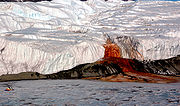
bacteria whose metabolism is based on iron and sulfur live in sub-freezing temperatures under the Taylor Glacier
Taylor Glacier
The Taylor Glacier is an Antarctic glacier about long, flowing from the plateau of Victoria Land into the western end of Taylor Valley, north of the Kukri Hills, south of the Asgard Range...
, staining red the ice emerging at Blood Falls
Blood Falls
Blood Falls is an outflow of an iron oxide-tainted plume of saltwater, occurring at the tongue of the Taylor Glacier onto the ice-covered surface of West Lake Bonney in the Taylor Valley of the McMurdo Dry Valleys in Victoria Land, East Antarctica....
.
Part of the Valleys was designated an environmentally protected area in 2004.
Valleys
- Alatna ValleyAlatna ValleyAlatna Valley is an ice-free valley lying north of Mount Gran and trending east-northeast for about along the southeast side of the Convoy Range. It is one of the northernmost of the McMurdo Dry Valleys. Parker Calkin, U.S. geologist, made stratigraphic studies in the valley during the...
(sometimes incorrectly spelled Atlanta Valley) is the northernmost, north of Benson GlacierBenson GlacierBenson Glacier is a glacier about long, draining the east part of Flight Deck Neve and continuing east between Fry Glacier and Mackay Glacier into the north part of Granite Harbour where it forms a floating tongue...
.
From north to south, the three main valleys are
- Victoria ValleyVictoria ValleyVictoria Valley is one of the larger McMurdo Dry Valleys. Lake Vida is the largest lake of the valley. The Victoria River drains the Upper Victoria Glacier, with Upper Victoria Lake just below it and northwest of Lake Vida, into Vida Lake on its western side. Lake Thomas is east of Lake Vida....
(between St. Johns RangeSaint Johns RangeSaint Johns Range is a crescent-shaped mountain range about long, in Victoria Land. It is bounded on the north by the Cotton, Miller and Debenham Glaciers, and on the south by Victoria Valley and the Victoria Upper and Victoria Lower Glaciers. Named by the New Zealand Northern Survey Party of the...
in the north and Olympus RangeOlympus RangeOlympus Range is a primarily ice-free mountain range of Victoria Land with peaks over , between Victoria and McKelvey Valleys on the north and Wright Valley on the south. Mapped by the Victoria University of Wellington Antarctic Expedition , 1958–59, and named for the mythological home of the...
in the south) - Wright ValleyWright ValleyThe Wright Valley is the central one of the three large Dry Valleys in the Transantarctic Mountains, located west of McMurdo Sound at approximately . Wright Valley contains the Onyx River, the largest river in Antarctica, Lake Brownworth, the origin of Onyx River, and Lake Vanda, which is fed by...
(between Olympus RangeOlympus RangeOlympus Range is a primarily ice-free mountain range of Victoria Land with peaks over , between Victoria and McKelvey Valleys on the north and Wright Valley on the south. Mapped by the Victoria University of Wellington Antarctic Expedition , 1958–59, and named for the mythological home of the...
in the north and Asgard RangeAsgard RangeThe Asgard Range is a mountain range in Victoria Land, Antarctica. It dividies Wright Valley from Taylor Glacier and Taylor Valley, and was named by the Victoria University of Wellington Antarctic Expedition after Asgard, the home of the Norse gods....
in the south) - Taylor ValleyTaylor ValleyTaylor Valley is the southern one of the three large Dry Valleys in the Transantarctic Mountains, Victoria Land, located west of McMurdo Sound at approximately . The valley extends from Taylor Glacier in the west to McMurdo Sound at Explorers Cove at the northwest head of New Harbour in the east...
(between Asgard RangeAsgard RangeThe Asgard Range is a mountain range in Victoria Land, Antarctica. It dividies Wright Valley from Taylor Glacier and Taylor Valley, and was named by the Victoria University of Wellington Antarctic Expedition after Asgard, the home of the Norse gods....
in the north and Kukri HillsKukri HillsKukri Hills is a prominent east-west trending range, about long and over high, forming the divide between Ferrar Glacier on the south and Taylor Glacier and Taylor Valley on the north, in Victoria Land, Antarctica....
in the south)
West of Victoria Valley are, from north to south,
- Barwick ValleyBarwick ValleyBarwick Valley is an ice-free valley north of Apocalypse Peaks, extending from Webb Glacier to Victoria Valley in Victoria Land. It was named by the Victoria University of Wellington Antarctic Expedition for R.E...
- Balham ValleyBalham ValleyBalham Valley is an ice-free valley between the Insel Range and the Apocalypse Peaks, in Victoria Land. It was named by the Victoria University of Wellington Antarctic Expedition for R.W. Balham, biologist with the New Zealand party of the Commonwealth Trans-Antarctic Expedition who did the first...
- McKelvey ValleyMcKelvey ValleyMcKelvey Valley is a valley between the western part of the Olympus Range and the Insel Range, in Victoria Land. It was named by the Victoria University of Wellington Antarctic Expedition for B.C. McKelvey, a geologist of Victoria University of Wellington, who, with P.N...
Stretching south from Balham Valley are, from west to east:
- Priscu ValleyPriscu ValleyPriscu Valley is an upland ice-free valley on the east side of Prentice Plateau in Antarctica's Olympus Range. The valley opens north to the head of McKelvey Valley. Named by Advisory Committee on Antarctic Names after John C...
- Wall ValleyWall ValleyWall Valley is an upland valley next east of Priscu Valley in Olympus Range; Minotaur Pass is at the head between Apollo Peak and Mount Electra. The valley opens north to McKelvey Valley...
- Virginia ValleyVirginia ValleyVirginia Valley is an upland valley east of Wall valley in Olympus Range, located between the north part of Mount Electra on the west, and Mount Circe and Mount Dido on the east. The valley opens north to McKelvey Valley. Named by Advisory Committee on Antarctic Names after Ross A...
- Stuiver ValleyStuiver ValleyStuiver Valley is a high hanging valley, largely ice free, between Mount Circe and Mount Dido on the west and Mount Boreas on the east, in the Olympus Range, Victoria Land...
West of Taylor Valley is
- Pearse ValleyPearse ValleyPearse Valley is an ice-free valley long, lying immediately west of Catspaw Glacier, at the south side of the Asgard Range in Victoria Land. Named by Advisory Committee on Antarctic Names for John S. Pearse, biologist at McMurdo Station, 1961, and the season 1961-62....
(sometimes incorrectly spelled Pearce Valley).
Further south, between Royal Society Range
Royal Society Range
The Royal Society Range is a majestic mountain range in Victoria Land, Antarctica. With its summit at , the massive Mount Lister forms the highest point in this range. Mount Lister is located along the western shore of McMurdo Sound between the Koettlitz, Skelton and Ferrar glaciers...
in the west and the west coast of McMurdo Sound
McMurdo Sound
The ice-clogged waters of Antarctica's McMurdo Sound extend about 55 km long and wide. The sound opens into the Ross Sea to the north. The Royal Society Range rises from sea level to 13,205 feet on the western shoreline. The nearby McMurdo Ice Shelf scribes McMurdo Sound's southern boundary...
at the lobe of Koettlitz Glacier
Koettlitz Glacier
The Koettlitz Glacier is a large Antarctic glacier lying west of Mount Morning and Mount Discovery, flowing from the vicinity of Mount Cocks northeastward between Brown Peninsula and the mainland into the ice shelf of McMurdo Sound....
are, from north to south:
- Garwood ValleyGarwood ValleyGarwood Valley is a valley opening on the coast of Victoria Land just south of Cape Chocolate. It is largely ice-free, but is occupied near its head by the Garwood Glacier. Named by Taylor of the British Antarctic Expedition in association with Garwood Glacier....
- Marshall ValleyMarshall ValleyMarshall Valley is a small valley, which is ice free except for Rivard Glacier at its head, lying between the Garwood and Miers Valleys on the coast of Victoria Land. Named by the New Zealand Blue Glacier Party for Dr. Eric Marshall, surgeon and cartographer of the British Antarctic Expedition ,...
- Miers ValleyMiers ValleyMiers Valley is a valley in the McMurdo Dry Valleys located just south of Marshall Valley and west of Koettlitz Glacier, on the coast of Victoria Land. The valley is ice-free in the Austral summer except for Miers Glacier and Adams Glacier in its upper part, and Lake Miers near its center...
Lakes
Some of the lakes of the Dry Valleys rank among the world's most saline lakes, with a higher salinity than Lake Assal (Djibouti) or the Dead SeaDead Sea
The Dead Sea , also called the Salt Sea, is a salt lake bordering Jordan to the east and Israel and the West Bank to the west. Its surface and shores are below sea level, the lowest elevation on the Earth's surface. The Dead Sea is deep, the deepest hypersaline lake in the world...
. The most saline of all is small Don Juan Pond
Don Juan Pond
Don Juan Pond, also called Lake Don Juan, is a small and very shallow hypersaline lake in the west end of Wright Valley , Victoria Land, Antarctica, west from Lake Vanda. It is wedged between the Asgard Range in the south and the Dais in the north. On the west end there is a small tributary and a...
.
- Lake VidaLake VidaLake Vida is a hypersaline lake in Victoria Valley, the northernmost of the large McMurdo Dry Valleys, on the continent of Antarctica. It is isolated under year-round ice cover, and is considerably more saline than seawater...
(Victoria Valley)
- Lake VandaLake VandaLake Vanda is a lake in Wright Valley, Victoria Land, Ross Dependency, Antarctica. The lake is 5 km long and has a maximum depth of 69 m. On its shore, New Zealand maintained Vanda Station from 1968 to 1995...
(Wright Valley) - Lake BrownworthLake BrownworthLake Brownworth is a meltwater lake immediately west of Wright Lower Glacier at the east end of Wright Valley, Victoria Land. The lake was mapped by the United States Geological Survey from surveys and air photos obtained in 1956–60. It was named by the Advisory Committee on Antarctic Names for...
(Wright Valley) (freshwater) - Don Juan PondDon Juan PondDon Juan Pond, also called Lake Don Juan, is a small and very shallow hypersaline lake in the west end of Wright Valley , Victoria Land, Antarctica, west from Lake Vanda. It is wedged between the Asgard Range in the south and the Dais in the north. On the west end there is a small tributary and a...
(Wright Valley)
- Lake FryxellLake FryxellLake Fryxell is a lake long, between Canada Glacier and Commonwealth Glaciers at the lower end of Taylor Valley in Victoria Land, Antarctica. Mapped by the British Antarctic Expedition under Robert Falcon Scott, 1910-13, the lake was visited by Professor T.L. Péwé during USN Operation Deep Freeze,...
(Taylor Valley) - Lake HoareLake HoareLake Hoare is a lake about long between Lake Chad and Canada Glacier in Taylor Valley, Victoria Land. Its surface area measures . It was named by the 8th Victoria University of Wellington Antarctic Expedition , 1963–64, for physicist R.A...
(Taylor Valley) - Lake ChadLake Chad (Antarctica)Lake Chad is a small lake lying east of the mouth of Suess Glacier in the Taylor Valley of Victoria Land. It was charted by the British Antarctic Expedition, 1910–13, under Robert Falcon Scott, and named by them after the Lake Chad in Africa....
(Taylor Valley) - Dirty Little Hoare Pond (Taylor Valley)
- Parera Pond (Taylor Valley) (freshwater)
- Lake BonneyLake Bonney (Antarctica)Lake Bonney is a saline lake with permanent ice cover at the western end of Taylor Valley in the McMurdo Dry Valleys of Victoria Land, Antarctica.It is long and up to wide...
(Taylor Valley)
- Lake JoyceLake JoyceLake Joyce is a lake which lies along the northern side of Taylor Glacier in Pearse Valley, Victoria Land. It is ) long, deep and is covered by of very clear ice...
(Pearse Valley)
- Lake GarwoodLake GarwoodLake Garwood is a lake of Antarctica, named in association with Garwood Valley....
(Garwood Valley) - Lake MiersLake MiersLake Miers is a small lake in Miers Valley, lying east of the snouts of Miers and Adams Glaciers, and filled by meltwater from these glaciers. A stream from the lake flows down the valley in the warmest weather to reach the coast of Victoria Land. Named after Miers Glacier in 1957 by the New...
(Miers Valley)
Rivers
- Kite StreamKite StreamKite Stream is a meltwater stream in the Victoria Valley, Victoria Land, that flows west from Victoria Lower Glacier into Lake Vida. Named by Advisory Committee on Antarctic Names after James Steven Kite, University of Maine, geological field assistant with the Victoria Valley party, 1977-78...
(Victoria Valley) - Onyx RiverOnyx RiverThe Onyx River is a meltwater stream which flows westward through the Wright Valley from Wright Lower Glacier and Lake Brownworth at the foot of the glacier to Lake Vanda, during a few months of the Antarctic summer....
(Wright Valley) - Vincent CreekVincent CreekVincent Creek is a meltwater stream, long, flowing north from the north end of Hughes Glacier to the south edge of Lake Bonney in Taylor Valley, Victoria Land. Named by Advisory Committee on Antarctic Names in 1996 after Warwick F...
(Taylor Valley) - Crescent StreamCrescent StreamCrescent Stream is a glacial meltwater stream, long, flowing north from Crescent Glacier to the south-central shore of Lake Fryxell, in Taylor Valley, Victoria Land. Named in association with Crescent Glacier...
(Taylor Valley) - Harnish CreekHarnish CreekHarnish Creek is a meltwater stream, long, that flows north from the unnamed glacier east of Crescent Glacier into the east part of Lake Fryxell, Taylor Valley, in Victoria Land...
(Taylor Valley) - Huey CreekHuey CreekHuey Creek is a glacial meltwater stream, long, flowing south from an ice field west of Mount Falconer to the north-central shore of Lake Fryxell, in Taylor Valley, Victoria Land. The name was suggested by hydrologist Diane McKnight, leader of a United States Geological Survey team that made...
(Taylor Valley)
External links
- Map of the McMurdo Dry Valleys area (pdf)
- Another map (USGSUnited States Geological SurveyThe United States Geological Survey is a scientific agency of the United States government. The scientists of the USGS study the landscape of the United States, its natural resources, and the natural hazards that threaten it. The organization has four major science disciplines, concerning biology,...
) - Antarctic Connection
- Study: Life in Antarctic ice may compare to Mars
- Special Report: The McMurdo Dry Valleys, Antarctic Sun, January 26, 2003, 7–21.
- Virtual Tour of the Dry Valleys
- In Antarctica's Dry Valleys, worms offer clues to alarming changes in ecosystem - The New York Times/International Herald Tribune, November 2006
- A long-term ecological research group is working in the area.
- Pictures from the Dry Valleys
- Satellite images