

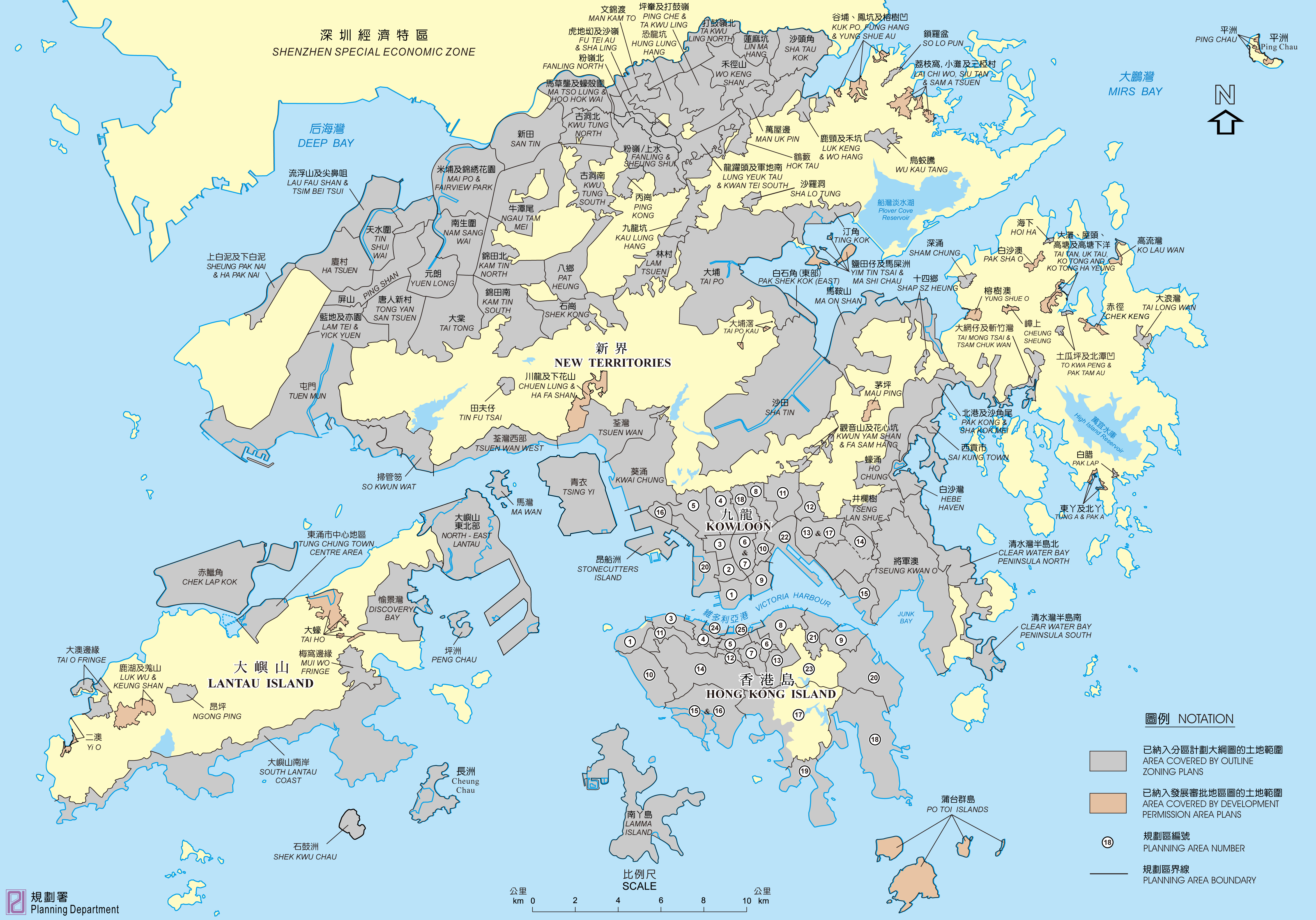
List of planning areas in Hong Kong
Encyclopedia
Hong Kong Planning Areas (HPA)
- Kennedy TownKennedy TownKennedy Town is at the western end of Sai Wan on Hong Kong Island in Hong Kong. It was named after Arthur Edward Kennedy, the 7th Governor of Hong Kong from 1872 to 1877...
and Mount DavisMount Davis, Hong KongMount Davis is a hill in Kennedy Town, Hong Kong Island, Hong Kong. It is the westernmost hill on Hong Kong Island.It is named after John Francis Davis, who was the 2nd Governor of Hong Kong, from 1844 to 1848....
(HPA 1) - Sai Ying PunSai Ying PunSai Ying Pun is an area in Western District on the Hong Kong Island in Hong Kong. It is part of Central and Western District in district administration....
and Sheung WanSheung WanSheung Wan is an area in Hong Kong, located in the north-west of Hong Kong Island, between Central and Sai Ying Pun. Administratively, it is part of the Central and Western District...
(HPA 3) - Central DistrictCentral, Hong KongCentral is the central business district of Hong Kong. It is located in Central and Western District, on the north shore of Hong Kong Island, across Victoria Harbour from Tsim Sha Tsui, the southernmost point of Kowloon Peninsula...
(HPA 4) - Wan ChaiWan ChaiWan Chai is a metropolitan area situated at the western part of the Wan Chai District on the northern shore of Hong Kong Island, in Hong Kong. Its other boundaries are Canal Road to the east, Arsenal Street to the west and Bowen Road to the south. The area north of Gloucester Road is often called...
(HPA 5) - Causeway BayCauseway BayCauseway Bay is a heavily built-up area of Hong Kong, People's Republic of China, located on the Hong Kong Island, and covering parts of Wan Chai and Eastern districts. The Chinese name is also romanized as Tung Lo Wan as in Tung Lo Wan Road...
(HPA 6) - Wong Nai Chung (HPA 7)
- North PointNorth PointNorth Point is a mixed-use urban area in the Eastern District of Hong Kong. It is the northernmost point of Hong Kong Island, adjacent to both Causeway Bay and Quarry Bay, and projecting toward Kowloon Bay. Fortress Hill occupies the western end of the North Point area.-History:In 1899, The...
(HPA 8) - Shau Kei WanShau Kei WanShau Kei Wan or Shaukeiwan, Shaukiwan is a town in Eastern District, Hong Kong. Literally, Shau Kei means a pail, and Wan implies that the town is developed along the coast. Nowadays it is a relatively densely populated town compared with some developing areas.-Name:The name Shau Kei Wan comes...
(HPA 9) - Pok Fu LamPok Fu LamPok Fu Lam or Pokfulam is a residential area on Hong Kong Island, at the western end of the Southern District.Pok Fu Lam is a valley between Victoria Peak and Mount Kellet, around Telegraph Bay....
(HPA 10) - Mid-levelsMid-levelsMid-levels is an expensive residential area on Hong Kong Island in Hong Kong. It is located halfway up Victoria Peak, directly above Central...
West (HPA 11) - Mid-levelsMid-levelsMid-levels is an expensive residential area on Hong Kong Island in Hong Kong. It is located halfway up Victoria Peak, directly above Central...
East (HPA 12) - Jardine's LookoutJardine's LookoutJardine's Lookout is a mountain and a residential area on the Hong Kong Island in Hong Kong. It is located Southeast of the Wan Chai district and South of the Tai Hang area, at an altitude of about 433 metres. Nearby hills include Mount Nicholson, Violet Hill and Mount Butler etc.It is named after...
and Wong Nai Chung GapWong Nai Chung GapWong Nai Chung Gap is a geographic gap in the middle of Hong Kong Island in Hong Kong. The gap is between Mount Nicholson and Jardine's Lookout behind Wong Nai Chung. Five roads meet at the Gap Wong Nai Chung Gap Road, Tai Tam Reservoir Road, Repulse Bay Road, Deep Water Bay Road and Black's Link...
(HPA 13) - The Peak AreaVictoria PeakVictoria Peak is a mountain in Hong Kong. It is also known as Mount Austin, and locally as The Peak. The mountain is located in the western half of Hong Kong Island...
(HPA 14) - AberdeenAberdeenAberdeen is Scotland's third most populous city, one of Scotland's 32 local government council areas and the United Kingdom's 25th most populous city, with an official population estimate of ....
and Ap Lei ChauAp Lei ChauAp Lei Chau , or Aberdeen Island, is an island of Hong Kong, located south-west of Hong Kong Island, next to Aberdeen Harbour and Aberdeen Channel, with an area of 1.30 km². Administratively, it is part of Southern District. Ap Lei Chau is the third most densely populated island in the world.-...
(HPA 15 and 16) - Shouson HillShouson HillShouson Hill is a hill on the coast of Deep Water Bay east of Wong Chuk Hang on Hong Kong Island in Hong Kong. It is also an upmarket residential area located just to the north of the hill...
and Repulse BayRepulse BayRepulse Bay is a bay in the southern part of Hong Kong Island, located in the Southern District, Hong Kong.-Geography:Repulse Bay is located in the south of Hong Kong Island, to the east of Deep Water Bay and to the west of Middle Bay and South Bay...
(HPA 17, Violet Hill not in outline zoning plan) - Tai TamTai TamTai Tam or Tytam is an area in Southern District on Hong Kong Island, Hong Kong. Tai Tam means a big pool in the Chinese language which illustrates a triangular bay, namely Tai Tam Bay between Stanley Peninsula, D'Aguilar Peak and Tai Tam Tuk...
and Shek OShek OShek O is a beachside village located on the south-eastern part of Hong Kong Island, in Hong Kong. Administratively, it is part of Southern District. The scenery of Shek O is the setting of numerous Cantopop music videos.-Geography:...
(HPA 18) - StanleyStanley, Hong KongStanley is a town and a tourist attraction in Hong Kong. It located on a peninsula on the southeastern part of Hong Kong Island. It is east of Repulse Bay and west of Shek O, adjacent to Chung Hom Kok...
(HPA 19) - Chai WanChai WanChai Wan , formerly mistakenly known as Sai Wan , lies at the east end of the urban area of Hong Kong Island next to Shau Kei Wan. The area is administratively part of the Eastern District, and is a mosaic of industrial and residential areas...
(HPA 20) - Quarry BayQuarry BayQuarry Bay is an area beneath Mount Parker in the Eastern District of Hong Kong Island, in Hong Kong. The western portion of the area was also formerly known as Lai Chi...
(HPA 21) - (Mount ButlerMount ButlerMount Butler is a 436 m high hill on Hong Kong Island, Hong Kong."Mount Butler H.F. Radio Receiving Station" is situated on Mount Butler. Masts of the stations can be seen from a distance...
) (HPA 23, not in outline zoning plan) - Central DistrictCentral, Hong KongCentral is the central business district of Hong Kong. It is located in Central and Western District, on the north shore of Hong Kong Island, across Victoria Harbour from Tsim Sha Tsui, the southernmost point of Kowloon Peninsula...
(Extension) (HPA 24) - Wan Chai North (HPA 25)
Kowloon Planning Areas (KPA)
- Tsim Sha TsuiTsim Sha TsuiTsim Sha Tsui , often abbreviated as TST, is an urbanized area in southern Kowloon, Hong Kong. The area is administratively part of the Yau Tsim Mong District. Tsim Sha Tsui East is a piece of land reclaimed from the Hung Hom Bay now east of Tsim Sha Tsui...
(KPA 1) - Yau Ma TeiYau Ma TeiYau Ma Tei, also known as Waterloo , is an area in the Yau Tsim Mong District in the south of the Kowloon Peninsula in Hong Kong.-Name:Yau Ma Tei is a phonetic transliteration of the name 油麻地 in Cantonese...
(KPA 2) - Mong KokMong KokMong Kok , less often known as Argyle , is an area in the Yau Tsim Mong District on Kowloon Peninsula, Hong Kong...
(KPA 3) - Shek Kip MeiShek Kip MeiShek Kip Mei, originally known as Kap Shek Mi, is an area in New Kowloon, the North Eastern Kowloon Peninsula of Hong Kong.-History:A major fire on 25 December 1953, destroyed the Shek Kip Mei shantytown of immigrants from Mainland China that had fled to Hong Kong, leaving 53,000 people...
(KPA 4) - Cheung Sha WanCheung Sha WanCheung Sha Wan is an area between Lai Chi Kok and Sham Shui Po in New Kowloon, Hong Kong. It is mainly residential to the north and south, with an industrial area in between. Administratively it is part of Sham Shui Po District. The Sham Shui Po District includes Mei Foo as well as Lai Chi...
(KPA 5) - Ho Man TinHo Man TinHo Man Tin is a mostly residential area in Kowloon, Hong Kong, part of the Kowloon City District.-History:The original area of Ho Man Tin was quite different from the present-day one. It was located in the heart of nowaday Mong Kok. With cultivated lands,...
(KPA 6 and 7) - Wang Tau HomWang Tau HomWang Tau Hom is an area in mid-north New Kowloon of Hong Kong. A public housing estate, Wang Tau Hom Estate, erects in the area.Usually, Wang Tau Hom is regarded as part of Lok Fu due to the nearby MTR station....
and Tung Tau (東頭) (KPA 8) - Hung HomHung HomHung Hom is an area of Kowloon, in Hong Kong, administratively part of the Kowloon City District, with a portion west of the railway in the Yau Tsim Mong District. Hung Hom serves mainly residential purposes though is mixed with some industrial buildings in the north.-Geography:Hung Hom is located...
(KPA 9) - Ma Tau KokMa Tau KokMa Tau Kok is a place between To Kwa Wan and Ma Tau Chung in Hong Kong. It was a cape in Kowloon Bay in Victoria Harbour and opposite to the Sacred Hill at Ma Tau Chung.-Cattle Depot Artist Village:right|275px|thumb|Cattle Depot Artists Village...
(KPA 10) - Tsz Wan ShanTsz Wan ShanTsz Wan Shan is a residential area in New Kowloon, Hong Kong. Located at the foot of Temple Hill, it is administratively part of Wong Tai Sin District....
, Diamond HillDiamond HillDiamond Hill is a hill in Kowloon, Hong Kong. The name also refers to the area on or adjacent to the hill. It is surrounded by Ngau Chi Wan, San Po Kong, Wong Tai Sin and Tsz Wan Shan. Its northeast is limited by the ridge. It is principally a residential district.-Etymology:Contrary to its name,...
and San Po KongSan Po KongSan Po Kong is an area in New Kowloon in Hong Kong. South of Wong Tai Sin and Diamond Hill, and north of the former Kai Tak International Airport, the area is bounded by Choi Hung Road and Prince Edward Road. San Po Kong is largely industrial and partly residential. Administratively, it belongs...
(KPA 11) - Ngau Chi WanNgau Chi WanNgau Chi Wan was a bay beneath Hammer Hill in New Kowloon, Hong Kong. Its geographical coordinates are 22° 20' 0" North, 114° 12' 0" East. It now refers to an area north of Choi Hung Estate....
(KPA 12) - Ngau Tau KokNgau Tau KokNgau Tau Kok is an area of Kowloon, Hong Kong, located at the northern part of Kwun Tong District, next to Kowloon Bay. It covers Jordan Valley, Ngau Tau Kok and Upper Kwun Tong town centre. The population of Ngau Tau Kok exceeds 210,000...
and Kowloon BayKowloon BayKowloon Bay is a bay located at the east of the Kowloon Peninsula and north of Hong Kong Island in Hong Kong. It is the eastern portion of Victoria Harbour, between Hung Hom and Lei Yue Mun...
(KPA 13 and 17) - Kwun TongKwun TongKwun Tong is an area in Kwun Tong District, situated at the eastern part of the Kowloon Peninsula, and its boundary stretches from Lion Rock in the north to Lei Yue Mun in the south, and from the winding paths of Kowloon Peak in the east to the north coast of the former Kai Tak Airport runway in...
North (KPA 14N) - Kwun TongKwun TongKwun Tong is an area in Kwun Tong District, situated at the eastern part of the Kowloon Peninsula, and its boundary stretches from Lion Rock in the north to Lei Yue Mun in the south, and from the winding paths of Kowloon Peak in the east to the north coast of the former Kai Tak Airport runway in...
South (KPA 14S) - Cha Kwo LingCha Kwo LingCha Kwo Ling is a hill in the eastern New Kowloon of Hong Kong, and the area around it. It is adjacent to Victoria Harbour and located to the west of Yau Tong and southwest of Lam Tin. Administratively, it belongs to the Kwun Tong District...
, Yau TongYau TongYau Tong is an area in the eastern Kowloon, Hong Kong, located between Lei Yue Mun and Lam Tin, at the east shore of Victoria Harbour. Administratively, it is under Kwun Tong District....
and Lei Yue MunLei Yue MunLei Yue Mun is a short channel in Hong Kong, between Junk Bay and Victoria Harbour, separating Kowloon and Hong Kong Island. The channel is an important passage in the South China Sea. It is the east gate of Victoria Harbour.The lands around the channel are also called Lei Yue Mun...
(KPA 15) - Lai Chi KokLai Chi KokLai Chi Kok is a neighborhood in New Kowloon, Hong Kong, east of Kwai Chung and west of Cheung Sha Wan. Mei Foo Sun Chuen is the largest housing estate in the area. Administratively, it belongs to the Sham Shui Po District.-History:...
(KPA 16) - Kowloon TongKowloon TongKowloon Tong , formerly Kau Lung Tong, is an area in Hong Kong. Within New Kowloon, it is administratively divided by Kowloon City District and Sham Shui Po District...
(KPA 18) - South West Kowloon (西南九龍) (KPA 20)
- Kai Tak (KPA 22)
Note: Although Stonecutters Island is within Kowloon, it belongs New Territories planning areas.
New Territories
- Tsuen WanTsuen WanTsuen Wan is a bay in the Kowloon area of Hong Kong, opposite to Tsing Yi Island across Rambler Channel. The market town of Tsuen Wan emerged for the surrounding villages and fleets of fishing boats in the area. The town is around the present-day Tsuen Wan Station of the MTR...
(TW) - Tsuen WanTsuen WanTsuen Wan is a bay in the Kowloon area of Hong Kong, opposite to Tsing Yi Island across Rambler Channel. The market town of Tsuen Wan emerged for the surrounding villages and fleets of fishing boats in the area. The town is around the present-day Tsuen Wan Station of the MTR...
West (TWW) - Kwai ChungKwai ChungKwai Chung is a town in the New Territories of Hong Kong. Together with Tsing Yi Island, it is part of the Kwai Tsing District of Hong Kong. Kwai Chung is the site of the container port. It is also part of Tsuen Wan New Town. In 2000, it had a population of 287,000...
(KC) - Tsing YiTsing YiTsing Yi , or Tsing Yi Island is an island in the urban area of Hong Kong, to the northwest of Hong Kong Island and south of Tsuen Wan. With an area of 10.69 km², the island has extended drastically by reclamation along almost all its natural shore and the annexation of Nga Ying Chau and Chau...
(TY) - Stonecutters IslandStonecutters IslandStonecutters Island or Ngong Shuen Chau is a former island in Victoria Harbour, Hong Kong. Following land reclamation, it is now annexed to the Kowloon peninsula.-Fauna:...
(SC) - Tuen MunTuen MunTuen Mun is a town near the mouth of Tuen Mun River and Castle Peak Bay in the New Territories, Hong Kong. It was one of the earliest settlements in Hong Kong which can be dated back to the Neolithic period. In the more recent past, it was home to many Tanka fishermen who gathered at the Castle...
(TM) - Yuen LongYuen LongYuen Long , formerly Un Long, is an area and town located in the northwest of Hong Kong, on the Yuen Long Plain. To its west lie Hung Shui Kiu and Ha Tsuen, to the south Shap Pat Heung and Tai Tong, to the east Au Tau and Kam Tin, and to the north Nam Sang Wai.-Name:The Cantonese name Yuen Long 元朗...
(YL) - Tin Shui WaiTin Shui WaiTin Shui Wai is an area of Hong Kong, located in Yuen Long District, in the northwestern part of the New Territories. Originally a gei wai fish pond area, the ponds were reclaimed for the development of Tin Shui Wai New Town in the late 1980s...
(TSW) - Sha TinSha TinSha Tin, also spelled Shatin, is an area around the Shing Mun River in the New Territories of Hong Kong. Administratively, it is part of the Sha Tin District.-Geography:...
(ST) - Ma On ShanMa On Shan (area)Ma On Shan is a new town along the eastern coast of Tolo Harbour in the New Territories of Hong Kong. Although it was initially an extension of Sha Tin New Town, it has been designed to have its own town centre and is now classified as a separate new town in government reports...
(MOS) - Pak Shek KokPak Shek KokPak Shek Kok is a place in Tai Po District in Hong Kong, located between Ma Liu Shui and Tai Po Kau, close to Cheung Shue Tan and facing Tolo Harbour...
(白石角) (East) (PSK) - Tai PoTai PoTai Po is an area in the New Territories of Hong Kong. It refers to the vicinity of the traditional market towns in the area presently known as Tai Po Old Market or Tai Po Kau Hui and the Tai Wo Town on the other side of the Lam Tsuen River, near the old Tai Po Market Station of the...
(TP) - FanlingFanlingFanling , also known as Fan Ling and Fan Leng, is an area in the New Territories of Hong Kong. Administratively, it is part of the North District...
/ Sheung ShuiSheung ShuiSheung Shui is an area in New Territories, Hong Kong. Sheung Shui Town, a part of this area, is part of the Fanling-Sheung Shui New Town in the North District of Hong Kong. Fanling Town is to its southeast.-History:...
(FSS) - Tseung Kwan OTseung Kwan OTseung Kwan O is a bay in Sai Kung District, New Territories, Hong Kong. In the northern tip of the bay lies the Tseung Kwan O Village....
(TKO) - South Lantau Coast (SLC)
- So Kwun WatSo Kwun WatSo Kwun Wat, commonly pronounced So Kwun Fat , is an area on the south coast of the western mainland New Territory in Hong Kong. The proper So Kwun Wat is a human inhabitant in the valley between Siu Lam and Sam Shing Hui...
(TM-SKW) - Lam TeiLam TeiLam Tei is an area in the Tuen Mun District, New Territories, Hong Kong. The region lies at the north end of Tuen Mun city. It is highly rural, with Miu Fat Monastery being a landmark of the region. The Sherwood and Botania Villa are two residential estate in Lam Tei.-Transportation:Lam Tei is...
and Yick Yuen (奕園) (TM-LTYY) - Ping ShanPing ShanPing Shan is an area in the New Territories of Hong Kong. It is located west of Yuen Long Town and Shui Pin Wai, and south of Tin Shui Wai. Administratively, it is part of Yuen Long District.-Geography:...
(YL-PS) - Tong Yan San Tsuen 唐人新村 (YL-TYST)
- Ha TsuenHa TsuenHa Tsuen , or Ha Tsuen Heung is an area at the west of Yuen Long Town in Hong Kong. Administratively, it belongs to Yuen Long District.-History:...
廈村 (YL-HT) - Sheung Pak Nai (上白泥) and Ha Pak Nai (下白泥) (YL-PN)
- Lau Fau ShanLau Fau ShanLau Fau Shan is an area in the New Territories of Hong Kong. It is at the shore of Deep Bay, near Tin Shui Wai and facing Shekou in Shenzhen, China. It is traditionally famous for fresh oysters. About 100 tons were harvested every year, some for consumption in Hong Kong restaurants and some for...
and Tsim Bei Tsui (尖鼻咀) (YL-LFS) - Tai TongTai TongTai Tong is a village situated in Yuen Long, Northwest of Hong Kong. Tai Tong is famous for its Lychee mountain. Over there, it has been a prime spot for Hong Kong programs set in the olden times....
大棠 (YL-TT) - Nam Sang WaiNam Sang WaiNam Sang Wai is a wetland area to the north of Yuen Long, in Hong Kong.-Geography:Nam Sang Wai covers a roughly triangular area. It is bordered by the Shan Pui River in the west, separating it from Yuen Long Industrial Estate, the Kam Tin River in the east and a branch of the Kam Tin River in the...
南生圍 (YL-NSW) - Mai Po and Fairview ParkFairview Park (Hong Kong)Fairview Park is a substantial private residential estate in Yuen Long District, New Territories, Hong Kong.-History:...
(YL-MP) - Kam TinKam TinKam Tin , or Kam Tin Heung , is an area in the New Territories, Hong Kong. It is north of Tai Mo Shan and east of Yuen Long. It was formerly known as Sham Tin...
South (YL-KTS) - Kam TinKam TinKam Tin , or Kam Tin Heung , is an area in the New Territories, Hong Kong. It is north of Tai Mo Shan and east of Yuen Long. It was formerly known as Sham Tin...
North (YL-KTN) - Shek KongShek KongShek Kong is an area north of Tai Mo Shan, located near Kam Tin and Pat Heung, New Territories, Hong Kong.Shek Kong Airfield is located in Shek Kong. A sizable Nepal Gurkha population presents in the area even after the withdrawal of British military....
(YL-SK) - Pat HeungPat HeungPat Heung is an area in the middle of New Territories, Hong Kong. Located at the east of Kam Tin and north of Shek Kong, it is the exit to Sheung Shui and Fanling...
(YL-PH) - Ngau Tam MeiNgau Tam MeiNgau Tam Mei , also known as Yau Tam Mei , is a suburb located at Yuen Long at the New Territories, a place where the Guangzhou-Shenzhen-Hong Kong Express Rail Link may pass by in the future...
(牛潭尾) (YL-NTM) - San TinSan TinSan Tin , or San Tin Heung , is an area located near Lok Ma Chau area in the New Territories and belongs to the Yuen Long District, Hong Kong....
(YL-ST) - Kwu TungKwu TungKwu Tung is an area in the northern New Territories, west of Sheung Shui and Fanling, and east of Lok Ma Chau and San Tin, in Hong Kong.Kwu Tung literally means "old cave" in the Cantonese language. Tung also indicates that it was the habitat of ancient native Cantonese people...
(古洞) North (NE-KTN) - Kwu TungKwu TungKwu Tung is an area in the northern New Territories, west of Sheung Shui and Fanling, and east of Lok Ma Chau and San Tin, in Hong Kong.Kwu Tung literally means "old cave" in the Cantonese language. Tung also indicates that it was the habitat of ancient native Cantonese people...
South (NE-KTS) - Ping Kong (丙崗) (NE-PK)
- Fu Tei Au (虎地坳) and Sha Ling (NE-FTA)
- Hung Lung Hang (恐龍坑) (NE-HLH)
- Ping ChePing ChePing Che is a village in Ta Kwu Ling, North District, Hong Kong.Che refers to the method of farming that the Che people used.-Features:The Cheung Shan Monastery in Ping Che is a declared monument...
(坪輋) and Ta Kwu LingTa Kwu LingTa Kwu Ling is an area in the North District, New Territories, Hong Kong, located northeast of Sheung Shui, close to the border with mainland China....
(打鼓嶺) (NE-TKL) - Wo Keng Shan (禾徑山) (NE-WKS)
- Luk KengLuk KengLuk Keng may refer to:*Luk Keng, an area in North District, Hong Kong, containing several villages, including:**Luk Keng Chan Uk**Luk Keng Lam Uk**Luk Keng Wong Uk*Luk Keng Village: A village in Yam O, Lantau Island, Hong Kong...
(鹿頸) and Wo Hang (禾坑) (NE-LK) - Man Uk Pin (萬屋邊) (NE-MUP)
- Hok Tau (鶴藪) (NE-HT)
- Lung Yeuk TauLung Yeuk TauLung Yeuk Tau , commonly known as Lung Ku Tau and also called Lung Ling is an area located northeast of Luen Wo Hui in Fanling, New Territories, Hong Kong....
(龍躍頭) and Kwan TeiKwan TeiKwan Tei is an area in the New Territories of Hong Kong. It is at the northeast of Lung Yeuk Tau and at the northwest of Lau Shui Heung, namely northwest of major new town of Fanling.-Geography:...
(軍地) South (NE-LYT) - Kau Lung Hang (九龍坑) (NE-KLH)
- Lam TsuenLam TsuenLam Tsuen is an area in Tai Po. It is famous for Lam Tsuen Wishing Trees. A river Lam Tsuen River, empties into Tai Po Hoi.-Villages:...
(NE-LT) - Sha Lo TungSha Lo TungSha Lo Tung is an area of Tai Po District, in the northeastern New Territories of Hong Kong.-Geography:Sha Lo Tung is located at approximately 3.8 km southwest from the center of the Tai Po New Town and is bounded by the Tai Po New Town to the south and surrounded by the Pat Sin Leng Country...
(沙羅洞) (NE-SLT) - Ting Kok (汀角) (NE-TK)
- Wu Kau Tang (烏蛟騰) (NE-WKT)
- Shap Sze HeungShap Sze HeungShap Sze Heung is an area in Hong Kong, located in the northern part of Sai Kung Peninsula. Despite its proximity to the neighbouring areas administered by Sha Tin and Sai Kung districts, it is actually administered by Tai Po District.-Villages:...
(NE-SSH) - Tai Mong Tsai (大網仔) and Tsam Chuk Wan (斬竹灣) (SK-TMT)
- Tai Long Wan (大浪灣) (SK-TLW)
- Pak KongPak KongPak Kong is a village in Sai Kung Peninsula, Hong Kong.Pak Kong was first settled by tenants of the Wong clan, in the mid-16th century. It is a multi-surname village, with the clans resident there today being the Lok , Cheng , Lei , Lau , and Leung .There is a Tin Hau Temple in Pak Kong.-External...
(北港) and Sha Kok Mei (沙角尾) (SK-PK) - Sai Kung TownSai Kung TownSai Kung Town or simply Sai Kung is a town on Sai Kung Peninsula, facing the Sai Kung Hoi , part of Sai Kung District in the New Territories, Hong Kong...
(SK-SKT) - Hebe HavenHebe HavenHebe Haven, also known as Pak Sha Wan , is a harbour in the south shore of Sai Kung Peninsula in Hong Kong. The harbour has one opening to Port Shelter in its south. A long peninsula spanning south from Tsiu Hang hugs the Hebe Haven and separates it from Inner Port Shelter...
(白沙灣) (SK-HH) - Ho ChungHo ChungHo Chung is a village in Sai Kung Peninsula, Hong Kong. There is a river called Ho Chung River .-History:A Neolithic stone-working site discovered at Ho Chung in 1999....
(蠔涌) (SK-HC) - Kwun Yam Shan (觀音山) and Fa Sam Hang (花心坑) (ST-KYS)
- Tseng Lan ShueTseng Lan ShueTseng Lan Shue is a small village in Sai Kung District, Kowloon, Hong Kong. It is located about 1 mile east of Fei Ngo Shan along the famous Clear Water Bay Road, and not far from Pik Uk. The village crosses Clear Water Bay Road and has about 250 settlements...
(井欄樹) (SK-TLS) - Clear Water Bay PeninsulaClear Water Bay PeninsulaClear Water Bay Peninsula The Hong Kong University of Science and Technology , Clearwater Bay School , The Clearwater Bay Golf & Country Club and the Shaw Studio are located here...
North (SK-CWBN) - Clear Water Bay PeninsulaClear Water Bay PeninsulaClear Water Bay Peninsula The Hong Kong University of Science and Technology , Clearwater Bay School , The Clearwater Bay Golf & Country Club and the Shaw Studio are located here...
South (SK-CWBS)
- Sham ChungSham ChungSham Chung is an area of Neolithic settlement in Hong Kong. It is located near Wong Tei Tung beside Three Fathoms Cove of Sai Kung Peninsula....
(深涌) (under Development Permission Area Plans)
Islands
- Tung ChungTung ChungTung Chung, meaning 'eastern stream', is an area situated on the north-western coast of Lantau Island in Hong Kong. Tung Chung, currently one of the latest generation of new towns, was formerly a rural village around Tung Chung Wan, and along the delta and lower courses of Tung Chung River and Ma...
Town Centre Area (I-TCTC) - North-East Lantau (I-NEL)
- Ma WanMa WanMa Wan is an island of Hong Kong, located between Lantau Island and Tsing Yi Island, with an area of 0.97 km². Administratively, it is part of Tsuen Wan District....
(I-MWI) - Chek Lap KokChek Lap KokChek Lap Kok was an island in the western waters of Hong Kong. Together with the smaller Lam Chau, it was leveled and merged via land reclamation into the platform for the current Hong Kong International Airport, which opened for commercial operations in 1998...
(I-CLK) - Discovery BayDiscovery BayDiscovery Bay is a mixed, primarily residential, development comprising a residential development and private and public recreational facilities in Hong Kong. It is situated on the north-eastern coast of Lantau Island in the New Territories. The development spans an area of 650 hectares , and...
(I-DB) - Lamma IslandLamma IslandLamma Island , also known as Pok Liu Chau or simply Pok Liu , is the third largest island in Hong Kong. Administratively, it is part of the Islands District.-Name:...
(I-LI) - Peng ChauPeng ChauPeng Chau is a small island located off the north-eastern coast of Lantau Island, Hong Kong, which has an area of 0.99 km².Peng Chau is known for its small island lifestyle, accessibility to fresh seafood, and several temples located around the island...
(I-PC) - Cheung ChauCheung ChauCheung Chau is a small island 10 km southwest of Hong Kong Island, is nicknamed as the 'dumbbell island' for its shape. It has been inhabited for longer than most other places in the territory of Hong Kong, with a population of about 23,000 up to 2006...
(I-CC)
- Mui WoMui WoMui Wo is a rural town on the eastern coast of Lantau Island in Hong Kong. The main beach in Mui Wo is known as Silver Mine Bay .-History:...
Fringe (I-MWF) - Ngong PingNgong PingNgong Ping is a highland in the western part of Lantau Island, Hong Kong. It hosts Po Lin Monastery and Tian Tan Buddha amidst the hills which is about 34 m tall. There are many hills nearby which are also an attraction to tourists. It is now the terminus of the cable car ride Ngong Ping Cable...
(I-NP)