

List of places on the Jurassic Coast
Encyclopedia
Jurassic Coast
The Jurassic Coast is a World Heritage Site on the English Channel coast of southern England. The site stretches from Orcombe Point near Exmouth in East Devon to Old Harry Rocks near Swanage in East Dorset, a distance of ....
in southern England
England
England is a country that is part of the United Kingdom. It shares land borders with Scotland to the north and Wales to the west; the Irish Sea is to the north west, the Celtic Sea to the south west, with the North Sea to the east and the English Channel to the south separating it from continental...
, in East Devon
Devon
Devon is a large county in southwestern England. The county is sometimes referred to as Devonshire, although the term is rarely used inside the county itself as the county has never been officially "shired", it often indicates a traditional or historical context.The county shares borders with...
and mainly in Dorset
Dorset
Dorset , is a county in South West England on the English Channel coast. The county town is Dorchester which is situated in the south. The Hampshire towns of Bournemouth and Christchurch joined the county with the reorganisation of local government in 1974...
, from west to east:
East Devon
- Orcombe PointOrcombe PointOrcombe Point is a coastal feature near Exmouth, Devon, on the south coast of England. It lies about south of the city of Exeter, southeast of Exmouth town centre and about southwest of Sidmouth....
near ExmouthExmouthExmouth is a town in Devon. It may also refer to:Places*Exmouth Peninsula in Southern Chile*Exmouth, Western AustraliaPeople*Edward Pellew, 1st Viscount Exmouth , a British naval officerShips... - Sandy BaySandy Bay, DevonSandy Bay is a secluded bay with a sand beach, about one mile long, near Exmouth, Devon, England. It is a sandy beach with rock pools at one end, it is backed by high cliffs, it is part of a long strip of sand which is connected to the beach at Exmouth at low tide...
- Straight PointStraight PointStraight Point is a coastal region, forming a headland, between Exmouth and Budleigh Salterton in Devon on the south coast of England.- Location :...
- Otter CoveOtter CoveOtter Cove is a small secluded cove on the eastern side of Straight Point between the coastal towns of Exmouth and Budleigh Salterton, in Devon, on the south coast of England.- Location :...
- Littleham Cove
- Budleigh SaltertonBudleigh SaltertonBudleigh Salterton is a small town on the south coast of Devon, England 15 miles south of Exeter. It is situated within an Area of Outstanding Natural Beauty designated East Devon AONB.- Features :...
- Otterton Ledge
- Danger PointDanger PointDanger Point is a coastal feature and cliff face near Budleigh Salterton in the County Devon, on the south coast of England.- Location :Danger Point is about 18 kilometres southeast of the city of Exeter and about seven kilometres east of Exmouth...
- Black Head
- Brandy Head
- Crab Ledge
- Chiselbury Bay
- Smallstones Point
- Ladram BayLadram BayLadram Bay is a secluded bay with pebble beach, between the coastal towns of Budleigh Salterton and Sidmouth, on the south coast of Devon, England.- Location :...
- Hern Point Rock
- Big Picket Rock
- Tortoiseshell Rocks
- Chit Rocks
- High PeakHigh Peak, DevonHigh Peak is a partially eroded hill on the English Channel coast near Sidmouth, Devon, southern England.- Location :High Peak is to the southwest of the town Sidmouth and to the northeast of the village of Otterton...
- Peak HillPeak Hill, DevonPeak Hill is a partially eroded hill on the English Channel coast near Sidmouth, Devon, southern England.- Location :...
- SidmouthSidmouthSidmouth is a small town on the English Channel coast in Devon, South West England. The town lies at the mouth of the River Sid in the East Devon district, south east of Exeter. It has a population of about 15,000, of whom 40% are over 65....
- Salcombe Hill Cliff
- Chapman's Rocks
- Salcombe Mouth
- Dunscombe Cliff
- Hook Ebb
- Weston MouthWeston MouthWeston Mouth is an isolated beach on the East Devon coast between Sidmouth and Seaton. It can be reached only by footpath, either along the South West Coast Path or from the village of Weston. The beach is mostly shingle with some sand at low tide, and has no facilities.Parts of the beach have a...
- Weston Cliff
- Weston Ebb
- Coxe's Cliff
- Littlecombe Shoot
- BranscombeBranscombeThe Old Bakery, Manor Mill & Forge is a collection of buildings in Branscombe, Seaton, Devon, England. The property has been in the ownership of the National Trust since 1965.The property consists of three buildings: a bakery, a watermill and a forge....
- Branscombe Mouth
- Sherborne Rocks
- Beer HeadBeer headBeer head is the frothy foam on top of liquid beer after it is poured in a glass. It is produced by bubbles of carbon dioxide rising to the surface....
- Beer Quarry CavesBeer Quarry CavesBeer Quarry Caves is a man-made limestone underground complex located about a mile west of the village of Beer, Devon, and the main source in England for beer stone...
- BeerBeer, DevonThe village of Beer is in south-east Devon, England, on Lyme Bay.- Location :The village of Beer is situated on the 95-mile long Jurassic Coast, England's first natural World Heritage Site and its picturesque cliffs, including Beer Head, form part of the South West Coast Path.Beer lies about two...
- SeatonSeaton, DevonSeaton is a seaside town in East Devon on the south coast of England. It faces onto Lyme Bay, to the west of the mouth of the River Axe with red cliffs to one side and white cliffs on the other. Axmouth and Beer are nearby...
- Seaton Hole
- Seaton Bay
- Haven Cliff
- Culverhole Point
- Humble Point
- Pinhay BayPinhay BayPinhay Bay is a bay in Devon, on the south coast of England. Pinhay Bay lies about two kilometres southwest of Lyme Regis and about six kilometres east of Seaton....
- Seven Rock Point
West Dorset
- Poker's Pool
- Lyme RegisLyme RegisLyme Regis is a coastal town in West Dorset, England, situated 25 miles west of Dorchester and east of Exeter. The town lies in Lyme Bay, on the English Channel coast at the Dorset-Devon border...
- Dinosaurland Fossil MuseumDinosaurland Fossil MuseumDinosaurland Fossil Museum is a privately owned fossil museum in Lyme Regis, on the Jurassic Coast in Dorset, England....
- Lyme Regis MuseumLyme Regis MuseumThe Lyme Regis Museum is a local museum in the town of Lyme Regis on the Jurassic Coast in Dorset, England....
- Dinosaurland Fossil Museum
- Lyme BayLyme BayLyme Bay is an area of the English Channel situated in the southwest of England between Torbay in the west and Portland in the east. The counties of Devon and Dorset front onto the bay,-Geology:...
- Canary Ledges
- Black VenBlack VenBlack Ven is a cliff in Dorset, England. It is part of the Jurassic Coast World Heritage site. The cliff is famous for its mudslides, in fact, it has the largest mudslides in Europe. The area is popular with tourists because a number of fossils are found in the area.- History :The Black Ven has...
- CharmouthCharmouthCharmouth is a village at the mouth of the River Char in West Dorset, England, with a population of 1,687 according to the 2001 census.-The village:...
- Charmouth Heritage Coast CentreCharmouth Heritage Coast CentreThe Charmouth Heritage Coast Centre is based in the upstairs floor of a long-disused cement factory on the foreshore of Charmouth in Dorset, England....
- Charmouth Heritage Coast Centre
- St Gabriel's Mouth
- Golden CapGolden CapGolden Cap is a hill and cliff situated between Bridport and Charmouth in Dorset, England. The cliffs are the highest point on the south coast of Great Britain. The name derives from the distinctive outcropping of golden Greensand rock present at the very top of the cliff.The hill is owned by the...
- SeatownSeatownSeatown is a coastal hamlet in Dorset, England. It lies just over a kilometre from Chideock beneath Golden Cap, the highest point on the south coast of England. Seatown beach is popular with fossil collectors, with rock of Late Jurassic/Early Cretaceous....
- East Ebb
- East Ebb Cove
- Great Ebb
- Thorncombe BeaconThorncombe BeaconThorncombe Beacon is a hill situated between Bridport and Charmouth in Dorset, England. It lies about 1km west of Eype Mouth and 2km east of Seatown. It is in the very south-west part of Symondsbury parish close to the parish of Chideock. It lies close to the South West Coast Path and the Monarch's...
- Eype's MouthEype MouthEype Mouth is a natural break in a line of sea cliffs on the Jurassic Coast World Heritage Site in west Dorset on the south coast of England. The small River Eype drains into the sea at this point. Eype means 'a steep place' in Old English...
- West Bay
- East Cliff
- Burton Cliff
- Burton BradstockBurton BradstockBurton Bradstock is a village in south west Dorset, England. The village has a population of 979 . Situated on the Chesil Beach, east of Bridport the village nestles around the church of St...
- Burton Beach
- Cogden Beach
- West BexingtonWest BexingtonWest Bexington is a village in south west Dorset, England, situated on the Chesil Beach six miles south east of Bridport.The village of West Bexington provides access to the Chesil Beach. The West Bexington nature reserve is one of the Dorset Wildlife Trust's few coastal reserves...
- AbbotsburyAbbotsburyAbbotsbury is a large village and civil parish in the West Dorset district of Dorset, England; situated north-west of Weymouth. It is located from Upwey railway station and from Bournemouth International Airport. The main road running through the village is the B3157, connecting Abbotsbury to...
- Abbotsbury Gardens
- Abbotsbury SwanneryAbbotsbury SwanneryAbbotsbury Swannery is the only managed colony of nesting mute swans in the world. It is situated near the village of Abbotsbury in Dorset, England, west of Weymouth on a site around the Fleet lagoon protected from the weather of Lyme Bay by Chesil Beach. The colony can number over 600 swans with...
- Chesil BeachChesil BeachChesil Beach, sometimes called Chesil Bank, in Dorset, southern England is one of three major shingle structures in Britain. Its toponym is derived from the Old English ceosel or cisel, meaning "gravel" or "shingle"....
- Gore Cove
- ChickerellChickerellChickerell is a small town and parish in the West Dorset district of Dorset, England. The parish has a population of 5,282 .-History:Although Roman remains have been found, indicating that there has been settlement in the area for many years, as a modern town, Chickerell is recent and one of...
- Bennetts Water GardensBennetts Water GardensBennetts Water Gardens is an garden in Chickerell, near Weymouth, Dorset, in southern England. It holds national and international collections of water lilies which flower from late May through to September. The plants are diplayed in a series of ponds and lakes...
- Bennetts Water Gardens
Weymouth and Portland
- Isle of PortlandIsle of PortlandThe Isle of Portland is a limestone tied island, long by wide, in the English Channel. Portland is south of the resort of Weymouth, forming the southernmost point of the county of Dorset, England. A tombolo over which runs the A354 road connects it to Chesil Beach and the mainland. Portland and...
- Chesil CoveChesil CoveChesil Cove is a beach which is the most southerly part of the long Chesil Beach in Dorset, England.The beach protects the low lying village of Chiswell in Underhill on the Isle of Portland from flooding.-Diving:...
- Tar Rock
- Clay OpeClay OpeClay Ope is on the west side of the Isle of Portland in Dorset, England. It forms part of the Jurassic Coast. The geology of the area includes Purbeck Beds, Portland Stone, Portland Sand, and Kimmeridge Clay. Above Clay Ope is West Cliff....
- West Cliff
- Blacknor
- Mutton Cove
- Wallsend Cove
- Pulpit RockPulpit Rock (Isle of Portland)Pulpit Rock is coastal feature near the southern tip of the Isle of Portland, Dorset, England. The artificial stack of rock was left in the 1870s after a natural arch was cut away by quarrymen at the Bill Quarry on the famous headland, Portland Bill....
- Portland BillPortland BillPortland Bill is a narrow promontory of Portland stone, which forms the most southerly part of Isle of Portland, and therefore also the county of Dorset, England....
- Cave Hole
- Church Ope CoveChurch Ope CoveChurch Ope Cove is a small secluded beach on the sheltered eastern side of the Isle of Portland in Dorset, southern England. The beach has many unusual features for the Isle of Portland. To access the beach there is a path which runs through a wood and a pirate graveyard next to the remains of...
- Portland MuseumPortland Museum, DorsetPortland Museum is a local museum on the Isle of Portland, located on the Jurassic Coast in Dorset, southern England. It is at the southern end of the village of Easton, close to Church Ope Cove.The museum was founded by Marie Stopes and opened in 1930...
- Durdle Pier
- King's Pier
- Balaclava Bay
- Chesil Cove
- Portland HarbourPortland HarbourPortland Harbour is located beside the Isle of Portland, off Dorset, on the south coast of England. It is one of the largest man-made harbours in the world. Grid reference: .-History:...
- Weymouth
- Newton's CoveNewton's CoveNewton's Cove is a small cove with sand, shingle and rock pools, just south of Weymouth, Dorset, England, overlooking Portland Harbour and next to the Nothe Fort.The beach is mainly used by locals and by tourists who visit the Nothe Fort and its gardens....
- Weymouth BeachWeymouth BeachWeymouth Beach is a gently curving arc of sand in Weymouth Bay, beside the town of Weymouth in Dorset, England. Immediately adjacent to the beach is The Esplanade....
- Weymouth BayWeymouth BayWeymouth Bay is a sheltered bay on the south coast of England, in Dorset. It is protected from erosion by Chesil Beach and the Isle of Portland, and includes several beaches, notably Weymouth Beach, a gently curving arc of golden sand which stretches from the resort of Weymouth, along to the...
- GreenhillGreenhill, DorsetGreenhill is a suburb to the northeast of Weymouth in Dorset, England, with a sand and shingle beach.The A353 road, locally known as Greenhill, runs parallel and close to the beach. To the northeast it becomes Preston Road, leading to the village of Preston. Also to the northeast along the coast...
- Newton's Cove
- Furzy CliffFurzy CliffFurzy Cliff is located on the coast near the village of Preston, just to the east of Weymouth, Dorset, England. It is at the northeastern end of Weymouth Beach, looking out over Weymouth Bay to Portland Harbour and the Isle of Portland. Close by to the east is Bowleaze Cove. Just inland to the...
- Jordan HillJordan Hill, DorsetJordan Hill is located near the coast close to the village of Preston, just to the east of Weymouth, Dorset, England. The hill leads down to Furzy Cliff on the coast to the south. Close by to the east is Bowleaze Cove...
- Bowleaze CoveBowleaze CoveBowleaze Cove is a small sand and shingle beach, near the village of Preston, just to the northeast of Weymouth, Dorset, England. The beach is a popular family beach during the summer season and it has a slipway for launching small craft including jet skis...
- BroadrockBroadrockBroadrock is a cliff on the coast in Dorset, southern England. It faces out into Weymouth Bay between Bowleaze Cove and Redcliff Point. There are many landslips on the cliffs at this point....
- Redcliff PointRedcliff PointRedcliff Point is on the south coast of England, to the east of Weymouth in Dorset. It lies just past the eastern end of the sweeping Weymouth Bay on the Jurassic Coast, a UNESCO World Heritage landscape known for its geology. Fossils can be found in the Upper Oxford Clay in this area.The cliff...
- Black HeadBlack Head, DorsetBlack Head a headland on the south coast of England, to the east of Weymouth in Dorset. It lies on the Jurassic Coast, a UNESCO World Heritage landscape known for its geology. Fossils can be found in the area.The headland faces out over to the Isle of Portland...
- Osmington MillsOsmington MillsOsmington Mills is a coastal village situated between Ringstead Bay and the town of Weymouth in Dorset, England. It is located within the civil parish of Osmington.- Tourism :...
- Bran PointBran PointBran Point is a small headland on the Dorset coast in southern England, about half way between the small villages of Ringstead to the east and Osmington Mills to the west. There is a picturesque cliff-top path between the two villages via Bran Point....
- Perry LedgePerry LedgePerry Ledge is a reef west of Ringstead in Dorset, England.The ledge consists of limestone dating from the Jurassic period and is exposed at low tide. It is located close to Bran Point....
- Ringstead BayRingstead BayRingstead Bay and the small village of Ringstead are located on the coast in Dorset, southern England. They are accessible by way of a private road that you have to pay £5 to be able to use with a car park at the end near the sea. There is an alternative car park that is free...
- White NotheWhite NotheWhite Nothe is a chalk headland on the English Channel coast at the eastern end of Ringstead Bay, east of Weymouth in Dorset, England. The area is well-known for its geology and fossils...
- Bat's HeadBat's HeadBat's Head is a chalk headland on the Dorset coast in southern England, located between Swyre Head and Durdle Door to the east, and White Nothe to the west.There is a small but very visible cave at the base of the headland known as Bat's Cave...
- Swyre Head, LulworthSwyre Head, LulworthSwyre Head, Lulworth lies on the Jurassic Coast between Bat's Head to the west and Durdle Door to the east, close to Lulworth in Dorset, England...
- Scratchy Bottom
- The Bull
- Durdle DoorDurdle DoorDurdle Door is a natural limestone arch on the Jurassic Coast near Lulworth in Dorset, England. It is privately owned by the Welds, a family who own in Dorset in the name of the Lulworth Estate. It is open to the public...
- Man of War BayMan of War BayMan of War Bay encloses Man O'War Cove on the Dorset coast in southern England, between the headlands of Durdle Door to the west and Man O War Head to the east....
- St Oswald's BaySt Oswald's BaySt Oswald's Bay is located near Lulworth on the Jurassic Coast in Dorset, England.The bay has a narrow beach of shingle with high chalk cliffs. There are sometimes rockfalls and landslides on the cliffs. The beach is cut off at high tide at the western end. At the eastern end, the climb to the...
- Pinion Rock
- Dungy HeadDungy HeadDungy Head is located near Lulworth on the Jurassic Coast in Dorset, England.Dungy Head has Portland stone strata. Cliff-climbing is dangerous and not recommended. However, walking in the area is spectacular....
- Stair HoleStair HoleStair Hole is a cove that is forming just to the west of Lulworth Cove in Dorset, southern England. In a few hundred thousand years it may be as large as nearby Lulworth Cove. The folded limestone strata known as the Lulworth crumple are particularly visible at Stair Hole. Stair hole featured in...
- Lulworth CoveLulworth CoveLulworth Cove is a cove near the village of West Lulworth, on the Jurassic Coast World Heritage Site in Dorset, southern England. The cove is one of the world's finest examples of such a landform, and is a tourist location with over 1 million visitors a year...
- Lulworth Military RangeLulworth Military RangeLulworth Military Range is a military firing range located between Wareham and Lulworth in Dorset, England. It is owned by the Ministry of Defence and is part of the Armoured Fighting Vehicles Gunnery School....
- Bindon HillBindon HillBindon Hill is an extensive Iron Age earthwork enclosing a coastal hill area near Lulworth Cove in Dorset, England.- Location :The Hill is located about 19 kilometres west of Swanage, about six kilometres south west of Wareham and about 17 kilometres south east of Dorchester.Bindon Hill is only...
- Fossil ForestFossil Forest, DorsetThe Fossil Forest is the remains of an ancient forest from Jurassic times, located to the east of Lulworth Cove on the Isle of Purbeck in Dorset, England. It lies on the Jurassic Coast, on a wide ledge in the seaside cliff. The site is within the Lulworth Military Range and thus has restricted...
- Mupe Rocks
- Mupe Ledges
- Mupe BayMupe BayMupe Bay is a bay with shingle beach to the east of Lulworth Cove in Dorset, England, and is part of the Jurassic Coast World Heritage Site.It exposes a sequence of Cretaceous rocks from the Bindon Hill Chalk in the north through the Wealden Beds to the Purbeck Beds in the south at Mupe Rocks.Mupe...
- Black Rock
- Arish Mell
Isle of Purbeck
- Flower's BarrowFlower's BarrowFlower’s Barrow is an Iron Age hillfort, built over 2500 years ago, above Worbarrow Bay in Dorset on the south coast of England.- Location :Flower’s Barrow is located about 16 kilometres from Swanage and about six kilometres south of Wareham....
- Cow CornerCow CornerKnown as Cow Corner is the north-western end of Worbarrow Bay, a small secluded bay on the south coast of the Isle of Purbeck, in Dorset England.- Location :...
- Worbarrow BayWorbarrow BayWorbarrow Bay is a large broad and shallow bay just to the east of Lulworth Cove on the Isle of Purbeck, Dorset, England.- Location :Worbarrow Bay is located about six kilometres south of Wareham and about 16 kilometres west of Swanage. At the eastern end of the Bay is a promontory known as...
- Worbarrow ToutWorbarrow ToutWorbarrow Tout is a promontory at the eastern end of Worbarrow Bay on Isle of Purbeck in Dorset on the south coast of England.- Location :Worbarrow Bay and Worbarrow Tout are located about six kilometres south of Wareham und about 16 kilometres west of Swanage. Worbarrow Bay lies between Kimmeridge...
- Pondfield CovePondfield CovePondfield Cove is a small, secluded, south-facing cove immediately to the east of Worbarrow Tout and west of Gad Cliff on the south coast of the Isle of Purbeck, in Dorset, England.- Location :...
- Gold Down
- Gad CliffGad CliffGad Cliff is a south-facing cliff face, immediately to the east of Worbarrow Tout and Pondfield Cove, on the south coast of the Isle of Purbeck in Dorset, England.- Location :...
- Wagon Rock
- TynehamTynehamTyneham is a ghost village in south Dorset, England, near Lulworth on the Isle of Purbeck. It remains a civil parish.-Location:The village is situated northeast of Worbarrow Bay on the Jurassic Coast, about south of Wareham and about west of Swanage. It is part of the Lulworth Estate. Tyneham is...
- Brandy BayBrandy Bay, DorsetBrandy Bay is a small secluded southwest-facing bay, with an Oil shale and shingle beach immediately below Gad Cliff and Tyneham Cap, to the east of Worbarrow Bay and to the west of Hobarrow Bay on the south coast of the Isle of Purbeck, in Dorset, England....
- Long Ebb
- Hobarrow BayHobarrow BayHobarrow Bay is a small secluded southwest-facing bay, with an Oil shale and shingle beach to the southeast of Brandy Bay and to the southwest of Kimmeridge on the south coast of the Isle of Purbeck, in Dorset, England.- Location :...
- Broad Bench
- Charnel
- KimmeridgeKimmeridgeKimmeridge is a small village in the Purbeck district of Dorset, England, situated on the English Channel coast. Kimmeridge is about south of Wareham and about west of Swanage and is on the Isle of Purbeck...
- Kimmeridge Oil FieldKimmeridge Oil FieldThe Kimmeridge Oil Field is to the northwest of Kimmeridge Bay, on the south coast of the Isle of Purbeck, in Dorset, England.- Location :The small village Kimmeridge is about south of Wareham and about west of Swanage. The Kimmeridge oil field is part of the Wytch Farm oil field and processing...
- Kimmeridge Bay
- Gaulter Gap
- Clavell TowerClavell TowerClavell Tower, also known as Clavell Folly or the Kimmeridge Tower, is a Grade II listed Tuscan style tower built in 1830. It lies on the Jurassic Coast, on the top of Hen Cliff just east of Kimmeridge Bay in the Isle of Purbeck in Dorset, England.-History:...
- Hen CliffHen CliffHen Cliff is part of the Jurassic Coast near Kimmeridge in the Isle of Purbeck in Dorset, England. It runs from the eastern end of Kimmeridge Bay east to an area called Cuddle. The cliffs consist of ledges of dolomite interspersed with thicker units of shale. Rockfalls are common and dangerous...
- Cuddle
- Kimmeridge Ledges
- Kimmeridge Oil Field
- Clavell's Hard
- Rope Lake Head
- Swyre HeadSwyre HeadSwyre Head is the highest point of the Purbeck Hills and the Isle of Purbeck in Dorset, on the south coast of England. The hill Swyre Head lies about two kilometres southwest of the village Kingston, about five kilometres south of Corfe Castle and eight kilometres west of Swanage.Although not very...
- Egmont BightEgmont BightEgmont Bight is a shallow embayment at the southern end of the Encombe valley in Dorset, England.-Geology:The bay exposes good sections of Upper Kimmeridge shale and mudstone, with some bituminous shale and some small calcareous nodules....
- Egmont Point
- Chapman's Pool
- Emmetts Hill
- St Aldhelm's Head (or St Alban's HeadSt Alban's HeadSt Alban's Head is located five kilometres southwest of Swanage, on the coast of Dorset, England.-Geology:The headland is an outcrop of Portland Stone from the overlying Lower Purbeck Stone...
)- St. Aldhelm's Chapel, St. Aldhelm's HeadSt. Aldhelm's Chapel, St. Aldhelm's HeadSt Aldhelm's Chapel is a Norman chapel on St Aldhelm's Head in the parish of Worth Matravers, Swanage, Dorset. The square stone chapel stands within a low circular earthwork, which may be the remains of a pre-Conquest Christian enclosure...
- St. Aldhelm's Chapel, St. Aldhelm's Head
- West Man
- WinspitWinspitWinspit is an old quarry on the cliffs near Worth Matravers in the Isle of Purbeck, Dorset, England that is no longer in use. More recently it has been used as a set for Doctor Who and Blake's 7....
- East Man
- Worth MatraversWorth MatraversWorth Matravers is a village and civil parish in the English county of Dorset. The village is situated on the cliffs west of Swanage. It comprises limestone cottages and farm houses and is built around a pond, which is a regular feature on postcards of the Isle of Purbeck.The civil parish stretches...
- Seacombe Quarry
- Seacombe Cliff
- Dancing LedgeDancing LedgeDancing Ledge is part of the Jurassic Coast near Langton Matravers in the Isle of Purbeck in Dorset, England.-Geology:Dancing Ledge is a flat area of rock at the base of a small cliff . It is signposted on the South West Coast Path a few kilometres west of Swanage...
- Blackers Hole
- Anvil PointAnvil PointAnvil Point is part of the Jurassic Coast near Swanage on the Isle of Purbeck in Dorset, England. The Jurassic Coast stretches over a distance of , from Orcombe Point near Exmouth, in the west, to Old Harry Rocks, in the east.-Geography:...
- Tilly Whim CavesTilly Whim CavesTilly Whim Caves consists of three stone quarries in Durlston Country Park, 1 mile south of Swanage, on the Isle of Purbeck, in Dorset, southern England....
- Durlston Head
- Durlston Country ParkDurlston Country ParkDurlston Country Park is a 1.13 square kilometre country park and nature reserve stretching along the coast of the Isle of Purbeck near Swanage in Dorset, England...
- Durlston CastleDurlston CastleDurlston Castle stands within Durlston Country Park, a 1.13 square-kilometre country park and nature reserve stretching along the coastline south of Swanage, on the Isle of Purbeck in Dorset.-Preamble:...
- Great GlobeGreat GlobeThe Great Globe at Swanage is one of the largest stone spheres in the world. The Great Globe is constructed of Portland stone. It weighs 40 tons and is in diameter.-Location:...
- Durlston BayDurlston BayDurlston Bay is a small bay next to a country park of the same name, just south of the resort of Swanage, on the Isle of Purbeck in Dorset, England...
- Durlston Country Park
- Peveril PointPeveril PointPeveril Point is a promontory forming the easternmost part of the Isle of Purbeck in Dorset, England, and is part of the town of Swanage.It is located at OS Grid Ref: SZ 041 787.On top is a coastguard hut...
- SwanageSwanageSwanage is a coastal town and civil parish in the south east of Dorset, England. It is situated at the eastern end of the Isle of Purbeck, approximately 10 km south of Poole and 40 km east of Dorchester. The parish has a population of 10,124 . Nearby are Ballard Down and Old Harry Rocks,...
- Swanage Bay
- Ballard DownBallard DownBallard Down is an area of chalk downland in Dorset, southern England.The down forms a headland, Ballard Point, between Studland and Swanage bays in the English Channel, and once formed part of a continuous chalk ridge between what are now west Dorset and the Isle of Wight, part of the Southern...
- Ballard Point
- The Pinnacles
- Parson's BarnParson's BarnParson’s Barn is a large sea-level cavern below the Ballard Point cliffs, between Studland and Swanage bays in the English Channel. Ballard Point is the headland of the Ballard Downs, an area of chalk downland, on the Isle of Purbeck in Dorset, southern England.Parson’s Barn lies directly east of...
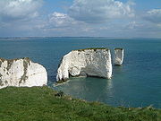
- Old Harry RocksOld Harry RocksThe Old Harry Rocks are two chalk sea stacks located at Handfast Point, on the Isle of Purbeck in Dorset, southern England.- Location :Old Harry Rocks lie directly east of Studland, about 4 kilometres northeast of Swanage, and about 10 kilometres south of the large towns of Poole and...
See also
- Purbeck HillsPurbeck HillsThe Purbeck Hills and South Dorset Downs are a ridge of chalk downs in Dorset, England. The hills extend from the Dorset Downs west of Dorchester, where the River Frome begins to form a valley dividing them from the larger area of downland to the north. The ridge then runs east through the Isle...
- Isle of PurbeckIsle of PurbeckThe Isle of Purbeck, not a true island but a peninsula, is in the county of Dorset, England. It is bordered by the English Channel to the south and east, where steep cliffs fall to the sea; and by the marshy lands of the River Frome and Poole Harbour to the north. Its western boundary is less well...
- Geology of DorsetGeology of DorsetDorset, England, rests on a variety of different rock types which give the county its interesting landscapes and habitats. Dorset is particularly noted for its coastline, the Jurassic Coast, which in 2001 was designated a World Heritage Site because of the variety of landforms and fossils...
- Geology of the United Kingdom
- List of fossil sites
- List of Dorset beaches
- South West Coast PathSouth West Coast PathThe South West Coast Path is Britain's longest waymarked long-distance footpath and a National Trail. It stretches for , running from Minehead in Somerset, along the coasts of Devon and Cornwall, to Poole Harbour in Dorset. Since it rises and falls with every river mouth, it is also one of the more...
- UK coastlineUK coastlineThe coastline of the United Kingdom is long in comparison to the coastline of similar sized countries; it is accessible and very varied in geography and habitats....