

Geology of Dorset
Encyclopedia
Dorset
Dorset , is a county in South West England on the English Channel coast. The county town is Dorchester which is situated in the south. The Hampshire towns of Bournemouth and Christchurch joined the county with the reorganisation of local government in 1974...
, England
England
England is a country that is part of the United Kingdom. It shares land borders with Scotland to the north and Wales to the west; the Irish Sea is to the north west, the Celtic Sea to the south west, with the North Sea to the east and the English Channel to the south separating it from continental...
, rests on a variety of different rock
Rock (geology)
In geology, rock or stone is a naturally occurring solid aggregate of minerals and/or mineraloids.The Earth's outer solid layer, the lithosphere, is made of rock. In general rocks are of three types, namely, igneous, sedimentary, and metamorphic...
types which give the county its interesting landscapes and habitats
Habitat (ecology)
A habitat is an ecological or environmental area that is inhabited by a particular species of animal, plant or other type of organism...
. Dorset is particularly noted for its coast
Coast
A coastline or seashore is the area where land meets the sea or ocean. A precise line that can be called a coastline cannot be determined due to the dynamic nature of tides. The term "coastal zone" can be used instead, which is a spatial zone where interaction of the sea and land processes occurs...
line, the Jurassic Coast
Jurassic Coast
The Jurassic Coast is a World Heritage Site on the English Channel coast of southern England. The site stretches from Orcombe Point near Exmouth in East Devon to Old Harry Rocks near Swanage in East Dorset, a distance of ....
, which in 2001 was designated a World Heritage Site
World Heritage Site
A UNESCO World Heritage Site is a place that is listed by the UNESCO as of special cultural or physical significance...
because of the variety of landform
Landform
A landform or physical feature in the earth sciences and geology sub-fields, comprises a geomorphological unit, and is largely defined by its surface form and location in the landscape, as part of the terrain, and as such, is typically an element of topography...
s and fossil
Fossil
Fossils are the preserved remains or traces of animals , plants, and other organisms from the remote past...
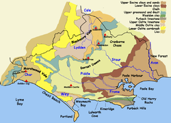
s exhibited along the coast. 44% of the county is within the Dorset AONB, which includes most of the Downs, Blackmore Vale, Purbecks, the Chesil Beach and Fleet SSSI and Poole Harbour.
Downland
Limestone
Limestone is a sedimentary rock composed largely of the minerals calcite and aragonite, which are different crystal forms of calcium carbonate . Many limestones are composed from skeletal fragments of marine organisms such as coral or foraminifera....
ridges. These ridges support arable
Arable land
In geography and agriculture, arable land is land that can be used for growing crops. It includes all land under temporary crops , temporary meadows for mowing or pasture, land under market and kitchen gardens and land temporarily fallow...
agriculture
Agriculture
Agriculture is the cultivation of animals, plants, fungi and other life forms for food, fiber, and other products used to sustain life. Agriculture was the key implement in the rise of sedentary human civilization, whereby farming of domesticated species created food surpluses that nurtured the...
and calcareous grassland
Calcareous grassland
Calcareous grassland is an ecosystem associated with thin basic soil, such as that on chalk and limestone downland. Plants on calcareous grassland are typically short and hardy, and include grasses and herbs such as clover...
habitats, as well as aquifer
Aquifer
An aquifer is a wet underground layer of water-bearing permeable rock or unconsolidated materials from which groundwater can be usefully extracted using a water well. The study of water flow in aquifers and the characterization of aquifers is called hydrogeology...
s. The largest and most notable of the limestone bands is the band of Cretaceous
Cretaceous
The Cretaceous , derived from the Latin "creta" , usually abbreviated K for its German translation Kreide , is a geologic period and system from circa to million years ago. In the geologic timescale, the Cretaceous follows the Jurassic period and is followed by the Paleogene period of the...
chalk
Chalk
Chalk is a soft, white, porous sedimentary rock, a form of limestone composed of the mineral calcite. Calcite is calcium carbonate or CaCO3. It forms under reasonably deep marine conditions from the gradual accumulation of minute calcite plates shed from micro-organisms called coccolithophores....
which runs from the south west to the north east of the county and forms part of the Southern England Chalk Formation
Southern England Chalk Formation
The Chalk Formation of Southern England is a system of chalk downland in the south of England. The formation is perhaps best known for Salisbury Plain, the location of Stonehenge, the Isle of Wight and the twin ridgeways of the North Downs and South Downs....
which underlies much of south of England, including Salisbury Plain
Salisbury Plain
Salisbury Plain is a chalk plateau in central southern England covering . It is part of the Southern England Chalk Formation and largely lies within the county of Wiltshire, with a little in Hampshire. The plain is famous for its rich archaeology, including Stonehenge, one of England's best known...
, the Isle of Wight
Isle of Wight
The Isle of Wight is a county and the largest island of England, located in the English Channel, on average about 2–4 miles off the south coast of the county of Hampshire, separated from the mainland by a strait called the Solent...
and the South Downs
South Downs
The South Downs is a range of chalk hills that extends for about across the south-eastern coastal counties of England from the Itchen Valley of Hampshire in the west to Beachy Head, near Eastbourne, East Sussex, in the east. It is bounded on its northern side by a steep escarpment, from whose...
. The central Dorset section of the chalk formation is known as the Dorset Downs
Dorset Downs
The Dorset Downs are an area of Chalk downland in the centre of the county Dorset in south west England. The downs are the most western part of a larger Chalk Formation which also includes Cranborne Chase, Salisbury Plain, Hampshire Downs, Chiltern Hills, North Downs and South Downs.The Dorset...
, and the north eastern section, which runs into Wiltshire
Wiltshire
Wiltshire is a ceremonial county in South West England. It is landlocked and borders the counties of Dorset, Somerset, Hampshire, Gloucestershire, Oxfordshire and Berkshire. It contains the unitary authority of Swindon and covers...
, as Cranborne Chase
Cranborne Chase
Cranborne Chase is a Chalk plateau in central southern England, straddling the counties Dorset, Hampshire and Wiltshire. The plateau is part of the English Chalk Formation and is adjacent to Salisbury Plain and the West Wiltshire Downs in the north, the Dorset Downs to the south west and the...
. The two are separated by the Stour Valley
River Stour, Dorset
The River Stour is a 60.5 mile long river which flows through Wiltshire and Dorset in southern England, and drains into the English Channel. It is sometimes called the Dorset Stour to distinguish it from rivers of the same name...
which cuts through the hills at Blandford Forum. In the Isle of Purbeck
Isle of Purbeck
The Isle of Purbeck, not a true island but a peninsula, is in the county of Dorset, England. It is bordered by the English Channel to the south and east, where steep cliffs fall to the sea; and by the marshy lands of the River Frome and Poole Harbour to the north. Its western boundary is less well...
is another, smaller, ridge of the chalk formation, known as the Purbeck Hills
Purbeck Hills
The Purbeck Hills and South Dorset Downs are a ridge of chalk downs in Dorset, England. The hills extend from the Dorset Downs west of Dorchester, where the River Frome begins to form a valley dividing them from the larger area of downland to the north. The ridge then runs east through the Isle...
.
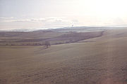
The high chalk hills were important in the pre-Roman
Roman Britain
Roman Britain was the part of the island of Great Britain controlled by the Roman Empire from AD 43 until ca. AD 410.The Romans referred to the imperial province as Britannia, which eventually comprised all of the island of Great Britain south of the fluid frontier with Caledonia...
history of Dorset
History of Dorset
Dorset is a rural county in south west England. Its archaeology documents much of the history of southern England.-Pre-Roman:The first known settlement of Dorset was by Mesolithic hunters, who returned to Britain at a time when it was still attached to Europe by a land-bridge, around 12,500 BC...
, the location of settlements in the Neolithic
Neolithic
The Neolithic Age, Era, or Period, or New Stone Age, was a period in the development of human technology, beginning about 9500 BC in some parts of the Middle East, and later in other parts of the world. It is traditionally considered as the last part of the Stone Age...
, Bronze Age
Bronze Age
The Bronze Age is a period characterized by the use of copper and its alloy bronze as the chief hard materials in the manufacture of some implements and weapons. Chronologically, it stands between the Stone Age and Iron Age...
and Iron Age
Iron Age
The Iron Age is the archaeological period generally occurring after the Bronze Age, marked by the prevalent use of iron. The early period of the age is characterized by the widespread use of iron or steel. The adoption of such material coincided with other changes in society, including differing...
, and are noted for the hill fort
Hill fort
A hill fort is a type of earthworks used as a fortified refuge or defended settlement, located to exploit a rise in elevation for defensive advantage. They are typically European and of the Bronze and Iron Ages. Some were used in the post-Roman period...
s at Maiden Castle
Maiden Castle, Dorset
Maiden Castle is an Iron Age hill fort south west of Dorchester, in the English county of Dorset. Hill forts were fortified hill-top settlements constructed across Britain during the Iron Age...
, Hambledon Hill
Hambledon Hill
Hambledon Hill is a prehistoric hill fort in Dorset, England, situated in the Blackmore Vale five miles north of Blandford Forum. The hill is a Chalk outcrop, on the south western corner of Cranborne Chase, separated from the Dorset Downs by the River Stour....
and Badbury Rings
Badbury Rings
Badbury Rings is an Iron Age hill fort in east Dorset, England, dating from 800 BC and in use until the Roman occupation of 43 AD.-Iron Age:...
and for the Cerne Abbas giant
Cerne Abbas giant
The Cerne Abbas Giant, also referred to as the Rude Man or the Rude Giant, is a hill figure of a giant naked man on a hillside near the village of Cerne Abbas, to the north of Dorchester, in Dorset, England. The high, wide figure is carved into the side of a steep hill, and is best viewed from...
chalk hill figure. Running through the chalk hills are a number of winterbourne
Winterbourne (stream)
A winterbourne is a stream or river that is dry through the summer months. A winterbourne is sometimes simply called a bourne, from the Anglo-Saxon for a stream flowing from a spring, although this term can also be used for all-year water courses....
valleys.
Valleys
Tertiary
The Tertiary is a deprecated term for a geologic period 65 million to 2.6 million years ago. The Tertiary covered the time span between the superseded Secondary period and the Quaternary...
clay
Clay
Clay is a general term including many combinations of one or more clay minerals with traces of metal oxides and organic matter. Geologic clay deposits are mostly composed of phyllosilicate minerals containing variable amounts of water trapped in the mineral structure.- Formation :Clay minerals...
vale
River Valley
River Valley is the name of an urban planning area within the Central Area, Singapore's central business district.The River Valley Planning Area is defined by the region bounded by Orchard Boulevard, Devonshire Road and Eber Road to the north, Oxley Rise and Mohamed Sultan Road to the east, Martin...
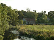
s with large flood plains, which sustain many small settlements and dairy
Dairy
A dairy is a business enterprise established for the harvesting of animal milk—mostly from cows or goats, but also from buffalo, sheep, horses or camels —for human consumption. A dairy is typically located on a dedicated dairy farm or section of a multi-purpose farm that is concerned...
farms. The most notable of the valleys are those of the Stour
River Stour, Dorset
The River Stour is a 60.5 mile long river which flows through Wiltshire and Dorset in southern England, and drains into the English Channel. It is sometimes called the Dorset Stour to distinguish it from rivers of the same name...
and Frome
River Frome, Dorset
The River Frome is a river in Dorset in the south of England. At 30 miles long it is the major chalkstream in southwest England. It is navigable upstream from Poole Harbour as far as the town of Wareham.-Geography:...
. The Stour flows into the north of the county at Gillingham
Gillingham, Dorset
Gillingham is a town in the Blackmore Vale area of Dorset, England. The town is the most northerly in the county. It is 3 miles south of the A303 lying on the B3092 and B3081. It is near to the town of Shaftesbury which lies 7 miles to the south east. Neighbouring hamlets included Peacemarsh, Bay...
, into a wide basin
Drainage basin
A drainage basin is an extent or an area of land where surface water from rain and melting snow or ice converges to a single point, usually the exit of the basin, where the waters join another waterbody, such as a river, lake, reservoir, estuary, wetland, sea, or ocean...
, the Blackmore Vale
Blackmore Vale
The Blackmore Vale is a vale, or wide valley, in north Dorset, and to a lesser extent south Somerset and southwest Wiltshire in southern England. The vale is part of the Stour valley...
, where it collects from many small tributaries. The river then flows south, through a gap in the chalk and across the healthand of south east Dorset. The Frome collects water from the aquifer of the Dorset Downs, forming in the hills in west Dorset
West Dorset
West Dorset is a local government district and parliamentary constituency in Dorset, England. Its council is based in Dorchester. The district was formed on 1 April 1974, under the Local Government Act 1972, and was a merger of the boroughs of Bridport, Dorchester and Lyme Regis, along with...
, and flowing through Dorchester into a wide estuary
Estuary
An estuary is a partly enclosed coastal body of water with one or more rivers or streams flowing into it, and with a free connection to the open sea....
, Poole Harbour
Poole Harbour
Poole Harbour is a large natural harbour in Dorset, southern England, with the town of Poole on its shores. The harbour is a drowned valley formed at the end of the last ice age and is the estuary of several rivers, the largest being the Frome. The harbour has a long history of human settlement...
, where it reaches the weak sand
Sand
Sand is a naturally occurring granular material composed of finely divided rock and mineral particles.The composition of sand is highly variable, depending on the local rock sources and conditions, but the most common constituent of sand in inland continental settings and non-tropical coastal...
s in the south east of the county.
Heathland
South-east Dorset, around PoolePoole
Poole is a large coastal town and seaport in the county of Dorset, on the south coast of England. The town is east of Dorchester, and Bournemouth adjoins Poole to the east. The Borough of Poole was made a unitary authority in 1997, gaining administrative independence from Dorset County Council...
and Bournemouth
Bournemouth
Bournemouth is a large coastal resort town in the ceremonial county of Dorset, England. According to the 2001 Census the town has a population of 163,444, making it the largest settlement in Dorset. It is also the largest settlement between Southampton and Plymouth...
, and the New Forest
New Forest
The New Forest is an area of southern England which includes the largest remaining tracts of unenclosed pasture land, heathland and forest in the heavily-populated south east of England. It covers south-west Hampshire and extends into south-east Wiltshire....
, lie on very unresistant Tertiary
Tertiary
The Tertiary is a deprecated term for a geologic period 65 million to 2.6 million years ago. The Tertiary covered the time span between the superseded Secondary period and the Quaternary...
beds: Eocene
Eocene
The Eocene Epoch, lasting from about 56 to 34 million years ago , is a major division of the geologic timescale and the second epoch of the Paleogene Period in the Cenozoic Era. The Eocene spans the time from the end of the Palaeocene Epoch to the beginning of the Oligocene Epoch. The start of the...
clays (mainly London Clay
London Clay
The London Clay Formation is a marine geological formation of Ypresian age which crops out in the southeast of England. The London Clay is well known for the fossils it contains. The fossils from the Lower Eocene indicate a moderately warm climate, the flora being tropical or subtropical...
and Gault Clay
Gault Clay
Gault is a clay formation of stiff blue clay deposited in a calm, fairly deep water marine environment during the Lower Cretaceous Period...
), sand
Sand
Sand is a naturally occurring granular material composed of finely divided rock and mineral particles.The composition of sand is highly variable, depending on the local rock sources and conditions, but the most common constituent of sand in inland continental settings and non-tropical coastal...
s and gravel
Gravel
Gravel is composed of unconsolidated rock fragments that have a general particle size range and include size classes from granule- to boulder-sized fragments. Gravel can be sub-categorized into granule and cobble...
s. These thin soils support a heathland habitat which supports all six native British reptile
Reptile
Reptiles are members of a class of air-breathing, ectothermic vertebrates which are characterized by laying shelled eggs , and having skin covered in scales and/or scutes. They are tetrapods, either having four limbs or being descended from four-limbed ancestors...
species. Dorset Heath, a species of the genus Erica
Erica
Erica ,the heaths or heathers, is a genus of approximately 860 species of flowering plants in the family Ericaceae. The English common names "heath" and "heather" are shared by some closely related genera of similar appearance....
, grows in this area, and in 2002 was chosen as a symbol of the county by Plantlife
Plantlife
Plantlife is a wild plant conservation charity. As of 2007, its membership was 10,500 and it owned 23 nature reserves around the UK.-History:It was founded in 1989 with its first President being Professor David Bellamy. By 1999 it had 22 nature reserves....
's "county flower" competition.
The River Frome
River Frome, Dorset
The River Frome is a river in Dorset in the south of England. At 30 miles long it is the major chalkstream in southwest England. It is navigable upstream from Poole Harbour as far as the town of Wareham.-Geography:...
estuary
Estuary
An estuary is a partly enclosed coastal body of water with one or more rivers or streams flowing into it, and with a free connection to the open sea....
runs through this weak rock, and its many tributaries
Tributary
A tributary or affluent is a stream or river that flows into a main stem river or a lake. A tributary does not flow directly into a sea or ocean...
have carved out a very wide estuary
Estuary
An estuary is a partly enclosed coastal body of water with one or more rivers or streams flowing into it, and with a free connection to the open sea....
. At the mouth of the estuary sand spits
Spit (landform)
A spit or sandspit is a deposition landform found off coasts. At one end, spits connect to land, and extend into the sea. A spit is a type of bar or beach that develops where a re-entrant occurs, such as at cove's headlands, by the process of longshore drift...
have been deposited turning the estuary into Poole Harbour
Poole Harbour
Poole Harbour is a large natural harbour in Dorset, southern England, with the town of Poole on its shores. The harbour is a drowned valley formed at the end of the last ice age and is the estuary of several rivers, the largest being the Frome. The harbour has a long history of human settlement...
, the second largest natural harbour in the world (after Sydney Harbour
Port Jackson
Port Jackson, containing Sydney Harbour, is the natural harbour of Sydney, Australia. It is known for its beauty, and in particular, as the location of the Sydney Opera House and Sydney Harbour Bridge...
, though since artificial expansion Sydney's claim is disputed). The harbour is very shallow in places and contains a number of islands, notably Brownsea Island
Brownsea Island
Brownsea Island is the largest of the islands in Poole Harbour in the county of Dorset, England. The island is owned by the National Trust. Much of the island is open to the public and includes areas of woodland and heath with a wide variety of wildlife, together with cliff top views across Poole...
, famous for its Red Squirrel
Red Squirrel
The red squirrel or Eurasian red squirrel is a species of tree squirrel in the genus Sciurus common throughout Eurasia...
sanctuary and as the birthplace of the Scouting
Scouting
Scouting, also known as the Scout Movement, is a worldwide youth movement with the stated aim of supporting young people in their physical, mental and spiritual development, that they may play constructive roles in society....
movement.
The harbour, and the chalk and limestone hills of the Purbeck
Isle of Purbeck
The Isle of Purbeck, not a true island but a peninsula, is in the county of Dorset, England. It is bordered by the English Channel to the south and east, where steep cliffs fall to the sea; and by the marshy lands of the River Frome and Poole Harbour to the north. Its western boundary is less well...
s to the south, lie atop Britain's largest onshore oil field
Oil field
An oil field is a region with an abundance of oil wells extracting petroleum from below ground. Because the oil reservoirs typically extend over a large area, possibly several hundred kilometres across, full exploitation entails multiple wells scattered across the area...
. The field, operated by BP
BP
BP p.l.c. is a global oil and gas company headquartered in London, United Kingdom. It is the third-largest energy company and fourth-largest company in the world measured by revenues and one of the six oil and gas "supermajors"...
from Wytch Farm
Wytch Farm
Wytch Farm is an oil field and processing facility in the Purbeck district of Dorset, England. It is the largest onshore oil field in western Europe. The facility, operated by BP, is hidden in a coniferous forest on Wytch Heath on the southern shore of Poole Harbour, two miles north of Corfe Castle...
, produces a high-quality oil and has the world's oldest continuously pumping well (Kimmeridge
Kimmeridge
Kimmeridge is a small village in the Purbeck district of Dorset, England, situated on the English Channel coast. Kimmeridge is about south of Wareham and about west of Swanage and is on the Isle of Purbeck...
, since the early 1960s) and longest horizontal drill (5 miles, ending underneath Bournemouth pier
Pier
A pier is a raised structure, including bridge and building supports and walkways, over water, typically supported by widely spread piles or pillars...
). The clay pottery
Pottery
Pottery is the material from which the potteryware is made, of which major types include earthenware, stoneware and porcelain. The place where such wares are made is also called a pottery . Pottery also refers to the art or craft of the potter or the manufacture of pottery...
produced by Poole pottery
Poole Pottery
Poole Pottery is a pottery manufacturer, originally based in Poole, Dorset, England. The company was founded in 1873 on Poole quayside, where it continued to produce pottery by hand before moving its factory operations away from the quay in 1999. Production continued at the new site in Sopers Lane...
from the local clays is famous for its quality.
Coastline
Dorset's coastline is one of the most visited and studied coastlines in the world because it shows, along the course of 95 miles (153 km) (including some of east DevonDevon
Devon is a large county in southwestern England. The county is sometimes referred to as Devonshire, although the term is rarely used inside the county itself as the county has never been officially "shired", it often indicates a traditional or historical context.The county shares borders with...
) rocks from the beginning of Triassic
Triassic
The Triassic is a geologic period and system that extends from about 250 to 200 Mya . As the first period of the Mesozoic Era, the Triassic follows the Permian and is followed by the Jurassic. Both the start and end of the Triassic are marked by major extinction events...
, through the Jurassic
Jurassic
The Jurassic is a geologic period and system that extends from about Mya to Mya, that is, from the end of the Triassic to the beginning of the Cretaceous. The Jurassic constitutes the middle period of the Mesozoic era, also known as the age of reptiles. The start of the period is marked by...
and up to the end of the Cretaceous
Cretaceous
The Cretaceous , derived from the Latin "creta" , usually abbreviated K for its German translation Kreide , is a geologic period and system from circa to million years ago. In the geologic timescale, the Cretaceous follows the Jurassic period and is followed by the Paleogene period of the...
, documenting the entire Mesozoic
Mesozoic
The Mesozoic era is an interval of geological time from about 250 million years ago to about 65 million years ago. It is often referred to as the age of reptiles because reptiles, namely dinosaurs, were the dominant terrestrial and marine vertebrates of the time...
era with well preserved fossil
Fossil
Fossils are the preserved remains or traces of animals , plants, and other organisms from the remote past...
s. Particularly famous are the Triassic and Jurassic cliff
Cliff
In geography and geology, a cliff is a significant vertical, or near vertical, rock exposure. Cliffs are formed as erosion landforms due to the processes of erosion and weathering that produce them. Cliffs are common on coasts, in mountainous areas, escarpments and along rivers. Cliffs are usually...
s around Lyme Regis
Lyme Regis
Lyme Regis is a coastal town in West Dorset, England, situated 25 miles west of Dorchester and east of Exeter. The town lies in Lyme Bay, on the English Channel coast at the Dorset-Devon border...
which have yielded many notable fossil finds, including Mary Anning
Mary Anning
Mary Anning was a British fossil collector, dealer and palaeontologist who became known around the world for a number of important finds she made in the Jurassic age marine fossil beds at Lyme Regis where she lived...
's Ichthyosaur
Ichthyosaur
Ichthyosaurs were giant marine reptiles that resembled fish and dolphins...
. The variety of geology leads to a variety of habitats, from the heathland of the Tertiary beds at Poole Harbour and Studland
Studland
Studland is a small village on the Isle of Purbeck in the English county of Dorset. It is famous for its beaches and nature reserve. In 2001 Studland had a population of 480, the lowest in 50 years...
, to the Chalk downland where the Cretaceous beds reach the sea. There are also small areas of karst
KARST
Kilometer-square Area Radio Synthesis Telescope is a Chinese telescope project to which FAST is a forerunner. KARST is a set of large spherical reflectors on karst landforms, which are bowlshaped limestone sinkholes named after the Kras region in Slovenia and Northern Italy. It will consist of...
landscape on the Jurassic limestones.
What makes Dorset's coast particularly important to geologists though are the series of landform
Landform
A landform or physical feature in the earth sciences and geology sub-fields, comprises a geomorphological unit, and is largely defined by its surface form and location in the landscape, as part of the terrain, and as such, is typically an element of topography...
s which occur so close together, on the concordant
Concordant coastline
A concordant, longitudinal, or Pacific type coastline occurs where beds, or layers, of differing rock types are folded into ridges that run parallel to the coast. The outer hard rock provides a protective barrier to erosion of the softer rocks further inland...
and discordant coastline
Discordant coastline
A discordant coastline occurs where bands of differing rock type run perpendicular to the coast.The differing resistance to erosion leads to the formation of headlands and bays...
s. The most famous include Lulworth Cove
Lulworth Cove
Lulworth Cove is a cove near the village of West Lulworth, on the Jurassic Coast World Heritage Site in Dorset, southern England. The cove is one of the world's finest examples of such a landform, and is a tourist location with over 1 million visitors a year...
, Durdle Door
Durdle Door
Durdle Door is a natural limestone arch on the Jurassic Coast near Lulworth in Dorset, England. It is privately owned by the Welds, a family who own in Dorset in the name of the Lulworth Estate. It is open to the public...
natural arch
Natural arch
A natural arch or natural bridge is a natural geological formation where a rock arch forms, with an opening underneath. Most natural arches form as a narrow ridge, walled by cliffs, become narrower from erosion, with a softer rock stratum under the cliff-forming stratum gradually eroding out until...
, Old Harry Rocks
Old Harry Rocks
The Old Harry Rocks are two chalk sea stacks located at Handfast Point, on the Isle of Purbeck in Dorset, southern England.- Location :Old Harry Rocks lie directly east of Studland, about 4 kilometres northeast of Swanage, and about 10 kilometres south of the large towns of Poole and...
and Chesil Beach
Chesil Beach
Chesil Beach, sometimes called Chesil Bank, in Dorset, southern England is one of three major shingle structures in Britain. Its toponym is derived from the Old English ceosel or cisel, meaning "gravel" or "shingle"....
, a tombolo
Tombolo
A tombolo, from the Italian tombolo, derived from the Latin tumulus, meaning 'mound,' and sometimes translated as ayre , is a deposition landform in which an island is attached to the mainland by a narrow piece of land such as a spit or bar. Once attached, the island is then known as a tied island...
. The Portland limestone of the Isle of Portland
Isle of Portland
The Isle of Portland is a limestone tied island, long by wide, in the English Channel. Portland is south of the resort of Weymouth, forming the southernmost point of the county of Dorset, England. A tombolo over which runs the A354 road connects it to Chesil Beach and the mainland. Portland and...
and the Purbeck Limestone
Purbeck Marble
Purbeck Marble is a fossiliferous limestone quarried in the Isle of Purbeck, a peninsula in south-east Dorset, England.It is one of many kinds of Purbeck Limestone, deposited in the late Jurassic or early Cretaceous periods....
of the Isle of Purbeck
Isle of Purbeck
The Isle of Purbeck, not a true island but a peninsula, is in the county of Dorset, England. It is bordered by the English Channel to the south and east, where steep cliffs fall to the sea; and by the marshy lands of the River Frome and Poole Harbour to the north. Its western boundary is less well...
have been quarried for use in building much of London
London
London is the capital city of :England and the :United Kingdom, the largest metropolitan area in the United Kingdom, and the largest urban zone in the European Union by most measures. Located on the River Thames, London has been a major settlement for two millennia, its history going back to its...
and hundreds of thousands of British war grave stones and memorials.
See also
- Geology of EnglandGeology of EnglandThe Geology of England is mainly sedimentary. The youngest rocks are in the south east around London, progressing in age in a north westerly direction. The Tees-Exe line marks the division between younger, softer and low-lying rocks in the south east and older, harder, and generally a higher relief...
- Geology of the United Kingdom
- List of Dorset beaches
- List of places on the Jurassic Coast