

List of megalithic monuments in Ireland
Encyclopedia
This is a list of megalithic monuments
on the island of Ireland
.
Megalith
A megalith is a large stone that has been used to construct a structure or monument, either alone or together with other stones. Megalithic describes structures made of such large stones, utilizing an interlocking system without the use of mortar or cement.The word 'megalith' comes from the Ancient...
on the island of Ireland
Ireland
Ireland is an island to the northwest of continental Europe. It is the third-largest island in Europe and the twentieth-largest island on Earth...
.
| Photograph | Name | County | Coordinates | Type | Age |
|---|---|---|---|---|---|
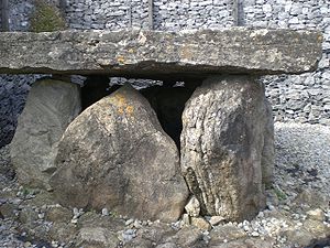
| Annadorn Dolmen Annadorn Dolmen Annadorn Dolmen is a dolmen sited at the Buck's Head near Loughinisland, County Down, Northern Ireland. It is on the north-east shore of Loughinisland Lake, on a hillock overlooking Loughinisland Churches, a group of three ruined churches. The site is a State Care Historic Monument at grid ref:... |
Down County Down -Cities:*Belfast *Newry -Large towns:*Dundonald*Newtownards*Bangor-Medium towns:... |
54°20′31.75"N 5°48′12.52"W | portal tomb | - | |
.jpg) |
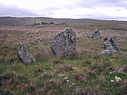
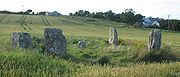
Ardgroom Ardgroom Ardgroom is a village on the Beara peninsula in County Cork, Ireland. Its name refers to two gravelly hills deposited by a glacier, Dromárd and Drombeg. It lies to the northwest of Glenbeg Lough, overlooking the Kenmare River estuary. It sits between the coast and the Slieve Miskish Mountains. The... |
Cork County Cork County Cork is a county in Ireland. It is located in the South-West Region and is also part of the province of Munster. It is named after the city of Cork . Cork County Council is the local authority for the county... |
51°44′23.23"N 9°53′37.9"W | stone circle Stone circle A stone circle is a monument of standing stones arranged in a circle. Such monuments have been constructed across the world throughout history for many different reasons.... |
- |
| Audleystown Court Tomb Audleystown Court Cairn Audleystown Court Cairn is a dual court grave situated near the south shore of Strangford Lough, north-west of Castle Ward, 1.75 miles from Strangford village in County Down, Northern Ireland, at grid ref: 562 504)... |
Down County Down -Cities:*Belfast *Newry -Large towns:*Dundonald*Newtownards*Bangor-Medium towns:... |
54°22′29.13"N 5°35′58.08"W | court tomb | - | |
 |
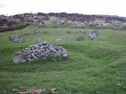
Aughlish Aughlish Aughlish is the site of at least six stone circles and two stone rows, in County Londonderry, Northern Ireland, 3.6km from Feeny.-Features:... |
Londonderry County Londonderry The place name Derry is an anglicisation of the old Irish Daire meaning oak-grove or oak-wood. As with the city, its name is subject to the Derry/Londonderry name dispute, with the form Derry preferred by nationalists and Londonderry preferred by unionists... |
54.896°N 7.041°W | stone circle Stone circle A stone circle is a monument of standing stones arranged in a circle. Such monuments have been constructed across the world throughout history for many different reasons.... s |
- |
| - | Ballinran Court Tomb Ballinran Court Tomb Ballinran Court Tomb is situated close to Killowen, County Down, Northern Ireland, on the shore of Carlingford Lough.... |
Down County Down -Cities:*Belfast *Newry -Large towns:*Dundonald*Newtownards*Bangor-Medium towns:... |
- | court tomb | - |
| - | Ballyalton Court Tomb Ballyalton Court Cairn Ballyalton Court Cairn is a single court grave situated on a rock outcrop by the roadside 0.5 miles from Ballyalton village, which is 2.25 miles east of Downpatrick, County Down, Northern Ireland, at grid ref 531 448. The tomb contained human bones, flint implements and pottery now known as... |
Down County Down -Cities:*Belfast *Newry -Large towns:*Dundonald*Newtownards*Bangor-Medium towns:... |
54.3288°N 5.6463°W | court tomb | - |
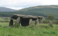
| Ballykeel Dolmen Ballykeel Dolmen Ballykeel Dolmen is a neolithic tripod portal tomb and a State Care Historic Monument at the foot of the western flank of Slieve Gullion, above a tributary of the Forkhill river, in the Newry and Mourne District Council area, at grid ref: H9950 2132.... |
Armagh County Armagh -History:Ancient Armagh was the territory of the Ulaid before the fourth century AD. It was ruled by the Red Branch, whose capital was Emain Macha near Armagh. The site, and subsequently the city, were named after the goddess Macha... |
54.136696°N 6.471204°W | ortal tomb] | - | |
jul2007.jpg) |
Ballylumford Dolmen Ballylumford Dolmen Ballylumford Dolmen is situated on Islandmagee, County Antrim, Northern Ireland, near the north-west tip of the Islandmagee peninsula and near Ballylumford power station. It is known locally as the "Druid's Altar", and could be 4000 years old, or the remains of an even earlier passage grave... |
Antrim County Antrim County Antrim is one of six counties that form Northern Ireland, situated in the north-east of the island of Ireland. Adjoined to the north-east shore of Lough Neagh, the county covers an area of 2,844 km², with a population of approximately 616,000... |
54°50′30"N 5°46′26"W | portal tomb | 4000 years |
jun2008.jpg) |
Ballymacaldrack Court Tomb | Antrim County Antrim County Antrim is one of six counties that form Northern Ireland, situated in the north-east of the island of Ireland. Adjoined to the north-east shore of Lough Neagh, the county covers an area of 2,844 km², with a population of approximately 616,000... |
55°0′5.9"N 6°24′15.3"W | court tomb | - |
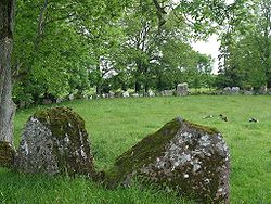
| Ballynoe Stone Circle Ballynoe Stone Circle Ballynoe Stone Circle is a stone circle situated in the small hamlet of Ballynoe 2.5 miles south of Downpatrick, County Down, Northern Ireland. It is near the disused railway station, reached by a long footpath off the main road, at grid ref: J481404... |
Down County Down -Cities:*Belfast *Newry -Large towns:*Dundonald*Newtownards*Bangor-Medium towns:... |
54.290937°N 5.726292°W | stone circle Stone circle A stone circle is a monument of standing stones arranged in a circle. Such monuments have been constructed across the world throughout history for many different reasons.... |
- | |
 |
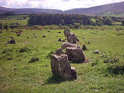
Beaghmore Beaghmore Beaghmore is a complex of early Bronze Age megalithic features, stone circles and cairns, 8.5 miles north west of Cookstown, County Tyrone in Northern Ireland, on the south-east edge of the Sperrin Mountains... |
Tyrone County Tyrone Historically Tyrone stretched as far north as Lough Foyle, and comprised part of modern day County Londonderry east of the River Foyle. The majority of County Londonderry was carved out of Tyrone between 1610-1620 when that land went to the Guilds of London to set up profit making schemes based on... |
54°42′14"N 6°56′11"W | stone circle Stone circle A stone circle is a monument of standing stones arranged in a circle. Such monuments have been constructed across the world throughout history for many different reasons.... s, cairn Cairn Cairn is a term used mainly in the English-speaking world for a man-made pile of stones. It comes from the or . Cairns are found all over the world in uplands, on moorland, on mountaintops, near waterways and on sea cliffs, and also in barren desert and tundra areas... s |
- |
| - | Beenalaght Beenalaght Beenalaght is an alignment of six standing stones located on a flat pasture in Reanthesure, 0.5km west of the village of Bweeng, County Cork, Ireland. It is 13.6km south-west of Mallow, on a hill to the west of the Mallow-Coachford Road... |
Cork County Cork County Cork is a county in Ireland. It is located in the South-West Region and is also part of the province of Munster. It is named after the city of Cork . Cork County Council is the local authority for the county... |
- | stone row Stone row A stone row , is a linear arrangement of upright, parallel megalithic standing stones set at intervals along a common axis or series of axes, usually dating from the later Neolithic or Bronze Age. Rows may be individual or grouped, and three or more stones aligned can constitute a stone row... |
- |
| Beltany stone circle | Donegal County Donegal County Donegal is a county in Ireland. It is part of the Border Region and is also located in the province of Ulster. It is named after the town of Donegal. Donegal County Council is the local authority for the county... |
54°51.025′N 7°36.28′W | stone circle Stone circle A stone circle is a monument of standing stones arranged in a circle. Such monuments have been constructed across the world throughout history for many different reasons.... |
- | |
| - | Bohonagh Bohonagh Bohonagh is a recumbent stone circle located 2.4 km east of Rosscarbery, County Cork, Ireland. The circle is thought to date from the Bronze Age. A boulder burial is sited nearby .-Features:... |
Cork County Cork County Cork is a county in Ireland. It is located in the South-West Region and is also part of the province of Munster. It is named after the city of Cork . Cork County Council is the local authority for the county... |
51.580102°N 8.998987°W | stone circle Stone circle A stone circle is a monument of standing stones arranged in a circle. Such monuments have been constructed across the world throughout history for many different reasons.... |
- |
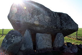 |
Brownshill Dolmen Brownshill Dolmen The Brownshill Dolmen is a megalithic portal tomb situated 3 km east of Carlow, in County Carlow, Ireland. It lies just off the R726 regional road and is clearly visible from the road. The capstone at Brownshill, weighing an estimated 100 metric tons, is reputed to be the heaviest in Europe... |
Carlow County Carlow County Carlow is a county in Ireland. It is part of the South-East Region and is also located in the province of Leinster. It is named after the town of Carlow, which lies on the River Barrow. Carlow County Council is the local authority for the county... |
- | portal tomb | 5000–6000 years |
 |
Carrigagulla Carrigagulla Carrigagulla is a megalithic complex located 2.9 km north-east of Ballinagree, County Cork, Ireland. It comprises two recumbent stone circles, two stone rows, and an ogham stone which has been moved around a half mile away.... |
Cork County Cork County Cork is a county in Ireland. It is located in the South-West Region and is also part of the province of Munster. It is named after the city of Cork . Cork County Council is the local authority for the county... |
- | stone circle Stone circle A stone circle is a monument of standing stones arranged in a circle. Such monuments have been constructed across the world throughout history for many different reasons.... s, stone row Stone row A stone row , is a linear arrangement of upright, parallel megalithic standing stones set at intervals along a common axis or series of axes, usually dating from the later Neolithic or Bronze Age. Rows may be individual or grouped, and three or more stones aligned can constitute a stone row... s |
- |
| Carrowkeel Tombs Carrowkeel Megalithic Cemetery Carrowkeel is a Neolithic passage tomb cemetery in the south of County Sligo, near Boyle, County Roscommon. An Cheathrú Chaol in Irish means 'the Narrow Quarter'. Circumstantial Carbon 14 dating places the tombs at between 5400 and 5100 years old, so that they predate the Pyramids on Egypt's Giza... |
Sligo | 54°03′12"N 8°22′40"W | passage tombs | 5100–5400 years | |
| Carrowmore Carrowmore Carrowmore, County Sligo is one of the four major passage tomb cemeteries in Ireland. It is located at the centre of a prehistoric ritual landscape on the Cúil Irra Peninsula in County Sligo in Ireland.... |
Sligo | 54°15′03.08"N 8°31′09.00"W | various | - | |
 |
Castlestrange stone Castlestrange stone The Castlestrange stone is located in the grounds of "Castlestrange House" near Athleague in County Roscommon. It is a granite boulder decorated with flowing spirals in the La Tène style, dating from the Iron Age period between 500 BC and 100 AD.... |
Roscommon County Roscommon County Roscommon is a county in Ireland. It is located in the West Region and is also part of the province of Connacht. It is named after the town of Roscommon. Roscommon County Council is the local authority for the county... |
- | standing stone Standing stone Standing stones, orthostats, liths, or more commonly megaliths are solitary stones set vertically in the ground and come in many different varieties.... |
- |
 |
Cloghanmore Cloghanmore Cloghanmore is a megalithic chamber tomb of the court tomb type located about 8 km east from Carrick in Malin More, Glencolmcille, in County Donegal, Ireland.-Features:... |
Donegal County Donegal County Donegal is a county in Ireland. It is part of the Border Region and is also located in the province of Ulster. It is named after the town of Donegal. Donegal County Council is the local authority for the county... |
- | court tomb | - |
 |
Corick Corick Corick is a megalithic site in the civil parish of Ballynascreen, in Magherafelt District Council, County Londonderry, Northern Ireland. It includes a stone circle and a stone row. The Corick stone circles and alignments are located 2 km north east of Ballybriest court-tomb, 400 metres south of... |
Londonderry County Londonderry The place name Derry is an anglicisation of the old Irish Daire meaning oak-grove or oak-wood. As with the city, its name is subject to the Derry/Londonderry name dispute, with the form Derry preferred by nationalists and Londonderry preferred by unionists... |
54.748°N 6.791°W | stone circle Stone circle A stone circle is a monument of standing stones arranged in a circle. Such monuments have been constructed across the world throughout history for many different reasons.... s |
- |
| - | Craigs Dolmen Craigs Dolmen Craigs Dolmen is situated three miles north of Rasharkin, County Antrim, Northern Ireland, close to a minor road, at a height of 200m on the Long Mountain... |
Antrim County Antrim County Antrim is one of six counties that form Northern Ireland, situated in the north-east of the island of Ireland. Adjoined to the north-east shore of Lough Neagh, the county covers an area of 2,844 km², with a population of approximately 616,000... |
55°00′07"N 6°28′26"W | passage tomb | - |
| Dowth Dowth Dowth is a Neolithic passage tomb which stands in the Boyne Valley, County Meath, Ireland. It is found at .Dating from about 2,5002000 BCE, is the second oldest behind Newgrange of the three principal tombs of the Brú na Bóinne World Heritage Site a complex of passage-tombs... (part of Brú na Bóinne Brú na Bóinne is a World Heritage Site in County Meath, Ireland and is the largest and one of the most important prehistoric megalithic sites in Europe.-The site:... ) |
Meath County Meath County Meath is a county in Ireland. It is part of the Mid-East Region and is also located in the province of Leinster. It is named after the ancient Kingdom of Mide . Meath County Council is the local authority for the county... |
53°42′10.5"N 6°26′57"W | passage tomb | - | |
 |
Drombeg stone circle Drombeg stone circle Drombeg stone circle , is a Recumbent stone circle located east of Glandore, County Cork, Ireland. Drombeg is one of the most visited megalithic sites in Ireland... |
Cork County Cork County Cork is a county in Ireland. It is located in the South-West Region and is also part of the province of Munster. It is named after the city of Cork . Cork County Council is the local authority for the county... |
51.564553°N 9.08702°W | recumbent stone circle | |
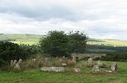
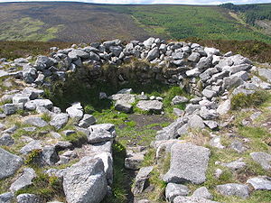
| Drumskinny Drumskinny Drumskinny is the site of a stone circle in the townland of Drumskinny, County Fermanagh, Northern Ireland. With the inclusion of an adjacent cairn and alignment, the stone circle is a State Care Historic Monument in Fermanagh District Council area, at grid ref: H 2009 7072... |
Fermanagh County Fermanagh Fermanagh District Council is the only one of the 26 district councils in Northern Ireland that contains all of the county it is named after. The district council also contains a small section of County Tyrone in the Dromore and Kilskeery road areas.... |
54.58443°N 7.69051°W | stone circle Stone circle A stone circle is a monument of standing stones arranged in a circle. Such monuments have been constructed across the world throughout history for many different reasons.... , cairn Cairn Cairn is a term used mainly in the English-speaking world for a man-made pile of stones. It comes from the or . Cairns are found all over the world in uplands, on moorland, on mountaintops, near waterways and on sea cliffs, and also in barren desert and tundra areas... |
- | |
| - | Eightercua Eightercua Eightercua is a four-stone alignment Megalithic tomb, located 1.5 km south-south-east of Waterville, County Kerry, Ireland. The tallest stone reaches 9 feet in height, and the alignment streaches for twenty five feet in an east-west direction... |
Kerry County Kerry Kerry means the "people of Ciar" which was the name of the pre-Gaelic tribe who lived in part of the present county. The legendary founder of the tribe was Ciar, son of Fergus mac Róich. In Old Irish "Ciar" meant black or dark brown, and the word continues in use in modern Irish as an adjective... |
51.81491°N 10.15807°W | stone row Stone row A stone row , is a linear arrangement of upright, parallel megalithic standing stones set at intervals along a common axis or series of axes, usually dating from the later Neolithic or Bronze Age. Rows may be individual or grouped, and three or more stones aligned can constitute a stone row... |
3700 years |
| Faulagh Faulagh Faulagh is a townland in Kilcommon, Erris, County Mayo, Ireland, some in size. It's a remote spot on the main Ballycastle to Belmullet road. Faulagh and its neighbouring townland Muingerroon South are located on a mountain which skirts the townland of Bellanaboy where the contentious Corrib Gas... |
Mayo County Mayo County Mayo is a county in Ireland. It is located in the West Region and is also part of the province of Connacht. It is named after the village of Mayo, which is now generally known as Mayo Abbey. Mayo County Council is the local authority for the county. The population of the county is 130,552... |
54.26667°N 9.78333°W | various | - | |
| Giant's Ring | Antrim County Antrim County Antrim is one of six counties that form Northern Ireland, situated in the north-east of the island of Ireland. Adjoined to the north-east shore of Lough Neagh, the county covers an area of 2,844 km², with a population of approximately 616,000... |
54°32′25"N 5°57′0"W | portal tomb | - | |
 |
Glantane East Glantane east Glantane East is a megalithic complex situated from Millstreet, County Cork, Ireland. It is set in the Keel River valley on the north-west upper slopes of Musherabeg mountain, in the townland of Glantane... |
Cork County Cork County Cork is a county in Ireland. It is located in the South-West Region and is also part of the province of Munster. It is named after the city of Cork . Cork County Council is the local authority for the county... |
52.004426°N 9.04485°W | various | - |
| Goward Dolmen Goward Dolmen Goward Dolmen is a megalithic dolmen or cromlech situated between Hilltown and Castlewellan in County Down, Northern Ireland, two miles from Hilltown. It is in a farmer's field in the townland of Goward, in the parish of Clonduff. It is known locally as Pat Kearney's Big Stone or Cloughmore Cromlech... |
Down County Down -Cities:*Belfast *Newry -Large towns:*Dundonald*Newtownards*Bangor-Medium towns:... |
54.21464°N 6.09132°W | portal tomb | - | |
 |
Grange stone circle Grange stone circle Grange stone circle 300m west of Lough Gur in County Limerick, Ireland, is situated beside the Limerick-Kilmallock road, 4 km north of Bruff... |
Limerick County Limerick It is thought that humans had established themselves in the Lough Gur area of the county as early as 3000 BC, while megalithic remains found at Duntryleague date back further to 3500 BC... |
52°30′51.45"N 8°32′30.45"W | stone circle Stone circle A stone circle is a monument of standing stones arranged in a circle. Such monuments have been constructed across the world throughout history for many different reasons.... |
- |
 |
Knocknakilla Knocknakilla Knocknakilla megalithic complex lies between Macroom and Millstreet, in County Cork, Ireland. It is set in blanket peatland on the north-west upper slopes of Musherabeg mountain, and is said to be 3500 years old... |
Cork County Cork County Cork is a county in Ireland. It is located in the South-West Region and is also part of the province of Munster. It is named after the city of Cork . Cork County Council is the local authority for the county... |
52.00680°N 9.02448°W | portal tomb, stone circle Stone circle A stone circle is a monument of standing stones arranged in a circle. Such monuments have been constructed across the world throughout history for many different reasons.... , standing stone Standing stone Standing stones, orthostats, liths, or more commonly megaliths are solitary stones set vertically in the ground and come in many different varieties.... |
3500 years |
 |
Knocknarea Knocknarea Knocknarea is a large hill west of Sligo town in County Sligo, Republic of Ireland.The high limestone hill is visually striking, as it is monolithic in appearance and stands in a prominent position on the Cúil Irra peninsula between the bays of Sligo and Ballysadare. At the summit is a large... |
Sligo | 54.25891°N 8.57463°W | various | - |
| Knowth Knowth Knowth is a Neolithic passage grave and an ancient monument of Brú na Bóinne in the valley of the River Boyne in Ireland.Knowth is the largest of all passage graves situated within the Brú na Bóinne complex. The site consists of one large mound and 17 smaller satellite tombs... (part of Brú na Bóinne Brú na Bóinne is a World Heritage Site in County Meath, Ireland and is the largest and one of the most important prehistoric megalithic sites in Europe.-The site:... ) |
Meath County Meath County Meath is a county in Ireland. It is part of the Mid-East Region and is also located in the province of Leinster. It is named after the ancient Kingdom of Mide . Meath County Council is the local authority for the county... |
53°42′06"N 6°29′30"W | passage tomb | - | |
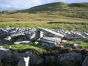
| Labbacallee Labbacallee wedge tomb Labbacallee wedge tomb is a large pre-historic burial monument, located 8km north-west of Fermoy and 2km south-east of Glanworth, County Cork, Ireland. It is the largest Irish wedge tomb.-Features:... |
Cork County Cork County Cork is a county in Ireland. It is located in the South-West Region and is also part of the province of Munster. It is named after the city of Cork . Cork County Council is the local authority for the county... |
52.16983°N 8.33688°W | wedge tomb | - | |
| Legananny Dolmen | Down County Down -Cities:*Belfast *Newry -Large towns:*Dundonald*Newtownards*Bangor-Medium towns:... |
54.323°N 6.020°W | portal tomb | - | |
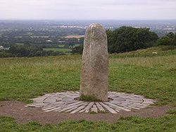 |
Lia Fáil Lia Fáil The Lia Fáil , also known as the Coronation Stone of Tara, is a stone at the Inauguration Mound on the Hill of Tara in County Meath in Ireland, which served as the coronation stone for the High Kings of Ireland. In legend, all of the kings of Ireland were crowned on the stone up to Muirchertach... |
Meath County Meath County Meath is a county in Ireland. It is part of the Mid-East Region and is also located in the province of Leinster. It is named after the ancient Kingdom of Mide . Meath County Council is the local authority for the county... |
53°34′39"N 6°36′43"W | standing stone Standing stone Standing stones, orthostats, liths, or more commonly megaliths are solitary stones set vertically in the ground and come in many different varieties.... |
- |
 |
Listoghil (part of Carrowmore Carrowmore Carrowmore, County Sligo is one of the four major passage tomb cemeteries in Ireland. It is located at the centre of a prehistoric ritual landscape on the Cúil Irra Peninsula in County Sligo in Ireland.... ) |
Sligo | - | - | 5380–5640 years |
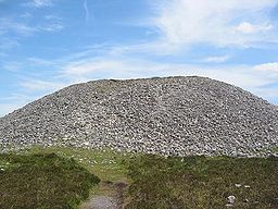
| Loughcrew Cairns Loughcrew Loughcrew is near Oldcastle, County Meath, Ireland. . Loughcrew is a site of considerable historical importance in Ireland... |
Meath County Meath County Meath is a county in Ireland. It is part of the Mid-East Region and is also located in the province of Leinster. It is named after the ancient Kingdom of Mide . Meath County Council is the local authority for the county... |
53°46′10"N 7°6′11"W | cairn Cairn Cairn is a term used mainly in the English-speaking world for a man-made pile of stones. It comes from the or . Cairns are found all over the world in uplands, on moorland, on mountaintops, near waterways and on sea cliffs, and also in barren desert and tundra areas... s |
5300–5500 years | |
 |
Meehambee Dolmen Meehambee Dolmen The Meehambee Dolmen is a megalithic portal tomb dating from about 3500 BC located in the centre of the island of Ireland in County Roscommon.It has been discovered by two local children in the 1960s who have unearthed two stone axes.... |
Roscommon County Roscommon County Roscommon is a county in Ireland. It is located in the West Region and is also part of the province of Connacht. It is named after the town of Roscommon. Roscommon County Council is the local authority for the county... |
- | portal tomb | 5500 years |
| Newgrange Newgrange Newgrange is a prehistoric monument located in County Meath, on the eastern side of Ireland, about one kilometre north of the River Boyne. It was built around 3200 BC , during the Neolithic period... or Sí an Bhrú (part of Brú na Bóinne Brú na Bóinne is a World Heritage Site in County Meath, Ireland and is the largest and one of the most important prehistoric megalithic sites in Europe.-The site:... ) |
Meath County Meath County Meath is a county in Ireland. It is part of the Mid-East Region and is also located in the province of Leinster. It is named after the ancient Kingdom of Mide . Meath County Council is the local authority for the county... |
53°41′39.73"N 6°28′30.11"W | passage tomb | 5000 years | |
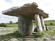 |
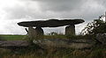
Poulnabrone dolmen Poulnabrone dolmen Poulnabrone Dolmen is a portal tomb in the Burren, County Clare, Ireland, dating back to the Neolithic period, probably between 4200 BC to 2900 BC. It is situated 8km south of Ballyvaughan in the parish of Carran, 9.6km north-west of Kilnaboy... |
Clare County Clare -History:There was a Neolithic civilisation in the Clare area — the name of the peoples is unknown, but the Prehistoric peoples left evidence behind in the form of ancient dolmen; single-chamber megalithic tombs, usually consisting of three or more upright stones... |
53°2′55.83"N 9°8′23.83"W | portal tomb | - |
| Slidderyford Dolmen | Down County Down -Cities:*Belfast *Newry -Large towns:*Dundonald*Newtownards*Bangor-Medium towns:... |
- | portal tomb | - | |
 |
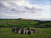
Templebryan Stone Circle Templebryan Stone Circle thumb|300px|right|Templebryan: Nine stones were recorded as standing in the eighteenth century. Today only four are still upright.Templebryan Stone Circle is a stone circle, located north of Clonakilty, County Cork, Ireland. Grid ref: W386 438. Close by lies an Early Christian site... |
Cork County Cork County Cork is a county in Ireland. It is located in the South-West Region and is also part of the province of Munster. It is named after the city of Cork . Cork County Council is the local authority for the county... |
51.64316°N 8.88335°W | stone circle Stone circle A stone circle is a monument of standing stones arranged in a circle. Such monuments have been constructed across the world throughout history for many different reasons.... |
- |
 |
Tibradden | Dublin County Dublin County Dublin is a county in Ireland. It is part of the Dublin Region and is also located in the province of Leinster. It is named after the city of Dublin which is the capital of Ireland. County Dublin was one of the first of the parts of Ireland to be shired by King John of England following the... |
53°14′20.15"N 6°16′52.74"W | passage tomb | - |
| Townleyhall Townleyhall passage grave Townleyhall passage grave is an Irish chamber tomb around 2km north of Dowth tomb and part of the megalithic complex of Brú na Bóinne in County Louth.... (part of Brú na Bóinne Brú na Bóinne is a World Heritage Site in County Meath, Ireland and is the largest and one of the most important prehistoric megalithic sites in Europe.-The site:... ) |
County Louth County Louth County Louth is a county of Ireland. It is part of the Border Region and is also located in the province of Leinster. It is named after the town of Louth. Louth County Council is the local authority for the county... |
- | passage tomb | - | |
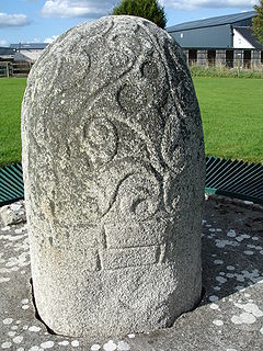 |
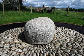
Turoe stone Turoe stone The Turoe stone is a granite stone decorated in a Celtic style located in the village of Bullaun, County Galway, Ireland, 6 km north of Loughrea off the R350 regional road... |
Galway County Galway County Galway is a county in Ireland. It is located in the West Region and is also part of the province of Connacht. It is named after the city of Galway. Galway County Council is the local authority for the county. There are several strongly Irish-speaking areas in the west of the county... |
53°15′N 8°33′W | standing stone Standing stone Standing stones, orthostats, liths, or more commonly megaliths are solitary stones set vertically in the ground and come in many different varieties.... |
- |
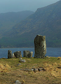 |
Uragh Stone Circle Uragh Stone Circle The Uragh Stone Circle is a neolithic stone circle near Gleninchaquin Park, Tuosist, County Kerry, Ireland. Situated near Lake Inchiquin, it consists of five megaliths. The largest stone is ten feet high and the circle is eight feet in diameter.-References:*... |
Kerry County Kerry Kerry means the "people of Ciar" which was the name of the pre-Gaelic tribe who lived in part of the present county. The legendary founder of the tribe was Ciar, son of Fergus mac Róich. In Old Irish "Ciar" meant black or dark brown, and the word continues in use in modern Irish as an adjective... |
51°48′42.23"N 9°41′37.74"W | stone circle Stone circle A stone circle is a monument of standing stones arranged in a circle. Such monuments have been constructed across the world throughout history for many different reasons.... |
- |