

Knocknakilla
Encyclopedia
Macroom
Macroom is a market town in Ireland located in a valley on the River Sullane, a tributary of the River Lee, between Cork and Killarney. It is one of the key gateways to the tourist region of West Cork. The town recorded a population on 3,553 in the 2006 national census...
and Millstreet
Millstreet
Millstreet is a town in north County Cork, Ireland with a population of approximately 1,500. It is located at the foot of Clara Mountain. The town's Catholic church is dedicated to St. Patrick. Since October 1985, the town has been twinned with Pommerit-le-Vicomte in Brittany, France...
, in County Cork
County Cork
County Cork is a county in Ireland. It is located in the South-West Region and is also part of the province of Munster. It is named after the city of Cork . Cork County Council is the local authority for the county...
, Ireland
Republic of Ireland
Ireland , described as the Republic of Ireland , is a sovereign state in Europe occupying approximately five-sixths of the island of the same name. Its capital is Dublin. Ireland, which had a population of 4.58 million in 2011, is a constitutional republic governed as a parliamentary democracy,...
. It is set in blanket peatland on the north-west upper slopes of Musherabeg mountain, and is said to be 3500 years old. The Knocknakilla area is rich with archaeological artefacts and nearby are two cashels, a ringfort
Ringfort
Ringforts are circular fortified settlements that were mostly built during the Iron Age , although some were built as late as the Early Middle Ages . They are found in Northern Europe, especially in Ireland...
, two fulacht fiadh
Fulacht fiadh
A fulacht fiadh is a type of archaeological site found in Ireland. In England, Scotland, Wales and the Isle of Man they are known as burnt mounds. They commonly survive as a low horseshoe-shaped mound of charcoal-enriched soil and heat shattered stone with a slight depression at its centre showing...
, a possible souterrain
Souterrain
Souterrain is a name given by archaeologists to a type of underground structure associated mainly with the Atlantic Iron Age. These structures appear to have been brought northwards from Gaul during the late Iron Age. Regional names include earth houses, fogous and Pictish houses...
and a circular enclosure. Given their relation to both the rising and setting sun, it is thought that they were erected and aligned with purpose. This theory holds that they functioned as calendars and may have been of assistance to early farmers.
The complex includes a Megalithic Complex which is found on a level patch of bogland overlooking a deep valley, and comprises a recumbent stone circle
Stone circle
A stone circle is a monument of standing stones arranged in a circle. Such monuments have been constructed across the world throughout history for many different reasons....
, a radial cairn and two pointy typed portal stones (one of which has fallen), aligned north-northeast to south-southwest. The stone circle is made up of five 1.3- to 1.5-metre-high stones, of which two (the axis and east sidestone) fell sometime in the last 50 years. Only the two northern portal stones and a stone at the west stand today. The stone row, made up of two stones both over 3.5 metres tall, seems to have been aligned on the stone circle, although the stone nearest the circle has fallen, and the remaining stone has a pronounced lean. Three meters away is a 10-stone, 3.5-metre-diameter, radial cairn which was first discovered by Coillte Teoranta
Coillte Teoranta
Coillte is a state-sponsored company in the Republic of Ireland, based in Newtownmountkennedy. Coillte is a commercial company operating in forestry, land-based businesses and added-value processing operations....
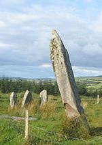
in 1970. The upright standing stone is 3.7 metres tall, and it leans heavily to the north.
Nearby is a Dolmen consisting of a long flat capstone supported by three upright stones. Further away is a 1.65-metre-high single standing stone
Standing stone
Standing stones, orthostats, liths, or more commonly megaliths are solitary stones set vertically in the ground and come in many different varieties....
. It is northeast-southwest facing, and rectangular in plan. The stone narrows towards the top, and is leaning to the northeast.