

Corick
Encyclopedia
Magherafelt District Council
Magherafelt District Council is a district council in County Londonderry in Northern Ireland. Council headquarters are in Magherafelt. The Council area stretches from Lough Neagh and the River Bann in the east and into the Sperrin Mountains in the west and is divided by the Moyola River. It covers...
, County Londonderry
County Londonderry
The place name Derry is an anglicisation of the old Irish Daire meaning oak-grove or oak-wood. As with the city, its name is subject to the Derry/Londonderry name dispute, with the form Derry preferred by nationalists and Londonderry preferred by unionists...
, Northern Ireland
Northern Ireland
Northern Ireland is one of the four countries of the United Kingdom. Situated in the north-east of the island of Ireland, it shares a border with the Republic of Ireland to the south and west...
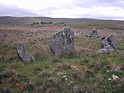
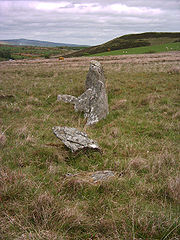
. It includes a stone circle
Stone circle
A stone circle is a monument of standing stones arranged in a circle. Such monuments have been constructed across the world throughout history for many different reasons....
and a stone row
Stone row
A stone row , is a linear arrangement of upright, parallel megalithic standing stones set at intervals along a common axis or series of axes, usually dating from the later Neolithic or Bronze Age. Rows may be individual or grouped, and three or more stones aligned can constitute a stone row...
. The Corick stone circles and alignments are located 2 km north east of Ballybriest court-tomb, 400 metres south of Corick clachan
Clachan
A clachan is a type of small traditional settlement common in Ireland and Scotland until the middle of the 20th century. It is usually defined as a small village lacking a church, post office, or other formal building. Their origin is unknown, but it is likely that they are of a very ancient...
, near a stream. There are some 5 circles (one with a large standing-stone in the middle) and 3 stone-rows. The stone alignments and circle are Scheduled Historic Monuments in the townland
Townland
A townland or bally is a small geographical division of land used in Ireland. The townland system is of Gaelic origin—most townlands are believed to pre-date the Norman invasion and most have names derived from the Irish language...
of Corick, in Magherafelt District Council
Magherafelt District Council
Magherafelt District Council is a district council in County Londonderry in Northern Ireland. Council headquarters are in Magherafelt. The Council area stretches from Lough Neagh and the River Bann in the east and into the Sperrin Mountains in the west and is divided by the Moyola River. It covers...
area, at grid reference: Area of H780 896.