
List of districts of Maharashtra
Encyclopedia

States and territories of India
India is a federal union of states comprising twenty-eight states and seven union territories. The states and territories are further subdivided into districts and so on.-List of states and territories:...
of Maharashtra
Maharashtra
Maharashtra is a state located in India. It is the second most populous after Uttar Pradesh and third largest state by area in India...
came into existence on May 1, 1960 (also known as Maharashtra Day
Maharashtra Day
Maharashtra Day on May 1 is celebrated in Maharashtra, a state on western coast of India. Maharashtra attained statehood on 1st of May, 1960 when the then state Bombay state was divided into two states, Maharashtra and Gujarat on the basis of different languages, Marathi and Gujarati, under the...
), initially with 28 district
District
Districts are a type of administrative division, in some countries managed by a local government. They vary greatly in size, spanning entire regions or counties, several municipalities, or subdivisions of municipalities.-Austria:...
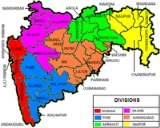
s. 7 new districts have been created since then and currently the number of districts in the state is 35. These districts are grouped into six administrative divisions.
Regions and Divisions
Maharashtra is divided into thirty-five districts, which are grouped into six divisions. These are official revenue divisions of government of Maharashtra.Regions
Geographically, historically and according to political sentiments, Maharashtra has five main regions:- Vidarbha RegionVidarbhaVidarbha is the eastern region of Maharashtra state made up of Nagpur Division and Amravati Division. Its former name is Berar . It occupies 31.6% of total area and holds 21.3% of total population of Maharashtra...
- (NagpurNagpur DivisionNagpur Division is one of six administrative divisions of Maharashtra State in India. Nagpur is the easternmost division in the state, with an administrative headquarters in the city of Nagpur...
and AmravatiAmravati DivisionAmravati division is one of the six administrative divisions of Maharashtra state in India. Amravati and Nagpur divisions constitute the ancient Vidarbha region...
divisions) - (Old Berar RegionCentral Provinces and BerarThe Central Provinces and Berar was a province of British India. The province comprised British conquests from the Mughals and Marathas in central India, and covered much of present-day Madhya Pradesh, Chhattisgarh and Maharashtra states. Its capital was Nagpur. The Central Provinces was formed in...
) - Marathwada RegionMarathwadaThe name Marathwada identifies one of the five regions in Maharashtra state of India. The region coincides with the Aurangabad Division.-Historical highlights:...
- (Aurangabad DivisionAurangabad DivisionAurangabad Division is one of the six administrative divisions of Maharashtra state in India. Aurangabad divisions almost completely coincides with the Marathwada region of Maharashtra.-Districts:...
) - Khandesh and Northern Maharashtra RegionKhandeshKhandesh is a region of central India, which forms the northwestern portion of Maharashtra state.Khandesh was the terminal territorial part under the rule of Mughals. The Start of Deccan region demarcated by the boundary of Khandesh....
- (Nashik DivisionNashik Division* this division is known as North MaharashtraNasik division is one of the six divisions of India's Maharashtra state. The historic Khandesh region covers the northern part of the division, in the valley of the Tapti River...
) - Desh or Western Maharashtra Region - (Pune DivisionPune DivisionPune Division is one of the six administrative divisions of India's Maharashtra state. Pune Division is bound by Konkan Division to the west, Nashik Division to the north, Aurangabad Division to the east, and Karnataka State to the south.* Area: 58,268 km²...
) - KonkanKonkanThe Konkan also called the Konkan Coast or Karavali is a rugged section of the western coastline of India from Raigad to Mangalore...
- (Mumbai Division)
Divisions
| Name of Division (Headquarter) |
Region | Districts | Largest City |
|---|---|---|---|
| Amravati Division Amravati Division Amravati division is one of the six administrative divisions of Maharashtra state in India. Amravati and Nagpur divisions constitute the ancient Vidarbha region... (HQ: Amravati Amravati Amravati is a city in the state of Maharashtra, India and the seventh most populous metropolitan area in Maharashtra. It is also the administrative headquarters of the Amravati district... ) |
Vidarbha Vidarbha Vidarbha is the eastern region of Maharashtra state made up of Nagpur Division and Amravati Division. Its former name is Berar . It occupies 31.6% of total area and holds 21.3% of total population of Maharashtra... |
Akola Akola District Akola is a district in the Indian state of Maharashtra. The city of Akola is the district headquarters. Akola district forms the central part of Amravati Division, and was a former British Raj Berar Province.Area of the district is 5,431 km²... Amravati Amravati district Amravati district is a district of Maharashtra state in central India. Amravati is the administrative headquarters of the district.The district is situated between 20°32' and 21°46' north latitudes and 76°37' and 78°27' east longitudes. The district occupies an area of 12,235 km²... Buldhana Buldhana district -Buldhana district is a district in the Amravati division of Maharashtra state in western India. It is situated at the westernmost border of Vidarbha region of Maharashtra and is 500 km from the state capital, Mumbai... Yavatmal Yavatmal District Yavatmal district is a district of the Indian state of Maharashtra. It is located in the region of Vidarbha, in the east-central part of the state... Washim |
Amravati Amravati Amravati is a city in the state of Maharashtra, India and the seventh most populous metropolitan area in Maharashtra. It is also the administrative headquarters of the Amravati district... |
| Aurangabad Division Aurangabad Division Aurangabad Division is one of the six administrative divisions of Maharashtra state in India. Aurangabad divisions almost completely coincides with the Marathwada region of Maharashtra.-Districts:... (HQ: Aurangabad) |
Marathwada Marathwada The name Marathwada identifies one of the five regions in Maharashtra state of India. The region coincides with the Aurangabad Division.-Historical highlights:... |
Aurangabad Aurangabad District, Maharashtra Aurangabad District is one of the 35 districts of Maharashtra state in western India. It is bordered by the districts of Nashik to the west, Jalgaon to the north, Jalna to the east, and Ahmednagar to the south. Aurangabad is the headquarters and principal city... Beed Beed district Beed district is an administrative district in the state of Maharashtra in India. The district headquarters are located at Beed. The district occupies an area of 10,693 km² and has a population of 2,161,250 of which 17.91% were urban .-History:Beed district has a long history of many rulers... Hingoli Hingoli district Hingoli district is an administrative district in the state of Maharashtra in India. The district headquarters are located at Hingoli. The district occupies an area of 4,526 km² and has a population of 987,160 of which 15.60% were urban . This district is part of Aurangabad division... Jalna Jalna district Jalna district is an administrative district in the state of Maharashtra in western India. Jalna town is the district headquarters. The district is part of Aurangabad division. The district occupies an area of 7718 km²... Latur Latur District Latur district is a district in Maharashtra state of India. Latur city is the district headquarters. In the last census on 2001, the total population of the district was 2,080,285. Urban population comprises 20.08% of the total population... Nanded Nanded District Nanded district is a district of Maharashtra state in central India. The city of Nanded is the district headquarters.- Overview :The district has an area of 10,502 km² while according to 2001 census its population is 2,876,259 of which 23.96% were urban... Osmanabad Osmanabad district -Osmanabad district is an administrative district in the state of Maharashtra in India. The district headquarters are located at Osmanabad, erstwhile Dharashiv . Temple of goddess Tuljabhavani at Tulajapur is famous in India... Parbhani Parbhani District Parbhani district earlier also known as Prabhavatinagar, is one of the eight districts in the Marathawada region of Maharashtra State of India. The district had a population of 1,527,715 of which 31.76% were urban as of 2001... |
Aurangabad |
| Mumbai Division (HQ: Mumbai Mumbai Mumbai , formerly known as Bombay in English, is the capital of the Indian state of Maharashtra. It is the most populous city in India, and the fourth most populous city in the world, with a total metropolitan area population of approximately 20.5 million... ) |
Mumbai Mumbai Mumbai , formerly known as Bombay in English, is the capital of the Indian state of Maharashtra. It is the most populous city in India, and the fourth most populous city in the world, with a total metropolitan area population of approximately 20.5 million... |
Mumbai Mumbai Mumbai , formerly known as Bombay in English, is the capital of the Indian state of Maharashtra. It is the most populous city in India, and the fourth most populous city in the world, with a total metropolitan area population of approximately 20.5 million... Mumbai Suburban District Mumbai Mumbai , formerly known as Bombay in English, is the capital of the Indian state of Maharashtra. It is the most populous city in India, and the fourth most populous city in the world, with a total metropolitan area population of approximately 20.5 million... Thane Raigad Raigad district Raigad District , also known as Raigarh District, is a district in the Indian state of Maharashtra. It is located in the Konkan region. The district was renamed after Raigad, the fort which was the former capital of the Maratha leader Shivaji, and is located in the interior regions of the district,... Ratnagiri Ratnagiri District Ratnagiri district is one of the 35 districts of Maharashtra state in western India. Ratnagiri is the district headquarters of the district. The district is 11.33% urban. The district is bounded by the Arabian Sea to the west, Sindhudurg district to the south, Raigad district to the north and... Sindhudurg Sindhudurg district Sindhudurg is an administrative district in the state of Maharashtra in India, which was carved out of the erstwhile Ratnagiri District. The district headquarters are located at Oros . The district occupies an area of 5207 km² and has a population of 868,825 of which 9.47% were urban... |
Mumbai Mumbai Mumbai , formerly known as Bombay in English, is the capital of the Indian state of Maharashtra. It is the most populous city in India, and the fourth most populous city in the world, with a total metropolitan area population of approximately 20.5 million... |
| Nagpur Division Nagpur Division Nagpur Division is one of six administrative divisions of Maharashtra State in India. Nagpur is the easternmost division in the state, with an administrative headquarters in the city of Nagpur... (HQ: Nagpur Nagpur Nāgpur is a city and winter capital of the state of Maharashtra, the largest city in central India and third largest city in Maharashtra after Mumbai and Pune... ) |
Vidarbh | Bhandara Bhandara district Bhandara district is an administrative district in the state of Maharashtra in India. The district headquarters are located at Bhandara. The district occupies an area of 3890 km² and has a population of 1,135,835 of which 15.47% are urban . It is fondly called as the 'District of Lakes'... Chandrapur Chandrapur District Chandrapur District is a district in Nagpur Division of the Indian state of Maharashtra.It is located at the boundary of Andhrapradesh. The district was formerly known as Chanda District. In 1964, it was renamed as Chandrapur. It was the largest district in India until it was split into the... Gadchiroli Gadchiroli District Gadchiroli district is an administrative district in Maharashtra, India. The town of Gadchiroli is the administrative headquarters of the district.... Gondia Gondia District Gondia district , also known as Gondiya district, is an administrative district in the state of Maharashtra in India. The district headquarters are located at Gondia . The district occupies an area of 5,431 km² and has a population of 1,200,707 of which 11.95% were urban... Nagpur Nagpur District Nagpur district is a district in the Vidarbha region of Maharashtra state in central India. The city of Nagpur is the district headquarters. The district is part of Nagpur Division.... Wardha Wardha District Wardha district is one of the 35 districts in Maharashtra state in western India. This district is a part of Nagpur Division. The city of Wardha is the administrative headquarters of the district. The district had a population of 1,236,736 of which 26.28% were urban as of 2001.-History:The History... |
Nagpur Nagpur Nāgpur is a city and winter capital of the state of Maharashtra, the largest city in central India and third largest city in Maharashtra after Mumbai and Pune... |
| Nashik Division Nashik Division * this division is known as North MaharashtraNasik division is one of the six divisions of India's Maharashtra state. The historic Khandesh region covers the northern part of the division, in the valley of the Tapti River... (HQ: Nashik) |
Khandesh and Northern Maharashtra Khandesh Khandesh is a region of central India, which forms the northwestern portion of Maharashtra state.Khandesh was the terminal territorial part under the rule of Mughals. The Start of Deccan region demarcated by the boundary of Khandesh.... |
Ahmednagar Ahmednagar district Ahmednagar district is the largest district of Maharashtra state in western India. The historical Ahmednagar city is the headquarters of the district. Ahmednagar was the seat of the Ahmednagar Sultanate of late medieval period . This district is also known for the towns of Shirdi associated with... Dhule Dhule district Dhule district is a district of Maharashtra state in central India. The city of Dhule is the administrative headquarters of the district.The Dhule district previously comprised tracts of land predominantly inhabited by tribal population... Jalgaon Jalgaon District Jalgaon district is a district of Maharashtra. It was formerly known as East Khandesh district. It has an area of 11,765 km², and a population of 3,682,690 of which 71.4% were rural.... Nandurbar Nandurbar District Nandurbar is an administrative district in the northwest corner of Maharashtra state in India . On 1 July 1998 Dhule was bifurcated as two separate districts now known as Dhule and Nandurbar. The district headquarters are located at Nandurbar city... Nashik Nashik district Nashik district, also known as Nasik district, is a district in Maharashtra, India. The city of Nashik is the administrative headquarters of the district.-Geography:Nashik district has an area of 15,530 square kilometres... |
Nashik |
| Pune Division Pune Division Pune Division is one of the six administrative divisions of India's Maharashtra state. Pune Division is bound by Konkan Division to the west, Nashik Division to the north, Aurangabad Division to the east, and Karnataka State to the south.* Area: 58,268 km²... (HQ: Pune Pune Pune , is the eighth largest metropolis in India, the second largest in the state of Maharashtra after Mumbai, and the largest city in the Western Ghats. Once the centre of power of the Maratha Empire, it is situated 560 metres above sea level on the Deccan plateau at the confluence of the Mula ... ) |
Desh or Western Maharashtra | Kolhapur Kolhapur District Kolhapur district is located in Maharashtra state. The city of Kolhapur is the district headquarters. The district had a population of 3,523,162 of which 29.81% were urban as of 2001... Pune Pune District Pune District is situated in Maharashtra state of India. Pune city is the district headquarters. In the last census on 2001, the total population of the district was 7,232,555, making it the fourth most populous district in India . Urban population comprises 58.08% of the total population... Sangli Sangli district Sangli district is a district of Maharashtra state in west-central India. Sangli city is the district headquarters. The district is 24.51% urban. Sangli and Miraj are the largest cities. The industrial town of Kirloskarwadi is also located in the Sangli District... Satara Satara district Satara District is a district of Maharashtra state in western India with an area of 10,480 km² and a population of 2,808,994 of which 14.17% were urban . Satara is the capital of the district and other major towns include Wai, Karad, Koregaon, Koyananagar, Rahimatpur, Phaltan, Mahabaleshwar... Solapur Solapur District - Solapur District is a district in Maharashtra state of India. The city of Solapur is the district headquarters. It is located on the south east edge of the state and lies entirely in the Bhima and Seena basins. The entire district is drained by the Bhima River.Solapur district leads in beedi... |
Pune Pune Pune , is the eighth largest metropolis in India, the second largest in the state of Maharashtra after Mumbai, and the largest city in the Western Ghats. Once the centre of power of the Maratha Empire, it is situated 560 metres above sea level on the Deccan plateau at the confluence of the Mula ... |
Districts
The table below lists important geographic and demographic parameters for all 35 districts. Population data is extracted from the 2001 Census of India.| Name | Code | Formed | Headquarters | Administrative Division |
Area (km2) | Population (2001 census) |
% of State Population |
Density Population density Population density is a measurement of population per unit area or unit volume. It is frequently applied to living organisms, and particularly to humans... (per km2) |
Urban Urban area An urban area is characterized by higher population density and vast human features in comparison to areas surrounding it. Urban areas may be cities, towns or conurbations, but the term is not commonly extended to rural settlements such as villages and hamlets.Urban areas are created and further... (%) |
Literacy Literacy Literacy has traditionally been described as the ability to read for knowledge, write coherently and think critically about printed material.Literacy represents the lifelong, intellectual process of gaining meaning from print... (%) |
Sex Ratio Sex ratio Sex ratio is the ratio of males to females in a population. The primary sex ratio is the ratio at the time of conception, secondary sex ratio is the ratio at time of birth, and tertiary sex ratio is the ratio of mature organisms.... |
Tehsils | Source |
|---|---|---|---|---|---|---|---|---|---|---|---|---|---|
| Ahmednagar Ahmednagar district Ahmednagar district is the largest district of Maharashtra state in western India. The historical Ahmednagar city is the headquarters of the district. Ahmednagar was the seat of the Ahmednagar Sultanate of late medieval period . This district is also known for the towns of Shirdi associated with... |
AH | 1 May 1960 | Ahmednagar | Nashik Nashik Division * this division is known as North MaharashtraNasik division is one of the six divisions of India's Maharashtra state. The historic Khandesh region covers the northern part of the division, in the valley of the Tapti River... |
17,413 | 40,88,077 | % | 234.77 | 19.67 | 75.82 | 941 | 14 | District website |
| Akola Akola District Akola is a district in the Indian state of Maharashtra. The city of Akola is the district headquarters. Akola district forms the central part of Amravati Division, and was a former British Raj Berar Province.Area of the district is 5,431 km²... |
AK | 1 May 1960 | Akola | Amravati Amravati Division Amravati division is one of the six administrative divisions of Maharashtra state in India. Amravati and Nagpur divisions constitute the ancient Vidarbha region... |
5,417 | 16,30,239 | % | 300.78 | 38.49 | 81.41 | 938 | 7 | District website |
| Amravati Amravati district Amravati district is a district of Maharashtra state in central India. Amravati is the administrative headquarters of the district.The district is situated between 20°32' and 21°46' north latitudes and 76°37' and 78°27' east longitudes. The district occupies an area of 12,235 km²... |
AM | 1 May 1960 | Amravati Amravati Amravati is a city in the state of Maharashtra, India and the seventh most populous metropolitan area in Maharashtra. It is also the administrative headquarters of the Amravati district... |
Amravati Amravati Division Amravati division is one of the six administrative divisions of Maharashtra state in India. Amravati and Nagpur divisions constitute the ancient Vidarbha region... |
12,626 | 26,06,063 | % | 206.40 | 34.50 | 82.5 | 938 | 14 | District website |
| Aurangabad Aurangabad District, Maharashtra Aurangabad District is one of the 35 districts of Maharashtra state in western India. It is bordered by the districts of Nashik to the west, Jalgaon to the north, Jalna to the east, and Ahmednagar to the south. Aurangabad is the headquarters and principal city... |
AU | 1 May 1960 | Aurangabad | Aurangabad Aurangabad Division Aurangabad Division is one of the six administrative divisions of Maharashtra state in India. Aurangabad divisions almost completely coincides with the Marathwada region of Maharashtra.-Districts:... |
10,100 | 28,97,013 | % | 286.83 | 37.53 | 61.15 | 924 | 9 | District website |
| Beed Beed district Beed district is an administrative district in the state of Maharashtra in India. The district headquarters are located at Beed. The district occupies an area of 10,693 km² and has a population of 2,161,250 of which 17.91% were urban .-History:Beed district has a long history of many rulers... |
BI | 1 May 1960 | Beed Beed Beed is a town and administrative headquarters of the district of the same name located in central Maharashtra state of India. According to 2001 census, it is the largest urban area in the district with a population of 138,091. Calculated population of 2010 is 161,604. It ranks 295th in population... |
Aurangabad Aurangabad Division Aurangabad Division is one of the six administrative divisions of Maharashtra state in India. Aurangabad divisions almost completely coincides with the Marathwada region of Maharashtra.-Districts:... |
10,439 | 21,61,250 | % | 207.04 | 17.91 | 68 | 936 | 11 | District website |
| Bhandara Bhandara district Bhandara district is an administrative district in the state of Maharashtra in India. The district headquarters are located at Bhandara. The district occupies an area of 3890 km² and has a population of 1,135,835 of which 15.47% are urban . It is fondly called as the 'District of Lakes'... |
BH | 1 May 1960 | Bhandara Bhandara Bhandara is a city and a municipal council in Bhandara district in the state of Maharashtra, India.- Overview :It is the second major city in Vidharba a region that is Maharashtra. Bhandara is an agricultural centre for the farmers around its region majorly growing rice. The district speaks... |
Nagpur Nagpur Division Nagpur Division is one of six administrative divisions of Maharashtra State in India. Nagpur is the easternmost division in the state, with an administrative headquarters in the city of Nagpur... |
3,717 | 11,35,835 | % | 305.58 | 15.44 | 68.28 | 982 | 7 | District website |
| Buldhana Buldhana district -Buldhana district is a district in the Amravati division of Maharashtra state in western India. It is situated at the westernmost border of Vidarbha region of Maharashtra and is 500 km from the state capital, Mumbai... |
BU | 1 May 1960 | Buldhana | Amravati Amravati Division Amravati division is one of the six administrative divisions of Maharashtra state in India. Amravati and Nagpur divisions constitute the ancient Vidarbha region... |
9,680 | 22,32,480 | % | 230.63 | 21.2 | 75.8 | 946 | 13 | District website |
| Chandrapur Chandrapur District Chandrapur District is a district in Nagpur Division of the Indian state of Maharashtra.It is located at the boundary of Andhrapradesh. The district was formerly known as Chanda District. In 1964, it was renamed as Chandrapur. It was the largest district in India until it was split into the... |
CH | 1 May 1960 | Chandrapur Chandrapur Chandrapur is city and a municipal council in Chandrapur district in the state of Maharashtra, India. It is also the headquarters of Chandrapur district.... |
Nagpur Nagpur Division Nagpur Division is one of six administrative divisions of Maharashtra State in India. Nagpur is the easternmost division in the state, with an administrative headquarters in the city of Nagpur... |
10,695 | 20,71,101 | % | 193.65 | 32.11 | 73.03 | 948 | 15 | District website |
| Dhule Dhule district Dhule district is a district of Maharashtra state in central India. The city of Dhule is the administrative headquarters of the district.The Dhule district previously comprised tracts of land predominantly inhabited by tribal population... |
DH | 1 May 1960 | Dhule Dhule Dhule is a city and a Municipal Corporation in Dhule district in northwestern part of Maharashtra state, India. It is one of the very few well-planned cities of India before Indian Independence.-Geography:Dhule is located at... |
Nashik Nashik Division * this division is known as North MaharashtraNasik division is one of the six divisions of India's Maharashtra state. The historic Khandesh region covers the northern part of the division, in the valley of the Tapti River... |
8,063 | 17,07,947 | % | 211.83 | 26.11 | 71.6 | 944 | 4 | District website |
| Gadchiroli Gadchiroli District Gadchiroli district is an administrative district in Maharashtra, India. The town of Gadchiroli is the administrative headquarters of the district.... |
GA | 26 August 1982 | Gadchiroli Gadchiroli Gadchiroli is a town and a municipal council in Gadchiroli district in the state of Maharashtra, central India. It is the administrative headquarters of the district.It is very lush in Monsoon season but also prone to flooding.... |
Nagpur Nagpur Division Nagpur Division is one of six administrative divisions of Maharashtra State in India. Nagpur is the easternmost division in the state, with an administrative headquarters in the city of Nagpur... |
14,412 | 9,70,294 | % | 67.33 | 6.93 | 60.1 | 976 | 12 | District website |
| Gondia Gondia District Gondia district , also known as Gondiya district, is an administrative district in the state of Maharashtra in India. The district headquarters are located at Gondia . The district occupies an area of 5,431 km² and has a population of 1,200,707 of which 11.95% were urban... |
GO | 1 May 1999 | Gondia Gondia Gondia, or Gondiya , is a city in the state of Maharashtra in western India, and is the administrative headquarters of Gondia District. Gondia is also known as Rice City by local people due to abundance of rice mills in the area. Gondia is very close to Madhya Pradesh state, and is considered the... |
Nagpur Nagpur Division Nagpur Division is one of six administrative divisions of Maharashtra State in India. Nagpur is the easternmost division in the state, with an administrative headquarters in the city of Nagpur... |
4,843 | 12,00,151 | % | 247.81 | 11.95 | 67.67 | 1005 | 8 | District website |
| Hingoli Hingoli district Hingoli district is an administrative district in the state of Maharashtra in India. The district headquarters are located at Hingoli. The district occupies an area of 4,526 km² and has a population of 987,160 of which 15.60% were urban . This district is part of Aurangabad division... |
HI | 1 May 1999 | Hingoli Hingoli Hingoli is a city and a municipal council in Hingoli district in the Indian state of Maharashtra.-History:Marathwada was initially under Nizam's regime. Hingoli was the taluka of parbhani district and part of Nizam's regime. It was actually Nizam's military base as it was border place with... |
Aurangabad Aurangabad Division Aurangabad Division is one of the six administrative divisions of Maharashtra state in India. Aurangabad divisions almost completely coincides with the Marathwada region of Maharashtra.-Districts:... |
4,526 | 9,87,160 | % | 218.11 | 15.2 | 66.86 | 953 | 5 | District website |
| Jalgaon Jalgaon District Jalgaon district is a district of Maharashtra. It was formerly known as East Khandesh district. It has an area of 11,765 km², and a population of 3,682,690 of which 71.4% were rural.... |
JG | 1 May 1960 | Jalgaon | Nashik Nashik Division * this division is known as North MaharashtraNasik division is one of the six divisions of India's Maharashtra state. The historic Khandesh region covers the northern part of the division, in the valley of the Tapti River... |
11,765 | 36,79,936 | % | 312.79 | 71.4 | 76.06 | 932 | 15 | District website |
| Jalna Jalna district Jalna district is an administrative district in the state of Maharashtra in western India. Jalna town is the district headquarters. The district is part of Aurangabad division. The district occupies an area of 7718 km²... |
JN | 1 May 1960 | Jalna Jalna (city) Jalna is a city and a municipal council in Jalna district in the Indian state of Maharashtra. Jalna was formerly a part of Nizam State as a tahsil of Aurangabad district.... |
Aurangabad Aurangabad Division Aurangabad Division is one of the six administrative divisions of Maharashtra state in India. Aurangabad divisions almost completely coincides with the Marathwada region of Maharashtra.-Districts:... |
7,612 | 16,12,357 | % | 211.82 | 19.09 | 64.52 | 952 | 8 | District website |
| Kolhapur Kolhapur District Kolhapur district is located in Maharashtra state. The city of Kolhapur is the district headquarters. The district had a population of 3,523,162 of which 29.81% were urban as of 2001... |
KO | 1 May 1960 | Kolhapur | Pune Pune Division Pune Division is one of the six administrative divisions of India's Maharashtra state. Pune Division is bound by Konkan Division to the west, Nashik Division to the north, Aurangabad Division to the east, and Karnataka State to the south.* Area: 58,268 km²... |
7,685 | 35,15,413 | % | 457.44 | 29.65 | 77.23 | 949 | 10 | District website |
| Latur Latur District Latur district is a district in Maharashtra state of India. Latur city is the district headquarters. In the last census on 2001, the total population of the district was 2,080,285. Urban population comprises 20.08% of the total population... |
LA | 1 May 1960 | Latur LaTur La Tur was a Mexican airline that operated from 1988 until 1992 when it was taken over by TAESA.-Company history:Set up in 1988 to help develop the tourist market, La Tur began operations using McDonnell Douglas MD-83 aircraft. One year later, the Airbus A300-600 was introduced for flights to Europe... |
Aurangabad Aurangabad Division Aurangabad Division is one of the six administrative divisions of Maharashtra state in India. Aurangabad divisions almost completely coincides with the Marathwada region of Maharashtra.-Districts:... |
7,372 | 20,80,285 | % | 282.19 | 23.57 | 71.54 | 935 | 10 | District website |
| Mumbai City Mumbai City District Mumbai City District is a district of Maharashtra in Konkan Division. As a city district, it has no headquarters or subdivisions. It, along with the Mumbai Suburban District make up the metropolis of Mumbai. The city area is called the "island city" or South Mumbai or Old Mumbai. It extends from... |
MC | 1 May 1960 | Mumbai Mumbai Mumbai , formerly known as Bombay in English, is the capital of the Indian state of Maharashtra. It is the most populous city in India, and the fourth most populous city in the world, with a total metropolitan area population of approximately 20.5 million... |
Konkan Konkan Division Konkan division is one of the six administrative divisions of Maharashtra state in India. It comprises the Konkan region, which occupies the entire west coast of Maharashtra... |
67.7 | 33,26,837 | % | 49,140.9 | 100 | 86.4 | 777 | 0 | District website |
| Mumbai Suburban Mumbai Suburban District The Mumbai Suburban district is a district of the state of Maharashtra in western India. Its headquarters is in Bandra . It consists of three administrative subdivisions or tehsils: Kurla, Andheri, and Borivali. The district along with Mumbai City district make up the metropolis of Mumbai... |
MU | 1 October 1990 | Bandra (East) | Konkan Konkan Division Konkan division is one of the six administrative divisions of Maharashtra state in India. It comprises the Konkan region, which occupies the entire west coast of Maharashtra... |
369 | 85,87,000 | % | 23,271 | 100 | 86.9 | 822 | 3 | District website |
| Nagpur Nagpur District Nagpur district is a district in the Vidarbha region of Maharashtra state in central India. The city of Nagpur is the district headquarters. The district is part of Nagpur Division.... |
NG | 1 May 1960 | Nagpur Nagpur Nāgpur is a city and winter capital of the state of Maharashtra, the largest city in central India and third largest city in Maharashtra after Mumbai and Pune... |
Nagpur Nagpur Division Nagpur Division is one of six administrative divisions of Maharashtra State in India. Nagpur is the easternmost division in the state, with an administrative headquarters in the city of Nagpur... |
9,897 | 40,51,444 | % | 409.36 | 64.33 | 84.18 | 933 | 13 | District website |
| Nanded Nanded District Nanded district is a district of Maharashtra state in central India. The city of Nanded is the district headquarters.- Overview :The district has an area of 10,502 km² while according to 2001 census its population is 2,876,259 of which 23.96% were urban... |
ND | 1 May 1960 | Nanded Nanded Nanded is the second largest city in the Marathwada region of Maharashtra, India. It is also headquarters of Nanded district in the Marathwada Division of the state. It is an important holy place for the Sikh faith and is famous for the Hazur Sahib Gurudwara. It is the district headquarters once... |
Aurangabad Aurangabad Division Aurangabad Division is one of the six administrative divisions of Maharashtra state in India. Aurangabad divisions almost completely coincides with the Marathwada region of Maharashtra.-Districts:... |
10,422 | 28,76,259 | % | 275.98 | 28.29 | 68.52 | 942 | 16 | District website |
| Nandurbar Nandurbar District Nandurbar is an administrative district in the northwest corner of Maharashtra state in India . On 1 July 1998 Dhule was bifurcated as two separate districts now known as Dhule and Nandurbar. The district headquarters are located at Nandurbar city... |
NB | 1 July 1998 | Nandurbar Nandurbar Nandurbar is a city and a municipal council in Nandurbar district in the Indian state of Maharashtra. It came into limelight during February 2006 Bird Flu crisis which struck many of its poultry farms. Thousand of chickens from the farms had to be killed and buried in nearby grounds to stop the... |
Nashik Nashik Division * this division is known as North MaharashtraNasik division is one of the six divisions of India's Maharashtra state. The historic Khandesh region covers the northern part of the division, in the valley of the Tapti River... |
5,035 | 13,09,135 | % | 260 | 15.5 | 46.63 | 975 | 6 | District website |
| Nashik Nashik district Nashik district, also known as Nasik district, is a district in Maharashtra, India. The city of Nashik is the administrative headquarters of the district.-Geography:Nashik district has an area of 15,530 square kilometres... |
NS | 1 May 1960 | Nashik | Nashik Nashik Division * this division is known as North MaharashtraNasik division is one of the six divisions of India's Maharashtra state. The historic Khandesh region covers the northern part of the division, in the valley of the Tapti River... |
15,530 | 49,93,796 | % | 321.56 | 38.8 | 74.4 | 927 | 15 | District website |
| Osmanabad Osmanabad district -Osmanabad district is an administrative district in the state of Maharashtra in India. The district headquarters are located at Osmanabad, erstwhile Dharashiv . Temple of goddess Tuljabhavani at Tulajapur is famous in India... |
OS | 1 May 1960 | Osmanabad Osmanabad Osmanabad is a city and a municipal council in Osmanabad district in the Indian state of Maharashtra.-Geography:The city of Osmanabad is located at . It has an average elevation of 647 metres .... |
Aurangabad Aurangabad Division Aurangabad Division is one of the six administrative divisions of Maharashtra state in India. Aurangabad divisions almost completely coincides with the Marathwada region of Maharashtra.-Districts:... |
7,512 | 14,86,586 | % | 197.89 | 15.7 | 54.27 | 932 | 8 | District website |
| Parbhani Parbhani District Parbhani district earlier also known as Prabhavatinagar, is one of the eight districts in the Marathawada region of Maharashtra State of India. The district had a population of 1,527,715 of which 31.76% were urban as of 2001... |
PA | 1 May 1960 | Parbhani Parbhani Parbhani is a city in Parbhani district in the Indian state of Maharashtra. Parbhani, formerly known as “Prabhavatinagar”, is a city in the Marathwada region of Maharashtra. It is the administrative headquarters of Parbhani District.Parbhani is approximately situated at the centre of Maharashtra... |
Aurangabad Aurangabad Division Aurangabad Division is one of the six administrative divisions of Maharashtra state in India. Aurangabad divisions almost completely coincides with the Marathwada region of Maharashtra.-Districts:... |
6,251 | 15,27,715 | % | 244.4 | 31.8 | 55.15 | 958 | 9 | District website |
| Pune Pune District Pune District is situated in Maharashtra state of India. Pune city is the district headquarters. In the last census on 2001, the total population of the district was 7,232,555, making it the fourth most populous district in India . Urban population comprises 58.08% of the total population... |
PU | 1 May 1960 | Pune Pune Pune , is the eighth largest metropolis in India, the second largest in the state of Maharashtra after Mumbai, and the largest city in the Western Ghats. Once the centre of power of the Maratha Empire, it is situated 560 metres above sea level on the Deccan plateau at the confluence of the Mula ... |
Pune Pune Division Pune Division is one of the six administrative divisions of India's Maharashtra state. Pune Division is bound by Konkan Division to the west, Nashik Division to the north, Aurangabad Division to the east, and Karnataka State to the south.* Area: 58,268 km²... |
15,642 | 72,24,224 | % | 461.85 | 58.1 | 80.78 | 919 | 14 | District website |
| Raigad Raigad district Raigad District , also known as Raigarh District, is a district in the Indian state of Maharashtra. It is located in the Konkan region. The district was renamed after Raigad, the fort which was the former capital of the Maratha leader Shivaji, and is located in the interior regions of the district,... |
RG | 1 May 1960 | Alibag Alibag Alibag or Alibaug or Alibagh is a coastal town and a municipal council in Raigad District in the Konkan region of Maharashtra, India. It is also the headquarters of the Raigad district. The town and its surrounding villages are the historic hinterland of Bene Israeli Jews... |
Konkan Konkan Division Konkan division is one of the six administrative divisions of Maharashtra state in India. It comprises the Konkan region, which occupies the entire west coast of Maharashtra... |
7,148 | 22,07,929 | % | 308.89 | 24.2 | 77 | 976 | 15 | District website |
| Ratnagiri Ratnagiri District Ratnagiri district is one of the 35 districts of Maharashtra state in western India. Ratnagiri is the district headquarters of the district. The district is 11.33% urban. The district is bounded by the Arabian Sea to the west, Sindhudurg district to the south, Raigad district to the north and... |
RT | 1 May 1960 | Ratnagiri Ratnagiri Ratnāgiri is a port city on the Arabian Sea coast in Ratnagiri district in the southwestern part of Maharashtra, India. The district is a part of Konkan.The Sahyadri mountains border Ratnagiri to the east... |
Konkan Konkan Division Konkan division is one of the six administrative divisions of Maharashtra state in India. It comprises the Konkan region, which occupies the entire west coast of Maharashtra... |
8,208 | 16,96,777 | % | 206.72 | 11.3 | 65.13 | 1,136 | 9 | District website |
| Sangli Sangli district Sangli district is a district of Maharashtra state in west-central India. Sangli city is the district headquarters. The district is 24.51% urban. Sangli and Miraj are the largest cities. The industrial town of Kirloskarwadi is also located in the Sangli District... |
SN | 1 May 1960 | Sangli Sangli Sangli is a city in the state of Maharashtra of India. Sangli is known as the Turmeric city for its vast production of Turmeric. Sangli is situated on the banks of river Krishna and is the largest market place for Turmeric in Asia and houses many sugar factories, which it is also noted for... |
Pune Pune Division Pune Division is one of the six administrative divisions of India's Maharashtra state. Pune Division is bound by Konkan Division to the west, Nashik Division to the north, Aurangabad Division to the east, and Karnataka State to the south.* Area: 58,268 km²... |
8,578 | 25,83,524 | % | 301.18 | 24.5 | 62.41 | 957 | 10 | District website |
| Satara Satara district Satara District is a district of Maharashtra state in western India with an area of 10,480 km² and a population of 2,808,994 of which 14.17% were urban . Satara is the capital of the district and other major towns include Wai, Karad, Koregaon, Koyananagar, Rahimatpur, Phaltan, Mahabaleshwar... |
ST | 1 May 1960 | Satara Satara Satara is a city located in the Satara District of Maharashtra state of India. The town is 2320 ft. above sea-level, near the confluence of the Krishna and its tributary river Venna. The city was the capital of the Maratha empire in the 17th century, hence one of the the historical cities of... |
Pune Pune Division Pune Division is one of the six administrative divisions of India's Maharashtra state. Pune Division is bound by Konkan Division to the west, Nashik Division to the north, Aurangabad Division to the east, and Karnataka State to the south.* Area: 58,268 km²... |
10,484 | 27,96,906 | % | 266.77 | 14.2 | 78.52 | 995 | 11 | District website |
| Sindhudurg Sindhudurg district Sindhudurg is an administrative district in the state of Maharashtra in India, which was carved out of the erstwhile Ratnagiri District. The district headquarters are located at Oros . The district occupies an area of 5207 km² and has a population of 868,825 of which 9.47% were urban... |
SI | 1 May 1981 | Oros Oros Oros is a town and the district headquarters of the Sindhudurg district. Most people of this region speak Malvani which is a dialect of Konkani.- See also :* Malvan* Vengurla* Savantwadi* Kudal* Kankavli* Amboli* Banda... |
Konkan Konkan Division Konkan division is one of the six administrative divisions of Maharashtra state in India. It comprises the Konkan region, which occupies the entire west coast of Maharashtra... |
5,207 | 8,68,825 | % | 166.86 | 9.5 | 80.3 | 1,079 | 8 | District website |
| Solapur Solapur District - Solapur District is a district in Maharashtra state of India. The city of Solapur is the district headquarters. It is located on the south east edge of the state and lies entirely in the Bhima and Seena basins. The entire district is drained by the Bhima River.Solapur district leads in beedi... |
SO | 1 May 1960 | Solapur Solapur Solapur is a city in South Western Maharashtra, India governed by municipal corporation.Solapur is one of the four districts that form the region of Western Maharashtra . It is the fourth largest district in Maharashtra in terms of land area and seventh largest in terms of population... |
Pune Pune Division Pune Division is one of the six administrative divisions of India's Maharashtra state. Pune Division is bound by Konkan Division to the west, Nashik Division to the north, Aurangabad Division to the east, and Karnataka State to the south.* Area: 58,268 km²... |
14,845 | 38,49,543 | % | 259.32 | 31.8 | 71.2 | 935 | 11 | District website |
| Thane Thane District Thane is a district in northern Maharashtra state in western India. As of 2011 it is the most populated district in the nation. The headquarters of the district is the city of Thane. Other major cities in the district are Navi Mumbai , Kalyan-Dombivli, Mira-Bhayander, Bhiwandi, Ulhasnagar,... |
TH | 1 May 1960 | Thane Thane Thane , is a city in Maharashtra, India, part of the Mumbai Metropolitan Region, northeastern suburb of Mumbai at the head of the Thane Creek. It is the administrative headquarters of Thane district. On 16 April 1853, G.I.P... |
Konkan Konkan Division Konkan division is one of the six administrative divisions of Maharashtra state in India. It comprises the Konkan region, which occupies the entire west coast of Maharashtra... |
9,558 | 81,31,849 | % | 850.71 | 72.58 | 80.67 | 858 | 15 | District website |
| Wardha Wardha District Wardha district is one of the 35 districts in Maharashtra state in western India. This district is a part of Nagpur Division. The city of Wardha is the administrative headquarters of the district. The district had a population of 1,236,736 of which 26.28% were urban as of 2001.-History:The History... |
WR | 1 May 1960 | Wardha Wardha Wardha is a city and a municipal council in Wardha district in the Indian state of Maharashtra. It is the administrative headquarters of Wardha district. Wardha gets its name from the Wardha River which flows at the North, West and South boundaries of district. Founded in 1866, the town is now an... |
Nagpur Nagpur Division Nagpur Division is one of six administrative divisions of Maharashtra State in India. Nagpur is the easternmost division in the state, with an administrative headquarters in the city of Nagpur... |
6,310 | 12,30,640 | % | 195.03 | 25.17 | 80.5 | 936 | 8 | District website |
| Washim Washim district Washim is a district in Maharashtra, India. The headquarters is at Washim. The area of the district is 5,150 km².-Demography and Geography:... |
WS | 1 July 1998 | Washim Washim Washim is a city and a municipal council in Washim district in the Indian state of Maharashtra. Washim is the district headquarter of newly formed Washim district.... |
Amravati Amravati Division Amravati division is one of the six administrative divisions of Maharashtra state in India. Amravati and Nagpur divisions constitute the ancient Vidarbha region... |
5,150 | 10,20,216 | % | 275.98 | 17.49 | 74.02 | 939 | 6 | District website |
| Yavatmal Yavatmal District Yavatmal district is a district of the Indian state of Maharashtra. It is located in the region of Vidarbha, in the east-central part of the state... |
YA | 1 May 1960 | Yavatmal Yavatmal Yavatmal is a city and municipal council of the Yavatmal district in the Indian state of Maharashtra. The name derives from the Marathi Yavat and mal .-Demographics:yavatmal ,district in Amravati administrative division.... |
Amravati Amravati Division Amravati division is one of the six administrative divisions of Maharashtra state in India. Amravati and Nagpur divisions constitute the ancient Vidarbha region... |
13,582 | 20,77,144 | % | 152.93 | 18.6 | 57.96 | 951 | 16 | District website |
| Maharashtra | - | - | - | - | 3,07,713 | 9,68,78,627 | - | 314.42 | 42.43 | 77.27 | 922 | - | - |
See also
Tehsils in MaharashtraTehsils in Maharashtra
The Table below list all the tehsils of all the 35 districts in the Indian state of Maharashtra along with district-subdivision and urban status information.-Table:...
Maharashtra
Maharashtra
Maharashtra is a state located in India. It is the second most populous after Uttar Pradesh and third largest state by area in India...