

List of crossings of the South Saskatchewan River
Encyclopedia
This is a list of crossings of the South Saskatchewan River
in the Canadian provinces of Saskatchewan
and Alberta
, from the river's confluence with the North Saskatchewan River
at Saskatchewan River Forks
, upstream to its origin at the confluence of the Bow
and Oldman River
s.
across the South Saskatchewan River.
around Saskatoon
. The city of Medicine Hat
hosted a public meeting proposing a Sanitary Sewer and Water Pipeline which is intended to cross the South Saskatchewan River.

South Saskatchewan River
The South Saskatchewan River is a major river in Canada that flows through the provinces of Alberta and Saskatchewan....
in the Canadian provinces of Saskatchewan
Saskatchewan
Saskatchewan is a prairie province in Canada, which has an area of . Saskatchewan is bordered on the west by Alberta, on the north by the Northwest Territories, on the east by Manitoba, and on the south by the U.S. states of Montana and North Dakota....
and Alberta
Alberta
Alberta is a province of Canada. It had an estimated population of 3.7 million in 2010 making it the most populous of Canada's three prairie provinces...
, from the river's confluence with the North Saskatchewan River
North Saskatchewan River
The North Saskatchewan River is a glacier-fed river that flows east from the Canadian Rockies to central Saskatchewan. It is one of two major rivers that join to make up the Saskatchewan River....
at Saskatchewan River Forks
Saskatchewan River Forks
Saskatchewan River Forks refers to the area in Canada where the North Saskatchewan and South Saskatchewan rivers merge to create the Saskatchewan River...
, upstream to its origin at the confluence of the Bow
Bow River
The Bow River is a river in the Canadian province of Alberta. It is a tributary of the South Saskatchewan River, and is considered the headwater of the Nelson River....
and Oldman River
Oldman River
The Oldman River is a river in southern Alberta, Canada. It flows roughly west to east from the Rocky Mountains, through the communities of Fort Macleod, Lethbridge, Taber, and on to Grassy Lake, where it joins with the Bow River to form the South Saskatchewan River, which eventually drains into...
s.
| Crossing | Carries | Location | Notes | Coordinates |
|---|---|---|---|---|
Saskatchewan |
||||
| Weldon Ferry Weldon Ferry The Weldon Ferry is a ferry in the Canadian province of Saskatchewan. The ferry crosses the South Saskatchewan River, linking Highway 682 with Highway 302 north of Weldon.... |
Highway 302 Saskatchewan Highway 302 Highway 302 is a highway in the Canadian province of Saskatchewan. It runs from the northern terminal of the Weldon Ferry, which connects to Highway 682 across the South Saskatchewan River, to a dead end near the Nisbet Provincial Forest... to Grid road 682 Saskatchewan Highway 682 Highway 682 is a highway in the Canadian province of Saskatchewan. It runs from Highway 42 near Meskanaw to the southern terminal of the Weldon Ferry across the South Saskatchewan River, which connects to Highway 302. Highway 682 is about 60 km long.Highway 682 also passes near the... |
north of Weldon Weldon, Saskatchewan -Attractions:Weldon has modern amenities and services, and its population of approximately 250 enjoys a quiet, relaxed lifestyle reminiscent of another era. Many of the residents trace their lineage back to their Norwegian forebears who first established the community just after the turn of the... |
6 car capacity | 53.183°N 105.162°W |
| Muskoday Bridge Muskoday Bridge The Muskoday Bridge is a Canadian traffic bridge that spans the South Saskatchewan River dividing the Muskoday First Nation reserve; the bridge was completed in the 1970s. The bridge caries Saskatchewan Highway 3 linking Prince Albert, Saskatchewan with Birch Hills, Saskatchewan.... |
Highway 3 Saskatchewan Highway 3 Highway 3 is a major provincial paved undivided highway in the Canadian province of Saskatchewan. It runs from the Alberta border, continues west as Alberta Highway 45 to the Manitoba border, and then continues east as Highway 77. Highway 3 is about 615 km long. The CanAm Highway comprises ... |
west of Muskoday | 53.085°N 105.499°W | |
| Fenton Ferry Fenton Ferry The Fenton Ferry is a ferry in the Canadian province of Saskatchewan. The ferry crosses the South Saskatchewan River, linking Highway 25 with Highway 3 via a grid road north of Fenton.... |
grid road | north of Fenton Fenton, Saskatchewan Fenton, formerly Adams Crossing, is a Canadian hamlet southeast of Prince Albert, Saskatchewan. It is a short distance, 13km west from Birch Hills, Saskatchewan. Fenton is on the banks of the South Saskatchewan River east of Halcro, Saskatchewan and southwest of the Muskoday First Nation. The... |
6 car capacity | 53.020°N 105.585°W |
| Railway bridge | Canadian National Railway Canadian National Railway The Canadian National Railway Company is a Canadian Class I railway headquartered in Montreal, Quebec. CN's slogan is "North America's Railroad".... |
53.024°N 105.598°W | ||
| St. Louis Bridge St. Louis Bridge The St. Louis Bridge is a Canadian traffic bridge that spans the South Saskatchewan River in St. Louis, Saskatchewan. It crosses the river from St. Louis into the Rural Municipality of Prince Albert No. 461.... |
Highway 2 Saskatchewan Highway 2 Highway 2 is a provincial highway in the Canadian province of Saskatchewan. It is the longest Saskatchewan Highway, at 809 km . The highway is partially divided and undivided. However, only about near Moose Jaw, near Chamberlain, and near Prince Albert are divided highway... |
St. Louis St. Louis, Saskatchewan St. Louis is a Canadian village in the province of Saskatchewan, south of Prince Albert and northeast of Batoche. It was founded by Métis settlers in the late 19th century, and is the northernmost Southbranch Settlement, a series of communities which range from Fish Creek in the south along the... |
52.925°N 105.808°W | |
| St. Laurent Ferry St. Laurent Ferry The St. Laurent Ferry is a ferry in the Canadian province of Saskatchewan. The ferry crosses the South Saskatchewan River, linking Grid Road 783 with Grid Road 782 near St. Laurent de Grandin.... |
Grid road 783 Saskatchewan Highway 783 Highway 783 is a highway in the Canadian province of Saskatchewan. It runs from Highway 11/Highway 212 near Duck Lake to the North Saskatchewan River near Wingard. Highway 783 is about 29 km long.... to Grid road 782 Saskatchewan Highway 782 Highway 782 is a highway in the Canadian province of Saskatchewan. It runs from Highway 11 near Duck Lake to Highway 2 near St. Louis. Highway 782 is about 38 km long.... |
St. Laurent de Grandin St. Laurent de Grandin, Saskatchewan St. Laurent de Grandin is an area of Métis settlement along the South Saskatchewan River. It is just east of Duck Lake, Saskatchewan, and at present is the site of the St. Laurent Ferry, as well as the Roman Catholic Shrine of Our Lady of Lourdes... |
6 car capacity | 52.836°N 106.094°W |
| Gabriel Bridge | Highway 312 Saskatchewan Highway 312 Highway 312 is a highway in the Canadian province of Saskatchewan. It runs from Highway 12 to Highway 2 near Wakaw. Highway 312 is about 78 km long.... |
south of Batoche | 52.668°N 106.123°W | |
| Hague Ferry Hague Ferry The Hague Ferry is a ferry in the Canadian province of Saskatchewan. The ferry crosses the South Saskatchewan River, as part of Highway 785 near Hague.... |
Grid road 785 Saskatchewan Highway 785 Highway 785 is a highway in the Canadian province of Saskatchewan. It runs from Highway 12 to Highway 41 near Aberdeen. Highway 785 is about 53 km long.Highway 785 also passes near Hague. It connects with Highways 11 and 784.... |
east of Hague Hague, Saskatchewan -Location:-External links:*... |
6 car capacity | 52.492°N 106.284°W |
| Clarkboro Ferry Clarkboro Ferry The Clarkboro Ferry is a cable ferry in the Canadian province of Saskatchewan. The ferry crosses the South Saskatchewan River at Clark's Crossing, carrying Grid Road 784 across the river, and connecting Warman in the west and Aberdeen in the east. The ferry is named for the community of Clarkboro... |
Grid road 784 Saskatchewan Highway 784 Highway 784 is a highway in the Canadian province of Saskatchewan. It runs from Highway 4 to Highway 41 near Aberdeen. Highway 784 is about 124 km long.Highway 784 also passes near Struan, Dalmeny, Warman, and Clarkboro... |
east of Warman Warman, Saskatchewan -History:The town of Warman was born when the Canadian National Railway running from Humboldt to North Battleford intersected with the Canadian Pacific Railway running from Regina to Prince Albert. This took place in the fall of 1904.... |
6 car capacity | 52.320°N 106.457°W |
| Railway bridge | Canadian National Railway Canadian National Railway The Canadian National Railway Company is a Canadian Class I railway headquartered in Montreal, Quebec. CN's slogan is "North America's Railroad".... |
52.304°N 106.464°W | ||
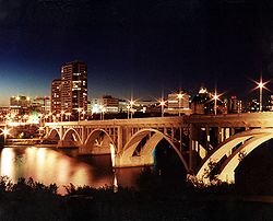
| Circle Drive Bridge Circle Drive Bridge (Saskatoon) Circle Drive Bridge spans the South Saskatchewan River in Saskatoon, Saskatchewan Canada. It is a steel girder bridge, built in 1983 as part of the Circle Drive freeway system in northeast Saskatoon. At the time of construction, it cost $11.8 million to build... |
Circle Drive Circle Drive Circle Drive is a major road constructed as a ring road in Saskatoon, Saskatchewan, Canada. The northeastern portion of the road is part of the Yellowhead Highway.-History:... |
Saskatoon | twin spans, 6 lanes | 52.153°N 106.634°W |
| CPR Bridge | Canadian Pacific Railway Canadian Pacific Railway The Canadian Pacific Railway , formerly also known as CP Rail between 1968 and 1996, is a historic Canadian Class I railway founded in 1881 and now operated by Canadian Pacific Railway Limited, which began operations as legal owner in a corporate restructuring in 2001... |
52.143°N 106.641°W | ||
| University Bridge University Bridge (Saskatoon) University Bridge spans the South Saskatchewan River between Clarence Avenue and College Drive on the east shore with 25th Street on the west in Saskatoon, Saskatchewan Canada. The bridge is also known as the 25th Street Bridge and is a major commuter route between the two halves of Saskatoon... |
25th Street to College Drive | 4 lanes | 52.153°N 106.634°W | |
| Broadway Bridge Broadway Bridge (Saskatoon) Broadway Bridge is an arch bridge that spans across the east and west banks of the South Saskatchewan River in Saskatoon, Saskatchewan, Canada.-History:... |
4th Avenue to Broadway Avenue Broadway Avenue Broadway Avenue is an arterial road in Saskatoon, Saskatchewan. It begins at the east end of the Broadway Bridge and continues south until terminating at Glasgow Street in the Avalon neighbourhood.... |
4 lanes | 52.122°N 106.660°W | |
| Traffic Bridge | 3rd Avenue to Victoria Avenue | 2 lanes closed | 52.121°N 106.663°W | |
| Senator Sid Buckwold Bridge | Idylwyld Freeway (Highway 11 Saskatchewan Highway 11 Highway 11 is a major north-south highway in Saskatchewan, Canada that connects the province's three largest cities: Regina, Saskatoon and Prince Albert. It is a structural pavement major arterial highway which is approximately long. It is also known as the Louis Riel Trail after the 19th century... , Highway 16 Saskatchewan Highway 16 Highway 16 is a provincial paved highway in the Canadian province of Saskatchewan. It is the Saskatchewan section of the Yellowhead Highway, and also the Trans-Canada Highway Yellowhead section. The main purpose of this highway is to connect Saskatchewan with Canadian cities such as Edmonton and... ) |
twin spans, 6 lanes | 52.121°N 106.669°W | |
| Circle Drive South Bridge Circle Drive South Bridge Circle Drive South Bridge spans the South Saskatchewan River in Saskatoon, Saskatchewan Canada. It is a steel girder bridge, under construction as part of the Circle Drive freeway system in southern Saskatoon. At the time of construction, it was projected to cost $272.5 million to build. It is... |
Circle Drive Circle Drive Circle Drive is a major road constructed as a ring road in Saskatoon, Saskatchewan, Canada. The northeastern portion of the road is part of the Yellowhead Highway.-History:... |
6 lanes (Under construction) | 52.098°N 106.695°W | |
| Grand Trunk Bridge Grand Trunk Bridge (Saskatoon) The Grand Trunk Bridge is a Canadian steel trestle railway bridge that spans the South Saskatchewan River in Saskatoon, Saskatchewan. It was built in 1908 as part of the Grand Trunk Pacific Railway project... |
Canadian National Railway Canadian National Railway The Canadian National Railway Company is a Canadian Class I railway headquartered in Montreal, Quebec. CN's slogan is "North America's Railroad".... |
52.097°N 106.696°W | ||
| Skytrail Skytrail The Skytrail Bridge spans the South Saskatchewan River in Outlook, Saskatchewan Canada. Originally built by the Canadian Pacific Railway, it served as a railway bridge from October 23, 1912 until March 16, 1987. In 2003 it was converted to a pedestrian bridge and is now the longest pedestrian... |
Trans Canada Trail Trans Canada Trail The Trans Canada Trail is a proposed corridor in Canada. The creation of the trail was announced as part of Canada's 125th anniversary celebrations in 1992. It is expected that when complete, it will be the longest recreational trail in the world... |
Outlook Outlook, Saskatchewan -History:Settlement of the area began in the early 1900s with farmers, immigrants moving into the area looking for farmland. Outlook officially started as a settlement on August 26, 1908 when the Canadian Pacific Railway commenced the auction of lots... |
former rail bridge | 51.490°N 107.075°W |
| Outlook Bridge Outlook Bridge The Outlook Bridge is a Canadian traffic bridge that spans the South Saskatchewan River near Outlook, Saskatchewan and caries Saskatchewan Highway 15.... |
Highway 15 Saskatchewan Highway 15 Highway 15 is a highway in the Canadian province of Saskatchewan. It runs from Highway 4, 5 km south of Rosetown, to Highway 16 near Bredenbury. Highway 15 is about 444 km long. The Outlook Bridge caries Highway 15 across the South Saskatchewan River.Major communities that Highway 15 passes near... |
51.475°N 107.080°W | ||
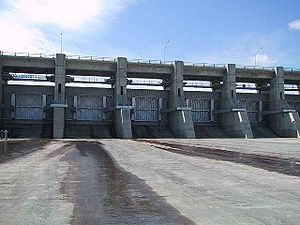
| Gardiner Dam Gardiner Dam The Gardiner Dam on the South Saskatchewan River in Saskatchewan is the largest embankment dam in Canada and one of the largest embankment dams in the world... |
Highway 44 Saskatchewan Highway 44 Highway 44 is a highway in the Canadian province of Saskatchewan. It runs from Highway 7 near Alsask to Highway 11 near Davidson. Highway 44 is about 331 km long.... |
Lake Diefenbaker Lake Diefenbaker Lake Diefenbaker is a reservoir in Southern Saskatchewan, Canada. It was formed by the construction of Gardiner Dam and the Qu'Appelle River Dam across the South Saskatchewan and Qu'Appelle Rivers respectively. Construction began in 1959 and the lake was filled in 1967. The lake is long with... |
51.259°N 106.883°W | |
| Riverhurst Ferry Riverhurst Ferry The Riverhurst Ferry is a cable ferry in the Canadian province of Saskatchewan. The ferry crosses Lake Diefenbaker, linking Riverhurst on the west bank to Lucky Lake on the east bank. The ferry is how Highway 42 crosses Lake Diefenbaker.... |
Highway 42 Saskatchewan Highway 42 Highway 42 is a highway in the Canadian province of Saskatchewan. It runs from the intersecion of Highway 2 and Highway 202 near Tuxford until Highway 15... |
15 car capacity | 50.911°N 106.930°W | |
| Saskatchewan Landing Bridge | Highway 4 Saskatchewan Highway 4 Highway 4 is a major highway in the Canadian province of Saskatchewan. It runs from U.S. Route 191 at the United States border near Monchy to Highway 224/Highway 904 at Meadow Lake Provincial Park. Highway 4 is about 653 km long.... |
50.654°N 107.968°W | ||
| Lancer Ferry Lancer Ferry The Lancer Ferry is a ferry in the Canadian province of Saskatchewan. The ferry crosses the South Saskatchewan River, linking the communities of Lancer with Eston and providing a connection between Highway 30 and Highway 32.... |
grid road | north of Lancer Lancer, Saskatchewan -External links:*********-Footnotes:... |
6 car capacity | 50.984°N 108.881°W |
| Chesterfield Bridge | Highway 21 Saskatchewan Highway 21 Highway 21 is a highway in the Canadian province of Saskatchewan. It runs from Montana Secondary Highway 233 at the United States border near Willow Creek to Highway 950/Highway 919 within the Meadow Lake Provincial Park. Highway 21 is about 722 km long.Highway 21 passes through the major... |
north of Leader Leader, Saskatchewan Leader is a town in southwestern Saskatchewan, Canada, located approximately 350 km directly east of Calgary, Alberta and is near the border between Saskatchewan and Alberta. It has a population of 881 as of 2006.-History:... |
50.971°N 109.529°W | |
| Estuary Ferry Estuary Ferry The Estuary Ferry is a ferry in the Canadian province of Saskatchewan near the ghost town of Estuary. The ferry crosses the South Saskatchewan River, providing a link between the north and south side of Range Road 635.... |
Grid road 635 Saskatchewan Highway 635 Highway 635 is a highway in the Canadian province of Saskatchewan. It runs from Highway 10 to Highway 11. Highway 635 is about 87 km long.... |
north of Estuary | 6 car capacity | 50.945°N 109.803°W |
Alberta |
||||
| Highway bridge | Highway 41 | south of Empress Empress, Alberta - See also :*List of communities in Alberta*List of villages in Alberta*Monarchy in Alberta- References :... |
50.731°N 110.069°W | |
| Maple Avenue Bridge | Altawana Drive NE to Maple Avenue | Medicine Hat Medicine Hat, Alberta Medicine Hat, known to locals as "The Hat", is a city of 61,097 people located in the southeastern part of the province of Alberta, Canada. It is enclaved within Cypress County along with the nearby Town of Redcliff, although neither is part of the county.... |
50.045°N 110.674°W | |
| Railway bridge | Canadian Pacific Railway Canadian Pacific Railway The Canadian Pacific Railway , formerly also known as CP Rail between 1968 and 1996, is a historic Canadian Class I railway founded in 1881 and now operated by Canadian Pacific Railway Limited, which began operations as legal owner in a corporate restructuring in 2001... |
50.044°N 110.676°W | ||
| Finlay Bridge | 2nd Avenue NE to 6th Avenue SE | 50.043°N 110.679°W | ||
| Highway bridge | Highway 1 | twin spans | 50.044°N 110.719°W | |
| Highway bridge | Highway 879 | northwest of Bow Island | 49.905°N 111.477°W | |
Pipeline bridge
The pipeline suspension bridge was erected in 1957 19 kilometres (11.8 mi) west of BurstallBurstall, Saskatchewan
Burstall is a small town in southwestern Saskatchewan, Canadawith a population of approximately 500. During summer the local Lions Club organizes an activity known as Summer Slam. The main economies in the area are natural gas as well as wheat and cattle farming. The area was originally settled by...
across the South Saskatchewan River.
Proposed crossings
South Circle Drive Bridge is a bridge proposed to open 2012 completing Circle DriveCircle Drive
Circle Drive is a major road constructed as a ring road in Saskatoon, Saskatchewan, Canada. The northeastern portion of the road is part of the Yellowhead Highway.-History:...
around Saskatoon
Saskatoon
Saskatoon is a city in central Saskatchewan, Canada, on the South Saskatchewan River. Residents of the city of Saskatoon are called Saskatonians. The city is surrounded by the Rural Municipality of Corman Park No. 344....
. The city of Medicine Hat
Medicine Hat, Alberta
Medicine Hat, known to locals as "The Hat", is a city of 61,097 people located in the southeastern part of the province of Alberta, Canada. It is enclaved within Cypress County along with the nearby Town of Redcliff, although neither is part of the county....
hosted a public meeting proposing a Sanitary Sewer and Water Pipeline which is intended to cross the South Saskatchewan River.