

List of airports in Burma
Encyclopedia
Airport
An airport is a location where aircraft such as fixed-wing aircraft, helicopters, and blimps take off and land. Aircraft may be stored or maintained at an airport...
s in Burma (Myanmar), grouped by type and sorted by location.
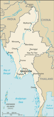
Burma, officially the Union of Myanmar, is the largest country by geographical area in Indochina
Indochina
The Indochinese peninsula, is a region in Southeast Asia. It lies roughly southwest of China, and east of India. The name has its origins in the French, Indochine, as a combination of the names of "China" and "India", and was adopted when French colonizers in Vietnam began expanding their territory...
(mainland Southeast Asia
Southeast Asia
Southeast Asia, South-East Asia, South East Asia or Southeastern Asia is a subregion of Asia, consisting of the countries that are geographically south of China, east of India, west of New Guinea and north of Australia. The region lies on the intersection of geological plates, with heavy seismic...
). The country is bordered by People's Republic of China
People's Republic of China
China , officially the People's Republic of China , is the most populous country in the world, with over 1.3 billion citizens. Located in East Asia, the country covers approximately 9.6 million square kilometres...
to the northeast, Laos
Laos
Laos Lao: ສາທາລະນະລັດ ປະຊາທິປະໄຕ ປະຊາຊົນລາວ Sathalanalat Paxathipatai Paxaxon Lao, officially the Lao People's Democratic Republic, is a landlocked country in Southeast Asia, bordered by Burma and China to the northwest, Vietnam to the east, Cambodia to the south and Thailand to the west...
to the east, Thailand
Thailand
Thailand , officially the Kingdom of Thailand , formerly known as Siam , is a country located at the centre of the Indochina peninsula and Southeast Asia. It is bordered to the north by Burma and Laos, to the east by Laos and Cambodia, to the south by the Gulf of Thailand and Malaysia, and to the...
to the southeast, Bangladesh
Bangladesh
Bangladesh , officially the People's Republic of Bangladesh is a sovereign state located in South Asia. It is bordered by India on all sides except for a small border with Burma to the far southeast and by the Bay of Bengal to the south...
to the west, India
India
India , officially the Republic of India , is a country in South Asia. It is the seventh-largest country by geographical area, the second-most populous country with over 1.2 billion people, and the most populous democracy in the world...
to the northwest, the Bay of Bengal
Bay of Bengal
The Bay of Bengal , the largest bay in the world, forms the northeastern part of the Indian Ocean. It resembles a triangle in shape, and is bordered mostly by the Eastern Coast of India, southern coast of Bangladesh and Sri Lanka to the west and Burma and the Andaman and Nicobar Islands to the...
to the southwest, and the Andaman Sea
Andaman Sea
The Andaman Sea or Burma Sea is a body of water to the southeast of the Bay of Bengal, south of Burma, west of Thailand and east of the Andaman Islands, India; it is part of the Indian Ocean....
to the south. The country is divided into 14 administrative subdivisions, which include 7 states (pyi-ne) and 7 divisions (tyne). Its capital
Capital City
Capital City was a television show produced by Euston Films which focused on the lives of investment bankers in London living and working on the corporate trading floor for the fictional international bank Shane-Longman....
is Naypyitaw (Nay Pyi Taw) and its largest city (and prior capital) is Yangon
Yangon
Yangon is a former capital of Burma and the capital of Yangon Region . Although the military government has officially relocated the capital to Naypyidaw since March 2006, Yangon, with a population of over four million, continues to be the country's largest city and the most important commercial...
.
Airports
Airport names shown in bold have scheduled passenger service on commercial airlines.| Location served | Region/State | ICAO ICAO airport code The ICAO airport code or location indicator is a four-character alphanumeric code designating each airport around the world. These codes are defined by the International Civil Aviation Organization, and published in ICAO Document 7910: Location Indicators.The ICAO codes are used by air traffic... |
IATA IATA airport code An IATA airport code, also known an IATA location identifier, IATA station code or simply a location identifier, is a three-letter code designating many airports around the world, defined by the International Air Transport Association... |
Airport name | Coordinates Geographic coordinate system A geographic coordinate system is a coordinate system that enables every location on the Earth to be specified by a set of numbers. The coordinates are often chosen such that one of the numbers represent vertical position, and two or three of the numbers represent horizontal position... |
|---|---|---|---|---|---|
| International airports | |||||
| Mandalay Mandalay Mandalay is the second-largest city and the last royal capital of Burma. Located north of Yangon on the east bank of the Irrawaddy River, the city has a population of one million, and is the capital of Mandalay Region .... / Tada-U Tada-U Tada-U is a town in central Burma about 10km from the provincial capital of Mandalay.- References :... |
Mandalay Region | VYMD | MDL | Mandalay International Airport Mandalay International Airport Mandalay International Airport , located 35 km south of Mandalay in Tada-U, is one of only two international airports in Burma. Completed in 1999, the airport is the largest and most modern airport in the country, complete with a 14,000-foot runway and capacity to handle up to 3 million passengers... |
21°42′07"N 095°58′40"E |
| Yangon Yangon Yangon is a former capital of Burma and the capital of Yangon Region . Although the military government has officially relocated the capital to Naypyidaw since March 2006, Yangon, with a population of over four million, continues to be the country's largest city and the most important commercial... (Rangoon) |
Yangon Region | VYYY | RGN | Yangon International Airport Yangon International Airport Yangon International Airport , located in Mingaladon, at north of downtown Yangon, is the primary international airport of Myanmar and the second largest airport in the country.... |
16°54′26"N 096°07′59"E |
| Domestic airports | |||||
| Anisakan | Mandalay Region | VYAS | Anisakan Airport | 21°57′19"N 096°24′21"E | |
| Ann Ann, Burma Ann is a town in the Rakhine State of western Burma. It is served by Ann Airport.-External links:*... |
Rakhine State Rakhine State Rakhine State is a Burmese state. Situated on the western coast, it is bordered by Chin State in the north, Magway Region, Bago Region and Ayeyarwady Region in the east, the Bay of Bengal to the west, and the Chittagong Division of Bangladesh to the northwest. It is located approximately between... |
VYAN | Ann Airport | 19°46′08"N 094°01′34"E | |
| Bagan Bagan Bagan , formerly Pagan, is an ancient city in the Mandalay Region of Burma. Formally titled Arimaddanapura or Arimaddana and also known as Tambadipa or Tassadessa , it was the capital of several ancient kingdoms in Burma... / Nyaung-U Nyaung-U Nyaung-U is the administrative town of Nyaung-U Township of Nyaung-U District in the Mandalay Region of central Myanmar. It lies on the eastern bank of Ayeyarwaddy River. It is just 4 kilometers away from old Bagan, a popular tourist attraction. The Shwezigon Pagoda is located there... |
Mandalay Region | VYBG | NYU | Nyaung U Airport Nyaung U Airport Nyaung U Airport is an airport located in Nyaung U , a town in the Mandalay Division of central Burma. It is the primary air gateway to the city of Bagan and surrounding areas. It also known as Nyaung Oo Airport or Bagan Nyaung Oo Airport.-Facilities:The airport resides at an elevation of above... |
21°10′43"N 094°55′48"E |
| Bhamo Bhamo Bhamo is a city of Kachin State in northernmost part of Myanmar, located 186 km south from the capital city of Myitkyina. It is on the Ayeyarwady River. It lies within 65 km of the border with Yunnan Province, China. The population consists of Chinese and Shan, with Kachin peoples in... (Banmaw) |
Kachin State Kachin State Kachin State , is the northernmost state of Burma. It is bordered by China to the north and east; Shan State to the south; and Sagaing Division and India to the west. It lies between north latitude 23° 27' and 28° 25' longitude 96° 0' and 98° 44'. The area of Kachin State is . The capital of the... |
VYBM | BMO | Bhamo Airport Bhamo Airport Bhamo Airport is an airport serving Bhamo , a city in the Kachin State in northern Burma. It is also known as Banmaw Airport.-History:... (Banmaw Airport) |
24°16′15"N 097°14′49"E |
| Bokpyin Bokpyin -External links:*[ East Satellite map at Maplandia.com]... (Bokepyin) |
Tanintharyi Region | VYBP | Bokpyin Airport | 11°16′N 098°46′E | |
| Coco Islands Coco Islands Coco Islands are a pair of strategically important islands located in the eastern Indian Ocean, politically administered by Burma under Yangon Division. They are allegedly leased to the People's Republic of China since 1994... (Great Coco Island) |
Yangon Region | VYCI | Coco Island Airport | 14°08′29"N 093°22′06"E | |
| Dawei Dawei -Transport:Only recently Dawei was connected to the rest of Myanmar by road and rail. There are plans to construct a deepwater port in Dawei. In November 2010, the Myanmar Port Authority signed a USD $8.6 billion deal with Italian-Thai Development to develop a deep sea port at Dawei... (Tavoy) |
Tanintharyi Region | VYDW | TVY | Dawei Airport Dawei Airport Dawei Airport is an airport serving Dawei , a city in the Tanintharyi Division in southeastern Burma.-Facilities:The airport resides at an elevation of above mean sea level. It has one runway designated 16/34 with a concrete surface measuring .-Airlines and destinations:... |
14°06′13"N 098°12′13"E |
| Gangaw Gangaw Gangaw is a town of Gangaw Township in Gangaw District in the Magway Division in Myanmar. Gangaw is also known as the City of Yaw, a certain region in Myanmar including Gangaw, Tilin, Saw and villages around them... |
Magway Region | VYGG | GAW | Gangaw Airport | 22°10′29"N 094°08′04"E |
| Gwa GWA GWA may stand for:* Genome-wide association study* George Walton Academy, a college preparatory school.* Georgia Writers Association* God's Wife of Amun* Google Web Accelerator, a software utility* GWA International Limited, an Australian company... |
Rakhine State Rakhine State Rakhine State is a Burmese state. Situated on the western coast, it is bordered by Chin State in the north, Magway Region, Bago Region and Ayeyarwady Region in the east, the Bay of Bengal to the west, and the Chittagong Division of Bangladesh to the northwest. It is located approximately between... |
VYGW | GWA | Gwa Airport | 17°36′N 094°35′E |
| Heho Heho Heho is a small town in Kalaw Township, Taunggyi District, Shan State of Myanmar . It is the primary air gateway to tourist areas such as Inle Lake.Heho is connected by NH4 to Sakangyi and Taunggyi, the capital of the Shan State in the east... |
Shan State Shan State Shan State is a state of Burma . Shan State borders China to the north, Laos to the east, and Thailand to the south, and five administrative divisions of Burma in the west. Largest of the 14 administrative divisions by land area, Shan State covers 155,800 km², almost a quarter of the total... |
VYHH | HEH | Heho Airport Heho Airport -History:The airport served as an airbase both for the Allies and the Japanese during World War II. The airbase was heavily bombed by the Allies. Evidence of aircraft bunker revetments and bomb craters can still be seen on the southern end of the airfield, especially noticeable from the... |
20°44′49"N 096°47′31"E |
| Homalin Homalin Homalin or Hommalinn is a small town in northwestern Burma and capital of the Homalin Township in Hkamti District of the Sagaing Division. The town lies on the Chindwin River and is served by Homalin Airport.... (Hommalin) |
Sagaing Region | VYHL | HOX | Homalin Airport (Hommalin Airport) | 24°53′58"N 094°54′50"E |
| Hpa-An Hpa-An -Education:* Computer University, Hpa-An* Hpa-An Education College* Hpa-An University* Technological University, Hpa-An* Hpa-An Nursing Training School-Religion:... (Pa-An) |
Kayin State Kayin State Kayin State is a state of Burma . The capital city is Hpa-an.-History:The region that forms today's Kayin State was part of successive Burmese kingdoms since the formation of the Pagan Empire in mid-11th century... |
VYPA | PAA | Hpa-An Airport | 16°53′37"N 097°40′28"E |
| Hpapun Hpapun Papun is a town in the Kayin State of southern Burma. It is on the east side of the Yunzalin River.-External links:*, Maplandia.com]... (Papun) |
Kayin State Kayin State Kayin State is a state of Burma . The capital city is Hpa-an.-History:The region that forms today's Kayin State was part of successive Burmese kingdoms since the formation of the Pagan Empire in mid-11th century... |
VYPP | PPU | Hpapun Airport | 18°04′N 097°27′E |
| Kalaymyo Kalaymyo Kalaymyo , also known as Karlaymyo, is a town in the Sagaing Division of Burma. It is located upstream from Mandalay and Monywa on the Myittha River, a tributary of the Chindwin River. The town is the district headquarters of the Kalay District... (Kalemyo) |
Sagaing Region | VYKL | KMV | Kalaymyo Airport Kalaymyo Airport Kalaymyo Airport is an airport serving Kalaymyo , a town in the Sagaing Division of Burma.-Airlines and destinations:... |
23°11′19"N 094°03′03"E |
| Kawthaung Kawthaung Kawthaung is in the southernmost part of Myanmar, located in Tanintharyi Region. During British rule in Burma between 1824 and 1948, it was known as Victoria Point.- History :... (Kawthoung) |
Tanintharyi Region | VYKT | KAW | Kawthaung Airport Kawthaung Airport Kawthaung Airport is an airport in Kawthaung, Burma. The airport has a very small terminal with no gates. The airport has a 1800 x 50 meter runway.-Airlines and destinations:... |
10°02′57"N 098°32′16"E |
| Kengtung (Kengtong, Kyaingtong) | Shan State Shan State Shan State is a state of Burma . Shan State borders China to the north, Laos to the east, and Thailand to the south, and five administrative divisions of Burma in the west. Largest of the 14 administrative divisions by land area, Shan State covers 155,800 km², almost a quarter of the total... |
VYKG | KET | Kengtung Airport Kengtung Airport -Airlines and destinations:... |
21°18′05"N 099°38′09"E |
| Khamti Singkaling Hkamti Khamti, Hkamti, Singkaling Hkamti, Singkawng, Kanti or Kantee is a town in Hkamti District, Sagaing Division, in northwestern Burma... |
Sagaing Region | VYKI | KHM | Khamti Airport Khamti Airport Khamti Airport , also known as Hkamti Airport, is an airport serving Khamti , a town in the Khamti District of the Sagaing Division in northwestern Burma.-Facilities:... |
25°59′18"N 095°40′28"E |
| Kyaukpyu Kyaukpyu Kyaukpyu is a major town in Rakhine State, in western Myanmar. It is located on the north western corner of Yanbye Island on Combermere Bay, and is 250 miles northwest of Yangon. The town is situated on a superb natural harbor which connects the rice trade between Calcutta and Yangon... (Kyauk Pyu) |
Rakhine State Rakhine State Rakhine State is a Burmese state. Situated on the western coast, it is bordered by Chin State in the north, Magway Region, Bago Region and Ayeyarwady Region in the east, the Bay of Bengal to the west, and the Chittagong Division of Bangladesh to the northwest. It is located approximately between... |
VYKP | KYP | Kyaukpyu Airport Kyaukpyu Airport Kyaukpyu Airport is an airport in Kyaukpyu, Burma .The runway of Kyaukpyu Airport was 4,620 feet long and 100 feet wide. It is able to handle F-28 jets, aircrafts of bigger category used by Myanma Airways. The airfield is planned to extend 1000 feet in 2011 and 1400 feet in next two years. After... |
19°25′35"N 093°32′05"E |
| Kyauktu (Kyaukhtu) | Magway Region | VYKU | KYT | Kyauktu Airport | 21°24′45"N 094°08′31"E |
| Kyauktu (Kyaukhtu) | Magway Region | VYXG | Kyauktu South Airport | 21°24′26"N 094°07′31"E | |
| Lanywa Lanywa Lanywa or Lan is a town in the Magway Division in Burma on the right bank of the Irrawaddy, just above Seikphyu and Chauk. The town hosts a commercial airport, southeast of town.-External links:* Maplandia World Gazetteer... |
Magway Region | VYLY | Lanywa Airport | 20°56′25"N 094°49′21"E | |
| Lashio Lashio Lashio is the largest town in northern Shan State, Myanmar, about northeast of Mandalay. It is situated on a low mountain spur overlooking the valley of the Nam Yao river. The population grew from around 5000 in 1960 to 88,590 in 1983. It is currently estimated at around 130,000.Lashio is the... |
Shan State Shan State Shan State is a state of Burma . Shan State borders China to the north, Laos to the east, and Thailand to the south, and five administrative divisions of Burma in the west. Largest of the 14 administrative divisions by land area, Shan State covers 155,800 km², almost a quarter of the total... |
VYLS | LSH | Lashio Airport Lashio Airport Lashio Airport is an airport in Lashio, Burma. it is near the Head Quarter of Northeast Military Command. Passengers have to walk from airport building to entrance of airport compound. There is no X ray equipment.-Accidents and incident:... |
22°58′40"N 097°45′07"E |
| Loikaw Loikaw Loikaw is the capital of Kayah State in Burma . It is located near the State's northern tip, just above an embayment on the Pilu River. The inhabitants are mostly Kayah... |
Kayah State Kayah State Kayah State is a state of Myanmar. Situated in eastern Myanmar, it is bounded on the north by Shan State, on the east by Thailand's Mae Hong Son Province, and on the south and west by Kayin State. It lies approximately between 18° 30' and 19° 55' north latitude and between 94°40' and 97° 93' east... |
VYLK | LIW | Loikaw Airport | 19°41′29"N 097°12′53"E |
| Magwe Magwe, Burma Magwe is the capital city of Magway Region of Burma , and home to Magway Airport.Magway is situated on the bank of AyeYarWaddy River... |
Magway Region | VYMW | MWQ | Magwe Airport | 20°09′56"N 094°56′28"E |
| Manaung Manaung Manaung is a town and district in Manaung Township in Kyaukpyu Districtin the Rakhine State of westernmost part of Myanmar.Manaung town is situated on Manaung Island.-External links:*... |
Rakhine State Rakhine State Rakhine State is a Burmese state. Situated on the western coast, it is bordered by Chin State in the north, Magway Region, Bago Region and Ayeyarwady Region in the east, the Bay of Bengal to the west, and the Chittagong Division of Bangladesh to the northwest. It is located approximately between... |
VYMN | MGU | Manaung Airport | 18°50′45"N 093°41′20"E |
| Mandalay Mandalay Mandalay is the second-largest city and the last royal capital of Burma. Located north of Yangon on the east bank of the Irrawaddy River, the city has a population of one million, and is the capital of Mandalay Region .... |
Mandalay Region | VYCZ | Mandalay Chanmyathazi Airport Mandalay Chanmyathazi Airport Mandalay Chanmyathazi Airport is a domestic airport in Burma that served Mandalay and surrounding areas. It has largely been replaced by Mandalay International Airport.... |
21°56′25"N 096°05′22"E | |
| Mawlamyine Mawlamyine Mawlamyine is the fourth largest city of Burma , situated 300 km south east of Yangon and 70 km south of Thaton, at the mouth of Thanlwin river... (Mawlamyaing) |
Mon State Mon State Mon State is an administrative division of Myanmar. It is sandwiched between Kayin State on the east, the Andaman Sea on the west, Bago Region on the north and Tanintharyi Region on the south, and has a short border with Thailand's Kanchanaburi Province at its south-eastern tip. The land area is... |
VYMM | MNU | Mawlamyaing Airport Mawlamyaing Airport Mawlamyaing Airport is an airport in Mawlamyaing, Burma .... (Mawlamyine Airport) |
16°26′41"N 097°39′38"E |
| Momeik Momeik Momeik, known as Know as Mong Mit in Shan, is a town situated on the Shweli River in northern Shan State of Myanmar .-Transport:... |
Shan State Shan State Shan State is a state of Burma . Shan State borders China to the north, Laos to the east, and Thailand to the south, and five administrative divisions of Burma in the west. Largest of the 14 administrative divisions by land area, Shan State covers 155,800 km², almost a quarter of the total... |
VYMO | MOE | Momeik Airport | 23°05′33"N 096°38′42"E |
| Mong Ton Mong Ton Mong Ton is a town and seat of Mong Tong Township in Mong Hsat District, Shan State in eastern Myanmar near the border with Thailand. It is served by Mong Ton Airport... (Mong-Tong) |
Shan State Shan State Shan State is a state of Burma . Shan State borders China to the north, Laos to the east, and Thailand to the south, and five administrative divisions of Burma in the west. Largest of the 14 administrative divisions by land area, Shan State covers 155,800 km², almost a quarter of the total... |
VYMT | MGK | Mong Ton Airport | 20°17′48"N 098°53′56"E |
| Mong Hsat (Monghsat) | Shan State Shan State Shan State is a state of Burma . Shan State borders China to the north, Laos to the east, and Thailand to the south, and five administrative divisions of Burma in the west. Largest of the 14 administrative divisions by land area, Shan State covers 155,800 km², almost a quarter of the total... |
VYMS | MOG | Monghsat Airport (Mong Hsat Airport) | 20°31′00"N 099°15′24"E |
| Monywa Monywa Monywa is a city in Sagaing Division, Myanmar, located 136 km northwest of Mandalay on the eastern bank of the River Chindwin.-Transport:... (Monywar) |
Sagaing Region | VYMY | Monywa Airport (Monywar Airport) | 22°14′N 095°07′E | |
| Myeik (Mergui) | Tanintharyi Region | VYME | MGZ | Myeik Airport Myeik Airport -Airlines and destinations:... |
12°26′23"N 098°37′17"E |
| Myitkyina Myitkyina Myitkyina is the capital city of Kachin State in Myanmar , located from Yangon, and from Mandalay. In Burmese it means "near the big river", and in fact "Myitkyina" lies on the west bank of the Ayeyarwady River, just below from Myit-son of its two headstreams... |
Kachin State Kachin State Kachin State , is the northernmost state of Burma. It is bordered by China to the north and east; Shan State to the south; and Sagaing Division and India to the west. It lies between north latitude 23° 27' and 28° 25' longitude 96° 0' and 98° 44'. The area of Kachin State is . The capital of the... |
VYMK | MYT | Myitkyina Airport Myitkyina Airport -Airlines and destinations:-History:Built before World War II as Myitkyina Airfield, the airfield was captured by the Imperial Japanese Army on 8 May 1942 during the Japanese conquest of Burma... |
25°23′01"N 097°21′06"E |
| Namsang Namsang Nansang or Namsang is a town in Loilen District of Shan State in eastern Burma. It is the seat of Nansang Township. A pagoda lies in the southern part of the town.- Transport :... |
Shan State Shan State Shan State is a state of Burma . Shan State borders China to the north, Laos to the east, and Thailand to the south, and five administrative divisions of Burma in the west. Largest of the 14 administrative divisions by land area, Shan State covers 155,800 km², almost a quarter of the total... |
VYNS | NMS | Namsang Airport | 20°53′25"N 097°44′09"E |
| Namtu Namtu Namtu is a town in northern Shan State, Burma. Famous for its Bawdwin and Namtu silver mines, it is situated on the Nam Tu River, and is connected to Lashio by rail.-History:... |
Shan State Shan State Shan State is a state of Burma . Shan State borders China to the north, Laos to the east, and Thailand to the south, and five administrative divisions of Burma in the west. Largest of the 14 administrative divisions by land area, Shan State covers 155,800 km², almost a quarter of the total... |
VYNT | NMT | Namtu Airport | 23°05′N 097°23′E |
| Naypyidaw Naypyidaw Naypyidaw is the capital city of Burma, also known as Myanmar. It is administered as the Naypyidaw Union Territory, as per the 2008 Constitution. On 6 November 2005, the administrative capital of Myanmar was officially moved to a greenfield 3.2 km west of Pyinmana, and approximately... (Naypyitaw) |
Mandalay Region | VYEL | Naypyidaw Airport (Ela Airport) | 19°37′24"N 096°12′03"E | |
| Pakokku Pakokku Pakokku or Pa Kok Ku is a town in the Magway Division in Myanmar. It is situated about 30 km northwest of Bagan on the Ayeyarwady River. It is the second most important education center for Sangha after Mandalay. It is the administration seat of Pakokku Township and Pakokku District.The town... |
Magway Region | VYPU | PKK | Pakokku Airport Pakokku Airport Pakokku Airport is an airport in Pakokku, Burma .-Airlines and destinations:... |
21°20′N 095°06′E |
| Pathein Pathein Pathein , also called Bassein, is a port city with a 2004 population estimated at 215,600, and the capital of the Ayeyarwady Region, Burma. It lies on the Pathein River , which is a western branch of the Irrawaddy River.... (Bassein) |
Ayeyarwady Region | VYPN | BSX | Pathein Airport | 16°48′54"N 094°46′47"E |
| Pauk Pauk Pauk is a town in Pauk Township, Pakokku District, Magway Division, in northwest Burma . It is the administrative center for Pauk Township. Pauk is located on the western bank of the Kyaw River just above its intersection with the Yaw River.... |
Magway Region | VYPK | PAU | Pauk Airport Pauk Airport Pauk Airport is an airport located in Burma near Pauk.... |
21°26′57"N 094°29′13"E |
| Putao Putao Putao is the northernmost town of Kachin State, Myanmar and is the site of the World War II British Fort Hertz. It is the principal town in Putao Township. It can only be reached by road during summer but is accessible year round by air if there are sufficient tourist groups to justify a plane... |
Kachin State Kachin State Kachin State , is the northernmost state of Burma. It is bordered by China to the north and east; Shan State to the south; and Sagaing Division and India to the west. It lies between north latitude 23° 27' and 28° 25' longitude 96° 0' and 98° 44'. The area of Kachin State is . The capital of the... |
VYPT | PBU | Putao Airport | 27°19′47"N 097°25′34"E |
| Pyay Pyay Pyay is a town in the Bago Division in Burma. It has an estimated population of 123,800 . Pyay is positioned on the Ayeyarwady River and is northwest of Yangon.... (Prome) |
Bago Region | VYPY | PRU | Pyay Airport | 18°49′28"N 095°15′57"E |
| Paletwa Paletwa Paletwa is one of the westernmost towns of Burma , in Chin State 18 kilometres from the border with Bangladesh. It is the administrative seat for Paletwa Township.-External links:*... (Paletwa) |
Chin State Chin State Chin State is a state located in western Burma . The Chin State is bordered by Rakhine State in the south, Bangladesh in south-west, Sagaing Division and Magway Division in the east, Indian state of Manipur in the north and Indian state of Mizoram in the west. The Chin ethnic group make up the... |
VYPE | Paletwa Airport | 21°18′0"N 092°55′1"E | |
| Sittwe Sittwe -Economy:In February 2007, India announced a plan to develop the port, which would enable ocean access from Indian Northeastern states, so called "Seven sisters", like Mizoram, via the Kaladan River.... (Akyab) |
Rakhine State Rakhine State Rakhine State is a Burmese state. Situated on the western coast, it is bordered by Chin State in the north, Magway Region, Bago Region and Ayeyarwady Region in the east, the Bay of Bengal to the west, and the Chittagong Division of Bangladesh to the northwest. It is located approximately between... |
VYSW | AKY | Sittwe Airport Sittwe Airport Sittwe Airport is an airport in Sittwe, Rakhine State, Burma.It started as a military used arifield in World War II. It was handed over to Department of Civil Aviation by International Aero Limited Company on 24 July 1947. It was upgraded to 6,000 feet long and 140 feet wide gravel mixed asphalt... |
20°07′57"N 092°52′21"E |
| Tachileik Tachileik Tachileik , is a border town in the Shan State of eastern Burma . It is the administrative seat of Tachileik Township and Tachileik District.-History:... (Tachilek) |
Shan State Shan State Shan State is a state of Burma . Shan State borders China to the north, Laos to the east, and Thailand to the south, and five administrative divisions of Burma in the west. Largest of the 14 administrative divisions by land area, Shan State covers 155,800 km², almost a quarter of the total... |
VYTL | THL | Tachilek Airport Tachilek Airport Tachilek Airport or Tachileik Airport is an airport serving Tachilek , a town in the Shan State of eastern Burma.-Airlines and destinations:... |
20°29′01"N 099°56′07"E |
| Thandwe Thandwe -Ngapali Beach:Ngapali Beach is a beach located 7 kilometres from the town of Thandwe , in Rakhine State, Myanmar. It is the most famous beach in Myanmar and is a popular tourist destination... (Sandoway) |
Rakhine State Rakhine State Rakhine State is a Burmese state. Situated on the western coast, it is bordered by Chin State in the north, Magway Region, Bago Region and Ayeyarwady Region in the east, the Bay of Bengal to the west, and the Chittagong Division of Bangladesh to the northwest. It is located approximately between... |
VYTD | SNW | Thandwe Airport Thandwe Airport Thandwe Airport is an airport serving Thandwe, a town in the Rakhine State of Burma.- Airlines and destinations :-Accidents and incidents:... |
18°27′38"N 094°18′00"E |
| Tilin Tilin Tilin, Tilim or Htilin is a town in Gangaw District in the Magway Region of Burma . It is the administrative seat for Tilin Township.-External links:* Maplandia... |
Magway Region | VYHN | TIO | Tilin Airport | 21°42′N 094°06′E |
| Ye Ye, Mon State Ye is a town in the southern end of Mon State, Myanmar . It is the principal town of Ye Township of Mawlamyine District. The town is located by the Ye river as it drains into the Gulf of Martaban, and is surrounded by Tenasserim Hills in the east. It has a warm, moderate weather. The town's... |
Mon State Mon State Mon State is an administrative division of Myanmar. It is sandwiched between Kayin State on the east, the Andaman Sea on the west, Bago Region on the north and Tanintharyi Region on the south, and has a short border with Thailand's Kanchanaburi Province at its south-eastern tip. The land area is... |
VYYE | XYE | Ye Airport | 15°18′N 097°52′E |
| Military airports | |||||
| Hmawbi (Hmawby) | Yangon Region | VYHB | Hmawbi Air Base | 17°07′N 96°04′E | |
| Meiktila Meiktila Meiktila is a city in central Myanmar, located on the banks of Lake Meiktila in Mandalay Division, at the junctions of the Bagan-Taunggyi, Yangon-Mandalay and Meiktila-Myingyan highways. Because of its strategic position, Meiktila is home to Myanmar Air Force's central command and Meiktila Air... |
Mandalay Region | VYML | Meiktila Air Base | 20°53′N 095°53′E | |
| Meiktila Meiktila Meiktila is a city in central Myanmar, located on the banks of Lake Meiktila in Mandalay Division, at the junctions of the Bagan-Taunggyi, Yangon-Mandalay and Meiktila-Myingyan highways. Because of its strategic position, Meiktila is home to Myanmar Air Force's central command and Meiktila Air... |
Mandalay Region | VYST | Shante Air Base | 20°56′30"N 095°54′52"E | |
| Myitkyina Myitkyina Myitkyina is the capital city of Kachin State in Myanmar , located from Yangon, and from Mandalay. In Burmese it means "near the big river", and in fact "Myitkyina" lies on the west bank of the Ayeyarwady River, just below from Myit-son of its two headstreams... |
Kachin State Kachin State Kachin State , is the northernmost state of Burma. It is bordered by China to the north and east; Shan State to the south; and Sagaing Division and India to the west. It lies between north latitude 23° 27' and 28° 25' longitude 96° 0' and 98° 44'. The area of Kachin State is . The capital of the... |
VYNP | Nampong Air Base | 25°21′15"N 097°17′42"E | |
See also
- Myanmar Air Force
- Transport in Burma
- List of airports by ICAO code: V#VY - Myanmar (Burma)
- Wikipedia:WikiProject Aviation/Airline destination lists: Asia#Myanmar (Burma)